
THE CARDINAL POINTS OF THE COMPASS of North America include the EAST COAST-CHESAPEAKE BAY. This promontory has experienced a GRAVITATIONAL DISRUPTION at the 8 m.y. AGE, which displays an ANALEMMA and enclosed ARCS, YIELDING the AGE. This fits the BINARY THEOREM, DEVELOPED from shearing experienced NEAR VANCOUVER ISLAND, CANADA. This was PRE-ICE AGE, and illustrates the unity of CRUSTAL REACTIONS to GRAVITATIONAL PERTURBATIONS. PUGET SOUND FOLLOWS, with FRAGMENTATION OCCURRING AFTER 2 M.Y. (including my home base of Whidbey Island).


 There have been extinctions, disruptions, and fragmentation of islands at the cardinal compass points- exhibited by GRAVITATIONAL ADJUSTMENTS at TIMES in million years: 256, (East Indies) 64 (West Indies), 16 (Columbia flood basalts), 4 (NW Passage), and 1 m.y. (equating TIME and SPACE). Now we find that this has continued at: 250k.y, 62.5k.y, 15,625 years at Penn cove- at the last right angle turn (to the west) of the ice, from its normal southward path through WA state (Penn Cove waterway is shown above, along with a major ANOMALY 100 meters west of the city dock- note the abnormal spacing of N-S and E-W GRIDLINES AT THE BOTTOM OF THE COVE: 1km and 1.63km, the ratio of diameters in an ANALEMMA). This has confirmed that the CW rotation of the disruptions, starting at the 256 m.y. extinction inflicted on the eastern-most part of the American EAST COAST, has continued through Yucatan, to Mendocino and Olympic Peninsula, to the Hudson Bay-NW passage, AND NOW AT THE CONTINUATION OF THE SERIES, at end of PLEISTOCENE TIME.
I hesitated to scribe that the circular relation of time and space continues, but the PENN COVE anomaly has hinted that this GRAVITATIONAL ADJUSTMENT is still in effect. This infers that we must consider that the process continues, indicating that the time intervals of 3906.25 (1894 BC- Egyptian disruption), 976.56, 244.14, 61.04 (1950 Korean War), 15.26, 3.815 (2008 AD), and .954 years (NOW) are important for the affairs of MAN!
Were the MAYANS correct in finding that the end of 2012 AD, would be the end of a great cycle? It appears that the predicted “FLIP” of the magnetic poles, the inflection in a 23.5 k.y. MILANKOVITCH CYCLE, and the conjunction of the FULL MOON, Jupiter, and Venus are imminent, causing a major disruption at the end of 2012. This is in effect NOW (with Venus and Jupiter adjusting the gravitational attraction), to create extra influence of the LUNAR-SOLAR offset at the conflict at the SE USA. This conflict or offset creates a LINEAR, along which there was a line of tornadoes this last month. Now the gravitational adjustment continues, and we have had our WARNING with the Clintonville, WI BANGS- which align N-S, with the CHICXULUB 64 M.Y. site, New Madrid 1812 major quake ANALEMMA, and the Hudson Bay CENTER to later NW Passage-Byam Martin Island of 4 m.y. AGE.

THE CARDINAL POINTS OF THE COMPASS of North America include the EAST COAST-CHESAPEAKE BAY. This promontory has experienced a GRAVITATIONAL DISRUPTION at the 8 m.y. AGE, which displays an ANALEMMA and enclosed ARCS, YIELDING the AGE. This fits the BINARY THEOREM, DEVELOPED from shearing experienced NEAR VANCOUVER ISLAND, CANADA. This was PRE-ICE AGE, and illustrates the unity of CRUSTAL REACTIONS to GRAVITATIONAL PERTURBATIONS. PUGET SOUND FOLLOWS, with FRAGMENTATION OCCURRING AFTER 2 M.Y. (including my home base of Whidbey Island).
 TUNGUSKA, SIBERIA has been widely accepted by GEOLOGISTS as a site of an ASTEROID STRIKE (A DRASTIC BLOW-DOWN of TREES- not investigated until following years, since this is in MUSKEG, and no one lived there to witness). As usual, this is INCORRECT, WITH ANALYSIS which shows that the EVENT OCCURRED INSIDE CONCENTRIC ELLIPSES-SOME AS OLD AS 80 M.Y. AGE. THIS is ANOTHER CASE OF GRAVITATIONAL DISRUPTION (AN INSTABILITY, INSIDE THE FORBIDDEN ZONE OF FRAGMENTATION- SUCH AS OCCURS IN SPACE, IN THE ASTEROID, KUIPER, AND OORT BELTS, WHICH FRAGMENTS ANY PLANET OCCURRENCE). WE WILL HAVE TO RE-OPEN ALL CASES OF SO-CALLED ASTEROID CRATERS, SINCE THE ONES I HAVE ANALYZED ARE SINKS- THE INVERSE of MOUNDS (VERTICAL ROUND HOLES IN THE CRUST, DUE TO BLOWOUTS OF GAS OR SHEAR OF FEATURES, SUCH AS SHEAR AT THE MOGOLLON RIM).
EVENT AGE POSITION LOCATION FULCRUM BEYOND PTr 256 m.y. SW coast, Australia Spratly I. 5000km/N (2x KT)
KT 64 M.Y. Yucatan Mexico Cayman SE900km, Curacao 2600km
Flood basalt 16 OR WA USA Olympic R.-Siskiyou 590km/60 (1/4)
Hudson Byam 4 Canada NW passage 1856km/347, NNW (1/1.4)
Chesapeake 8 USA Cape Hatteras 362 km/N (1/8th)
Puget Sound 15,625 USA Olympic Mt. 98km/E E. side of SOUND
RATIOS of FRAGMENTATION separation are in the 2x ORDER, except for NW passage, and 1/26.5 (near 1/24th) for Puget sound, or the ELLIPSE formed at Byam Martin Island. This requires an investigation into the excessive elliptical extension to the north. This is the method FROM gravitational perturbances, which form an ELLIPSE ENCLOSING an ANALEMMA. THIS EXPLAINS THE SHAPE, but NOT the FRAGMENTATION! It appears that WAVES have destructive power, in both SPACE and at ORTHOGONAL (CARDINAL POINTS of the COMPASS) extremities on continents. Notice that the FRAGMENTATION OCCURS at borders of land mass (coastlines), and that the SEPARATION DECREASES with time- since the AGE of the EVENTS. The important question to ask: “1. Why does the severity decrease with time, and 2. why does it occur at extremities?”
The answer to 1. the edge-of-continent query, should be: GRAVITY WAVES fashion most obviously at the contrast of LOW DENSITY SEAWATER and HIGH DENSITY ROCK (note that basalt contrasts more than continental crust, with water, and that OCEANIC VOLCANOES fragment more rapidly than near-coastal volcanoes: witness MAUI, of 2 m.y- compared to SAN FRANCISCO PEAKS, AZ, which are just beginning to fragment.
2. The distance of EARTH from SUN increases with TIME (EARTH ORBIT SLOWS, and the earth;s ORBITAL ellipse ELONGATES). It has been reported that the 100 k.y. MILANKOVITCH CYCLE has become noticeable in ICE AGE CORING, (less than 2 m.y.) and there occur million year and 2 m.y. ellipses in rock outcrops. There may be Critical DISTANCES, above which gravitational destruction becomes of lesser importance!
A case FOR COMPARISION *, for viewing COMMONALITIES OF MOON'S INFLUENCE in DETERMINING ANALEMMAS and LINEAR WASATCH LINE SEPARATION of AXIAL-PRECESSIONAL CELLS (with 1.6 RATIO of DIAMETERS and TILTED BASIN & RANGE ARCUATE FEATURES, is that of AUSTRALIA. THIS CASE is in the southern hemisphere, has 30.72 mm/year TIDAL MOVEMENTS (ADDITIVE TIDES, COMPARED to Northern hemisphere and 20.48 westward-moving TIDES being OFFSET by SOLAR TIDES-EASTWARD MOVING), and is generally moving NORTHWARD

*NOTE: The GRAVITATIONAL FRAGMENTATION SCENARIO requires that we find a FLAT-and-LEVEL ROCK FORMATION, which has survived the 1024 billion year destruction, in order to disprove the episode. It is not enough to find an outcrop which has been “saved” in a graben or other protected environment. The grand canyon 1.1 b.y. deposit is in a tilted position, and appears to remain because it has apparently dropped into the crevasse while the several m.y. episodes occurred. I have found that these fragmentations occur over several million years, as seen in the transition of type of sedimentary deposits found from PTr to the Triassic Chinle petrified wood much higher in the stratigraphic column (3-5 m.y. later). I have found that there are many outcrops of 1.7 b.y. metasediments remaining in AZ and NM, and I had a ranch which exhibited these vertically-oriented rocks. The grain of the rocks was generally upward, and this is not necessarily the same as the original bedding planes. It merely indicates that the compression was lateral- where the grain is perpendicular to the direction of shove. How is it that some older rock was not “scalped” during the destruction? The fact of their appearance at the surface tells us that there has been NO deposition., and that likely they were partially planed by the destruction- leaving the part that was not “shaved”. These metasediments occur in a belt from Minnesota to Mexico, as shown in a plan view below. Notice that the trend is arcuate, indicating that the influence of GRAVITATION was similar to now. We cannot tell if the orientation occurred contemporaneously with their uplift, and it might have been imposed on the chain later (a moving feature describes the time interval of the arc, and the AGE of the event may be calculated by: diameter, km/10.24 km/m.y. for arcs convex to the east. Oppositely-oriented arcs have 20 km/m.y. TIDAL MOVEMENTS to the west). An EVENT which might be helpful is the occurrence of an uplift or intrusion- such as the Dewey Batholith- which rose after the 1.024 b.y. EVENT. THIS CASE occurs as a result of the ISOSTASY transpiring after the opening in the crust (and removal of overburden) has occurred. This will be an indicator of the longevity of the EVENT- CREATING UPLIFTS long after the original GRAVITATIONAL FRAGMENTATION.
Notice that the trend is convex to the east for the cross-continent outcrops, and the AGE is greater than 10,000km/10 km/m.y. or > 1 b.y:

AZ Texas GULCH:
THE CALCULATIONS ABOUT THE LINEAR FAULT INDICATE THAT THE OLDER ARC HAS AN AGE OF 578 m.y. THIS IS NOT CORRECT, AND RELATES AGAIN, THAT AGE MUST NOT BE CALCULATED AT OR NEAR A SOLAR VS. LUNAR LINEAR; THE FEATURE CHANGES SO RAPIDLY ON GOOGLE EARTH- from left to right- THAT THERE IS GREAT PERSONAL ERROR IN MEASURING AND CALCULATING THE AGE (BECAUSE OF THE GREAT CHANGES FOR SMALL SEPARATIONS OF ARCS). HOWEVER, THE ARC TO THE WEST YIELDS AN AGE OF KT- THE CRETACEOUS-TERTIARY BOUNDARY. GEOLOGISTS RELATE THAT THE AGE OF THE DEWEY BATHOLITH IS CRETACEOUS IN AGE, AND THIS FARTHER-FROM-THE-LINEAR ARC POSSIBLY IS CORRECT. I USED THE AVERAGE OF ALL MY FINDINGS- for CONVEX to the EAST FEATURES- TO USE THE DIVISOR OF 10.24KM/M.Y., AND ONE COULD USE THE SMALLEST MEASUREMENT OF 3.072KM/M.Y. TO CALCULATE AN ADJUSTED AGE OF 10.24/3.072 X 578m.y.= 1.926 m.y. (13% error), but STATISTICALLY, I cannot justify it.
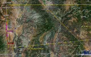
AZ PC MOUNTAINS:
TAKING ANOTHER PART OF THE AZ PC, ALONG 1-17 and Cordes Lakes, we see that the LATERAL FAULTS CALCULATE LESS THAN 1 m.y.; I HAVE WORKED THIS AREA CONSIDERABLY, and know that the rocks are of 1.7 m.y. AGE. WE HAVE TO CONCLUDE THT THIS TECHNIQUE IS NOT SENSITIVE ENOUGH FOR THESE LARGE DIAMETER ARCS TO BE USED FOR AGE CALCULALTIONS.
THE ICE AGE IS RELATED TO THE TIME INTERVAL SHOWN IN THE PHOTO BELOW. THIS FEATURE WAS INITIATED AT THE TIME OF THE "SUPPOSED" ELTANIN EVENT. THIS HAS BEEN INVESTIGATED BY GEOLOGISTS AS A METEOR STRIKE IN THE SOUTHERN OCEAN. I HAVE FOUND THAT ELTANIN OCCURRED IN RESPONSE TO THE INTERIM BETWEEN THE 4 AND 1 M.Y. GRAVITATIONAL FRAGMENTATIONS, AND CREATED COOLING (ICE) VIA EXTENSION OF THE ELLIPTICAL PATH OF THE EARTH. IT TERMINATED AT PENN COVE, WHIDBEY ISLAND, WA AT 15,625 YEARS AGO-MAKING A TURN OF THE LAST ICE LOBE TOWARDS THE WEST. IN RESPONSE, THERE OCCURRED MIMA MOUNDS NEAR MY SUMMER HOME, ONLAND, AND IN THE SARATOGA PASSAGE- AS SIMILAR-SIZED DIFFRACTION PATTERNS OF SUB-SEA MOUNDS. NOW WE SEE THAT IT "SQUEEZED" MINGUS AND WOODCHUTE MOUNTAINS (VOLCANOES) UPWARD VIA OPPOSING LINAR AND SOLAR TIDES. I NOW BELIEVE THE SQUEEZING PRODUCED THE MOUNDS AND DIFFRACTION PATTERNS:
A CLUE TO CONFLICT IN LUNAR AND SOLAR TIDES (CAUSING SQUEEZING, OR OPPOSITELY, CANYON OPENING) IS THE TRAPEZOIDAL ARRANGEMENT OF MILANKOVITCH AXIAL AND ELLIPTICAL DISPLAYS OF ROCK OUTCROPS. ABOVE (CLICK TO ENLARGE) IS SHOWN HOW THE VERDE RIVER- IN PLIOCENE VERDE FORMATION- FORMS LINEARS. THESE FORM WHENEVER THERE IS SHEAR STRESS, LATER REVERSING OVER ADJACENT LINEAR PATHS. I LIVED IN THE COTTONWOOD, AZ AREA 18 YEARS, AND ALWAYS WONDERED HOW VOLCANOS FORMED ON TOP OF A NARROW RIDGE (YOU COULD SEE BOTH PRESCOTT AND VERDE VALLEYS AT THE TOP OF THE RIDGE). THE SCARP WAS SO STEEP THAT LOGGERS COULD CUT PONDEROSA PINES AND SLIDE THEM DOWN THE SCARP INTO THE MINING TOWN OF JEROME (hence the name Woodchute):
ABOVE IS AN ATMOSPHERIC ANALEMMA (LARGE AXIAL AND SMALLER CW PRECESSIONAL CELLS), WHICH DEMONSTRATES THAT THE SAME MILANKOVITCH CYCLES OCCUR IN CLOUDS AS IN THE CRUST OF THE EARTH.

EQUINOX SHIFT of 3 degrees (21.5 to 24.5?) is measured between the GAKKEL and LOMOMOTOV RIDGES for the TIME INTERVAL of 41 m.y.; SINCE GAKKEL SPREADING RIDGE has HEAT EMISSIONS, this is PROBABLY the AGE also. I have found this TIME INTERVAL in many locations: the ALEUTIANS, CENTRAL AMERICA, OLYMPIC MTS, WA, and now at the CRITICAL LOCATION- the NORTH POLE!
NOTE: Although the measured difference in elevation between POLAR and EQUATORIAL DIAMETERS is about 30 km (3/10th %), the BINARY THEOREM predicts that the PEAR-SHAPED BULGE has a 40,960 km circumference compared to 40,000 km (2.4% difference).
This can be measured or calculated via the separation of major transforms, where there is 7.2 degrees (1/50th of 360 degrees) in the Northern PACIFIC Ocean. This is equivalent to 432 nautical miles, or 800 km, (x 1.85185, and 50 x 800= 40K) and is the first clue that the Earth resonates at critical portions of the circumference. However, if the BT is correct, the separation in the South PACIFIC will be 7.3 degrees or larger (2.7%). The events shown in my analyses occurred at 40 and 40.96 m.y.- a difference of 2.4%. The Mendocino TRANSFORM leads to the 40-41 m.y. Kimmei seamount at the major inflection in the North PACIFIC; other indications occur at the ALEUTIAN SPIRAL, the Olympic Mts. slide over the WA Puget Sound area, and the Central American curlicue. This larger TIME yields a larger bulge circumference of 40,960 km, and the imprecise separation of S. PACIFIC transforms is about 7.4 degrees (2.78% difference). The imprecision occurs with the lack of location of the bulge. There is quite a variation of transform separation, and this is due to the unknown center of BULGE location. The Atlantic Ocean gives NO hint of a bulge there, and most TRANSFORMS are more narrowly separated.
As to the measurement of the degrees of separation of the Gakkel and Lomonotov Ridges, where POLAR PRECESSIONAL SHIFT is indicated, there is significant variation for the Separation of the two ridges. I believe that these may be used as a RECORD of precessional shift through time. A graph could be made of the distance or degrees separation between the two ridges, provided one starts at the south and proceeds to the north for 12-13 incidents. This would be equivalent to the annul cycle of full moons- where there occur 12 in most years, with 1/4th having 13 full moons. There is an expected error of 1/12 for this method, since the procedure occurs for the average of FULL MOONS/YEAR. On the accompanying Google earth photo, there are shown 3 with 3 degrees and 1 with 4 degrees. This emphasizes the inaccuracy of the method. This entire analysis depends upon the relation of the RATIO of 41 m.y. precessional/2 m.y. elliptical events= 21.5, the expected original tilt of the equinox (EQUAL LIGHT days) before the resonance occurred. A separate study must be made to determine the occurrence of the 2 m.y. ICE AGE in relation to the 41 m.y. precessional shift.
The earth has endured several destructive episodes, as shown in the FOSSIL RECORD. The 64 m.y. KT and 256 m.y. PTr die-offs have been well reported by geologists, but the 41 m.y. EVENT has hardly been noticed. It is shown by the Kimmei Seamount in the North Pacific, and I have discovered it in the separation of the Lomonotov and Gakkel ridges, in the AGE of the Central American curlicue, and the shove of Eocene sedimentary rocks onto the Olympic Peninsula (Mountains), WA. This feature is important in the DYNAMICS of the EARTH, since in all the cases listed above there was (and still exists) GEOTHERMAL ACTIVITY and major movements of the CRUST. Notice that:
40 m.y. x 1.6= 64 m.y. or alternatively 40.96 m.y. x 1.6= 65.5 m.y, the age of KT as measured by radioactivity dating. The first of these is from the BINARY THEOREM, where the series runs:
2, 4, 8, 16, 32, 64, 128, and 256m.y. etc. this series indicates that with less than 4% error, there are destructive events at multiples of 4 (4, 16, 32, 64, 256, etc to 1024 m.y.- the AGE of the GREAT UNCONFORMITY, noticed in the Grand Canyon, as a missing layer of crust of at least a half billion years of deposition and 2048, and 4096 million- the age of capture of the MOON).
I HAVE ENDEAVORED to find which (40 or 40.96) is formulated by the GRAVITATIONAL INFLUENCE of the solar system, and I have measured both in OUTCROPS SHEAR CIRCLES. Hence I have left it to future work to find the correct magnitude, while realizing that there is only 2.4% difference between the two numbers.
This introduction is illustrated by the occurrence of the 41 m.y. separation, of a 3 degree/360 circumference (1/120th of EARTH CIRCUMFERENCE, or 333.3 km)) between the GAKKEL and Lomonotov RIDGES, and that this represents the change of the EQUINOXIAL ANGLE- as shown by the RATIO of 41m.y./2m/y. associated event of the Eltanin Event (a 20.5 degree precessional angle, now changed to 23.5 at the TROPIC of CANCER). There is now an association of three events: 41 m.y. shift of ridges, extrusion of Kimmei seamount, and the Central America with the 2 m.y. ELTANIN (start of the ice age), and the shift of the POLAR PRECESSIONAL ANGLE.
This is all shown on the Google Earth Arctic presentation:

ABOVE GOOGLE PHOTO SHOWS THE NORTH AMERICAN CONTINENT, AS IT DEFORMS UNDER THE INFLUENCE OF LUNAR and SOLAR TIDES. THIS IS AN ON-GOING PROCESS, and the ANALEMMA - CONSISTING OF A CW SINK IN NE CANADA, AND A CCW RISE FOR THE REST OF THE ELLIPSE- HAS A RATIO OF DIAMETERS OF 1.6. Getting THIS ENTITY ON SUCH A LARGE SCALE REQUIRES THAT EVEN THE SMALLEST BLACKENED BLIPS, OR RIVER VALLEYS AND COASTAL BOUNDARIES BE CONSIDERED. CONSEQUENTLY, THE MAR- WITH ONLY VAGUE SEDIMENTED PATCHES- IS GREATLY IN ERROR, BUT MUST BE CONSIDERED AS A REFERENCE. THIS PHOTO IS INTRODUCED AS A START TO DETERMINING WHETHER MY ANALYSIS OF THE 1.024 B.Y. EVENT IS "IN THE BALL PARK". NOTICE THAT THIS INCORPORATES THE CANADIAN CRATON, AND IS AN INTRODUCTION TO DETERMINING WHY IT REMAINS, AND WHETHER IT WAS "SCRAPED or EJECTED" BY THE 1.1 B.Y. PRECAMBRIAN DESTRUCTION AND LOSS OF THE GREAT UNCONFORITY FOUND IN THE GRAND CANYON (AND WHETHER MY "ELLIPTICAL RINGS" FORMULATION IS CORRECT).
THIS MOVEMENT AND DETERMINATION OF "PREFERRED" VEGETAL LOCATIONS IS INFLUENCED BY SHEAR CRACKS- WHERE MOISTURE COLLECTS (ATTRACTING LIFE). BELOW ARE 2 PHOTOS OF PATTERNS OF ARCUATE MOVEMENTS, AND IF YOU ARE INCLINED TO GIVE THIS CONCLUSION AN OBJECTIVE VIEW, YOU CAN SEE CIRCULAR PATTERNS OF VEGETATION IN THIS STARK DESERT ENVIRONMENT:
BEAUTIFUL SCENERY, AND THIS CAN BE ACCESSED ACROSS THE ROAD FROM SAND HOLLOW PARK AND LAKE, UT (AT AN UNLOCKED GATE, WHICH ALLOWS PARKING INSIDE- NOT ON THE SHOULDER OF THE ROAD):

ANALYSIS of the 41 m.y. EVENT, DISPLAYED in many OUTCROPS
The first notice of the 41 m.y. was found in the Kimmei Seamount- a fulcrum of the rotation of the HI-Emperor Chain. The rotation of the chain at that point is not precise, and the 45 degree turn takes a few million years to make the transition of the chain to one of roughly NW-SE orientation. This slow transition seems to be typical of these earth movements- where the PTr, or Permian-Triassic transition, (which left most fossils absent in the Triassic) required a few million years to allow the Petrified remains of trees to become obvious. Later, it was noticed that the calculated 41 m.y. event was found in the Aleutian Spiral, the Central American curlicue, the rise of the Sierras, the initiation of basaltic extrusion in the Llano Quemado (Taos, NM), and the start of over-ride of the Olympic Peninsula. The 40N latitude Mendocino TRANSFORM connects with the large rotation at the Kimmei seamount, and this slice has replicated itself many times- calculated to have occurred since 192 m.y. AGE. There are as many as 5 slices parallel- roughly- to each other. Previously, I have indicated that the 41 m.y event is related to the change of the angle of the EQUINOX, from a smaller magnitude to that near the present 23.5 degrees, by the relation: 41m.y./2 m.y. ELTANIN EVENT= 20.5- a harmonic of the EARTH’S “ ringing” mechanism, where 360 degrees refers to a circumference of approximately 40,000 km (333.33 km/3 degrees of latitude- less than 20.6% deviation, from the 420 km- measured at the GAKKEL-LOMONOTOV separation).
There is still doubt as to the applicability of the number 41, compared to 40.96 m.y., as would be indicated by the BINARY THEOREM. The hundredth harmonic of the series: .02, .04, 08, .16, .32, .64, 1.28, 2.56, 5.12, 10.24, 20.48, and 40.96 indicates that this should be the magnitude of such cycles as the MILANKOVITCH AXIAL ROTATION (k.y.), and the age of the MOON, in b.y. since the measured radioactivity AGES of such events as KT (65 m.y.) and PTr (251) have a less than 4% variation from the BINARY THEOREM (64 and 256 m.y.). I take this to be departures due to non-gravitational influences. These could be due to magnetic-electrical, thermal, or extra-SOLAR event, and I have made NO DETERMINATION of the one which is pertinent to GRAVITY ALONE.
WE CAN EXPLORE the pertinence of both by use of RATIOS, such as the EARTH/VENUS ORBITAL CYCLES (days/year)= 1.62, from calculation, and from ccw features/cw rotations of crust- such as ANALEMMAS shown by the Aleutian Spiral, DAILY WEATHER LOW/HIGH PRESSURE CELLS, or by measured diameters of CP/B&R ARCUATE FEATURES in the EARTH’S CRUST. I have measured both 1.6 and 1.62, so that the evidence presents a MIXED BAG. CALCULATIONS YIELD:
40 k.y. AXIAL WOBBLE/25 k.y. PRECESSIONAL= 1.6, but the Precessional angle varies over a cycle from 21.5 to 24.5 degrees (literature reported), so that 40/21.5= 1.86, to 40/24.5= 1.63. The present calculation is: 40/23.5= 1.70- which yields NO CONCLUSION!
ALTERNATIVELY, 40.96/21.5= 1.9; 40.96/24.5= 1.67, and these are close to: 41/21.5= 1.907; 41/24.5= 1.673. it appears that the RATIO 1.63, for 40,000/25.5 k.y. is closest to the 1.6 ratio I get from GOOGLE EARTH, so that I will continue to amass data which is measured, and NOT CALCULATED! Below is that for the COLORADO PLATEAU/BASIN and RANGE:

COMPARE THESE WITH THE GLOBAL GPS ROTATION INDICATIONS; THIS IS FRAMED IN TERMS OF CONSISTENT MOVEMENTS (alternate indications from 2 sides of islands have been ignored), BUT THE LARGE trend of BULGE/SINK >1 IS PORTRAYED:
VIEW FLOOD basalts- which are a result of GRAVITATIONAL FRAGMENTATIONS, MAKING WAVES of BASALT (as made in the smaller MIMA MOUNDS). THESE are formed whenever SOLAR OFFSET of LUNAR TIDES CREATE "BUCKLES" or CHATTER (= 2nd derivitive of ACCELERATION, first = "jerk"). The OVERALL PATTERN is one of DIFFRACTION ARCS- CRISS-CROSSING EACH OTHER.
THESE COLUMNS are formed by SHRINKING, whenever COOLING and ROTATION of the mass forms both LATERAL and VERTICAL FRACTURES:
OTHER FLOOD BASALTS COLUMNS, FROM BC, are shown for COMPARISON:

TRAPEZOIDAL ARRANGEMENT of ANALEMMA RISES and SINKS, due to Solar tides offsetting Lunar tides in the NE CORNER of CRUSTAL BLOCKS:
The appearance of LINEARS- which are of limited distance EXTENT- is so common, that their exhibition must be explained as a general phenomenon:
1. Solar tides are continuous, whereas Lunar tides- although of greater magnitude- do not exert their influence similarly. Both tides are operating continuously, but the lunar gravitation sometimes adds to the solar tide, and sometimes subtracts from it. The literature reports that solar is less than half lunar, but the BINARY THEOREM (WHICH has contributed significant numerical prognostication) indicates that their magnitudes are 10.24 and 20.48 mm/year (and this works well for the Moon also). The average for the long term is near 10mm/year, from the literature- FOR THE ENTIRE GLOBE, and since the western hemisphere lies in the NW corner of an array of 4 continents (Africa, Europe, North and South America), it is dominated by Lunar tides. Europe is in the NE corner, hence has much more THRUSTING, SHEAR, FRAGMENTATION, and IRREGULARITY;
2. The Pacific Ocean is shrinking (refer to the RING of FIRE, which shows that the movement is toward the center of the ocean, from all sides); in order for the average tide to be 10mm/yr., there must be offset to the western hemisphere (so that the 20mm.yr, for the west, is opposed enough for the average to occur). The continuous violent vulcanism- relative to the west coast of the western north America- from Kamchatka to the Philippines is dominant. More rapid tidal shove to the east can explain this phenomenon. I have measured and calculated a few in this zone- such as the MARIANA TRENCH, and Japan coast, and the 30.72 mm/year movement is indicated. I don’t know of the interior of Asia and will leave this as a doubtful category;
3. Why the TRAPEZOIDAL SHAPE? This phenomenon results from LINEARS- which are parallel for two sides of a trapezoid, and these are accompanied by reverse normal tidal action. In Qsna- the North American Quadransphere- there occur about ¼ to 1/8th of the time a linear between opposing curvilinears; these indicate that solar is offsetting lunar to create N-S lines of shear and spreading;
4. Why is the offset occurring in the NE corner of CRUSTAL BLOCKS? I believe that this is due to the TILT of the POLES, where the EARTH faces the sun, and combines with the Moon to allow solar tides to dominate part of the year. The 23.5 degree tilt, combined with the rise of the sun in the east allows the NE corners to exhibit this behavior. That’s the best guess for the moment, but we’ll explore this further, later: and,
5. This is exhibited for the CENTRAL PART OF NEVADA- at Austin, where a trapezoidal feature, enclosing an ANALEMMA- is shown below:
NOTICE THAT the LINES are NOT QUITE PARALLEL, and that the circular feature near the town of AUSTIN, NV is halved by a precipitous SCARP just east of the town. West of the town occurs a SINK, and east there is a RISE, where minerals have been mined.


ABOVE IS A SEISMIC-DETERMINED MAP OF WHIDBEY ISLAND, which can be used to check my work (using MILANKOVITCH CYCLES and LATERAL FAULTS from shearing rotations). BELOW is the map at right angles to NORMAL (NORTH is to the left); this can be used to get the BIG PICTURE" of CIRCULAR FEATURES (rather than the inferred straight line faulting, which is the usual interpretation by GEOLOGISTS):
I had to change my outlook, being influenced by GEOLOGICAL DOGMA, to look at the CRUST of the EARTH in a completely ORTHOGONAL VIEW, to get TRUTH, as shown by google earth and DIGITAL PHOTOS of the "DIRT GEOLOGY" (as explained to me by the PRACTICIONERS):

The key to understanding the movements of the EARTH CRUST lies with the finding that MIMA MOUNDS are the initial movement created by "JERKS" of the earth. These later become larger, as the earth erodes along-side them. They are not lifted, but appear to RISE, as they are TWISTED by CCW ROTATION, as the earth REBOUNDS BELOW THEM. Essentially they rise, but it is not noticeable to those nearby, since the REBOUND is on a large enough scale that the terrain appears unchanged. Notice in the photo below that for this REBOUNDING, UNLOADING, SHEARING, ROTATING, and SOLAR OFFSETTING of LUNAR TIDES, that GRAVITATIONAL INFLUENCE is turning the direction of shear in 3800 years. I have been trying to determine the scale of TIMED MOVEMENT of the Mounds and their larger relatives (such as the CHECKERBOARD MESA in ZION NP, UT), and here it lies on the island where I live. The rotation of mounds is significnt enough for VEGETATION to profit from the micro-fractures, and we can enjoy the blossoms (such as EDIBLE CAMAS and GOLDEN PAINTBRUSH) but man is too huge a creature to observe it on his SCALE:


 TUNGUSKA, SIBERIA has been widely accepted by GEOLOGISTS as a site of an ASTEROID STRIKE (A DRASTIC BLOW-DOWN of TREES- not investigated until following years, since this is in MUSKEG, and no one lived there to witness). As usual, this is INCORRECT, WITH ANALYSIS which shows that the EVENT OCCURRED INSIDE CONCENTRIC ELLIPSES-SOME AS OLD AS 80 M.Y. AGE. THIS is ANOTHER CASE OF GRAVITATIONAL DISRUPTION (AN INSTABILITY, INSIDE THE FORBIDDEN ZONE OF FRAGMENTATION- SUCH AS OCCURS IN SPACE, IN THE ASTEROID, KUIPER, AND OORT BELTS, WHICH FRAGMENTS ANY PLANET OCCURRENCE). WE WILL HAVE TO RE-OPEN ALL CASES OF SO-CALLED ASTEROID CRATERS, SINCE THE ONES I HAVE ANALYZED ARE SINKS- THE INVERSE of MOUNDS (VERTICAL ROUND HOLES IN THE CRUST, DUE TO BLOWOUTS OF GAS OR SHEAR OF FEATURES, SUCH AS SHEAR AT THE MOGOLLON RIM).


No comments:
Post a Comment