Saturday, September 6, 2014

Yosemite NP, CA HALF DOME, at 37.746N 119.5329W Longitude, is a SLICED ELLIPSE of uplifted Cretaceous Granite of 93 m.y. AGE, which has risen and ORIENTED NE-SW. A Maximum ELEVATION of 1444 meters at a RATE of 1.024 millimeters yearly (Uplift minus Erosion) requires 1.41 million years for the present DOME to rise. The Valley SPLITS an Ellipse, oriented NW-SE, of 2.19 diameters RATIO, which indicates the Moon/Sun is the dominant influence.

Yosemite Valley and HALF DOME are LOCATED below, where the entire original dome OUTLINE (formed by Earth Tides) can be seen as an ELLIPSE trending NW-SE (ORTHOGONAL to the remaining half):

NOTE, here is a VISUAL METHOD that you can use to compare EARTH TIDES to Ocean Tides, by watching the coming and going of SALT WATER, as it oscillates at the Beach while you fish for Salmon:
Starting with the Full Moon, where the Moon and Sun are on OPPOSITE Sides of the Earth, note that there are 2 MAXIMUM Ocean TIDES Daily. At FULL Moon time, at 9pm (Moon is completely ROUND, since the oppositely-positioned Sun shines on it with NO interference from Earth Blockage, except for an Eclipse), the Maximum Moon high tide occurs (called Sun and Moon OPPOSITION). Within a few hours, the ocean will have advanced to your Beach Position at its Highest Elevation! Use AVERAGES; Time is allowed for the DELAY in reaching your fishing spot, because of constrictions in the PATH (such as narrow inlets).
12 hours of Elevation CHANGE, from the lowest level, comparing Moon High Tide to Sun High Tide, will effect 2.16 times as much Height change, since this is the RATIO of Moon’s GRAVITATIONAL ATTRACTION compared to the Sun’s.  This is related to the Mathematical Relation: Force= a Constant x Mass of a Solar Body/(separation distance) squared, and while our Moon is much smaller than the Sun, it is MUCH CLOSER!
At 9pm, two weeks later at New Moon, the Moon and Sun will be at CONJUNCTION (both on the same side of Earth), and the Combined ATTRACTION will be on the opposite side of the Earth from you. This results in a LOW TIDE, since the earth has pulled inwardly from you. This is called a depression, basin, or SINK (in Earth Tides).
(Full Moon occurs on 9 September, above (Maximum Contrast is .50/.25= 2 to 1, for the week); New Moon at 24 Sept.)
SIMILARLY to Ocean Tides, but much smaller, are EARTH TIDES' movements. These create RISES and SINKS with inverse MAGNITUDES of the LARGE Viscosity RATIO of Rock/water! The resulting Rate magnitudes are near millimeters yearly, for Rock, compared to meters 4 times-daily for water (4 x 365 days x 1000 mm/meter yields a 1,460,960 ratio).
Between Highest and Lowest TIDES for the 2 weeks between Full and New Moon, the Moon follows a PATH which is somewhat adjacent to the Earth’s, and the result is SHEAR, forming CIRCULAR or Arcuate designs on the Earth Crust's Rocks- a Partial Figure 8 (ANALEMMA).
TIDE Table CALCULATIONS:
 Tidal oscillations shown on tables are made from Historical RECORDS, since Local INTERFERENCE determines local Tide BEHAVIOR! The case of Key West is selected, September 2014, to avoid the Geometry of Bays, Constrictions, and channels.
 Key West, FL, is surrounded by sea water and has less unknown influence of local GEOMETRY. Comparisons are made for 3 situations:
1.     Full Moon, where the Sun and Moon are exerting Maximum ATTRACTION on 9 September;
2.     The LOW of the intervening cycle, between Full and New Moon, exhibited on 17 September; and,
3.     New Moon, where the Sun and Moon have additive Force on the side of Earth facing the 2 bodies, on 23 September/2014.

ANALYSIS finds that:
a. the Full Moon has Maximum Spread of .64 meters, compared to the Sun spread of .54m;
b. New Moon has .43 and .44m Spread, or NO difference between Moon and Sun Sinusoidal Cycle height (base to top);

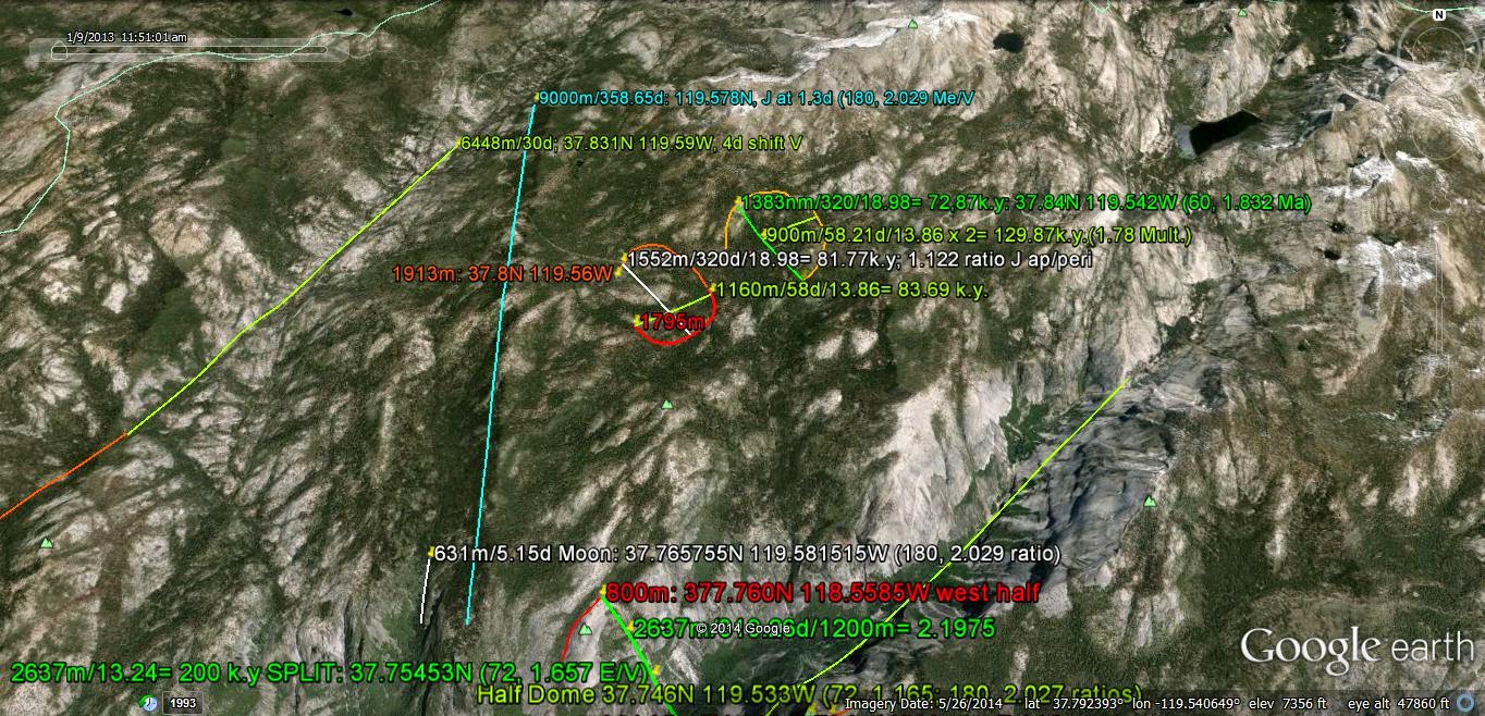
Yosemite DOME has risen rapidly, since the Granitic COMPOSITION resists EROSION:
LARGER AREA:
The original ELLIPSE of the FULL ELLIPTICAL DOME has been EXTENDED and split, over a TIME INTERVAL of 200 k.y. (a fifth of m.y.), and the various RATIOS of events are approximately 100 to 1 to 1/5, for SCALES of 1000:10:2!  Earth displays 40,000 km (circumference), 4,000 (continents' diameters), and 800 (Colorado Plateau), down to 1 meter OUTCROPS. TIMES are approximately 4 b.y., 1 b.y.(Grand Canyon Great UNCONFORMITY), 500 m.y.(Burgess Shale), 250 m.y. (Appalachian Orogeny), 40 m.y.(Colorado Plateau), 25 (Basin and Range), 16 (Columbia Flood Basalts), 4 (Byam Martin NW Passage), and 1 m.y. for the Mississippi River N-S slice.
CALCULATIONS with the NW-SE extension of the Valley (opening the Yosemite Valley), yields a 200 k.y. TIME INTERVAL for the SPREAD of the Ellipse, to open the valley until NOW! This is NOT the age of the Granite (93 m.y.), the time of the Uplift ( 1 m.y.+), nor the Time interval to initiate the entire process, after deposition! It is twice, or 2 x Milankovitch's ELLIPTICAL CYCLE of 100 k.y. This entails 2 elliptical rotations, and you can see the two facing SE-ward towards Half Dome:
The RATIO of 2.16 for Moon/Sun is still being CATALOGUED! Above the ratio is within 2% at 2.19, for this DIAGONAL for the LINEAR Slice of the Yosemite Valley.
WIDE VIEW:

NOTE, regarding Rock VISCOSITY:
 Rock, such as brittle Granite in the shallow Crust of the Earth, has viscosity (or shearing resistance) of 10exp+10 centipoises, or 10 billion times water, with the reference 1 centipoise. This compares with the number of seconds in a thousand years- which is: 60 sec/minute x 1440 min/day x 365.24 days/yr. x 1000 years = 3.156 x 10exp+10 (close to pi= 3.1416). This TIME INTERVAL is the time noticed for events, such as Mima Mounds, to rise in a noticeable fashion! Mounds, when small, are expected to have significantly less viscosity, than Granite, and may rotate and rise on the YEARLY SCALE. Yosemite granite can be expected to exfoliate and spall on the 1000 year scale. The SLICE through Yosemite has taken 200,000 years (more than sufficient to completely shear the original Brittle Granite).
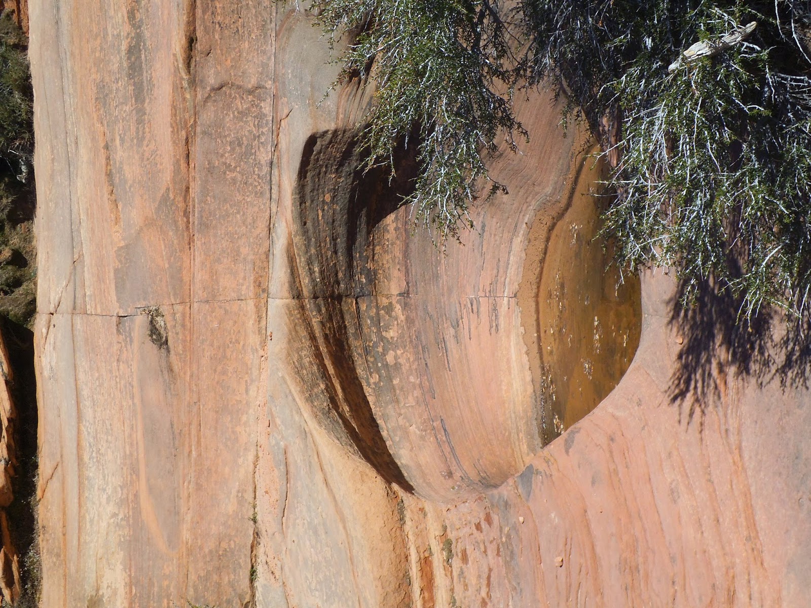
There are SUBTLE Figure 8s, bordering on Imagination, so I make several measurements, to see which ones DUPLICATE:
ENLARGING:
The Figure 8 is INCOMPLETE, and the nearby FRACTURES help identify the Solar CYCLES responsible (Jupiter's peri/aphelion= 816,002/740,679.8= 1.1017, Pallas Asteroid I= 34.84d):

The MORE GENERAL case of HOLE-Slice, regardless of SCALE, is shown below for the Slice N-S of a Glacial Kettle:


And a Figure 8 DEVELOPMENT on a one million year Time Interval:


TIME is an Artifice:
Romance, within a Moonlit Clime, fosters Lovers in our Manmade Time,
 To phrase a salubrious emotional Rhyme, in their ever-so-temporary youthful Prime.
Efforts then, being so Effective, are Timely for the Youth’s Objective;
 But to the Sleuthing Time Detective, the span of time is quite DEFECTIVE!

I perceive that the quaint Timely Interval, nevertheless is quite beneficial;
 It marks the revolution of a Solar Round, which formed a Year- the ancients found!
The Month, the Moon, with one Rotation, gave agriculture a firm Foundation.
 And a day, with an Earthly Orbit, gave daylight (and a working to Absorb it).

Although we can see the Sky’s dimension, Lightening and Mass I must also mention;
 Divulging that there is an Indention- Time, which is simply totally Man’s Invention!
Spaced in the Mind’s eye there are Frames, formed by our Emotions, without Names;
 They long reside there, Nature claims, and they determine our Future Fames!

For the Scientist and his present ilk, time is just a Bolt of Colored Silk;
 It runs through Man, like last week’s Milk, yielding an impression, just a Bilk,
Of fundamental Measures for his Science, Upon which he must place a great Reliance.
 Consequently, for all of his Clients, they must indicate a great Compliance!
           
                                                                                      Harold L. Overton


Cool Clear Water, by Bob Nolan, 1936 (of a Man and his Mule)

I rise at Dawn, and stretch and yawn, and carry on, for Water; cool, clear water.
All day I face the barren Waste, without a Taste, of Water- cool water;
Keep a movin’ Dan, don’t you listen to him Dan; he’s a devil not a man, and he’ll stretch the burning sand with water.
Ol’ Dan and I, with throats burned dry, and Souls that cry, for water- cool water!
Oh Dan, can’t you see, that big green tree, with the water running free, and it’s waiting there for you and me?

I ride and sweat, having not yet et, remaining wet (salt water);
But a date palm lunch, and you a Rare bunch- of green Fodder,
Is more than a Mirage, a further barrage, for Dan (Plodder)!
Now I must get a drink, or else you will think I’m a Nodder.

Th' Nights are Cool, and I'm No Fool, but me'n Mule crave Water- cool Water;
Oh Dan, can’t you see that big green tree, with the water running free, and it’s waiting there for you and me? Cool, Clear, Water.
Keep a movin’ Dan, don’t you listen to him Dan; he’s a devil not a man, and he’ll stretch the burning sand with water.
Ol’ Dan and I, with throats burned dry, and Souls that cry, for water- cool, clear water!

Monday, September 1, 2014

DYNAMICS of the Earth is dominated by the Movements of the Moon, Sun, and Venus in their Elliptical ORBITS in Space; other Planets contribute with Minor Rotation and SHEAR, as they make Inclination Angles, or Tilt, to the Ecliptic Plane. These Gravitational Attractions create UPLIFTS, when the Sun and Planet are in Opposition, and Basins whenever there is CONJUNCTION, effecting Figure 8 PATTERNS on Earth (analemma configurations) in the Crust.

All Major Planets have an INCLINATION to the Ecliptic Plane of less than 4 degrees; Venus exhibits the LARGEST, with 3.39 degrees. Larger Inclinations occur with ASTEROIDS, and the Moon has a 5.145 degree TILT. The Sun has a 7.2 degree Tilt, which Precessses in a 80+ million year CYCLE. Mercury is a minor Planet, with 7d Inclination, and is in a separate Category, due to its being locked into a 3 Rotations/2 Orbits around the Sun (it has 88 days Orbit, and a 1/4.15 ratio to Earth). Additionally, Mercury Orbits eccentrically about the Sun, being sufficiently CLOSE that it is SUBJECT to the Warp of SPACETIME! This doen NOT EXPLAIN Pluto, which has 17 degrees Inclination and is furthest compared to the Large Planets! This will be EXPLORED in another rendition.
NOTE, here is a VISUAL METHOD that you can use to compare EARTH TIDES to Ocean Tides, by watching the coming and going of SALT WATER, as it oscillates at the Beach while you fish for Salmon:
Starting with the Full Moon, where the Moon and Sun are on OPPOSITE Sides of the Earth, note that there are 2 MAXIMUM Ocean TIDES Daily. At FULL Moon time, at 9pm (Moon is completely ROUND, since the exactly opposite Sun shines on it with NO interference from Earth Blockage, except for an Eclipse), the Maximum Moon high tide occurs (called OPPOSITION of Sun and Moon). Within a few hours, the ocean will have advanced to your Beach Position at its Highest Elevation! Time is allowed for the DELAY in reaching your fishing spot, because of constrictions in the PATH (such as narrow inlets).

12 hours of Elevation CHANGE, from the lowest level, comparing Moon High Tide to Sun High Tide, will effect 2.16 times as much Height change, since this is the RATIO of Moon’s GRAVITATIONAL ATTRACTION compared to the Sun’s.  This is related to the Mathematical Relation: Force= a Constant x Mass of a Solar Body/(separation distance) squared, and while our Moon is much smaller than the Sun, it is MUCH CLOSER!
At 9pm, two weeks later there is a New Moon, and the Moon and Sun will be at CONJUNCTION (both on the same side of Earth), and the Combined ATTRACTION will be on the opposite side of the Earth from you. This results in a LOW TIDE, since the earth has pulled inwardly from you. This is called a depression, basin, or SINK (in Earth Tides).
SIMILARLY to Ocean Tides, but much smaller, are EARTH TIDES' movements. These create RISES and SINKS with MAGNITUDES of the Viscosity RATIO of Rock/water, which is LARGE! The resulting magnitudes are near millimeters yearly, for Rock, compared to meters 4 times-daily for water (4 x 365 days x 1000 mm/meter yields a 1,460,960 ratio).
Between Highest and Lowest TIDES for the period between Full and New Moon, the Moon follows a PATH, which is somewhat adjacent to the Earth’s, and the result is SHEAR, forming CIRCULAR or Arcuate designs on the Rocks- a Partial Figure 8 (ANALEMMA).
TIDE Table CALCULATIONS:
 Tidal oscillations shown on tables are made from Historical RECORDS, since Local INTERFERENCE determines local Tide BEHAVIOR! The case of Key West is selected, September 2014, to avoid the Geometry of Bays, Constrictions, and channels.
 Key West, FL, is surrounded by sea water and has less unknown influence of local GEOMETRY. Comparisons are made for 3 situations:
1.     Full Moon, where the Sun and Moon are exerting Maximum ATTRACTION on 9 September;
2.     The LOW of the intervening cycle, between Full and New Moon, exhibited on 17 September; and,
3.     New Moon, where the Sun and Moon have additive Force on the side of Earth facing the 2 bodies, on 23 September/2014.

ANALYSIS finds that:
a. the Full Moon has Maximum Spread of .64 meters, compared to the Sun spread of .54m;
b. New Moon has .43 and .44m Spread, or NO difference between Moon and Sun Sinusoidal Cycle height (base to top);


An ANALEMMA is diagrammed and MEASURED, below, in relation to the TIME of the year; this can be calculated for a RATIO of the LOWER/UPPER blocks. Moon/Sun = 2.16, from Google Earth CALCULATIONS:

Below is a photo of Venus, showing LARGE and small Figure 8s on its SURFACE:

COLOR CODE is as follows: red, for COMPRESSION or Rising; blue for EXTENSION or Sinking; black for FACTUAL Information; Pink for scenarios; yellow for location or OUTCROPS; green for measurement, and white for N-S linears.

 An ANALEMMA is the PATH exhibited by the ORBIT of one Solar mass (Body, Planet or Asteroid) around another in an ORBITAL year.
 CYCLES of the Sun (or Moon) inflict a DIFFERENTIAL ATTRACTION for localized parts of the Earth's Crust, whenever the Sun and another Solar Body are in OPPOSITION (on opposite sides of the Earth). The size of the Region is determined by Mass/(Earth to Body separation) squared. When they are in CONJUNCTION, there is the INVERSE- SINKS or Basins are created along-side the Rise created by OPPOSITION of Sun and another Planet to Earth! These side-by-side ELLIPSES form a Partial Figure 8, or INCOMPLETE Analemma, such as:
Oak and Crescent HARBORS, WA State, where Maylor Point is a "TIT" between 2 sets of Figures 8. Notice that Oak Harbor (left Bay) exhibits a Forward "S", indicating that it is RISING. Drive on Pioneer Street, and you will see how it is rapidly filling, compared to Crescent Harbor:
Rates and Time of DEVELOPMENT of the ROTATIONS are shown below:


 Inclination is shown in GREEN, for the below DIAGRAM:


COLOR CODE is as follows: red, for COMPRESSION or Rising; blue for EXTENSION or Sinking; black for FACTUAL Information; Pink for scenarios; yellow for location or OUTCROPS; green for measurement, and white for N-S linears.
 An ANALEMMA is the PATH exhibited by the ORBIT of one Solar mass (Body, Planet or Asteroid) around another in an ORBITAL year.
The ANALEMMA, or Partial Figure 8, occurs on many SCALES, from 1 millionth, in WA Skagit  County Mt. Erie Quarry, below, to Continental SIZE:

Figure 8, above, is shown below UN-INSCRIBED; the Precessional portion is disected by a DIVIDER, creating the beginning of another ELLIPSE below it. The iron-stained "S" is an OLDER Partial Figure 8:
Below is a collection of VERTICAL Figure 8s, showing that they occurred in the SUBSURFACE, before being recently exhumed by artificial means, or by SPALLING, Landslides, or Shearing:


Almost every SCARP has arcuate Fractures (consisting of MANY small adjacent straught slices or LINEARS):

The BEGINNING of a Figure 8 is a "HOLE" which is sliced  by a FRACTURE; later, it enlarges to form 2 arcs- one of which enlarges by EROSION more than the other (forming an ELLIPSE with 2 FOCI, or 2 circular cells with unequal DIAMETERS) yielding a RATIO denoting the Solar Mass which formed it (Venus would yield 1.62 in relation to earth, where Earth days per year/Venus Orbit's days= 1.62:


Viewing at Right Angles
Zion Virgin River exhibits a Partial Figure 8 near the end of the Paved Road, where a SLICE cuts a "HOLE":

Shnabkaib TRAPEZOID exhibits a Subtle Figure 8, or Partial ANALEMMA:
Further West, in the Basin and Range REGION, the development of a million year Figure 8 occurs:

"JERKS" of Variable DIAMETER Arcs, indicate the INTERVAL TIME by:
Time= Diameter/16.24 mm/year, IF expanding to the South, or D/17.48m, if to the North:
Above COMPARES with the Plate Theory, where the size of the plate must be MINISCULE! It is HOPELESS to continue with the Plate Theory ASSERTION, and it should be DISCARDED! Gravitational Rotational SHEAR should take its place.
A canyon in the Basin and Range is ERODING, downward (SINKING):
A rotating SHEAR circle can be seen in this SCARP; the narrow end (arrow-shaped) of the Upper part informs us that the rotation is CCW.  Since the VERTICAL is PERPENDICULAR to the LATERAL (indicating CW), this means that the Bluff is now sinking. This is NOT INTUITIVE, and relates that EROSION is greater than UPLIFT!
Note the Laterally EXPANDING Figure 8 below, bordered by a SLICE to the West (right):
A Hand Sample, on the 1 millionth SCALE, EXHIBITS all of the important features: an AXIAL Cycle to the left, a Precessional Cycle to the right, a DIVIDER between them (which diverts to the right, before allowing continuation of the Axial Rotation to completion:

The SLICE is more clearly shown, for a Figure 8 which has fallen from a PINNACLE above the Zion Watchman Trail:
Hurricane FAULT, Hf, and the Honeymoon Trail SPIRAL:
SIZE INCREASE is shown for LARGER Partial Figure 8s, or ANALEMMAS!

Missisippi River Delta illustrates OVERLAP of the Axial and Precessional ELLIPSES; note the Orientation of 27.5 degrees from N-S (should be corrected to 30d, by visual inspection of the white cross), which is scribed by an ASTEROID, with Pallas of 34 degrees as the Usual Suspect! A partial Figure 8 can be seen extending into Louisana (rivers occur above Shearing ARCS, and Red River forms below the incomplete portion):

The LARGEST Feature possible to view is a CONTINENT, on 2D Google Earth:
The Compass ANGLE of 82.94d, from the West (youngest) is 7.06 degrees from a Latitude Parallel, and this is near the 7.2d Sun Line separation (2% difference), and shows my ERROR of measurement! The 40 degree compass angle SHIFT at Juan de Fuca DIVIDER is the start of the LARGER part of the Figure 8; more ragged is the INDENT at the Trailing Edge of the West TIDAL MOVEMENT at New Jersey! Note the separation of North America into 2 arcs at JdF.
 You should ask: "Why is Mercury, with its 7.0056d Inclination NOT INVOKED to correlate with the 7.06 degree difference from the 90 degree Latitude Parallel"? It has ONLY a .0544d Difference, or less than 1% deviation! The answer is: Mercury has INSUFFICIENT MASS (3.3 x10exp23 kg, or .055 x Earth mass) to Lift a Continent! Only the Moon, Sun, or Venus is sufficiently close or has the Mass for this Gravitational UPLIFT! Further, Mercury is close to the Sun, with its WARP of SPACETIME, and has PRECESSION of the Perihelion (closest separation) about the Sun!

The FOCI of the two halves of the Figure 8 for North America (Canada and USA Orbs), are predicted to be in the Hudson Bay (OLDEST), and the Colorado Plateau San Juan Mt. Uplift:
The SEPARATION of the San Juan Mt. from this TENTATIVE FOCUS, at Red Cloud Peak, with 4277m Elevation:
Red Cloud peak is likely the FOCUS of the 555 k.y. develpment (5 Milankovitch CYCLES), and it is one of the HIGHEST and YOUNGEST Peaks in the vicinity of the Colorado Plateau CENTER of UPLIFT. The SEPARATION is 2980 km, with an estimated INTERVAL TIME of 125 m.y. This "FITS" the Binary Theorem, but is the FIRST TRIAL for determining the FOCUS of the USA Orb (as compared to the OLDER Canadian ORB):
Although Hudson Bay was instituted in PreCambrian times, it has EXTENDED since 57 m.y. (likely 64 m.y. by the Binary Theorem). Its AGE since it became the FOCUS of the Canadian CRATON is much OLDER, calculating near 256 m.y. (the AGE of the Split of Africa from Qsna)!

There are TALLER Peaks in the Colorado Plateau, which introduces UNCERTAINTY. But this may be due to Softer BASEMENT Rocks:
The SECOND TRIAL measures 3112.75 km, from Hudson Bay 90W, to Uncompahgre Peak, the tallest in the vicinity:
The COMPASS ANGLE from Hudson Bay is 230.75 degrees, which is (270- 39.25)d, or near 40 degrees from a Latitude Parallel.  This is 180/40= 4.5 ratio, which "FITS" the Binary relationship. Taking an angle of 40 degrees from Uncompahgree Peak allows a "homing in" on the correct FOCUS at the James Bay Craton focus, of 2750 km/40d:
If this ANALYSIS is correct, James Bay reflects the latest Focal Point of the Canadian Orb, and the OLDER focus at Hudson Bay has ben superceded by the 13.272 m.y. SLICE:
Above is the correct PROGRESSSION, of a slice proceeding from the ancient "HOLE" of Hudson Bay, correlating with Miocene UPLIFT of the San Juan Mountains via EXTRUSIONS.