SUMMARY:
The Colorado River is young, according to visual aspects: the sheer drop of its canyon walls and the narrowness of the channel attest to its youthfulness. Its trace through time can be noticed as far to the NE as the Little Colorado. Arcs of the river and their diameters allow the various times of development to be calculated. Finally, the most narrow and most shear walls allow the “breakthrough” time or AGE to be measured:

ALTHOUGH ONE ANALYSIS, TAKEN AT RANDOM- MAINLY FOR ITS SHEER WALLS AND PARALLEL GRID LINES- INDICATES THAT THERE HAS BEEN ONLY 70 K.Y. SINCE THE RIVER DEVELOPED THESE FEATURES, THERE ARE OLDER ONES WHICH ARE NOT SO PRONOUNCED. THIS INDICATES THAT THE RIVER WAS MORE GRADUALLY FORMING BEFORE THE LAST "MILANKOVITCH 100 K.Y. ELLIPTICAL CYCLE". PRIOR, THE RIVER WAS MORE EROSIVE, WITH NORMAL EROSION. WHAT HAPPENED AT THE 100 K.Y. TO ELTANIN 2.15 M.Y. INTERVAL?


Following the LARAMIDE REVOLUTION of 64 million year age, and the 40 m.y., event, vulcanism was initiated in the Taos-Rio Grande Valley (LLANO QUEMADO). The earliest extrusion was 41m.y. and this progressed clockwise, CW, around the edge of the rising Colorado Plateau, CP. Simultaneously, CP rotated CCW, with drainage shown in the first great arcuate feature near Page, AZ:

BELOW, A PHOTO IS ENLARGED TO VIEW THE COLORADO RIVER NEAR THE KAIBAB UPLIFT AND JACOB LAKE. THIS ANALYSIS FINDS THAT THE NET TIDAL WEST SHOVE OF THE PLATEAU IS NOT REDUCED- BUT INCREASED: 30 VS 20 MM/YEAR. THIS HAS HAPPENED IN ANOTHER ANALYSIS, AND IS RARE; OUT OF 100 CASE STUDIES, ONLY MARIANAS (GUAM ISLAND) HAVE HAD THIS MAGNITUDE TIDAL SHOVE (I HAVE SINCE FOUND THAT THE LUNAR TIDES ARE 20.48 KM/M.Y. AND THE SOLAR OFFSETS THIS IN THE WESTERN HEMISPHERE BY 10.24= 10.24 KM/M.Y. NET. IN THE EASTERN HEMISPHERE THE EFFECT IS TO ADD TO THE LUNAR TIDES RESULTING IN 30.72 KM/M.Y.) REMEMBER THAT THE MARIANAS TRENCH IS THE DEEPEST TRENCH, WITH A DEPTH OF NEAR 35,000 FEET. NOW, HERE WE HAVE AN UPLIFT OF THE KAIBAB WITH THE YOUNGEST AND MOST SHEAR CANYON DISPLAYING A SIMILAR CIRCUMSTANCE. THIS WILL REQUIRE "BORING IN" ON A NEW AREA OF ANALYSIS:

CONTINUING, THE ARC ANALYSIS FOR AGE OF SHEAR FEATURES INDICATES THAT THE PORTION OF THE RIVERS NEAR THE EDGE OF THE KAIBAB UPLIFT HAS "CHATTER" DUE TO COMPRESSION OF THE CRUST. CHATTER RESULTS IN COMPRESSION WITH FOLDING, THRUSTING, AND REVERSE FAULTING. THIS RESULTS IN INCREASED SPIN RATE OF THE EARTH, ENOUGH TO OFFSET SOME OF THE TIDAL FRICTION FROM THE MOON. THE END RESULT IS A NET LESSENING OF EARTH TIDES WITH COMPRESSION (OPPOSITE TO NET INCREASE OF EARTH TIDES WITH EXPANSION OR EXTENSION, WHEN ELLIPTICAL ELONGATION OF THE EARTH'S REVOLUTION ABOUT THE SUN IS INCREASED- THE PLANET VENUS SEEMS TO CREATE AN IMPORTANT PART OF THIS CHANGE IN EARTH TIDES' MAGNITUDE; YOU REMEMBEFR THE RELATIVE ARANGEMENT OF GRAVITATIOINAL CHANGES BY THE SIZE OF THE OBJECT IN SPACE INVOLVED: MOON, SUN, VENUS, PROBABLY JUPITER NEXT, AND I WILL CALCULATE THE INFLUENCE OF OTHER PLANETS):
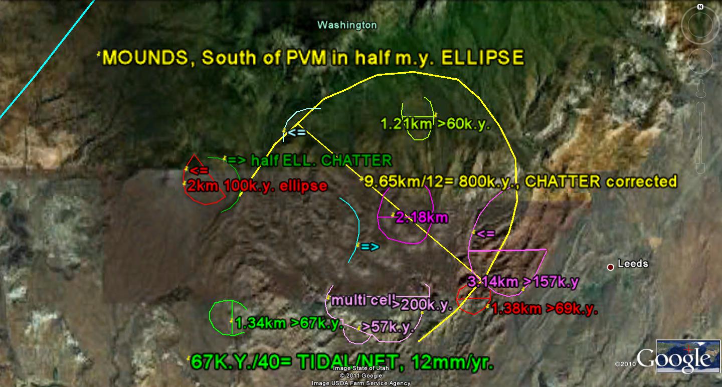
 NOTE: WHEN THE EARTH IS ATTRACTED BY GRAVITATION FORCES WITH ALIGNMENT OF THE LARGE PLANETS, IT ELONGATES ITS PATH IN AN ELLIPTICAL CONFIGURATION. THIS SLOWS ITS SPIN RATE, EXPANDS ITS DIAMETER (BULGING), AND CREATES GRABENS INTO WHICH THE WIDENING CRUSTS SINKS. THIS RESULTS IN AN INCREASE OF WEST EARTH TIDES, SINCE THE STEADY ATTRACTION FROM THE MOON BECOMES MORE IMPORTANT. CONVERSELY, WHEN THERE IS COMPRESSION- AS WITH SOME OTHER PLANETS, PUSH DOWN OF THE CRUST BY THE ICE AGE, AND "SQUEEZING" UPWARD OF THE KAIBAB UPLIFT, THERE IS AN ACCELERATION OF THE EARTH'S SPIN RATE, MINIMIZATION OF LUNAR EARTH TIDES, AND NET TIDES GREATER THAN 20MM.YR.
THE COLORADO RIVER MUST SURMOUNT THE KAIBAB PLATEAU, WHICH IS HIGHER IN ELEVATION AND HAS AN AGE GREATER THAN THE RIVER'S "BREAKTHROUGH". THIS PLATEAU STARTED RISING IN THE MIOCENE, AND CONSTITUTED A BARRIER FOR THE RIVER; THE PATH AWAITED THE INCISION OF THE PLATEAU BY LATER SHEAR-ROTATIONS- IN THIS CASE LESS THAN THE 6 M.Y. SHOWN IN ITS TRACE TO THE NE. INDICATIONS ARE THAT IT DRAINED, ALONG WITH THE LITTLE COLORADO, TO THE NORTH PREVIOUSLY (THERE WAS A CW SINK NEAR THE UT BORDER AT THE TIME). BELOW IS THE TRACE FOR THE UPLIFTING KAIBAB PLATEAU:

TURNS IN THE RIVER OCCUR WITH CONCOMITANT ROTATIONS ACCORDING TO THE "BINARY THEOREM":