Wednesday, February 17, 2010

Divergence of two Great Coriolis Cells creates vulcanism at the separation location (TRIANGLE OF DIVERGENCE)


THE WASATCH LINE AND THE HURRICANE FAULT CANNOT BE DISTINGUISHED ALONG MOST OF THEIR COMMON PATH. However, whenever Hf departs FROM the Great Basin and Range, B&R, fault (which is the same as the Wasatch line in this location) vulcanism emerges in the opening or separation of the two entities. This separation occurs at the Black Ridge area near Anderson Junction of the freeway I-15. This Hiway and the B&R lateral rotation exists in a saddle, which is the mark of faulting. When the lateral faulting turns to the SW toward ST. George, it departs Hf, and there is extension of the CRUST- ALLOWING EXTRUSION OF BASALTS (mainly vents, but the Pine Valley Mountains is an expression of the same feature- extension allowing intrusion).
BELOW IS A SIMPLIFIED MODEL FOR THE MOVEMENTS OCCURRING ALONG THE HURRICANE FAULT, Hf, IN THE VICINITY OF THE TOWN OF HURRICANE- which is an introduction to movements in the local area:
A photo is shown below, exhibiting the main directions of movement in the I-15 freeway area. Vents occur not only near the Anderson Junction, but along the Clock-wise rotation under the Virgin River (the Grass Valley extrusions lie to the south of this divergence): The case of Hawaii- shown at the top introduction- took a bit more time to completely de-cipher, since the geology culture has published so much literature that the true nature is overwhelmed by large budgets, speculation about “hotspots“, plate theory, and hand-waving. With my third try, I finally found the relationship, by RESORTING TO ANALYSIS OF THE SMALLEST CORIOLIS DIVERGENCE- THAT EXISTING JUST OUTSIDE MY WINDOW- looking east toward the Hurricane fault. I have found that this is the location to investigate everything one needs to know about CORIOLIS CELLS, VULCANISM, GREAT FAULT MOVEMENTS, SHEAR ALONG CIRCULAR PATHS: HOT SPRINGS, ZONES OF BETTER-THAN-AVERAGE PERMEABILITY OF AQUIFERS, FRACTURE PATTERNS, UPLIFT, TILTING OF SEDIMENTARY BEDS, SHALLOW METAMORPHISM AND HEAT OF BRITTLE FRICTION.
THE CASE FOR YELLOWSTONE RHYOLITIC VULCANISM IS INTRODUCED VIA A PLOT OF THE PROGRESSION OF THE EXTRUSIONS WITH TIME (ALTOGETHER ABOUT 13 MILLION YEARS, FOR 13 SITES OF EXTRUSION IN IDAHO AND NEVADA-UTAH). THESE MOVE TO THE ENE WITH GEOLOGIC TIME, AND EACH IS AT THE NORTH OF A NEW VALLEY IN THE BASIN AND RANGE (WHICH ALSO NUMBER 13-14 DIFFERENT BASINS).
YELLOWSTONE GEOTHERMAL AREA:
IT SEEMS FAIRLY CERTAIN THAT THE MOVEMENT OF THE SIERRAS TO THE WEST CREATES EXTENSION OF THE B&R, AND OPENS A LARGE FRACTURE OR LATERAL FAULT IN THE LOWER CRUST WHICH ALLOWS THE MANTLE BELOW TO EXTRUDE THROUGH THE SILICEOUS CRUST.


The case of Yellowstone is essentially the same AS THAT FOR THE SMALLER VENTS AND EXTRUSIONS- a divergence of the crust, creating large-scale extension and fracturing, at the more complicated boundary of the northern edge of the EQUATORIAL BULGE, EB, and the westward tidal shove of the Sierras- which opens the B&R to extension (creating the B&R in the process). This is treated in an earlier blog, which can be found under Yellowstone analysis. The zone north of B&R is one with no bulge- hence it moves relatively to the east compared to the Sierras westward shove.
I am also presenting the opposite case- that of two converging Coriolis cells- where there is a Geothermal Anomaly, but one of marginal HEAT (T< 300F). THIS IS AN ANALYSIS done for DOE BY MYSELF IN THE 7O'S. This was drilled for hothouse use, for tomatoes, etc. which was insufficient for electrical power:

Notice that the chemical composition of the produced hot water yields information about the direction of movement and of the orientation of the anomaly:
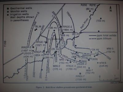
I will try to discern why the higher elevation mountain chain to the east is rotating CW (sinking, and this could be the case for rapidly-eroding mountains). It is likely (as shown by the local drainage pattern coming off both chains of mountains) that the chain to the east is rotating faster- thereby creating HEAT OF FRICTION.

THIS IS TO BE CONTINUED, LIKE ALL THE OTHERS, SINCE EVERYTHING IS CONNECTED TO EVERYTHING ELSE, AND I GET MORE ACCURATE RESULTS AS I ANALYZE MORE CASES.

Tuesday, February 16, 2010

Deccan traps erupted as Chicxulub reaction Bulge Fractured and forced the SUBCONTINENT northward, from 90E, 22S Latitude

EARTH SCIENCE postings from www.googleearth.com are reported in blogsites in: www.PorOgle.blogspot.com for other locations.
Deccan traps were erupted along the coast, in a circular configuration in the southern part of India. This strongly hints that there has been a CCW rotation by Coriolis forces since the initiation:


NOTICE THE INFLECTION POINT, OF A RE-ORIENTATION OF AT LEAST 30 DEGREES- OF TRANSFORMS IN THE INDIAN OCEAN, JUST BELOW THE 90E RIDGE (THE PATH OF THE SUBCONTINENT, BEFORE COLLISION TO FORM THE HIMALAYAS):

As conjectured in the below diagram, the crater of the CHICXULUB asteroid strike effected a bulge antipodal to the Yucatan 22N, 89W Longitude location (Merida, Mexico). As shown, the uplift would have fractured the edges of the subcontinent drastically, allowing outpouring of basalt, which originated at a depth where it would have been hot and plastic at its pre-strike condition.


BEARING ON THIS IS THE PATH OF THE INDIAN SUBCONTINENT, BEFORE THE KT STRIKE. SOUTH AFRICA (WHICH WAS SIMILARLY MOVED IN MESOZOIC TIME) SHOWS THAT THIS PATH WAS TO THE NE, CREATING A CCW ROTATION OF THIS PORTION OF AFRICA. THIS MAY BE SEEN ON A GEOMAGNETIC MODEL, AS DUE TO THE IMBALANCE OF MASS DISTRIBUTION OF THE EARTH (BECAUSE OF ALL THE BULGES ON THE NON-SPHERICAL GLOBE):
Continuing, the rotation of South Africa is found to be adjacent to the most southerly of the great rift lakes- indicating that the rotation is moving the land mass to the west, creating the rift by extending the crust. Hence the extension was post-Chicxulub, because movements were to the NE before the collision: Diatremes and other extrusions are shown below:
THE ONLY CLUES FOUND FROM A STUDY OF CHICXULUB, FOR COMPARISON WITH THE SUBCONTINENT SITE (FOR INFORMATION ABOUT POSSIBLE INVOLVEMENT WITH OTHER ASTEROID STRIKES ARE SEEN IN THE FOLLOWING DESTERRADA ISLAND CIRCULAR DEVELOPMENTS)


This is being continued, as I get evidence for the greater mass extinctions from the Permian die-off. See this in another blog submission at this site.

Sunday, February 14, 2010

WESTERN USA TRIPLET: BASIN AND RANGE, COLORADO PLATEAU, AND THE SIERRAS

EARTH SCIENCE postings from www.googleearth.com are reported in blogsites in: www.PorOgle.blogspot.com for other locations.
WESTERN USA TRIPLET: BASIN AND RANGE, COLORADO PLATEAU, AND THE SIERRAS
It all began with the shallow Cretaceous seas, where an extensive layer of silts and shales was deposited.
This acted as a thermal blanket for the HEAT FROM RADIOACIVITY, which was to arrive during the Tertiary. Deposits of radioactive logs, shale, and borders of oilfields attest to an unusual amount of K, Th, and U in the
Colorado Plateau, CP, in Ambrosia Lake, NM and other areas near basaltic vents and extrusions throughout the area.
The region of the TRIPLET includes the states of the 4 corners- AZ, CO, NM, and UT- as well as the Basin and Range, B&R, of NV, and its bordering state CA.


After the collision-forming Laramide Revolution, the lowlands of the west USA began to heat from radioactivity (noticed from high geothermal gradients in oil wells- 1.6 degrees F/hundred feet, compared to 1.0 in large basins in Texas). This created thermal expansion of the Crust, specifically the CP. The rise of CP was a movement which the Coriolis Force could act upon, and CP began to rotate counter-clockwise, CCW. This may be noticed by the CW occurrence of basaltic vents starting in the Rio Grande rift and proceeding around the perimeter of CP to St, George UT now. The B&R is also rotating, but in the CW motion, particularly noticed on the east (the WASATCH LINE) and south sides to the Valley of Fire, NV.
As noticed in the MODEL, the B&R is sinking (it is a closed basin), while the CP is rising- both on the order of 1 mm/year, as noticed by GPS readings at Fredonia and by my calculations from diagonal slickensides. With counter-current rotation, there is no brittle friction, except at locations where divergence of faulting occurs- such as at the Black Ridge and Hurricane UT areas, where many basaltic vents lie dormant. This might be interpreted as a vertical rotation, where the thick crust of the CP moves side-by-side with B&R, allowing high density limestone (with its thin crust) to equilibrate with low density silicates of thicker column. There is also a ion and re-mineralization occurring, where K emerges while Na disappears from surface waters, and phase changes occur. This is shown for a log of drill cuttings from a geothermal area in Kizildere, Turkey (close to Pamukkale hot bathe area)

Here is the sequence so far:
a. CP rises, and B&R sinks, creating the WASATCH LINE.
b. CP rotates CCW, while B&R spins oppositely- CW;
c. The Earth contracts continually, due to slowing from tidal friction with the moon, and the shrinking creates lateral compression to form the Sierras uplift, post-Laramide and post CHICXULUB;
d. Tidal friction drags the Sierras westward (relative to normal slowing of lowlands) and the transforms from the CA coast to Midway and the HI chain develop. There is no vulcanism in this latitude band, short of the chain, since there is no subduction in this 36-40N band;
e. Sierras’ movement to the west creates extension in B&R, terminating at the Wasatch Line and CP. Simultaneously for the 13 major basins in UT and NV, there are 13 rhyolite sites to the north- each of which extrude violent Yellowstone type eruptions;
f. The rhyolite extrusions proceed eastward with time, because of the continual stretching of B&R, and the extension can proceed no further eastward, because of the westward shove of the Rockies (under the impetus of tidal friction also, but lesser than that of the Sierras, due to lower elevations of the peaks generally- compared to the highest Whitney elevation);
g. The Sierras continue to move to the west, creating the Garlock fault and the 40N transform at Mendocino, and,
h. The Sierras rotate vertically, creating a sinking Central Valley and heat for intrusives on the west side and metamorphic rocks on the east of Yosemite NP.