IN THE PUGET SOUND AREA, NEAR THE COAST, A RARE GOLDEN PAINTBRUSH GROWS; THIS IS ONLY FOUND IN The NW, AND APPEARS TO BE ASSOCIATED WITH THE MIMA MOUNDS. SIMILARLY, THE MORE COMMON BLUE CAMAS HAS AN ASSOCIATION ALSO; IT APPEARS TO "LIKE" SOME SOIL CONSITUENT- SUCH AS LOCO WEED (ASTRAGALUS) DOES WITH SELENIUM, BUT I AM WAITNG FOR AN EAGER BOTANIST OR SOIL SCIENTIST TO DETERINE THE MINERAL AND CONCENTRATION REQUIRED (ppm of gadolinium?). I ANTICIPATE THAT, SIMILAR TO IRIDIUM BEING FOUND IN ASSOCIATION WITH KT- THE DINOSAUR EXTINCTION, SOME OTHER RARE MINERAL WAS PRODUCED BY THE GRAVITATIONAL FRAGMENTATION (ICE AGE) OF PUGET SOUND. THIS MINERAL WILL BE A CLUE TO THE INFLUENCE OF GRAVITATIONAL DESTRUCTION (EXTINCTION) ON THE "DISTINCTION" OF NEW LIFE. ANOTHER SUCH DISTINCTION IS THE BURGESS SHALE, WHERE NEW FORMS EMERGED BETWEEN DESTRUCTIVE EVENTS. I PREDICT THAT PROTEIN IS INTRODUCED IN THESE INTERIMS FROM STONEY CHONDRITES, AND THIS IS ABSORBED BY THE OLD LIFE TO YIELD NEW EXPERIMENTAL FORMS OF LIFE. I WILL REPORT ON THIS SUBSEQUENTLY, ALONG WITH THE FIGURE 8 ARRANGEMENT OF VEGETATION ON THE SANDS OF SAND MOUNTAIN, UT- WHERE THE NORMALLY-OBSCURED PATTERNS OF LIFE ARE THERE FOR ALL TO VIEW. IN THE MEANTIME, YOU "ARMCHAIR" BOTANISTS START WORKING ON THIS TREMENDOUSLY EXCITING FIND!


NEAR MY SUMMER HOME ON WHIDBEY ISLAND, THERE OCCUR MIMA MOUNDS- NEAR THE COAST, AS SHOWN ON THE FOLLOWING ELLIPTICAL SCARP AND TERRACED HILLSIDE; THEY FORM A RISE, WHICH IS HALF OF THE NORMAL DIAMETER- FORMED BY THE SUN OFFSETTING PART OF THE LUNAR TIDES:

THE EARLIEST OBVIOUS EXAMPLES of LIFE being influenced by the wave nature of Gravity is that of the formation of MIMA MOUNDS. Photo below shows how the rotation and shear of these rises in DIFFFRACTION PATTERNS result in a proliferation of wildflowers on the edges of the mounds. Evidently, the continual shear creates paths for water and roots. The patterns are shown in Puget Sound as beautiful underwater diffraction arcs:
The mounds become enlarged with TIME, and effect an elliptical pattern- as seen for CHECKERBOARD MESA UT, Zion NP:
AFTER FINDING THAT LIFE RESPONDS TO THE ELLIPTICAL CIRCULATION OF GRAVITATION-PRODUCED MOUNDS, I STUMBLED ONTO FRANTICALLY-WORKING ANTS, WHO WERE TRYING TO GET 12-13 ANTHILLS IN PLACE AT THE TIME OF THE NEW MOON (THIS IS HALF WAY TO THE FULL MOON (WHICH HAS 12-13 OCCURRENCES YEARLY):

I WILL POST LATER THE INCREASE OF ANTHILLS WITH TIME (2 MORE WEEKS NECESSARY), TO SHOW WHETHER THE ANTS HAVE DEVELOPED THE INNER CIRCLE OF LARGER ARRAY DIAMETER/SMALLER ARRAY= 1.6, AS FORMED BY THE ACTION OF MOON-SUN YEARLY (AND POSSIBLY MONTHLY, FOR THESE ANTS). THIS WILL SHOW THAT ROTATING SHEAR CIRCLES HAVE BEEN SENSED BY THE ANTS- WHICH WILL AID THEM IN FORMING A CHAMBER TO ESCAPE THE SUMMER HEAT.
BELOW IS A PHOTO FROM 4 DAYS LATER- SHOWING HOW THE "WASATCH LINE" (DIVISOR BETWEEN CW B&R, AND THE CCW ROTATING COLORADO PLATEAU)
SEPARATES THE SMALL CW FROM THE LARGER CCW DEVELOPMENT OF THE MOUNDS. HOW IS THIS RELATED TO ANTS? THEY EXPLOIT THE SMALL SHEAR FRCTURES FORMED BY THE SULLIVAN KNOLL CW ROTATION AS IT COOLS AND SHRINKS (A SINKING MOVEMENT RESULTS IN A CW ROTATION- AS IN HIGH PRESSURE WEATHER CELLS):
THIS MOVEMENT AND DETERMINATION OF "PREFERRED" VEGETAL LOCATIONS IS INFLUENCED BY SHEAR CRACKS- WHERE MOISTURE COLLECTS (ATTRACTING LIFE). BELOW ARE 2 PHOTOS OF PATTERNS OF ARCUATE MOVEMENTS, AND IF YOU ARE INCLINED TO GIVE THIS CONCLUSION AN OBJECTIVE VIEW, YOU CAN SEE CIRCULAR PATTERNS OF VEGETATION IN THIS STARK DESERT ENVIRONMENT:
BEAUTIFUL SCENERY, AND THIS CAN BE ACCESSED ACROSS THE ROAD FROM SAND HOLLOW PARK AND LAKE (AT AN UNLOCKED GATE, WHICH ALLOWS PARKING INSIDE- NOT ON THE SHOULDER OF THE ROAD):
COMPARE THESE WITH THE GLOBAL GPS ROTATION INDICATIONS; THIS IS FRAMED IN TERMS OF CONSISTENT MOVEMENTS (alternate indications from 2 sides of islands have been ignored):
VIEW FLOOD basalts- which are a result of GRAVITATIONAL FRAGMENTATIONS, MAKING WAVES of BASALT (as made in the smaller MIMA MOUNDS). THESE are formed whenever SOLAR OFFSET of LUNAR TIDES CREATE "BUCKLES" or CHATTER. The OVERALL PATTERN is one of DIFFRACTION ARCS- CRISS-CROSSING EACH OTHER.
THESE COLUMNS are formed by SHRINKING, whenever COOLING and ROTATION of the mass forms both LATERAL and VERTICAL FRACTURES:
OTHER FLOOD BASALTS COLUMNS, FROM BC, are shown for COMPARISON:
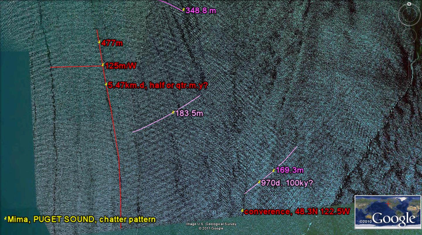
ABOVE IS A SEISMIC-DETERMINED MAP OF WHIDBEY ISLAND, which can be used to check my work (using MILANKOVITCH CYCLES and LATERAL FAULTS from shearing rotations). BELOW is the map at right angles to NORMAL (NORTH is to the left); this can be used to get the BIG PICTURE" of CIRCULAR FEATURES (rather than the inferred straight line faulting, which is the usual interpretation by GEOLOGISTS):
I had to change my outlook, being influenced by GEOLOGICAL DOGMA, to look at the CRUST of the EARTH in a completely ORTHOGONAL VIEW, to get TRUTH, as shown by google earth and DIGITAL PHOTOS of the "DIRT GEOLOGY" (as explained to me by the PRACTICIONERS):

The key to understanding the movements of the EARTH CRUST lies with the finding that MIMA MOUNDS are the initial movement created by "JERKS" of the earth. These later become larger, as the earth erodes along-side them. They are not lifted, but appear to RISE, as they are TWISTED by CCW ROTATION, as the earth REBOUNDS BELOW THEM. Essentially they rise, but it is not noticeable to those nearby, since the REBOUND is on a large enough scale that the terrain appears unchanged. Notice in the photo below that for this REBOUNDING, UNLOADING, SHEARING, ROTATING, and SOLAR OFFSETTING of LUNAR TIDES, that GRAVITATIONAL INFLUENCE is turning the direction of shear in 3800 years. I have been trying to determine the scale of TIMED MOVEMENT of the Mounds and their larger relatives (such as the CHECKERBOARD MESA in ZION NP, UT), and here it lies on the island where I live. The rotation of mounds is significnt enough for VEGETATION to profit from the micro-fractures, and we can enjoy the blossoms (such as EDIBLE CAMAS and GOLDEN PAINTBRUSH) but man is too huge a creature to observe it on his SCALE: