 I USE THE ACRONYM "MAD-MACS" TO INDICATE THE PRINCIPLES OF:
MANTLE DRAG-MOUNTAIN-AUGMENTED CRUSTAL SHOVE DYNAMICS (MECHANICS-PHYSICS); THE MANTLE MOVES THE BASE OF THE CRUST EASTWARD, WHILE TIDAL DRAG SHOVES MOUNTAIN RANGES WESTWARD:

The Olympic mountains are a parabolic arrangement of Tertiary Crust, which can be used as a test for the general observation that all protrusions above sea level are subject to increased friction and west movement due to the Moon’s tidal drag on the Earth’s surface (relative to lowlands, which are slowed less by friction than are bulges on the earth’s surface). The highest elevation for the Olympics is about SLIGHTLY LESS THAN 8000 feet, and they exhibit a curvature of sedimentary rock above sea level, which have no mountain roots- indicating that they have been moved to the northeast in Tertiary time. Other features of interest for the range include:
1. Sol Duc Hot Springs, indicating present shear of brittle rock;
2. High elevation fresh-water arcuate-shaped lakes (Crescent, Cushman and Quinault);
3. Arcuate ridges, opposed in concavity (Gray Wolf and Hurricane), indicating Coriolis rotation and reactionary cells;
4. Exhibit of concentric salt water (sea bottom shear) portions of Puget Sound: and,
5. Active lateral faulting in islands to the east and northeast. We will ascertain whether there are slickensides, parallel fracture patterns, and other features (such as laterally-sheared concrete slabs) which may be used to determine orientation and shear of the Crust in this dynamic area. The goal will be to find if there is a generalization to the observation that protrusions or bulges create a westward shove by tidal friction on any crustal mass which is higher in elevation than neighbors. This is an excellent case to test, since there is no dispute that there are no roots to the Olympics, hence the mantle cannot be the “usual suspect”. The mountains are entirely of sedimentary origin, with no vulcanism, are isolated from other linear chains, and have an undisputed curvature in their configuration.
The Olympics are generally considered by the GEOLOGY CULTURE to have been shoved from the west or SW, and to have ridden over the supposedly heavier column of Crust. My contention is that they represent a previous basin which existed offshore on the shelf- which was shoved to the east by the larger velocity of the Mantle- which was subsequently filled with Tertiary rocks as the mountains rose to the east. The stratigraphic column, WHICH RESULTED ON-LAND, simply filled the trough created by vertical rotation of the coastal range or higher elevation which existed previously. The Mantle, which is slowed less by tidal drag, is moving eastward- RELATIVE TO THE CRUST- somewhat faster than the Crust and it “delivered” the Tertiary basin rocks from the west to over-ride the continental sediments to the east (creating the vertically-rotating N-S oriented “pipe, WHICH IS ERODED AT THE TOP“ of sedimentary rocks). This moved the trough filled with Tertiary sediments eastward until the coastline was impinged. Collision occurred, with the deeper, somewhat heavier compacted sediments being over-ridden.
Mechanics-Physics influence on the Spinning Earth-Moon system
There are four main entities which determine the dynamic behavior of the earth through Geological Time:
1. Coriolis Rotations, due to the earth rotating and having maximum circumferential velocity- referenced to space or the Poles- at the Equator, and Zero velocity at the poles;
2. Differential eastward velocity of the Earth’s Crust versus the Mantle, due to the greater distance of Mantle from the Moon and to the brittleness of the Crust versus that of the Mantle;
3. Bulges in the Earth’s diameter, such as the Equatorial bulge and those due to protrusions by mountains; and,
4. Asteroid strikes, creating mechanical impact which forms craters at the strike location and domes on the antipodal side (opposite) of the Earth. There are other influences, which are due to independent HEAT- such as from the SUN and RADIOACTIVE DECAY. These are not incorporated in this study, since I am only incorporating mechanical influences, although the effect of heat from the sun may be seen from cloud patterns and island chains which cross the Equator. Any mention of radioactive heat is inferential in this report, but the effect could be measured from regions of unusual concentrations of radio-compounds (such as the Colorado Plateau, CP).
 ABOVE (north is oblique to the photo) AND BELOW ARE THE REGIONAL VIEWS OF THE NW, AS SEEN BY GOOGLE EARTH. NOTICE THAT CIRCULAR TRENDS, AS SHOWN BY RIVER PATHS, ARE OBVIOUS. THERE ARE OF COURSE SMALLER CELLS, AND THEY HAVE TO FIT WITHIN AND AGREE IN ROTATION WITH THE LARGER ROTATIONS (OR THERE WILL BE LOCAL VULCANISM, HOT SPRINGS, OR OTHER GEOTHERMAL ANOMALIES). North is upward.
Here is the sequence of events which cycles throughout TIME on shores facing the Pacific Ocean, and which create Structural Geology as seen by Google Earth maps:
A. The crust protrudes on continents- which is thicker than the oceanic crust- and the shelves are dragged under the land mass by the faster-moving Mantle, eastward. My rough calculations from study of the Hurricane fault, UT, results in a velocity differential near 1 mm/year. The continental shelves incur spreading linears parallel to the coast as a result. Below the oceans surface, the effect is mostly absorbed by seawater- which can easily offset the friction by tidal action;
B. The dive of the continental shelf under the continents has an excess of water and volatiles (because of insufficient compaction of shelf sediments), and this eventually results in vulcanism some 100-200 km inland from the coast. Wherever there is a linear chain of volcanoes or mountains, there will occur a reverse action- the mountains will move westward, due to increased tidal friction. When the westward shove is greater than the Mantle drag eastward, subduction will cease and extension of the crust between vulcanism and coastal range results;
C. Where there is subduction and subsequent vulcanism, a vertical rotation of a top-eroded horizontal cylinder (usually oriented N-S, but parallel to the coast) is formed by the sinking to the west and upward movement of extrusion to the east. This cylinder may also sink to the north, as in the case of the Willamette Valley, or to the south as in the case of the Sacramento Valley (opposite to the San Joaquin Valley).
D. This subduction is absent, whenever there occurs a linear mountain chain- as with the Sierras or Vancouver Island. These cases result in westward shove of the range, since there is additional tidal friction slowing the Crust below the chain on its westward path. For the Andes, there is both subduction and a linear mountain chain (but no vulcanism) from the Equator to 40S latitude- indicating younger Andes, where subduction has not yet been offset by westward tidal shove; and,
E. A circular display of a mountain uplift- such as with the Olympic Mountains- results in a concentric display of the extending Crust on the east side. This is the case investigated below, for the extending crust displayed in the Puget Sound. This is complicated via the troughs created by gouging glaciers, during the Quaternary, so that we must sort these features out. Although most of the islands form a circular pattern (concave to the west), there are some which are linear- such as the Hood Canal- and these may be eliminated by screening with field techniques.
 AN EXPANDED VERSION IS SHOWN BELOW:
Progression of transform orientation offshore from Olympic Peninsula
It is observed that the Hood canal is roughly parallel to the pattern of some transform orientations. There are at least four orientations, but the ones most parallel are those closest in distance- on the continental shelf of WA. This MID-GRID AT N30E angle to True North is an intermediate transform orientation, between the youngest (orthogonal to the spreading rift offshore Oregon) and some faintly-presented grids west of WA. There are several sets of these and I have chosen to follow three rules to determine age:
1. Younger transforms cut older ones, or obliterate them;
2. Portrayal becomes dimmer with time of siltation or erosion; and,
3. The COUNT OF SHEAR LINES becomes greater with younger age. I assume that the active ones to the west are still shearing, and forming multi-linears, while the fossil traces are slowly wearing down with ocean currents and turbidities’ action.

As far as the Hood Canal itself, it is fairly consistent in width, but it is slowly being widened by two factors:
a. daily tides (EROSION FOR EACH DIURNAL CYCLE)
b. Coriolis rotation, which hints that there is still movement along the pictured centerline or line of convergence. The width of Hood Canal is 2.6 km, tracing E-W, the direction in which the Tidal friction or drag occurs, The orthogonal distance (across the shortest path) is 2.4km, and this could be the true extension of the canal by westward extension, should there be some Polar Wandering (shift of the Equator). The more I do these analyses, the more I believe that there has been some significant mechanical event in the last 2 million years which I have not catalogued. I noticed this first in the shift of fracture patterns in the Pliocene Verde Limestone of Verde Valley, AZ, and have further observed that the Muddy Formation of Pliocene to Quaternary age in NV to UR border lands has formed from and along with the uplift of the Beaver Dam Mountains at a late age (and not close to the age of the rocks outcropping, which are as old as Cambrian).
Notice in the accompanying photos from Google Earth, that there are other significant events shown. There are Coriolis rotations which have distorted the linear of Hood Canal, which is parallel on a broad view to the offshore intermediate age transforms; previous analyses show that the cells portrayed rotate oppositely to each other (otherwise there would be vulcanism locally, and there is none). This centerline separating the cells indicates a thrust fault, and we will search the literature for this, in addition to checking this in the field. A thrust has opposing movements on either side and this creates the rotation of one side relative to the other- according to the direction of the thrust. As shown, the thrust should be right-lateral.
The transforms show a progression of orientation of about 60 degrees CCW, and this indicates on-going dynamics in the region over the time since the Olympics were uplifted (post-Eocene). We can make several calculations with the numerical data found from this tentative measurements. First, should the Hood Canal have extended a previous slicing transform by extension to the west, the velocity of movement would be 2 to 5 million years for the measured 2.6 km, or about 1 mm/year (for the estimated time of Pliocene relaxation of the compression event towards the east). The compression would have terminated as the transforms moved from a push to the east to a push to the N60E direction. This would account for the NW-SE orientation of the Vancouver Island, where the island has been shoved from an original N-S alignment to the present one. However, as shown by the curvature of Vancouver Island itself, the Island is also rotating, and this will have to await a solution to this feature- which I will put on hold for another analysis.
 PHOTO ABOVE IS A FIRST SCENARIO, FOR MOVEMENTS AS SHOWN BY THE SEAFLOOR GRIDS. THE DRASTIC CHANGE OF 60 DEGREES (FROM THE INITIAL EASTWARD DRAG BY THE MANTLE UNDER THE CONTINENTAL SLOPE) IS SUSPECT, SINCE THE GRIDS SHOW TWO FEATURES:
1. BOTH SHEAR ALONG THE TRANSFORM AND SPREADING AT THE TRANSFORM ARE INDICATED (2-3MM/YEAR FOR SPREADING, COMPARED TO ABOUT 1 MM/YEAR FOR SHEARING DUE TO EASTWARD DRAG BY THE MANTLE); SEE A PREVIOUS BLOG, FOR THE SIERRAS, CA, WHERE THE MOUNTAINS HAVE MOVED WESTWARD 100 KM AT THE MENDOCINO LOCATION SINCE KT TIME (160 KM AT THE GARLOCK FAULT, WITH ACCOMPANYING CORIOLIS ROTATION). THIS SIMULTANEOUS RIFTING AND SHEARING IS SUSPECTED FOR THE MID-ATLANTIC RIDGE ALSO, BUT WE MUST CHECK THIS WORLD-WIDE TO DETERMINE IF THIS IS THE GENERAL DYNAMICS IN EFFECT. THE ONE CASE OF ICELAND HAS DEMONSTRATED THE SAME BEHAVIOR, WHERE SHEAR ACCOMPANIES SPREADING OR RIFTING. PHOTOS SHOW THAT RIFTING OR SPREADING, IS ACCOMPANIED BY LATERAL SHEAR (50 KM WIDENING OR SPREADING FOR THE RIDGE, COMPARED TO 19 KM FOR SHEAR).

NOTICE THE CONTRAST BETWEEN WIDTH OF THE RIDGES AND THE DISPLACEMENT ALONG THE COAST OF JUTTING CAPE BLANCO AND THE NEXT CAPE TO THE SOUTH (CREATED BY DISPLACEMENT, NOT SPREADING, ALONG THE TRANSFORM).
2. THERE IS A GENERAL ROTATION CCW ALONG THE NW OFFSHORE (BEFORE BECOMING OBSCURE AT THE SILTED CONTINENTAL SLOPE). WE HAVE NO INFORMATION FOR THE SLOPE, SINCE THE EXPECTED WESTWARD MOVEMENT OF 2.4 KM (FROM HOOD CANAL EXTENSION) OF THE OLYMPIC PENINSULA IS SMALLER THAN THE CONTINENTAL SLOPE WIDTH.

CALCULATION OF MOVEMENT RATES FOR THE OLYMPIC PENINSULA
This determination of rotation and movements will only be as accurate as the assumptions and measurements made by field Geologists. They have determined that from outcrops of dated rocks in Vancouver and the Olympic Peninsula, that the Peninsula began to be shoved N60E over its own Eocene bedrock at this location and time. This places significant uplift and movement of the peninsula to be Oligocene- proceeding until Pliocene- when the uplift ceased.

The NW WA coastline begins to be forced into a curve as shown on the accompanying photo, from Google Earth. It is assumed that the almost N-S trending coast south of that point is as was fixed then by the impinging oceanic crust moving eastward. The impetus for this impingement is the faster-moving oceanic crust, relative to continental crust which is slowed by TIDAL FRICTION. At that time, the coastline was assumed to be un-affected by any other factors, except the eastward shove. THIS ASSUMPTION WILL HAVE TO BE TESTED, SINCE THE SLIGHT DEPARTURE FROM A N-S COASTLINE MAY BE SIGNIFICANT. WE WILL ASSUME, FOR THE TIME BEING, THAT THE WEST COAST WAS NOT SUBJECT TO CONTINENTAL TECTONICS- ONLY OCEANIC TECTONICS. THAT THIS IS REASONABLE WILL BE SHOWN FROM INDICATIONS THAT THE CONTINENTAL NA CRUST HAS BEEN STEADILY MOVING WESTWARD SINCE KT TIME.

Accompanying photos show that the NW Olympic peninsula has a rotating CW cell, with a diameter of about 124 km. This seems to be reasonable, since there are arcuate channels to the east in Puget Sound, at this distance from the west rotation. This cell encompasses the Crescent and Sutherland Lakes- which have Eocene Extrusives on the north side. We will explore this outcrop in the field, looking for slickensides and parallel fracture indications. This cell evidently results from drag by the lateral faults (SdF and Leech River faults), which are dipping under Vancouver Island, and are also moving laterally to the west (left lateral). This lateral movement is being driven by the great CW-rotating Coriolis cell surrounding British Columbia, as shown by the Devil’s Mountain and Darrington faults investigated on Whidbey Island by myself. This cell also creates features such as Lynn Canal and other great scarps seen on the Inland Passage to Alaska.

This great cell is rotating CW, as proven by the Devil Mountain fault (left lateral on WI), and therefore a sink- at least for the eastern side in BC and Alberta.
 THIS VIEW IS EXPANDED BELOW, TO SHOW THE MEASURED DISTANCES ALONG PROJECTED MOVEMENTS, SO THAT A COMPARISON MAY BE MADE WITH OTHER CALCULATIONS FROM SW USA MESOZOIC TO PALEOZOIC CELLS:

Olympic Mountains are at the center of an inflection of the Pacific coast (NW USA-Washington State)
The larger view of the Olympic Peninsula is that of a turning point in the north-trending coastline from Mendocino, CA to Vancouver Island, Canada. This is the zone where vulcanism of the Cascades also trends northward, from Mt. Lassen to the Canadian border volcano and Harrison hot springs. This is not a coincidence, and would be called the SUBDUCTION ZONE FOR DIVING OF THE CRUST UNTIL MELTING OCCURS, BY GEOLOGISTS. I have found that it is the zone where the mantle is dragging the base of the crust eastward (due to its slightly faster movement- being further from the Moon’s tidal influence). A portion of the crust is rotating horizontally- similar to a horizontal rod of rock, oriented N-S- and the evidence is that the eastern portion is emerging along sections of the Snake and Bitterroot Rivers. These two river sections are mirror-images of the rifts found to the west in the Eastern Pacific, which are actively moving openings in the offshore crust. The lowest line of the diving crust exists under the Willamette Valley and Puget Sound, where both are sinks, and where active shearing, rotating, sinking and faulting occur. This entity occurs from the Siskiyou Mountains in the south to Vancouver Island, Canada; there is sinking all along this trend parallel to the Pacific coast until the E-W mountains block it.


THE MOST GENERAL DIAGRAM OF CRUST MOVING EASTWARD, DUE TO MANTLE DRAG (NAMED SUBDUCTION BY THE GEOLOGY CULTURE), IS SHOWN BELOW:

The Olympic Mountains and Peninsula appears to be the rotation point, about which the Pacific coastline veers to the NW, and which trends southward towards Oregon and CA. The Columbia River is the low point of this SAG, and the valleys rise to the south along the Willamette and north along the Cowlitz in WA. The sink in WA is irregular, however, and should not be used for orientation. This is shown in a model I concocted for understanding the dynamics of the rhyolitic extrusions and movement of the Yellowstone track in ID, OR, and NV:


VANCOUVER ISLAND IS SHOWN BELOW, TO SHOW HOW IT FITS INTO THE REGIONAL DYNAMICS AND MOVEMENTS OF THE CRUST:


BELOW ARE PARKED SOME PHOTOS WHICH SHOW SLICKENSIDES ON THE NORTH SHORE OF CRESCENT LAKE, WHICH ARE ALIGNED WSW (ALONG THE DIRECTION OF THE THRUST INLAND FROM THE CONNTINENTAL SHELF- THE DIRECTION OF THE SHOVE OF THE SHELF EOCENE SEDIMENTARY ROCKS ONTO THE PENINSULA:


THIS DIGITAL PHOTO (EXPANDED FROM THE PREVIOUS VIEWS), TAKEN FROM THE SOUTH SHORE OF CRESCENT LAKE, WAS FOUND ON THE CONCAVE SIDE OF A ROTATION ON THE SOUTH SIDE OF THE HIGHWAY 101. THE SLICKENSIDES WERE ORIENTED WSW, ORTHOGONAL TO BEDDING, AND WERE ON A VERTICAL SHEAR PLANE. THEY ARE COATED WITH CARBONATES (WHICH INCREASE IN SOLUBILITY UNDER INCREASING PRESSURE) WHICH DROPPED FROM SOLUTION AS THE SHEAR PRESSURE WAS RELIEVED.

NW Olympic peninsula has been forced by the westward movement of BC to move to its Makah and Ozette Lake locations (NOTE THAT CALCULATIONS YIELD 3/10TH MM/YEAR, WHICH IS REASONABLLY CLOSE TO THAT FOUND FOR THE DISCOVERY CELL AT THE HURRICANE FAULT IN UTAH- SEE A REVIEW OF CORIOLIS TECTONICS IN A FOLLOWING BLOG TREATISE). The fact of the inland linear Ozette lake (sink) helps determine that the cell is rotating CW, but this also requires that there be buffer cells rotating oppositely between Crescent and the coast- otherwise there would be vulcanism. The only heat indications exist at Sol Duc, and this is nearer the Olympic Highlands. The Hot Spring exists on a river, which I have found is always true, because of the shear along arcuate river paths which creates the heat. Hot springs do not create the rivers into which they flow; they flow into existing creeks.

There is an indirect way of exploring the expected circular shape of mountain foothills, to find the footprint left by circular shear. This is via the RC, or reactionary cells, which rotate in reaction to the mountain rotary movement. For example, when the shrinking mountains rotate CW, surrounding crust will rotate CCW (being dragged by the primary movement). REMEMBER THAT THE ONLY CERTAIN WAY OF DETERMINING CORIOLIS ROTATION DIRECTION IS FROM STRIATIONS OF SHEAR IN ROCKS OR CONCRETE SLABS. I HAVE OFTEN INTERPRETED BACKWARDS DIRECTIONS FROM VIEWING GOOGLE PHOTOS, RIVER BENDS, AND SUSPECTED DRAG DIRECTIONS.Such a region is easily investigated for the Crescent Lake region- which appears to be rotating CCW around a linear located at the north side of the lake.
 THE INDICATED ROTATION COULD BE BACKWARDS, AND WE MUST FIND LATERALLY-STRIATED ROCKS AT THE EDGE OF THE LAKE TO POSITIVELY DETERMINE THE DIRECTION. BASALT IS MORE DIFFICULT TO ANALYZE, AND IT MAY HAVE AN IRON-PLATING OR RUST-COLORED SILICATE ON THE SURFACE. FURTHER, THE SURFACE IS NOT AS SLICK AS IS THE LIMESTONE OR DOLOMITE COATING. THE COMPOSITION OF BASALT IS ALREADY SILICEOUS, AND THE CONTRAST OF SOLUBILITIES OF THE CONSTITUENTS IS NOT AS DRASTIC AS THAT FOR CARBONATES AND SILICATES.
This linear could be a thrust fault in the shape of a straight line, which itself will determine the rotation. If the fault is right lateral, the south limb of the fault will be moving westward- yielding a CCW rotation of the lake cell. This feature is probably already in the literature, and there is a road on the north side, which yields easy access. Lateral faulting there should yield slickensides, to determine the orientation of the fault and its direction of movement. This fieldwork could be done in one day, using the ferry at Port Townsend. On the same day, information abut the shear near the Sol Duc hot Spring could be found from surrounding rocks (along with its temperature and anomalous water composition). NW Olympic peninsula has been forced by the westward movement of BC to move on to its Makah and Ozette Lake locations. The fact of the inland linear Ozette lake (sink) helps determine that the cell is rotating CW, but this also requires that there be buffer cells rotating oppositely between Crescent and the coast- otherwise there would be vulcanism. The only heat indications exist at Sol Duc, and this is nearer the Olympic Highlands. The Hot Spring exists on a river, which I have found is always true, because of the shear along arcuate river paths which creates the heat. Hot springs do not create the rivers into which they flow; they flow into existing creeks.

Crescent Lake field investigation NOTES AND PHOTOS

August 2-4, 2010, I made field forays into the faulting, rotation, sinking, and shearing which have occurred near Crescent and Sutherland lakes. Outcrops are rare, due to continuous erosion and weathering in this area of high precipitation. The best information is obtained at artificial road cuts, old railway grades, and borders of actively moving waterways. It is significant that the junction of waterways yields geological information, for example, at the incipient TOMBOLO forming at the ONP visitor center and Lodge on the south side of the lake (including Barnes Creek). It is a general circumstance that two waterways join at a geological anomaly. Either a thrust, lateral fault, or large unconformity occurs to form the path of shear or fracturing to produce erosion- which water moving downhill will discover.
Omni-rubblizing of the outcrops and continual down slope movement obscure most outcrops, but below are shown those which are significant:

Slickensides are rare on these Eocene large grained sedimentary rocks, but I found a significant outcrop on the south shore of Crescent inside of a concavity (small bay), 3 miles from the above junction:

These slicks are not the normal features found on fine-grained sediments. They are carbonates, similar to those I found in Death Valley NP, which were coatings of travertine-like fracture fillings on Paleozoic dolomites. I interpret them as being due to solution of calcite cement or other limestone by high shearing pressure (due to rotational shear); when the pressure is released the dissolved ions drop from solution and fill the fracture space. The result is a plane, almost vertically-oriented, which moves and aligns along the direction of shear (horizontally, or nearly so). This is due to lateral rotation of the CRUST- a movement which is difficult to see for geologists looking for vertical displacement. It is seen on slickensides, as lateral striations, and yields the direction of movement by the angle that the striations make with the earth’s surface, and by gouges left by hard particles on one face or the other “digging in” the opposing face- leaving the “cat steps” with the deepest part of the indentation being distant from the direction of travel. In this case, the carbonates are softer than usual, and shine in the sunlight, and leave few traces. The direction of movement, CW or CCW, must be found by the rule that: UPLIFTING MOUNTAINS ROTATE CCW, WHILE SINKING AREAS (BAYS OR LAKES) ROTATE CW. WHEN GLACIATION HAS INTERVENED, THIS REVERSAL (AFTER MELTING OF ICE) INTRODUCES AN UNCERTAINTY, WHICH OCCURS FOR THE AREA WHERE BOTH SINKING WITH WEIGHT OF ICE AND LATER UPLIFTING, WITH MELTING OF THE GLACIER, HAS OCCURRED.

THIS SCENE IS EXPANDED TO SHOW THE SLICKENSIDES MORE CLOSELY- NOTE THE TRAVERTINE-LIKE COATING ON THE OTHERWISE SILICATE ROCKS, AND THAT THE SHEAR PLANE IS ALIGNED ALMOST N-S:

There are many Coriolis rotation traces near the Crescent Lake. This is obvious for an almost vertical shear wall of sedimentary rock lying adjacent to a sink, such as a lake, that this represents a radial scarp. The GEOLOGY CULTURE has asserted that this is due to glacial gouging, with NO PROOF OR JUSTIFICATION FOR THIS ASSERTION. Circular shapes of the adjoining mountains and vertically-presented slickensides are testaments to the lateral shear developed while a portion of the crust is rotating and shearing against its neighbors- creating a sink (CW) on one side and an uplift (CCW) on the other. Of course, there is vertical displacement- which is the feature measured by conventional geologists. The entity not measured, because of its DIFFICULTY of proof, is lateral displacement (because of the bedding plane being along the same horizon). Allied with the slickensides and their impetus are sedimentary beds which are moved laterally, sometimes being sliced near-horizontally on an inch thickness scale. Below are shown those found on a scraped (graded) beach at the Log Cabin resort rear yard and beach:


The above photo may show the drag created by glacial sliding, over the surface in the past, but it is expected that the ice moved southward- reverse to that shown.
Below is shown a more normal circumstance, some 3 miles to the south, where an asphalt road parallel to HIWAY 101 allows east access from the intersection of Log Cabin Road and 101.

The above photo is presented to show the bedding which was present before slumping formed a barrier to Crescent Lake- creating Sutherland Lake to the east, and causing drainage of Crescent through Lyre Creek (Sutherland drains to the Elwha River- a major shear zone and deep canyon).
Movement of Olympic Peninsula within the larger rotation surrounding the Canadian Rocky Mountains
The Google Earth presentation of western North America, from the Rockies westward, indicates that several movements are simultaneously occurring:
1. The Quadransphere is moving SW-ward, as indicated by
GPS measurements for this region, including the Aleutian Islands. This is part of a general rotation of the entire North American continent, where the impetus derives from Coriolis rotation of a region of almost a quarter of the globe- from the Arctic to the Caribbean;
2. A great rotation occurs about the moving Rocky Mountains, and the region of interest- West Canada- has rotation from east to west of a segment of the mountains;
3. Vancouver Island, being higher in elevation than surrounding Crust, is being shoved westward due to Tidal Drag by the friction of the moon; and,
4. The Olympic Mountains have risen after the west coast of WA moved westward (forming Eocene basins) and it subsequently moved westward over the previous depressions- creating a vertically-rotating rod of N-S oriented uplift.
All of this is shown on Google earth, but the order must be slowly sorted out. It is possible that I will make mistakes in interpretation in this complicated development. The below Diagram is a preliminary one, to be re-organized after more details from the field and from other cases are incorporated (NOTE THAT NORTH IS TO THE RIGHT, ALLOWING A MORE DETAILED VIEW OF THE JUTTING METASEDIMENTS: LEFT LATERAL SHEAR to the NW IS ON THE NORTH SIDE):

 Field Evidence for Movement of the Olympic Peninsula and peripheral islands
Hiking along the west shore of Whidbey Island, searching for CLUES TO THE EXTENSION DEVELOPED IN THE PUGET SOUND REGION, DUE TO WESTWARD MOVEMENT OF THE OLYMPIC MOUNTAINS (BY INCREASED TIDAL FRICTION ON PROTRUSIONS).
We will focus our investigations on the portion of the island which is closest to the Olympic Peninsula, since the influence of Crustal extension may not extend to the mainland of WA state. We have already found that most of the faulting on WI is oriented NW-SE, and is left lateral- that is when standing on one side of the large faults, the opposite side is moving to the left. This fits with the expected concentric shape of fracturing and faulting (and expected CW rotation of the peninsula by cooling and shrinking), parallel to the general shape of the circular mountain arrangement. This is only a limited portion of the 100 km circular feature which surrounds the Peninsula, however. We must incorporate other islands and make measurement of slickensides, fracture patterns, and sheared concrete slabs and rocks on the peninsula itself. This will include any outcrops north, east and southeast of the mountains.
Should there be rotation or shove westward of the Peninsula, it will show up as movement of the surrounding islands in the Puget
Sound. We will seek slickensides, lateral shear indications, extension of circular waterways, and reversal of faulting as the Peninsula was first depressed by the weight of ice in the Pleistocene (sinking with CW rotation vs. uplift now with CCW movement). The evidence of value so far has been confined to
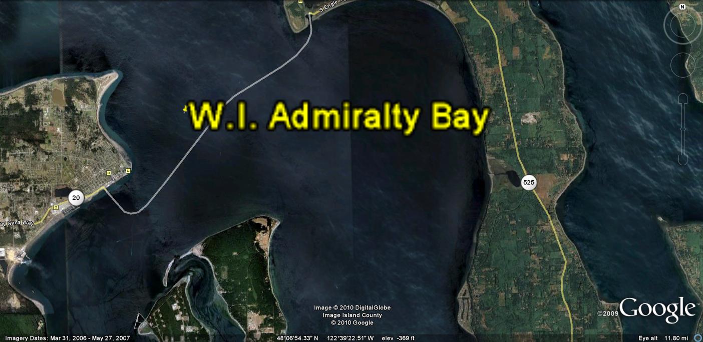
Whidbey and Fidalgo Islands, where lateral shear has been isolated at the beach of Admiralty Bay (Ledgewood concrete slab shear, house slumping onto the beach off Seaward Way, and a vertical slab of Mesozoic rock is seen at the Rosario Park at Fidalgo.
First is the definite left-lateral fault cutting the beach at Ledgewood and extending NW-SE towards the swale at Pacific University and between Baby Island and Whidbey at Saratoga Road on the peninsula at this eastern part of the island. This is shown below for Admiralty Bay, where the fault is left lateral now, compared to expected right-lateral for sinking during the ICE AGE, OR PLEISTOCENE. Anyone having studied sinks, such as sinkholes, depressions, basins, and asteroid craters- will have noticed that they are round, such as is Admiralty Bay. The Gulf of Mexico adjacent to the asteroid strike known as Chicxulub (off Yucatan, Mexico) is another example, and we have this presented in a previous Blog. Notice that Admiralty Bay is circular, and this implies that it is rotating CW, as for a sink. However measurements at the village to the east of Hancock Lake (Keystone Lane), show that the beach is rising. This is due to REBOUND, from loss of the weight of ice, and indicates that Coriolis rotation is immediate- yielding information about reverse faulting, lateral movement, and shear of the sediments now in the Bay and Lake. The bay was formed as a round sink- when it was sinking- and it has retained the geometric shape, subsequent to rising with rebound.
The Bay has had a reversal of the lateral faulting direction since the end of the Ice Age, showing that the change occurred in just over 10,000 years. It is now possible to calculate the rate of shear, with precise measurements on slickensides, concrete slabs, and diversion of river paths (as at the south side of Mt. St. Helens, in a previous Blog):

This is shown expanded, with north to the right, in the following Google photo:

EXPANDING FURTHER, YOU CAN SEE THE CHANGE OF SILTATION IN THE BAY BOTTOM- INDICATING THAT THE FAULTING CREATING THE DISRUPTION HAS CHANGED DIRECTION (AND NOT JUST FROM SWITCHING FROM ONE SIDE OF THE FAULT TO THE OTHER:

This information, although faint, indicates that the mechanism of rebound after sinking can supply the movements and consequent rotation direction on the part of the Olympic Peninsula (which was covered with significant thickness of ice during the Pleistocene).

A MAP OF THE ENTIRE ISLAND IS SHOWN BELOW, SO THAT YOU CAN SEE THE COMPLEXITY OF THE VARIOUS BEACHES, HEADS, POINTS, AND REBOUND-SINKS:
 BELOW IS MY MODEL FOR BAYS AND COASTLINES, WHICH ARE INFLUENCED BY CORIOLIS ROTATIONS, FOR OAK HARBOR AND CRESCENT BAY:
.jpg)
BELOW ARE PHOTOS WHICH YOU CAN ANALYZE YOURSELF, FOR THE TOWN OF OAK HARBOR AND SURROUNDING BAYS- CALLED HARBORS BY THE USNAVY:

.jpg)
FORMATION OF FEATURES FOUND AT ISLAND COASTLINES, WHERE THE CRUST HAS TRACES OF DYNAMIC MOVEMENTS REMAINING IN THE MARINE BOTTOM. BELOW IS THE DIAGRAM RESULTING SO FAR, WHICH WILL BE UP-DATED AS CASES ARE INCORPORATED:

HIKING ON WHIDBEY ISLAND, DURING SUMMER 2010
WE WILL START THE HIKING SEASON BY RE-INVESTIGATING THE LARGE NW-SE FAULT CUTTING ACROSS THE "SKINNIEST PORTION OF WI" WHICH HAS FORMED BABY ISLAND, CAUSED A HOUSE TO FALL INTO THE BEACH AT LEDGEWOOD, AND CREATED THE SWALE AT THE SEATTLE UNIVERSITY LOCATION NORTH OF THE PROTRUDING PORTON OF ADMIRALTY POINT. AFTER REVIEWING FEATURES WHICH MAY BE CONNECTED WITH THE EXTENSION CAUSED BY THE OLYMPIC MOUNTAINS, WE WILL VISIT THE PENINSULA- INCLUDING SOL DUC HOT SPRING, CRESCENT LAKE, AND INITIATE SEARCHES FOR SLICKENSIDES- WHICH WLL ASSIST IN REACHING CONCLUSIONS AS TO WHETHER THE MOUNTAINS ARE PUSHING WESTWARD (RELATIVE TO LOWLANDS).

THE HIKES WILL BE MADE ON THE FOLLOWING BEACHES, NEAR GREENBANK (NORTH IS TO THE RIGHT, FOR BOTH PHOTOS BELOW):
 WHIDBEY ISLAND IS EXPANDED BELOW, TO ALLOW CLOSER INSPECTION OF THE VARIOUS GEOGRAPHICAL CONFIGURATIONS (WHICH OFTEN ARE RELATED TO THE UNDERLYING EARTH MOVEMENTS):
WE START WITH VIEWING THE ALMOST CERTAIN LEFT LATERAL FAULT WHICH CROSSES ADMIRALTY BAY, NW-SE, TO SEPARATE BABY ISLAND FROM THE MAIN ISLAND. NOTICE THE INDICATIONS IN THE SARATOGA PASSSAGE TO THE EAST OF SHEAR LINES (IN THE BAY BOTTOM) WITH THIS ORIENTATION.

Above is shown an analyzed photo from Google Earth, showing the indicated trends.

OTHER INDICATIONS OF NW-SE SHEAR ARE SHOWN BELOW, IN THE MASSIVE DUNE SANDS PROTRUDING AT DOUBLE BLUFF- WHICH IS A PROMONTORY STATIONED NEXT TO A SINK AT THE VILLAGE OF MUTINY BAY (IT ROTATES CW, TERMINATING AT THE DB PARK AT THE END OF DOUBLE BLUFF ROAD).

 THE EARTHQUAKES HAVE CREATED CAULIFLOWER STRUCTURES, WHICH OCCUR ALONG VERTICAL SHEAR PLANES RESULTING FROM ROTATIONS ALONG THE BEACH DUNES OF ESTIMATED 40-50 KYEARS AGE:

Ledgewood Beach cliffs and NW-SE fault
Hiking on the west beach of Whidbey Island during May 27/10 produced the following photos of anomalies:
Below photo shows the kilometer fault zone, which starts at a location above the beach, near Seaward Drive, where a home slid into the zone, via slumping, over a period of time.

The homeowner had time to add drain pipes, piling, and other hardware to reduce the movement. All was to no avail, since the house slid, splintered, and had to be removed during 2008. The slump started before 1997, when I arrived, but I have previous photos (in a earlier blog in this series) showing the ruins. The movement has been monitored by myself, using parallel garage and house concrete slabs, for a 40 year age edifice, Nails protruding from a 2x4 buffer between the two slabs have been moved southeastward on the south slab. This shows that this is due to a left lateral fault, where the velocity has been approximately 2 cm/40 years= ½ mm/year. This is not indicative of the total movement, since the shear is spread over a km zone. Altogether, the shear of one stationary block vs. the adjoining one is on the order of 1 km/30 meters x the local movement= 30x ½ mm/year= 15 mm/year. However, this is merely an estimate, since a lot of the zone may not be shearing, but merely moving along with the km block. Below is shown a photo of cliffs south of the main shear zone, where shear has produced weaknesses in the sedimentary column, allowing earthquakes to produce liquefaction upward into the weakened rock (PreStone, I dub this slightly cemented and compressed sand and silt):

NOTICE THAT THERE IS A PROGRESSION IN GRAIN SIZE, DUE TO GLACIER MOVEMENT: WHEN RETREATING, THE ROCK DIAMETER BECOMES SMALLER AS THE ICE MOVES FURTHER AWAY (STREAM CURRENT IS LESS WITH DISTANCE FROM THE GLACIER).THERE HAVE BEEN AT LEAST 3 GLACIAL STAGES OF RETREAT AND ADVANCE SH0WN ON WHIDBEY ISLAND).


BELOW IS A GOOGLE PHOTO OF THE LOCATION OF ROCKY POINT- THE NEXT HIKE TO BE UNDERTAKEN, FOR UNDERSTANDING THE ROTATIONS AND THRUSTING OF METASEDIMENTS OCCURRING ON WHIDBEY ISLAND. WE HAVE ALREADY NOTICED THAT PENN COVE HAS FOLLOWED A WEAKNESS CREATED BY THE SHEAR ON-GOING ON WHIDBEY ISLAND. FROM THIS PHOTO IT IS SEEN THAT THE ONGOING SHEAR HAS ALIGNED PENN COVE WITH THE GLACIAL GROOVES NOTICED ON GOOSE ROCK (NORTH, NEAR DECEPTION PASS). FURTHER, AS NOTICED OVER THE TEN YEAR INTERVAL OF MY HIKES THERE, ROCKY POINT OUTCROP IS NOT ONLY SINKING BUT BEING SHEARED FURTHER- CREATING SPRINGS AND N-S FRACTURES:
 BELOW ARE PHOTOS OF ROCKY POINT METASEDIMENTS AND A GOOGLE EARTH VIEW OF THE COAST (ROTATED 90 DEGREES, TO GET MORE OF THE BEACH INCORPORATED):
 ROCKY POINT HAS EITHER SLICKENSIDES OR GLACIAL SCRAPE MARKS, AND IT IS DIFFICULT TO DIFFERENTIATE THEM. FOR THE HARD-FACED SILICATES WHICH SHINE AND APPEAR TO BE BUFFED WITH JEWELER'S ROUGE, THESE SEEM TO BE SLICKS, BUT OTHERS WHICH YIELD SCRATCH MARKS TO A METAL OBJECT ARE NOT SO OBVIOUS. IT DOES SEEM THAT THOSE ALIGNED WITH OTHER GLACIAL TRACES (N70E TRENDS, OR N-S ON MOST OF THE ISLAND) ARE LIKELY GLACIAL GROOVES:

I WILL DIGRESS TO LOOK AT THE LARGER VIEW OF THE ENTIRE AREA. I PREDICT THAT THERE WILL BE A CCW-ROTATING CORIOLIS CELL SOUTH OF THE LEFT-LATERAL DARRINGTON OR DEVILS MOUNTAIN FAULT, SINCE THE RULES HAVE BEEN CONSISTENT (WHEN EVALUATING THE PHYSICAL MOVEMENTS CREATED BY LARGE FAULTS):
1. RISING AREAS HAVE CCW ROTATION;
2. A MOVING THRUST CREATES A ROTATION ABOUT THE PRESENTED LINEAR (WHICH IS A STRAIGHT LINE, OR CENTERLINE, FOR A PORTION OF THE PORTRAIT);
3. A LEFT-LATERAL FAULT HAS THE NORTH SEGMENT MOVING TO THE LEFT OR WEST. THIS, IN CONJUNCTION WITH THE RELATIVELY-EAST-MOVING MOVEMENT ON THE SOUTH SIDE, CREATES THE CCW ROTATION; AND,
4. THE LONGER THE STRAIGHT LINE PORTION, THE LARGER IS THE DIAMETER OF THE REACTING CELL, RC.

AS PREDICTED, ALL OF THE RULES ARE OBEYED, BUT THERE MUST BE SOME BUFFER CELLS (ROTATIONS BETWEEN TWO LARGER CELLS) TO PREVENT GEOTHERMAL EFFECTS- SUCH AS HOT SPRINGS OR VULCANISM- FROM TWO CELLS MOVING IN SIMILAR DIRECTIONS (CW VS. CW). AN EXAMPLE OF THIS REVERSAL OF SINKING AND RISING IS PRELIMINARILY SHOWN IN THE FOLLOWING DIAGRAM:


POLNELL TOMBOLO EAST OF CRESCENT BAY SINK (NOW RISING WITH REBOUND)
BELOW ARE PARKED PHOTOS OF THE POLNELL TOMBOLO, WHICH STRADDLES THE LEFT LATERAL FAULT MAPPED BY THE USGS, AS A SPLAY OF THE UPSALADA FAULT TRACING PARALLEL TO SILVER CREEK. THIS TRACES ABOUT N110E ALONG AN ARCUATE CONVEX-EASTWARD SET OF CLIFFS (INDICATING A RISING AREA) NEXT TO THE SINK OF CRESCENT BAY- ROTATNG CCW, AND THIS WOULD FIT WITH THE NORTH SIDE MOVING WESTWARD, AND THE SOUTH SIDE MOVING EASTWARD. THIS IS CREATING A CCW ROTATION ABOUT THE CENTERLINE FAULT WHICH IS SHOWN IN THE CLIFFS AS A CAVE WITH IRON-FACED SLICKENSIDES ON A CALCAREOUS VERTICAL PLANE:


A TOMBOLO WHICH HAS ATROPHIED TO AN UPLIFTED ISLAND, WITH A LARGER CONNECTION TO THE MAIN ISLAND (OAK HARBOR AND CRESCENT SEPARATION BY A ROTATING PENINSULLA AND FAULT SYSTEM).
 A CAVE HAS FORMED AT A WEAK PLANE IN THE UPLIFT. THIS COULD BE CALLED AN INFLECTION, WHEN VIEWING GOOGLE EARTH (IN PLAN VIEW):


THE HOUSING AREA SOUTH OF THE NAVAL COMMISSARY (ABOVE AND BELOW) IS AN UPLIFT WHICH WAS FORMERLY A TOMBOLO, FORMED BY DOUBLE-FAULTING AT THE SWALE AND SOUTH OF THE COMMISSARY. FAULTS ARE SHOWN IN THE FOLLOWING DIGITAL PHOTOS AND GOOGLE EARTH VIEWS:
 THIS IS VIEWED IN DETAIL, AND BY REFERENCE TO A SMALL BAY TO THE SOUTH OF THE FAULT SYSTEM:
THE FAULT SYSTEM AND ITS ASSOCIATED DIPS OF SEDIMENTARTY BEDDING, THE TILT OF THE FAULT PLANE, AND THE NEXT BAY AND ROTATION TO THE SOUTH MAY BE REFERENCED BELOW:
 BELOW IS THE CLLOSEST VIEW SOUTH OF THE FAULTING AND DOG POUND:
ANOTHER CASE WHICH I HAVE OBSERVED IN PREVIOUS YEARS IS THE JUNCTION OF PENN COVE AND SARATOGA PASSAGE, WHERE THRUSTING IS APPARENT- ALMOST BESIDE THE COUPEVILLE WHARF (TO THE WEST ABOUT 100 YARDS). YOU CAN TAKE SOME STAIRS BESIDE THE LONG PIER THERE, AND WALK TO THE WEST ALONG THE BEACH. THE AREA IS SHOWN ON THE FOLLOWING GOOGLE PHOTO:

Penn Cove- Saratoga Passage junction, at Coupeville town A more complicated portrait of beaches, sheer cliffs, faulting, glacial traces, and Coriolis rotations shown at the waterline is that of Penn Cove- a glacial gouge trending N70E-250 degrees from the ship passage. Shown ABOVE is a map of the region, where anomalous iron springs, circular features at the cliffs, glacial kettles, excellent soil in the surrounding Ebby’s landing Preserve, and springs along Madrona Way are located.
The easiest anomaly to see is that just west of the wharf at Main Street (there is a museum and walkway over the waterfront also), along the beach- where an unconformity and faulted section can be seen in the sheer cliff’s about 100 meters west of the wharf walkway.

Below are shown how slickensides are initiated along sheared and uplifted areas on Whidbey Island, with a view of understanding how this mechanism proceeds:

 PHOTO ABOVE SHOWS A THRUST, WHICH HAS BEEN REVERSED DURING THE MELTING OF THE ICE (CW FOR SINKING, CCW FOR RISING WITH REBOUND). THIS IS SHOWN IN LARGE VIEW BELOW, TO SHOW THE SENSITIVITY OF THESE SOFT, LOW VISCOSITY SEDIMENTS- PRESTONE- TO ROTATION, SHEAR, AND LATERAL MOVEMENT OF THE CRUST:
 OTHER VIEWS ARE SHOWN BELOW, WHICH SHOW THE NORMAL BEDDING (ALMOST LEVEL) NEARBY TO THE EAST, OF TILL AND GRAVEL FROM THE MELTING OF THE ICE:

BELOW IS THE THRUST, LATERALLY, OF INTERGLACIAL SILT, TILL, AND SEDIMENTS WHICH FORM THE INITIAL PRE-STONE CONTAINING THE EARLY SLICKENSIDES COMPRESSION. NOTICE THAT THERE IS A DARK CHERT-LIKE (NOT AS HARD) INTERIOR AND A SOFT SILT COVERING. THESE SLICKS ARE USUALLY SHAPED LIKE AN OVAL LATH, TAPERING TO AN EDGE ON ALL SIDES, AND SOFT (BREAKABLE WITH THE HAND) QUATERNARY NODULES. THE PHOTO BELOW SHOWS THAT THEY FORM AT THE HIGH-STRESS LOCATIONS OF LATERALLY-MOVING SHEAR PLANES:


ANOTHER CASE I AM INTERESTED IN ANALYZING IS THE HONEYMOON LAKE. THIS IS THE AREA AROUND A HOUSING DEVELOPMENT, WHERE THERE IS FAULTING ON A MINOR SCALE. YOU CAN SEE THE TRACES OF ROTATION FROM THE HONEYMOON LAKE SOUTH. THERE ARE SHEER CLIFFS NEAR THE CLUB ON THE BAY, AND THE PATTERN OF LAKES, STREAMS AND DIM TRACES WILL BE SCANNED IN A FOLLOWING PHOTO (WATERWAYS ARE PARTICULAR SENSITIVE TO FRACTURES OR FAULTING IN THE CRUST- WHERE EROSION MAKES IT EASIER TO FORM A PATHWAY):
 BELOW ARE PHOTOS MADE JULY 2010. OF THE SHEAR AND UPLIFT OF CLIFFS (WITH RESULTING SLUMPING AND FRACTURING) JUST SOUTH OF THE HONEYMOON LAKE CLUBHOUSE- ON THE SHORE OF HONEYMOON BAY, CIRCULAR PORTION:

