SUMMARY:
The
Earth’s CRUST splits along linear arrangements of Hills and Mountains, and then
it EXTENDS perpendicular to the splits – creating Valleys. This occurs on
small scales- such as Mima Mounds- to LARGE SCALES (such as the Wasatch-Sierras
Mountains pair). Valleys are created as the earth splits, and the developments
are the same as the Creeks and Rivers- which parallel the split. These SPLITS
or “RIPS” exhibit Mounds of 32 UNIT lengths, due to the NUMBER 800= 32 x 25 being
a CONSTRICTION- which is an INTEGRAL COMBINATION of the whole numbers: 2, 4, 5, 8, and 10. (in UNITS of mm, meter, km or their harmonics).

There are other INTEGRAL COMBINATIONS of the NUMBERS: 2, 4, 5. 8. 10, but NOT 3 or 7; the 2 sided geometric ARCUATE
FIGURE is not linear- it is the beginning of the OPENING or “RIP” of the LINEAR
CHAIN, which has 2 arcuate sides OPENING the chain into 2 separate features. As
TIME PASSES, the arc becomes more and more a SET of linears- forming a POLYGON
(first a RECTANGLE- the normal BEDDED SCARP; secondly a PENTAGON, with 5 sides of
72 degree spacing; thirdly an OCTAGON, with 8 sides: and then the cycle
repeats, with 10 sides- the first HARMONIC. This is the MOVEMENT found for the WASATCH LINE SEPARATION of the Wasatch Highlands from the Sierras something less than 100 m.y. AGO! I will investigate the HEXAGON
later, since I have found it occurs in OUTCROPS (RARELY), and it involves the
FORBIDDEN 3 multiples NUMBERS. GEOMETRIC FIGURES with 50 sides may be expected, since
this ‘FITS’ within the 800 multiple (50 segments, with 7.2 degrees spacing). Although
36 sides (1/10th of a circle) are expected, this does not yield an
INTEGRAL RATIO: 800/360= 2..22222- an IRRATIONAL NUMBER, and this RESULTS in EARTH’S
CRUSTAL CONFLICT!
The EARTH’S CRUST splits along a RISE-
gradually forming an ELLIPSE as the LINEAMENT (linear or DIVIDER) expands,
forming a 2D feature from the ORIGINAL TRANSFORM (line of split). This is exhibited in 2 scales: first a POLYGON outcrop- which may have more sides (linears or lineaments) than 10, since there is some SUBJECTIVITY INVOLVED IN DECIDING WHICH ARE "PURE" LINEARS! Case above infers that the Wasatch and Sierras were once a SINGLE RANGE, which split in two parts as the western part moved with the normal TIDAL RATE of 17.48 km/m.y. and the EXTENSION created younger RANGES (in the Basin and Range)- each million years. This 13 m.y. period has created "RIPPING" at the NV, OR, UT borders, with accompanying RHYOLITIC EXTRUSIONS (NOT DEEP ENOUGH in vertical rotation to reach the MANTLE)- 13 different blasts 1 m.y. apart. Later the Valleys extended, becoming 40 km wide instead of the normal 20 km/m.y.:


After seeing this BEAUTIFUL COUNTRY on Google Earth, I just had to see it "CLOSEUP":


Compare the bedded OUTCROP, below, to the 50 m.y. Basin and Range POLYGON:

It looks more likely that there are 5 linear SEGMENTS on the left and right sides, with 3 on the bottom and top; this makes 16 altogether. This is shown below, un-inscribed, so that you can make your own judgement:

A better OUTCROP of POLYGONS is shown for the YELLOW KNOLLS region, north of St. George, UT- where the 4, 5, and 6 sided figures occur on a tilted MOUND (rising knoll, which develops rectangles at the base and inreasing number of sides as the TILT becomes less):

These are formed by LATERAL GRAVITATIONAL ADJUSTMENTS, as the upper part of the MOUND "TWISTS" relative to that at LOWER ELEVATIONS and STEEPER SLOPES!
BELOW is the YELLOW KNOLLS region, where CONTINUED COMPRESSION has rotated and sheared the YOUNGER-SIMPLER MOUNDS:

A MORE ACCURATE COUNT of MULT-SIDED POLYGONS is shown below:

Notice that there are EXHIBITED HEXAGONS or 6-sided geometrical RE-ARRANGEMENTS! This forces me to ACCOMMODATE them; they do NOT FIT in the INTEGRAL EQUATION, which excludes multiples of 3 or 7 (800= 50 x 16, or 100 x 8, or 25 x 32, or any other multiple using 2, 4, 5, 8, or 10)! These INVOLVE TRIANGLES, which I have rarely found on the EARTH'S CRUST, but exceptions (RARELY) OCCUR- such as Great Bear Lake, the EVAPORITIC BASINS of the NW, or Death Valley:


Obviously, ALL of these exceptions are MAJOR ANOMALIES, and must be incorporated!

The HINT is the association of TRIANGULAR FEATURES with CRITICAL LATITUDES, LONGITUDES, and TIME (shown in the SERIES: 1, 4, 16, 64, 256, 1,024, and 4,096 m.y.). When these 3 entities coincide, there occurs a GREAT INSTABILITY on the EARTH'S CRUST! The events are: Ice AGE, NW Passage BREAKUP, Columbia FLOOD basalts, KT boundary, PTr great EXTINCTION, Grand Canyon GREAT UNCONFORMITY, and the Moon GRAVITATIONAL DEVELOPMENT of Continents' RISE-EXPANSION.
GOLF COURSES trim and make the MIMA Mounds more noticeable, but they occur wherever there is local CRUSTAL COMPRESSION- such as with the GREEN SPRINGS ANALEMMA:

They usually are arrranged as an ELLIPSE, with 12-13 mounds/development (number of FULL MOONS in a year: alternating with 13 following 12 in a year):

Given sufficient time (40 k.y. in this case), the MOUNDS DEVELOP a "TIT"- which will widen into a noticeable ANALEMMA:

MIMA MOUNDS are not so noticeable when the GRASS is not encouraged:


This is part of a LARGER DEVELOPMENT, but similar RULES APPLY:
1. POLYGONS form with LINEAR SIDES;
2. Sufficient sides make the POLYGON CIRCLE-LIKE, with the DIAMETER/TIDAL RATE= INTERVAL TIME (AGE for the ongoing cases);
3. SEGMENTS have lengths of 32 meter MULTIPLES (64, 128, 256, 512, 1024, or 2048 meters, km, up to 40,000 km- the EARTH CIRCUMFERENCE; and,
4. The ANGULAR SHIFT has its own spacing- being 15 degrees (24 sided figures), 30 (12 sides), 36 (decagons), 45 (octagons), 60 (HEXAGONS), or 90- the normal OUTCROP RECTANGLE.


An INTERMEDIATE size POLYGON for my hiking area, is shown below- where every "LAST DAB" may be hiked and appreciated close up!:


This case
has an AGE of 50 m.y.- the TIME NEEDED to form the Basin and Range PROVINCE,
adjacent to the Colorado Plateau (which started at the Taos, NM- Llano Quemado
EXTRUSION Valley at 41 m.y.).
That this is
a UNIVERSAL FEATURE is shown for the Malheur Basin in Southern Oregon (near
Burns, OR)- where the Playa bottom exhibits the E-W DEVELOPMENT of a LINEAR
into an ELLIPSE with time:


I will bring this up again, without the interpretations, so that you can see the FAINT SHEAR LINES in the lake bottom:

I took the ORIGINAL when there was shallow water, but now the increasing water levels have OBSCURED the LINEARS! There are N-S INDICATIONS, but only a faint-fuzzy E-W SPLIT!

There is something SIGNIFICANT occurring at the Humboldt River Valley, at approximately 41N 117W, and because this is a REGIONAL DEVELOPMENT, the REFERENCE is NOT THE SAME as that for the Globe. I'll try to estsblish the LINEAR REFERENCE, which is probably NOT at a N-S ARRANGEMENT! We start with a more careful analysis of the last AXIAL (Milankovitch's 41 k.y. POLAR WOBBLE CYCLE):

The PROGRESSION of the river valley is in a CYCLE- moving from the south and returning now. I calculate the cycle at near 48 k.y. and my errors are such as to expect that it should be 41 k.y! A view of it as an ELLIPSE would indicate that it is in the 100 k.y. cycle (Molankovitch's ELLIPTICAL movement away from the normal near-circular path):

BOTH CYCLES are EXHIBITED!
VOLUMINOUS meanders and partial FIGURES 8 attest that this is an area which is moving LATERALLY much DIFFERENT than normal!
VIRGIN ANTICLINE is PROPORTIONAL to the CASE HISTORY of the SPREADING-ENLARGING Basin and Range- where the basin ENLARGES from a 800 km SPLITTING LINEAR to a 2 Dimensional 16-sided POLYGON with 250 km length SEGMENTS, as TIME passes!
The Virgin ANTICLINE has 8 sides, 45 degree-spaced, with SEGMENTS LENGTHS of nearly 20 km each. This fits the MEASUREMENTS of 160 = 8 x 20, compared to the Basin and Range of 800 = 16 sides by 25 km each, ORIGINAL LINEAR! I will re-measure:

The GEOMETRICAL POLYGON CONFIGURATION is approximately correct, but there are my USUAL ERRORS of less than 5%!
The PROPORTIONALITY FACTOR is 5 to one, and this shows that GRAVITATIONAL ROTATION-SHEAR-RISING (or SINKING) PROCEEDS CONTINUOUSLY for the ENTIRE EARTH CRUST, on MANY SCALES!
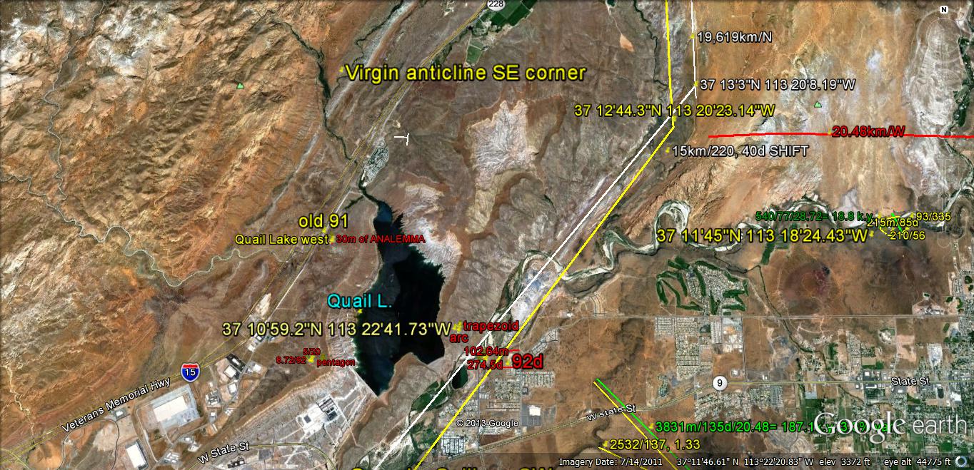
I will document this FINDING FURTHER but it appears that the GEOMETRICAL POLYGONS are a result of the 2 dimensional GRAVITATIONAL STRESS on a 3 dimensional CURVILINEAR EARTH- where the CRUST adjusts to the continual changes by REARRANGING CRUST in MULTI-SIDED POLYGONS. Below is QUAIL-VIRGIN ANTICLINE:


Viewing the Qsna QUADRANT:

1. There is an INDENT in the Gulf
SEGMENT, showing that the Gulf of Mexico is expanding to the north. This is
expected, since the Gulf ellipse ENLARGES WITH TIME;
2. The traces were diverted at 800 km,
with the angular turns made at ANOMALIES, and where GRID LINES or ARC CENTERS
were in agreement, or any
other INTEGRAL COMBINATION of the NUMBERS: 2, 4, 5. 8. 10, but NOT 3 or 7; the 2 sided geometric ARCUATE
FIGURE is not linear- it is the beginning of the OPENING or “RIP” of the LINEAR
CHAIN, which has 2 arcuate sides OPENING the chain into 2 separate features. As
TIME PASSES, the arc becomes more and more a SET of linears- forming a POLYGON
(first a RECTANGLE- the normal BEDDED SCARP; secondly a PENTAGON, with 5 sides of
72 degree spacing; thirdly an OCTAGON, with 8 sides: and then the cycle
repeats, with 10 sides- the first HARMONIC. I will investigate the HEXAGON
later, since I have found it occurs in OUTCROPS (RARELY), and it involves the
FORBIDDEN 3 NUMBERS. GEOMETRIC FIGURES with 50 sides may be expected, since
this ‘FITS’ within the 800 multiple (50 segments, with 7.2 degrees spacing). Although
36 sides (1/10th of a circle) are expected, this does not yield an
INTEGRAL RATIO: 800/360= 2..22222- an IRRATIONAL NUMBER, and this RESULTS in EARTH’S
CRUSTAL CONFLICT!
3. Traces were made until 8 SEGMENTS
were found- which represents a quarter of a circle (90 degrees). This entails
800 x 32 km, or 25,600 km TOTAL Qsna CIRCUMFERENCE (64% of the earth circumference).
This terminates near Cape Hatteras, which is the east protrusion of the
ORIGINAL CIRCULAR ORB (expanding in all directions from the ORIGINAL UPLFT from
Moon’s GRAVITY- 4096 m.y. at 1 mm/yr. to yield 4096 km DIAMETER);
4. TRACES regularly angle to the east,
excepting Baja segment, where the change is slight, but indicates an INFLECTION
in the trace. This suggests that Baja is also INDENTING to the east (opposite
to normal west EARTH TIDES); and,
5. Florida and Mexico are TRAVERSED-
meaning that they have formed SUBSEQUENTLY to the OLDER Qsna development. The
SIZE of the PROTRUSIONS is proportional to the TIME of development.

Above is my own CREATION, the HEMISPHERE from Mendicino, CA to the West coast of Africa- where the MAR departs to the west. This has 10 degree shifts for 1600 km SEGMENTS- making a total of 16,000 km for the TOTAL. This is 32Kkm for 2 halves, so that the MULTIPLIER to attain the 40,000 km CIRCUMERENCE is 1.25- the constant in the series N2 = N1 x 1.25= 1.28, 1.6, 2.0, 2.5, for the PLANETARY GRAVITATIONAL PERTURBATIONS!
I will INTRODUCE the next FINDING, for a SUBSEQUENT REPORT, with an ANALYSIS of EVAPORITIC BASINS (PLAYAS) in the OR, NV, and UT deserts:


Easily seen is the CONTRIBUTION that the EVAPORITIC BASINS make; the USUAL 12-13 LAKES-BASINS form in the last 10 m.y. and a smaller lake near HIWAY 31 is only 1 million years old:


STAY TUNED!