Below is the GLOBAL MODEL, the 3 SEGMENT MODEL for the entire earth:

I should explain that there is no compromise between these two positions; there is no chance to Salvage the Mantle view. It is wrong in such a way that it CANNOT be made right. Conversely, the UP analysis pertains ONLY to the Crust, and progressively less so with depth of the investigated activity!
The BASIS of the Gravitational Force position depends upon the Lateral and Vertical movement created by the Solar System Masses- planets, planetoids, asteroids, and comets- which ORBIT away from the Ecliptic Plane, and ATTRACT portions of the earth’s Crust part of each Earth year. This is done via the ATTRACTION of these ORBITING masses as they move away from the Ecliptic, separately from the equilibrium of these bodies with Sun’s gravity along the Plane. This creates UPLIFT for ABOUT a fourth of their ORBIT (opposition) lateral shift for half of their year, and SINKING whenever these masses are in conjunction with the Sun. All masses have an Imclination ANGLE which is made with the plane, relative to the Earth, which is used as the BASIS of all our observations. The angle is smallest for Uranus (.77 degrees), and the LARGEST, so far, is Pallas (34 degrees); there may be those with INCLINATIONS near 40 degrees- which is the LIMIT, since they would then be external to the ASTEROID BELT.
We will examine these two viewpoints, using MODELS:
The model developed by Matsushima is shown below, to use as the best comparison with mine, developed from EXHIBITS shown on Google Earth:
Above MODEL exhibits 4 ROTATIONS, which can be LABELLED: NW, the Northern Pacific SINK; NE, the Britain- North Atlantic RISE; SE, the South Atlantic SINK; and SW, the South Pacific RISE. I agree with the four part DIVISION of the Crust. There is a HINT that this is NOT in agreement with CRUSTAL MOVEMENTS, since the SW sink lies below the EQUATOR (hence would rotate CW with RISING there:

The Matsushima MODEL may account for the Mantle VARIATIONS-ROTATIONS, since it shows the 4 principal Ocean Basins. However, it does NOT show Major ANOMALIES in the Crust, such as the Hawaiian Island TREND, the Iceland EXTRUSIONS, or the Marianas TRENCH- which is 10 km deep, almost reaching the Mantle! It does show the Alps RISE, and that may be PARTLY related to the Mantle. I believe from Google Earth information, that the Alps are reacting to the E-W slice at 45N latitude (Lake FORMATION Latitude), and represent a VERTICAL ROTATION or thrust. This remains to be proven, since no such rise occurs north of the American continental Great Lakes or the 45N Atlantic (salt water)!

Look at a DIMINUTIVE MODEL, where the 800 km CP, and the Basin and Range extend to the Death Valley TRENCH- a total of 1600 km, or .04x the Earth’s CIRCUMFERENCE (800 km is the Standard REFERENCE, or a fiftieth of the N-S CIRCUMFERENCE). This model shows that the Cp and BR are divided by a N-S linear (divider) at the 800 km location, and that this “FITS” an equation of the TYPE: (90- 2)/2= 44, RELATING to the Moon/Sun ratio, which is checked by: (90- 45)/45= 1, where the Binary Theorem predicts that the unit must be added to 1, to HARMONIZE with other GRAVITATIONAL RESULTS, such as Inclination ANGLES from the Ecliptic Plane: Uranus, .77d and Neptune, 1.77, with a difference of 1 unit (approximately), and 1 Unit difference for Moon's 13.18 degrees/Earth's ROTATION, compared to Sun's 14.18 per Earth ORBIT:


An EXAMPLE of the 3 feature MODEL- that is easily HIKED and RECOGNIZED- occurs at the AZ-UT border, 10 miles south of Huricane, UT. The road is unimproved GRAVEL, and is shown below:

3 SEGMENT MODEL above, is a General GLIMPSE of those found on Google Earth, and in Field Photos, and is easily MEMORIZED for comparison with Field FEATURES, e.g. the Colorado Plateau and its western companion- the Basin and Range PROVINCE:

There is a DIVIDER at the Hurricane Fault, Hf, at 800 km from the YOUNGEST Mts. to the east of the ROCKIES, and this is SIMILAR to that shown at the DEATH VALLEY, DV Meridian (which aligns with the Great Bear Lake- a MAJOR ANOMALY in the Crust)!

Death Valley SINK, above, is on the SAME MERIDIAN as Great Bear, below:

Great Bear Lake, ENLARGED, shows ARCS formed by ROTATIONS just below the ARCTIC CIRCLE at 66.567N Latitude (above which NO Sun or ZERO Inclination masses can create linears):

In short, 800 km divisions are NATURAL DIVISIONS of the Earth (a fiftieth of the Circumference, and are EQUIVALENT to 7.2 degrees of N-S ARC). 400 KM IS EQUIVALENT to 3.6 degrees, which is the SHIFT of the POLES each 40.96 million years (with an UNKNOWN Time Interval for COMPLETION). This is shown by the 400 km shift from Lomonotov inactive to Gakkel Ridges (Geothermally Active now):

Polar views:

Arctic and Lomonotov Ridge

ICELAND:

BOTH Iceland, above, and Hawaii, below, are MAJOR ANOMALIES, which are NOT SHOWN on the MANTLE model:

LARGER VIEW:

Global Earth Tides Directional ARROWS, on the GLOBAL portrait, should be remembered as a PATTERN, 2 MAJOR ROTATIONS and an INSERTION of Australia (TIT) northeastward:
.jpg)
The 3 segment MODEL has a slight ERROR; the Eurasia ROTATION has a diameter which encircles at least part of the Australian northerly-moving RISE. These features are REPLICATED in smaller ones, which may be viewed CLOSE-UP! This one I have photoed at Warm Springs State Park, NV, which is near I-15 and Moapa Valley; the rise creates the 70F temperature, and can be seen to lie outside of the sink, while creating a smaller RISE within the east border of the LARGER RISE:

Warm springs divider
Another I have documented on Whidbey Island occurs south of a "Hole", artificially made by man, with a DIKE. Notice the RISE, south of which exists MANY SPRINGS, due to a SCARP (Slice) to the south:


Another SLUMP to the north occurred in 2013:

An Alpine Meadow
(Sierras, from Berkeley, 1967)
A splash of yellow on a field of green
Caused the bees to stir-
Raising hopes of winter honey,
Where snapdragons previously were…
Sunlit slopes and fragrant air
Keep the bees a-hum
Raising petal fetishes,
Where the bees are from.
What is your secret of activity
All the summer long?
I hope to break the meadow code
Of your flower song.
Harold L. Overton
Hancock Lake vertical Thrust PLATES disappeared within 4 years of OBSERVATIONS:

Thrust Plates, below, are THIN in the E-W dimension, and are easily ERODED by winter storms:

This COMPARISON emphasizes that the Larger CIRCLE of Eurasia has a diameter which encompasses part of Australia- at least to the center of the Continent (and possibly Antarctica). The Ratio of these American continents to the Eurasian yield a CLUE to the incipience of these rotations; it is one-half approximately, indicating that the Moon and Sun (Ratio= 2) have created the N-S vs. the E-W DIVISION of the Earth, which is being PENETRATED by the almost Northerly-moving Continent (including New Guinea to the Tonga Trench). My 3 segment MODEL must be modified to include Australia in the “TIT” moving N20E along the Tonga Trench, as with the GLOBAL PORTRAIT!

Google Earth allow MEASUREMENTS to be made more ACCURATELY than hand-held COMPASSES:


ENLARGING:

This agrees with my model shown below, where the Crust has 3 Major segments.
The 3 segment MODEL has been MODIFIED to incorporate the INTRUSION of a rise from an EXTERIOR SOURCE (either from the south or the north), which always creates an incomplete analemma or Figure 8. It is shown below:

As mentioned above, the Australian Block of Crust has been partly INSERTED into the Eurasian CIRCLE; we must also consider the MAJOR ANOMALIES to the NW!
The Caspian Sea is another PRIMARY REFERENCE, related to Venus and the 1.6 to 1.625 RATIOS; it lies on CRITICAL COORDINATES, 45N being one which EXHIBITS most of the LARGE LAKES, including the Mediterranen SALT WATER SEA;

The segments shown were found by TRIAL and ERROR, using Google Earth (and FEEDBACK), from information developed with the Binary Theorem.
This MATHEMATICAL set of sequences allows use of sets of numbers to HARMONIZE events in TIME and SPACE (Crustal in both LATERAL and Vertical dimensions), throughout the Land Masses (Continents) of the entire globe. It should be MEMORIZED, for field workers REFERENCE. It applies to the ENTIRE GLOBE, for both SMALL and LARGE FEATURES, shown on the Global PORTRAIT:
. The 3 SEGMENT model works for Oceans as well, but the assessment becomes more DIFFICULT with increasing water depth!
Shallow bodies of water, either saline or fresh, are more easily analyzed, since the bottom ARCS and Linears are measured on Google Earth. These EXHIBIT all slices in the Crust as a SERIES of linears (lines) which appear as ARCS, when viewed at sufficient distance. Oceans exhibit mostly SEAMOUNTS, since the LARGE bodies of water absorbs the Gravitational TIDAL energy and have no SHEAR INDICATIONS (water being viscous creates WAVES, instead of retained ROTATIONS)!
NOTICE on the TIDAL world map (Global portrait), that South America exhibits ROTATIONS to the East, compared to NA- which mainly moves to the WEST! The FOCUS occurs at Central America, and this is the REASON for the great CURLIQUE (PARTIAL Figure 8, or developing ANALEMMA).

DYNAMICS, which are Global in nature, OCCUR within a 1 degree Latitude SPREAD, and this "FITS' with the simple EQUATIONS of the type: (72- 9)/9= 7, for LOCATION of the Latitude where they occur. This must be REFERENCED to the PRIMARY Latitudes (Mendocino, CA, for example), which is used to find the COORDINATE; 48- 40= 8N in the MIDDLE LATITUDE case. The UNIT 1 is always involved, because of GRAVITATION occurring in the BINARY SYSTEM ! 1+ 1= 2, or ratio +1, is always NECESSARY to solve the equations BACKWARD for location, and FORWARD for use of the ratio or angle arranged by the GRAVITATIONAL SYSTEM!
THERE are several EQUATIONS: (60- RATIO)/RATIO= Latitude, for DIAGONALS; (40- ratio)/ratio, and (180-ratio)/ratio for LONGITUDE! REMEMBER that Meridians are N-S, requiring 180 degree equations, while Parallels of latitude require (90- ratios), and DIAGONALS require CIRCULAR FRACTIONS between 90 and 40 degrees!
SCALES of EVENTS are shown from the COBBLE size to Continental:

ROAD DAMAGE, illustrates that PRACTICAL PROBLEMS can be analyzed with the 3 segment MODEL:

Goldstrike "TICS" are indication of ARCUATE measurements which allow EXPLORATION:

"TIC MARKS" are shown from meter to REGIONAL SIZE:
 0
0
"TIC MARKS" were photoed at Anderson Junction, off I-15 Freeway, on the north side, near the Toquerville, UT Feeder road. This is a FINDING made by myself, which occurs on MANY SCALES:


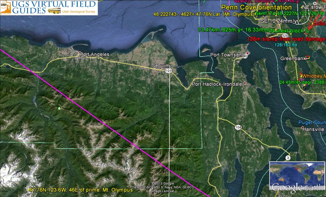
Let's CONSIDER how the 3 SEGMENT MODEL is useful in analyzing Penn Cove, where I will work for the Summer:
Penn Cove GLACIAL TREND is a diversion 253 degrees West, from the previous N-S track:
The trace indicates 17 degrees from an W-E track, which is the Inclination ANGLE of Pluto from the Ecliptic Plane of the Earth-Sun system. This fits the EQUATION: (90- 18)/18= 4, which would be added to 40.4N for Mendocino, CA, yielding 48.4N. The NEW REFERENCE in this area is Mt. Olympus at 47.76N Latitude, and using DIAGONALS, (72- 48.76)/48.76= .4736, and ADDING 47.76 yields 48.23N which is the Latitude is that of Penn Cove! Why have I used Mt. Olympus? North of this feature, the CRUST has taken a 44 to 45 degree turn, and the FOCUS of this is Mt. Olympus. This creates a NEW REFERENCE- the ORB North of 45N- and encompasses the Canadian CRATON, which is older (therefore LARGER in diameter), and PRECEDES the Mendocino to Cape Hatteras EXPANSION! This is a new REVELATION, and makes the North American continent OLDER than 4.096 x 1.024 billion years (the Binary Theorem PREDICTION).

CRATON Diameter establishes AGE, using 1.024 kilometer per m.y, since it is an UPLIFT, and NOT a TIDAL FEATURE, lying ENTIRELY north of the 45N FOCUS:

SUMMER WORK will involve Penn Cove, Whidbey Island, WA:

Penn Cove, Whidbey Island, WA is shown above and below:
SHALLOW water in Puget Sound EXHIBITS many DYNAMIC INDICATORS, off the west side of WI, in shallow water of the Puget sound and the Admiralty Passage:

Lake Perego in another ENIGMA- being a few feet abovve Sea level, but remaining BRACKISH, and isolated from the Puget Sound, except for storms. It will be ANALYZED since it is NORTH OF THE 45N Parallel (subject to a different REFERENCE (Mt Olympus):

CALCULATIONS confirm that Mt. Olympus is the REFERENCE for features above 45N! Also, the DIAGONAL equation (72- R)/R is APPROPRIATE for locating ANOMALIES, related to the LUNAR/SOLAR ratios near 2.0! I have yet to confirm 2.0 exactly as the correct ratio:

Western-most JUT of Whidbey is a new REFERENCE, similar to Mendocino, CA, but applicable ONLY to the Islands, MEMORIZE the 48.224196N Latitude:

VIEW to the West:
CALCULATIONS above indicate that PRECESSSIONAL CYCLES of 22,000 years create "jerks" in the SEA BOTTOM. This more likely exhibits CYCLES of 7.2 degrees each; this would be EQUIALENT to 800 units each, and NOT to a 3.6 degree SHIFT, as occurs at the Poles each 40.96 m.y. (SCALING by at least a 1000 factor)! OTHERS occur nearby, and this indicates that many CYCLES overlie older ones;

This INDICATES that there is a DIVIDER LINEAR, N-S, nearby; look at the San Juan Islands, which are in the shape of a DIVIDED Archipelago. Notice that the LINEAR cuts Smith Island, a RISE along a SINK:

N-S Linear is somewhat SUBJECTIVE, since it does NOT pass entirely through WATERWAYS! The difference in LATITUDE may be revealing, nevertheless. It is 48.611833N- 48.224196= .387637 degrees (x 111.111= 43.070777, likely 42.943, which is a fraction of Venus's 85.886km (3.3978d x 111.111).

Compare with the "JERKS" offshore Vancouver Island:

INTERMITTENT Tics are "JERKS" in a periodic COMPRESSIONAL Mode, which can be measured and TIME-CALCULATED:

REVIEWING:


THE CENTURIES PAST
Once when I was young and lusty, not as now with thoughts so musty,
Did I long and yearn to see beyond the veil.
I could sense the mystics saintly, in my mind’s eye e’er so faintly-
And the Spirits of the past did long prevail.
Will those thoughts forever grieve me,
Will they never, ever leave me,
Can you just, in time, believe me?
Say the Muses “Ever fail!”
Then I took to mountains, sensing Rocks and Petroglyphs- not mincing
Words which soon would ferret out the grievous tale.
How the Hittites in their rockwork, in their tasseled shoes like clockwork,
Wove the story and the tapestry, oh so pale.
And the ancient Jews before them- is it possible to ignore them?
Time and time I always swore them;
Say the Ancients “Stay the sail!”
Now I hear the music ghostly, it is in my psyche mostly,
And it penetrates so deeply in my armor mail;
Yet I quickly never lose it, with senility I peruse it,
And now lately I accuse it- of the loss of will and Spirit O so frail.
Did Sumerians, yes, so burly and the men who came most early
Feel the urgings and the mergings of the inner sounds that wail?
Quipped the cynics “Stop the tale!”
Lately I have turned to thoughts of Turkey- where the peaks and crests so murky,
Hide the musings of the past within their vale.
How the dağlar and their sounding, speak a plaintive language- founding
For the rhythms and the songs of humans’ trail.
Now I long to ever hear them, take their vibes and never fear them-
All those sounds will e’er endear them.
Speak the köyli “Hear the wail!”
Tell me now, Oh, all you mortals, ye who pass through all these portals,
Don’t you hear all of those whisperings and the sighing through the gale?
If you never, never feel them, then with Life you’ll never deal them
All the hands they should have gotten throughout the Pale.
Listen, listen- hear the longing; hear the earth’s mysterious songing-
Hear the creaking and the gonging.
Say the Muses “Never Fail!”
(dağ(lar) is mountain(s), and köy(li) is peasant(s))
Harold L. Overton
TO BE CONTINUED