Friday, November 13, 2009

Model, Horizontally (Hf) and Vertically (Wasatch), for Coriolis rotation around a Linear


The model shown above stands alone, and is actuated for the CRUST of the EARTH by an independent mechanical or thermal movement. The precursor LINEAR may be the Latitude line above which there is a lesser slowing of the EARTH’S SPIN (40N or 41S), compared to that in the EQUATORIAL BULGE, or it may be a smaller entity- such as the Hurricane fault operating on a local scale to produce circular river valleys and canyons.
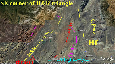
Above is the unbiased google Earth photo of the B&R-CP couplet, for a comparison with the model (uninfluenced by my interpretations).
Below are illustrated the rotation of both the CP regional and Hurricane fault local cells:


This model works on a vertical as well as a horizontal view, so that there is a gradual change in the location and elevation of the Colorado Plateau and associated Basin and Range province (vertically, where the Wasatch line is the divider). Similarly, there is a horizontal circular rotation about a sinking or rising magma chamber to produce an inscription about a centerline fault or other linear.

A SONNET TO THE EARTH

You are the Ground beneath my feet
You are the dust for all of LIFE;
Although you move with waves that meet,
Mankind’s precursors need the strife

Which e’er results from passage deep
Of heat and stress that strains us all,
You ne’er desist from dreamless sleep
While you move on this terrestrial ball

Designing now both rock and clay,
Which slowly change throughout the year
By the great turns of Moon and Day
From pulls of Sun whose sounds we hear

As multiples of your great rounds
Yield concordance with our own small waves
And surge of sunlit days for Males
While efforts are in tune ‘fore graves
But slight diverge from Moon’s Females.

You save our bones in your great rifts
Where Time may glimpse them when exhumed,
By seasons long and cyclic shifts
So we peruse them where they bloomed.

And E’en in death, we haunt the waves
Which saved us in your cyclic realm
And we record your moves from graves
Which all of life will ne’er o’erwhelm.

Harold L. Overton

Tuesday, November 10, 2009

Turkey's Anatolia similarities to the Colorado Plateau


This is in preparation. Most details from text, maps and photos are in earlier blogs. Scroll down.

Monday, November 9, 2009

Magmas rotate CCW, while cooling rock spirals CW


The Maui Island and cooling-shrinking Magma chamber is now rotating CW, producing shear friction HEAT- enough to produce the WAIKAPU vent which releases the energy. These are called rejuvenation vents, and always occur some million years after the primary eruptions (evidentally requiring this much time to build up the heat). They occur between the previously-active major vulcanism and nearby CRUST. Should the crust contain another nearby cooling volcanic peak, they both rotate in the same circular direction and "grind like gears in your transmission".

This document is being finally revised. Please scroll down for other topics bearing on this subject.

Basin and Range- Colorado Plateau couplet is rotating vertically as well as horizontally


This Analysis is being prepared; please scroll down to get the buildup to the conclusions.

Rotation of the Colorado Plateau


This document is being compiled; please scroll down to find the Preparation for it.

Hiking near Geological Anomalies in S. UTAH


As we complete our weekly hikes, I will place photos and Google Earth analyses for the pertinent features trekked in the field. Here is the initial hike and a model for the various movements of the Colorado Plateau- Basin and Range borderlands:
Below are photos taken during the Nov 4 hike, for fetures which we will hike to see in more detail later:


We will use the models shown below to have a plan of search for pertinent features:

We will be looking for anomalies, such as shown below:

We will be hoping to find laterally-lineated SLICKENSIDES, which show not only the horizontal movement of circular-rotating Coriolis cells, but the direction of movement, as shown below:

The hike on Nov. 11th produced the following photos and analyses. There are blocks of monzonite, which have been sheared by the CW-moving fault along I-15 freeway, via its secondary Coriollis rotations (reactionary cells). This action produces slickensides, which only are considered when found to move laterally (as indicated by horizontal striations).

Continuing to the south, along the B&R fault, we investigate the scarp to the south of the town of Harrisburg.
Above is a photo of lateral faulting, occurring in the Harrisburg, UT vicinity- a shear zone created by the CW rotation of the B&R fault. Below shows the area where this occurs. Note the canyon tracing parallel to I-15. This area will be hiked again, to search for other slicks yielding evidence of the direction of movement.
Search for slickensides will be made along the canyon paralleling I-15, since this is the gouge and shear zone for the B&R lateral fault.


This section of the blog will be used to show recent evaluations and remarks about hikes during the 2009-10 season. This will continue through May 2010.