DOUBLE BLUFF exhibits a transition of 12%, and we are attempting to determine whether this percentage holds for the one of GREATEST INTEREST: THAT BETWEEN the COLORADO PLATEAU and the BASIN-RANGE in Utah and ADJOINING Nevada. There, the transition lies betweeen the Parashaunt and Hurricane faults- a distance greater than 80 km (about 10% of the 800 km diameter CP.

The fault zone is EXPANDED to allow a view of the RISE BETWEEN the Virgin and Colorado Rivers:
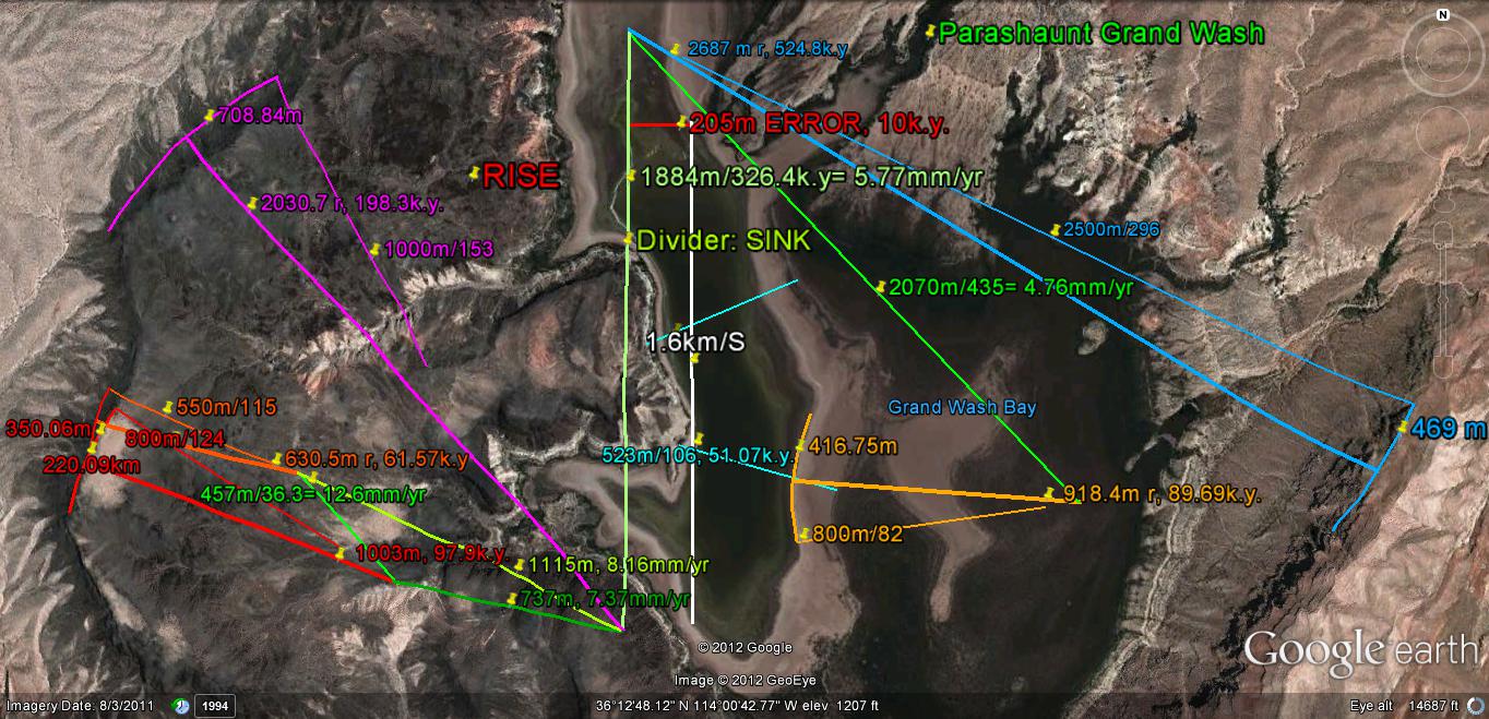
The OLDEST CIRCULAR ARCS (WIDEST and more irregular) have been distorted by subsequent events; this may be offset by SMOOTHING the largest continuous arcs (to eliminate the less important features occurring since the original partial circle expanded with time):
 It appears that the APPROACH for this GRAVITATIONAL ANALYSIS is correct, but we have to determine the ERRORS. The percentage of the AXIAL ROTATIONS is about the same- varying from7-13%- and pertains to the horizontal as well as vertical ARCUATE ROTATIONS of the CRUST. Remember that several measurements indicate that the transition relates to the RISING-SINKING of MILANKOVITCH CYCLES, as well as to the relation of densities contrasts, thickness of the crust, and DIAMETER RATIOS of various measureable features (all of which have the 1.6 ratio: Basalt/sedimentary densities= 4.0/2.5, for continental rock vs. OCEANIC THEOLITIC average CRUSTAL COLUMN BASALT; 40 km/25 km for thickness).
Another Protrusion into the Puget sound is Admiralty Head, which orients E-W:
This is a prominent HEAD on Whidbey Island, and it is adjacent to several features:
1. Crocket Lake- a SINK:
2. a transition zone, considsting of a lowlands- where the Seattle Pacific college is located;
3. Crocket State Park- a RISE; and,
4. Admiralty Bay- a semicicle, with the offshore current proceding CCW (salmon move north in this popular fishing spot).
I have previously analyzed this feature 5 years ago, and we will compare my conclusions to that subsequent to finding that ANALEMMAS and VERTICAL-LATERAL RISING and SINKIING DOMINATE the COASTAL MOVEMENTS:


These are interesting HIKES, and are easily accessed near the Keystone FERRY TERMINAL. You can walk through the RV Park without fee. Park on the hiway shoulder across from the terminal:

A NEW REFERENCE for the North American QUADRANSPHERE- Qsna, is shown BELOW to indicate that added information is found by the DAILY SATELITE WEATHER GLOBE, from ATMOSPHERIC TIDES- which perform simiarly to EARTH TIDES. This can be used in a GENERAL SENSE, to obtain movements from day-to-day that would occur on a million year SCALE in the EARTH'S CRUST:

The UNLINED VERSION shown below can be used to eliminate my ANALYSIS:

We will PROGRESS to TOMBOLO FORMATION and that of larger CAPES- such as Good Hope and Mendocino, NEXT. Those who EAGERLY AWAIT THIS must appreciate the FIELD WORK!


Fartherest north SPIT ARC is ELLIPTICAL, with a continuously-smooth WATERLINE:


Formation of a NORTH-MOVING TOMBOLO is found at DUGUALLA Bay, and on thre Oct 6-7 SATELLITE WEATHER MAP, in th form of a"TIT" moving north of South America within one day:
 Within a few hours, this CIRCULAR FEATURE- SOOUTH AMERICA will evolve into an ELLIPSE, and later form a "TIT" moving northward toward the Gulf of Mexico- a LOXODROME or meridian, under GRAVITATIONAL INFLUENCE:
 This PROGRESSES throughout the day, into an an ADJOINING (SHEARING, ROTATING) ARCUATE CCW-RISING LOW PRESSURE "TIT" CELL:
SIGNIFICANT CHANGES OCCUR in the ATMOSPHERE, which would happpen on a KILOYEAR BASIS on the EARTH'S SURFACE. Consequently, we can view the PROGRESSION of ARCS, CIRCLES, ELLIPSES, and WHOLE CONTINENTS during a day's viewing!
 Continuing for a DAY'S VIEWING:
LATER:

COMPARE ATMOSPHERE TIDES with earth tides which have formed the PROTRISION (TIT) south of Dugualla Bay:


Below is the GOOGLE VIEW:

And the CIRCULAR POND (artificially-formed in the last century) has been contrived by LATERAL GRAVITATIONAL ROTATION:

Stay Tuned!