The latest volcano is that of Veyo- some 10,000 years ago, and it is on the circuit of a series of “JERKS” which have passed through the area in the last 2 m.y. All of these fit a PATTERN- that of the ROTATION of the region encompassing the vulcanism from the Leeds volcano of about 60 k.y. to the Virgin River bend at the site of the dam on the river near Washington Fields:
VIRGIN BEND to Shnabkaib Hill and beyond:
The Washington FAULT is very near this CANYON. Notice that the "S" indicates RISING- which obviously is not the case. This occurs when there is an OPPOSITION to the rules- in this case, a CCW rising bluff to the east. The occurrence is SUFFICIENT to search for a DRASTIC ANOMALY- the 1 m.y. FAULT:
The "MIMA MOUNDS" would not be noticed, except for the groundskeepers of the GREEN SPRINGS GOLF COURSE:
They occur whenever there is COMPRESSION- CAUSING a RIPPLING of the CRUST in ELLIPTICAL-DIFFRACTION PATTERNS:
MIMA MOUNDS above, are found wherever there is GRAVITATIONAL CHATTER= d(JERK, da/dt)/dt, such as in the Mima Mounds State Park, WA, near Little Rock on I-5:
Thes make EXCELLENT GOLF COURSES, since they have already-formed TRAPS and obstacles:
Maximum temperature was 78F, during the NEW MOON of Feb/2013; this has risen, and should be monitored to determine the rate of T increase. Eventually the magnitude will rise to boiling- 212F- and this will presage RISING of an EXTRUSION! The crack across the pavement delineates the traverse of WASHINGTON FAULT; this is a slow-moving fault, CCW on the east side, and has broken a property owner's SLAB south of I-15; the red print above shows the crossing. My crude measurements indicate a rise of 6F in 3 years, or 2d/year- yielding boiling in134 years: 2147!
This GOOGLE EARTH photo exhibits the feeder street in Washington City, UT, where the "Boiler" has continuous flow- supplying warm water to the city:
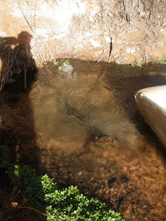
Digital photos above and below were taken at times related to the New Moon- which should create heat of COMPRESSION, as opposed to faster flow during the FULL MOON (EXTENSION, allowing cooling with wider fractures):
Below photo is at RIGHT ANGLES to the one above:
UNDERSTANDING EARTH TIDES is made simple, by watching the changes on BROAD SCALE Weather MAPS- such as publishedd by NASA daily:
This is shown BARE, so that you can make your own APPRAISALS:
Once upon a MIDNIGHT dreary, as I pondered weak and weary,
Over many a quaint and curious VOLUME of forgotten LORE,
As I nodded, nearly napping,
Suddenly there came a tapping, as of someome gently rapping-
rapping on my chamber door.
"Tis some visitor" I muttered "some late visitor, rapping on my chamber door;
Some rare visitor rapping on my chamber door-
Only this and nothing more"
I will appraise the CRACKS ALONG the WA Fault- they should be in POLYGONAL CONFIGURATIONS; the crack in the roadway should ALIGN with the WA fault:
The ROTATIONS-SHEAR is noticeable, not ony because the GROUNDS are kept mowed, but since the FIGURE 8, with accompanying TIT protrudes to the west:
I will explore this DRAINAGE- which is on the east side, and it exhibits the fault SPLAY:
The "BIG PICTURE" allows an overall PERSPECTIVE, but it is not too accurate:
The better way is to follow the VOLCANOS, since they are more PROMINENT:
Look again at the various POLYGONAL BLOCKS:
A WIDE SCALE SHOWS how Sand Mountain is a TIT, PROTRUDING between 2 VOLCANIC CYCLES;
We'll try to solve the riddle of the 2x MULTIPLE of the AGE, shown on the creek path:
NOMENCLATURE may be found in the FOLLOWING INSERTION:
Above and below NASA photos relate to the UNUSUAL STORM, in the NE USA- named NEMO, occurring 7-9 Feb/20013; this CATASTROPHE was a 100 year or more EVENT. I use this portrayal for nomenclature:
The GENERAL ROTATION of hills-sinks is shown in the below TRIGINOMETRIC DIAGRAM:
 A CASE I have investigated is shown for the SAN JUAN ISLANDS- where there is an ellipse of 12-13 islands, which has been shoved to the west:
You see how a MINOR POLYGON is part of a MUCH LARGER FEATURE- creating HEAT LOCALLY, and VULCANISM on a much larger SCALE! The difference is the TIME INTERVAL, with small heating building up to VAST TEMPERATURE CHANGE on a million year scale.
Compare the polygons and "twist" of the YELLOW KNOLLS with CHECKERBOARD MESA Zion NP:
Checkerboard Mesa confirms that the YOUNGER FEATURES have increasing number of sides to the POLYGONS; this indicates that LATERAL GRAVITATION MOVEMENTS occur more noticeably with INCREASING PROTRUSION! Gravity causes the ROTATION, while the DIRECTION is from the CORIOLIS "TWIST"! It appears more and more that CORIOLIS FORCE is created by gravitation.

CRATER LAKE:
Let's see how this "plays out" with a VOLCANIC EXTRUSION-PROTRUSION such as Veyo, north of St. George. UT:
This adds CREDENCE to the ANGULAR ROTATION RATE CALCULATION!
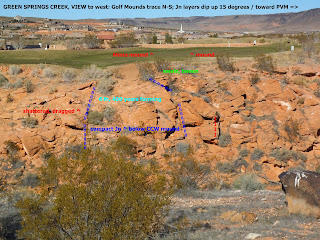
EAST OF THE DEVELOPMENT ABOVE is the creek which exhibits a FEATURE bebeath the MIMA MOUNDS:
Above is the SIMPLEST-SMALLEST ROTATION underneath a MIMA MOUND; this is more correctly "JERKING" of 10 SEGMENTS. UNKNOWN is whether the 400 year sequence occurs simultaneously. Below is the UPLIFT surrounding the basin, of a 100,000 year AGE:
Yellow Knolls trail occurs north of the Green and Warm Springs emissions, and is the POLYGON EDGE of the BASIN in which occur smaller polygons of a younger ROTATION. Notice the variation of 4 LINEAR SEGMENTS to 6, as the outcrop varies from VERTICAL to SLANTING; this makes it appear that behind a simple QUADRANGLE there are hidden polygons with more sides than 4. Another INTERPRETATION is that GRAVITATION ROTATING-SHEARING-FRACTURE PLACEMENT is more likely, the higher in elevation is the outcrop:
I have been concentrating on ARCS, and it seems that MOSTLY, they are EXHIBITED on a very small scale, as a series of "JERKS"!
EROSION has not been able to eliminate the straight line LINEARS, and they have over a short time interval remained as indicators of POLYGONS (Decagons, below):
The PATINA and discoloration occurs wherever the fractures allow CAPILLARY WATER to introduce Iron and Manganese:
We'll have another FIELD TRIP here, STAY TUNED!


