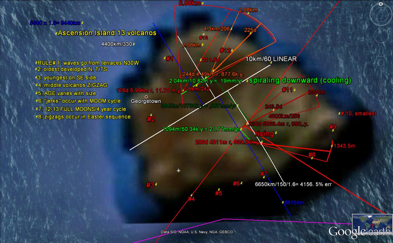
Ascension Island can be considered similar to a "ROGUE WAVE" in NAVAL TERMINOLOGY; it has formed as a result of 2 interfering CRUSTAL WAVES (the RATIO of viscosities of Earth's CRUST/WATER is near (10) exp+10, and a seawater wave developing in .3 days is equivalent to 100k.y. for CRUSTAL ARC SHEARING). It is progressing to the NNW, with time, and exhibits original older arcuate terraces offshore, with SUBSEQUENT smaller VOLCANIC CIRCLES (which should be ignored- using the "MEAN" locations between juttings and coves). 1.2 m.y. Ascension I. should have 12 (100k.y.) extrusions within the estimated LIFE greater than 1 m.y.


A LARGER VIEW allows INTERPRETATION of the SHEAR CIRCLES (SEAMOUNTS, COASTAL BORDERS) for calculation of the TIME INTERVALS involved:

MAR, which is lined in black, exhibits a GAP in the TRACE, so that the INTERFERING EARTH TIDAL WAVES absorb the GRAVITATIONAL ENERGY:

The island exhibits at least 13 separate extrusions, and we will solve the SEQUENCING of this OBVIOUS "ZIGZAG" PATTERN, by finding the development of FULL MOONS, through 19 years of time- as found by the RELIGIOUS MONKS' INCENTIVES:
 I have left un-scribed the 19 year SEQUENCE, requiring LITERATURE SOLUTION to the ZIGZAG SEQUENCE (shown by the Catholic Church and their diligent MONASTARIES-SCIENCE ORIENTED MONKS):
I contoured the calculated TIDAL MOVEMENTS RATES, and they are REVERSE to the normal SE LOW and SW HIGH. This determines that 2 ignored factors are influencing the movements:
1. CORIOLIS FORCE acts oppositely to that in the northern hemisphere; and
2. The WAVE TREND is NNW (N30W), and the EARTH COMPASS REFERENCE should be shifted 30 degrees, or 60 degrees in the ORTHOGONAL DIRECTION. I chose the simpler 30 rotation, and it PROVED to be the WRONG selection!

Consequently, I found that there is considerable ERROR with this ESTIMATION, and I used the RADIUS of CURVATURE as a DETERMINANT of EXTRUSION SEQUENCE. This does not require TIME INTERVALS, and the relative positions are indicated in the above and BELOW photos. The first SIGNIFICANT FINDING SOLVES ZIGZAGS; they are the result of spiraling, where the alernation from east to west is merely ROTATION CW (RISING, SOUTHERN HEMISPHERE) for more than a single spiral- where the movement is around the circle and NOT ACROSS IT!
 There are more SIGNIFICANT FINDINGS:
1. The BINARY THEOREM NUMBERS, RATIOS, and sequences APPEAR;
2. The ISLAND is SEPARATED by a DIVIDER (WASATCH LINE), and it denotes the AXIAL PORTION as DISTINCT from the PRECESSIONAL CYCLE (similar to the BASIN-RANGE, B and R)- the irregular SE ragged coastline;
3. Yellow lines denote the ORTHOGONAL DIMENSIONS, which are 1.6 to 1 in length. This determines the PRESENT CENTER of ROTATION; and,
4. The diameter x pi yields the CIRCUMFERENCE, and this C/TIME of INITIATION (1.25 m.y.) finds that the EDGE ROTATION RATE= 40.96 mm/yr. (a harmonic of the Moon's GRAVITATIONAL INCIPIENCE of 4.096 b.y.).
I have NOT SORTED OUT NUMBERS, RATIOS, yielding 1.6 from the other POSSIBILITIES: pi/2= 1.57, Earth Orbit days/Venus= 1.62, and the GOLDEN MEAN phi= 1.618. These difficulties all lie within my EXPECTED ERROR of 5%, and I have not RECONCILED the variation with the error.

The position of the FULCRUM has my usual errors, and the 5% must be treated with charity.
Now compare Ascension I. with Saint Helena island some 1127 km to the south (at least 100 m.y older: 1127/10.24mm/yr). This volcanic island is NOT A "ROGUE WAVE", but is located inside the spread of a MAJOR TRANSFORM- formed from POLAR ANGLE CHANGE of 3.6 degrees latitude or 400 km each 41 m.y. (1/100th of the earth circumference, or 360 degree circle). Note that the island is a more NORMAL EXTRUSION, now dormant, forming its ARCUATE BEACHES by PERIODIC "JERKING" of similar magnitudes (similar arcs, or similar TIME INTERVALS). "JERKS" are created by the difference in the MOVEMENT RATE of the north from the south BLOCKS (on either side of the island):

The TRANSFORM SPREAD is from 72. degrees LATITUDE in the NE Pacific, to 1.8 degrees in the South Atlantic (4:1, as predicted by the BINARY THEOREM):
These ORTHOGONAL TRANSFORM-PERPENDICULARS may be GENERALIZED with ATMOSPHERIC TIDES- as seen on DAILY SATELLITES:

First, the north side, where the BINARY VOLCANICS may be viewed:
 NORMAL adjacent VOLCANICS (EXTRUSIONS) occur SEPARATED FROM EACH OTHER IN TIME, by 4:1, e.g. 1 m.y, then 1/4 m.y. This is the case under consideration:
Then the south side (these must be separated, because of the lost view on a larger scale- frugal photography):
 BELOW is an EXPANDED VIEW- SE CORNER, where the Basin and Range IRREGULAR COAST LINE solves the JUXTAPOSITION of the ORIENTATION of the development, compared to the north latitude CP-Basin and Range- which orients E-W (this is a 60 COMPASS degree SHIFT FROM NORTHERN TO SOUTHERN HEMISPHERE):
Notice the "TIC MARKS", which I have photoed in the CONCOMITANT Basin and Range-Pine Valley INTRUSION, for a hike-able SCALE:


Following photo was taken about 2 km south of the above PVM (Pine Valley Mtns.) UPLIFT; look carefully and you will see the vertically-arranged TIC MARKS. These occur on many scales- from this 2 meter block of MONZONITE, to mountains for the Atlantic Islands:

This should be compared to SUTTER BUTTES, CA- which is another UNSOLVED EXTRUSION MECHANISM-SITE, according to the literature. I have worked on this one sufficiently, in the field and on GOOGLE EARTH, to see the similarity. At CRITICAL LATITUDES, where an INSTABILITY OCCURS (a HARMONIC 9 degrees of latitude, or its coordinate 40N of the EARTH'S POLAR WOBBLE- according to the BINARY THEOREM, 9 x 40 = 360), the earth develops FRACTURE OPENINGS- which allow the normally HOT BASALT at the top of the MANTLE to simply EMERGE (NO MANTLE PLUME, HOT SPOT, or other fantasy is necessary):
Mendocino, CA ridge and rotation occurs a bit north of the 40N latitude:

Notice that there are at least 12 ARCS-VOLCANIC EXTRUSION SITES, subject to my SUBJECTIVITY; a LINEAR MUST BE FOUND in the center to allow the SEPARATION of separate extrusions:

The SHEARING ARC is shown in RED, compared to WHITE for the Ascensions; close inspection shows the ARC TRACE INTERSECTIONS:

SIMILAR to all EARTH TIDAL MOVEMENTS, the arcs are CURVILINEARS, which appear as straight lines for sufficiently LONG (OLD) TRACES:

Photos taken in the field show the beauty of this ANOMALOUS EXTRUSION SITE:


There are GUIDED TOURS, for those who want to verify (or TAUNT) this EARTH TIDAL MOVEMENT:
Oh, the WRATH of the subjective-
BREAD and BUTTER for the DEFECTIVE!
They much MALIGN the low DETECTIVE,
While introducing MERE DIRECTIVE.
Instantly you should think GEOLOGY,
Which masks behind the NEW ECOLOGY;
Foisting massive TERMINOLOGY,
While relying mainly on THEOLOGY.
Oh, the WRATH of the subjective-
BREAD and BUTTER for the DEFECTIVE!
They much MALIGN the low DETECTIVE,
While introducing MERE DIRECTIVE.
Instantly you should think GEOLOGY,
Which masks behind the NEW ECOLOGY;
Foisting massive TERMINOLOGY,
While relying mainly on THEOLOGY.


Help in understanding all this TIDAL MOVEMENT is found in an EASILY-VIEWED LOCATION- the SATELLITE VIEW of EARTH:

This PORTRAYS ATMOSPHERIC TIDES- which operate under similar RULES as LAND TIDES and WATER TIDES. Some of these are shown above, and an expanded view is shown below (DON'T EXPECT ANY DETAILS- ONLY GENERALITIES):
