
AGE-DATED (TIME INTERVALS):

ABOVE ARE REVERSE "S" SHAPED CONFIGURATIONS, but the FIGURE 8 is arranged N-S; BELOW it is also N-S, but in the accepted S SHAPE- which will form a SWASTIKA when fully developed. There is useful information in the ORIENTATION-ROTATION DIRECTION: Backwards S indicates CW, and S for CCW (e.g. there is CW movement around Sand Hollow, via the Virgin River shear to the EAST- the convex northern portion is moved by SOLAR eastward, with the southern moved by LUNAR to the west). The most DAMAGE occurs at the NE- where the shear arc is advancing to the NE.


The MULTI-SCALING of GRAVITATIONAL LATERAL ROTATIONS is shown below for the Colorado River- showing that this occurs NOT ONLY on a k.y. scale, but that it can be CHECKED by calculating the TIDAL MOVEMENT RATE:


TRAPEZOIDS are identified by the EXHIBITION of 2 or more LINEARS- which occur near 2 RIVERS' INTERSECTIONS. This is a VALUABLE FINDING, allowing the trapezoid and ENCLOSED ANALEMMA-FIGURE 8 to be easily located. Along with this, there will occur ANOMALOUS TEMPERATURE or WATER COMPOSITION- such as the BLUE SPRINGS near the CONFLUENCE of the Colorado and Little Colorado Rivers. Remind me to regale you about my and Col. Glenn Wassom's TREK DOWN HORSE CANYON (to the east) in search of the FABULOUS HEALING WATERS!

Since the above ORTHOGONAL LINEARS indicate that a LOCAL ANOMALY causes the appearance of the BLUE SPRINGS, I made an AGE ANALYSIS to find what is causing it. The below photo shows that there is VUCANISM NEARBY- resulting in a very FAST SHEARING ROTATION. This indicates that there is a FULCRUM with LOW TIDAL RATES, surrounded by FAST RATES at the PERIMETER:

When I trekked the INFAMOUS HORSE CANYON TRAIL, I was bent on SURVIVAL, and never noticed the NEARBY VULCANISM. It is young- near 1 m.y.- hence the drastic cliffs and chasms I had to endure.

Below is the start to UNRAVEL the SEQUENCE FORMING the TORTUOUS PATH of the Colorado River, from Lake Powell to its EMERGENCE in the Basin and Range country:

Although the NAVAJO UPLIFT (DOME) calculated AGE is not too accurate (near 1 m.y., subject to UNEVEN EROSION and DRAINAGE), it reveals ANALEMMA CONFIRMATION of the RAGGED SE portion- compared to the REGULAR EROSION of the NW 20.48 mm/year AXIAL ROTATION. This is the NORMAL ARRANGEMENT- think IRREGULAR BASIN and RANGE, COMPARED to the FLAT-AND-LEVEL COLORADO PLATEAU. We start with the SIMPLEST YOUNGER UPLIFT, which is easily seen on GOOGLE EARTH, and which is a DOME WITHIN A SINK. Next we progress to a wider view, allowing the Navajo dome to guide us to an OLDER-WIDER GYRATION of the POLAR WOBBLE, which has formed PARALLEL CANYONS (GRIDS in the larger sense) preceding the ANALEMMA FORMATION- shown by the REVERSAL of CONVEX ARCS as indicated by the river valleys CURVATURE):

Looking ahead- with passage of TIME- there is a DRASTIC RE-ORIENTATION of the Colorado River PATH, as it makes a REVERSAL after the TRIPLE JUNCTION of the Little Colorado; this is the start of a NEW ANALEMMA DEVELOPMENT (new block of crust, as defined by the TRAPEZOIDAL PERIMETER- whenever 2 rivers JUNCTION):
A "WHITE LINE" is placed where there is a ARC CONVEXITY REVERSAL- indicating that not only is there a NEW ANALEMMA and separate BLOCK of CRUST, but that a FIGURE 8 DEVELOPMENT can be expected (note the trapezoidal PARIA PLATEAU and its separation from the LAKE POWELL PARALLEL CANYONS):


A SIMILAR TRAPEZOIDAL ARRANGEMENT, above, can be found from the pattern of the HORSESHOE BEND- near the town of Page, AZ, which can be seen at an overlook just south of the city area. This is ROTATED 90 DEGREES, below, so that one can see the UPLIFT east of the river bend. This FEATURE is TRAVERSED upon floating downstream of the Lake Powell dam, and it is in the shape of an ALMOST FIGURE 8- almost eroding the separating canyon walls:

HORSESHOE BEND by GOOGLE EARTH:

This is AGE-DATED for smooth arcuate PORTIONS:


I have RE-ANALYZED this feature, to UNDERSCORE the COMPLEXITY. NOTE that there occur 12-13 ARCS SURROUNDING the ANALEMMA- indicating the number of FULL MOONS/YEAR, which require many REPETITIONS to scribe these on the EARTH CRUST OUTCROPS:

I have taken 2 float trips to doocument these VARIOUS ANALEMMAS-FIGURE 8s, as to how they inscribe the CANYON WALLS with ARCUATE-CIRCULAR SHEAR FRACTURE ETCHINGS (some more Madeira, my dear?). The vertical ARCS are perpendicular to the horizontal or LATERAL ROTATIONS (CCW RISE at the surface is acccompanied by a CW ROTATION in the vertical walls- 2 GEARS MESHING require that they be rotating oppositely, even when one is PERPENDICULAR to the other's PATH).

ABOVE Hurricane FAULT, Hf, access is located at the Honeymoon Trail, UT AZ border- accessed by rough road- and the analemma is accompanied by a shear canyon- developing a ROAD FRACTURE at the top:
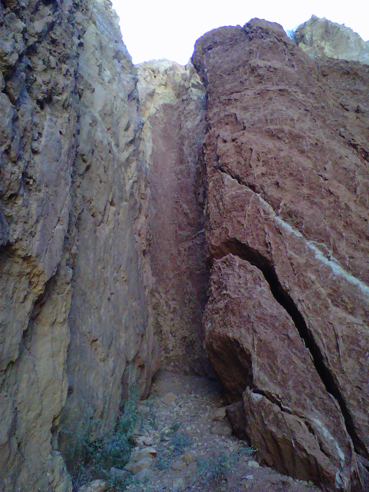
BELOW is a view of this advancing CCW Canyon:

This canyon RAPIDLY NARROWS- advancing by about 1-2 inches/year:


EROSION has not been able to offset this RAPIDLY-SHEARING LATERAL MOVEMENT!

Below is the ARCUATE FRACTURE APPROACHING the Honeymoon Trail, which will decimate the road within 100 years!

Larger VIEW: NOTICE the CIRCULAR CLIFFS- shaded for the northern portion, but sunny for the southern FACE (THIS IS A FRAGMENTED FACE of the HURRICANE FAULT- moving CCW from the Fort Pierce tributary with a kilometer diameter ARC); 1 km/17.48mm/yr= 57.2 k.y./64 "jerks"= 894 years/jerk, compared to 666 for the measurements made by chaining the vertical inflection separations (in the CANYON, by 2 chainmen):

We measured the DISTANCE between SUCCESSIVE VERTICAL CONTINUOUS SHEER SCARPS (INFLECTIONS separate "jerking" ROTATIONS- you can see 4 within the photo, of about 15 degrees change each- that's 24 intervals/circle; THERE ARE MORE, ACCORDING to GOOGLE EARTH):


The ABOVE FAN is enlarged to show that it was not in contact with the air, at the time of its arrangement. USUALLY, GEOLOGISTS suggest that AIR COOLING forms the perpendicular-to-the-outside-air COOLING CRACKS:

This FINDING allows insight into the Virgin River presentation, near the confluence of ASH, LAVERKIN, and VIRGIN RIVERS- just to the east of the the MYSTERIOUS BASALT FAN-ANALEMMA (see 4th photo, ABOVE):

Due to this entity being created by the MOON-SUN GRAVITATIONAL SHEARING CYCLES, there will occur 12-13 ARCS SURROUNDING the ellipse (full moons per yearly cycle). These occur with shearing of the SURFACE ROCK- ALLOWING DRAINAGE to CREATE CIRCULAR PATHS. VIEW COLORADO RIVER AGE-ANALEMMA FORMULATION, CAUSED BY the MOON-SUN GRAVITATIONAL ROTATIONAL-SHEARING CYCLE:

BELOW is a WIDE REGIONAL VIEW:

I will explore the Colorado below Glen Canyon Dam- a new Tunnel allowing rafters and fishermen to access the cold waters emerging from BOTTOM WATERS (rainbow trout HABITAT):

The MUCH LARGER ENTITY is the AGE-ANALEMMA FORMULATION causing the river to make great TURNS. Solving this requires a "SMOOTHING" of the CIRCULAR PATHS (ARCS), since small later subsequent events create both IRREGULARITIES (BAYS OR OPPOSITE INTRUSIONS):

.jpg)
The TRACE NEVER CONNECTS; the DIAMETER SIMPLY INCREASES:

MANY CASE HISTORIES PORTRAY that RAPID CHANGE REGIONS display the analemmas. There is a ROTATION, with SPIRALING about a FUCRUM- with the smallest TIDAL RATES at the center and the largest at the EDGE (OUTER DIAMETER, or circumference of rotation). The ELEVATION RATE CHANGE is always smaller than the LATERAL RATES; e.g. the CONTINENTS EXPAND LATERALLY at 1 mm/year (4096 km/4.096 b.y.) since the MOON TIDAL INITIATION, but the upward movement is MOSTLY OFFSET by EROSION, and the elevation of a continent is rarely greater than 2 km, AVERAGE:

The FIGURE 8- INCOMPLETE- OCCURS in the Atlantic Ocean as a SILTATION CURVE; this is VERY SUBJECTIVE, but can be seen as a TRACE very near the MID ATLANTIC RIDGE (MAR). I have not found this siltation trace over a wide area in other oceans- indicating that the MAR has the GREATEST ACTIVITY over a WIDE REGION, than all other SMALLER ENTITIES:

I have repeated my analysis several times, to eliminate SUBJECTIVITY; the only consistent finding is that the SOUTHERN AXIAL CIRCULATION and DIAMETER RECURS. This indicates that the CURRENT FEATURE STARTED with the 256 m.y. PTr (Permin-Triassic EVENT BOUNDARY) SEPARATION of Africa and NA:

THE QUESTION NOW ARISES: "WHAT is the relation of the ANALEMMA to the CURRENT MAR ACTIVITY?" It appears to depart from the WELL-DOCUMENTED MOVEMENT of the N-S 41 or 20.5 m.y. separation of TRANSFORMS and the 25 m.y. E-W MOVEMENTS. Incidently, the TRANSFORM SEPARATION is 7.2 degrees of latitude at the CA coast, and this results in 1/50th of the EARTH'S CIRCUMFERENCE (3.6 degrees is 1/100th- 400+km, of 40,000+km- the case of the Atlantic: HALF of the Pacific separation):
PREVIOUSLY, I have found that the ANALEMMA is a HARBINGER of VIOLENT ACTIVITY- WHETHER VOLCANIC, SIGNIFICANT EARTHQUAKES, or WEATHER:

EXPANDED:

The DESTRUCTUVE SANTA CLARA RIVER STORM occurred AFTER one LUNAR MONTH of the WARNING- Sept 11!

The CENTRAL AMERICAN SPIRAL occurs at the SA-NA BOUNDARY, where the TIDAL RATES change in this SW block- compared to the NW North American block, with its 20.48 mm/yr shove to the WEST:

Both LOOP CURRENTS and CRUSTAL ROTATION occur in the GULF of MEXICO ANALEMMA:


A much smaller but SIMILAR ANALEMMA-FORMING CASE is exhibited to the NW in ZION NP, adjacent to the Kolob Reservoir Road- where somewhat younger RED ASH has formed a VOLCANIC PLUG- mined for road mettle:

This is located within a SINK, SURROUNDED by FORMIDABLE CLIFFS of Jn, which EXHIBIT MIMA MOUNDS (somewhat older than the ones I have presented in WA State:

ADJACENT RISE (EROSIONAL REMNANT) is part of the WALL OF CLIFFS, LOCATED in the ROTATIONAL CENTER of a 2 m.y. ELLIPSE- which includes ZION NP:

ABOVE DIGITAL PHOTOS are embellished by VIEWING GOOGLE EARTH:
 NOTE the MIMA Mounds- which are ROTATION-COMPACTED, and RESISTANT to erosion more than neighbors.
This is AGE-DATED via GOOGLE EARTH:

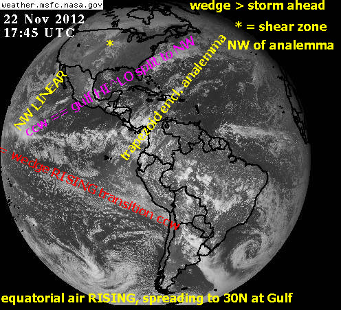
A NOTE ABOUT ATMOSPHERIC GRAVITATIONAL TIDES:
The lower atmosphere, below 10.000 meters effects almost all of the changing weather- such as storms, heat and moisture. This portion is readily viewed in EARTH SATELLITE PHOTOS. These are available from NASA, as hemisphere photos each 3 hours during sunlight. Below is one which allows predictions to be made:

It is difficult to see the "BIG PICTURE" from the ground surface, but occcasionaly I am lucky:

PVM (Pine Valley Mtn,) can be viewed from the volcano behind my house; this relates that there will be another destructive storm before the next NEW MOON- Jan 2013:


I will follow this daily, until the NEW MOON of 14 Dec/2012:
3 hours LATER:

STAY TUNED!