Jupiter, with its 1.304 degrees Inclination, is correlated with the VULCANISM of Kilimanjaro to Goma- to the West, via its Gravitational Positioning of an Asteroid, to create HEAT! Nyiragonga, near Goma, is the MOST ACTIVE (Jan 17/2002 last Killer), and the Tidal Movement trend is to the East, for the West side of the Rift (also for the East at Kilimanjoro). Convex arcs point to several Directions- indicating that RETROGRADE action of the Moon is involved (Moon moves reverse to the Sun by 50 minutes daily). Nyiragonga is VOLCANICALLY ACTIVE because it is at the Fulcrum of a Circular Arrangement of Hills being TIDALLY MOVED to the East, by the Combination of our Moon and a Jupiter-Asteroid 4 body Gravitationally-locked "Fix"! Our Moon inflicts N-S slices, which is the case at Lake Malawi.
Preparatory to Analysis, view the Nile River to the Red Sea ARC and SLICE:

BIG PICTURE of Red Sea Linear (which is expanding E-W, releasing Heat and Oil):

Note the Nile Arc and SLICE of the Gulf of Aqaba and the Red Sea:

300 km Gulf Slice lies north of the Red Sea 2000km SLICE:

2000 km is a Tenth of the Hemisphere; GEOMETRY is a Major Factor in placement of the RIFTS of our Earth!
BIG PICTURE, showing how the Red Sea LINEAR is related to the ORB of Africa - pink half Ellipse (North of the Equator- which Latitude is another SLICE):

Above ELLIPSE of the Africa to Arabia DESERTS is a RISING feature- Split by the Red Sea; find the RATIO of the Distances of the West/East parts! Ratio= 2.96 or 1.96, indicating OTHER Planets than Jupiter!
Use above Ellipse, Orientation, and SLICES Features to analyze the Malawi portion of the African Rift!


Namwera, Malawi, with SINK BELOW:


Lake Malawi is EXPANDING; E-W:

Above, Lake Malawi West is moving to the West, and it has SHIFTED more than 5 degrees (Asteroid, or MOON at 5.145 degrees Inclination?).
Diameters of the 2 parts of the Figure 8 are SUBJECTIVE, but this is a start to determine the Solar System Bodies which have created the GREAT RIFT; it PROBABLY is the Sun and Moon's Gravitational attraction- locally, with minor deviations creating the Bays, tics, and Islands!HEAT-GENERATING 60 degree Corner?

Photo above lies at the POINT of EXTENSION to the South!
Analyzing the Mulanje Massif to the South- which appears to be a BARRIER to the RIFT:

ANALYZE the lake to the North:

Finding the TIME INTERVAL, to form the Active VULCANISM of Kilamanjaro and Goma, requires MEASUREMENT of the Distance between them (and this yields 69.2975 m.y.):

The BIG PICTURE of the Lakes around Victoria is an ELLIPSE, where Lake Victoria is a HOLE- which is INSIDE the ellipse:

Only a SLICE is shown (via Lakes); now a Hole (Lake Victoria, inside a Circle of Lakes and Volcanoes), and a SLICE to the South (which is NOT super-imposed over the HOLE!). Width of the lakes is brought about by E-W Expansion (Movement in both Directions, without information about which is Greater)!
Look further to the South:

Looking WEST of Lake Victoria, the Congo River makes an ARC to the West, just north of the Equator:


While the REFERENCE for North America-USA is Mendocino, at 40.439N, the reference for Africa is the Equator at 0N and Lake Victoria; These are APPROXIMATE even Fractions of Earth's 180 degrees HEMISPHERE- showing the Small Error of the Exhibit!
Refer to Mt. St. Elias at 60N, and Mammoth Mountain, CA (1400 years ago, at 615AD), 50E of Natural Prime Meridian at 169.6W= 119.6W (actual= 119.0326W, Santa Barbara Ventura Fault is closer).

Mt. St. Elias is at the INFLECTION of the Turn west to Alaska (Bordering Canada):

Altogether, there is a PARTIAL FIGURE 8, oriented E-W, as with the letters OlO, found from Drainages, Lakes and Vulcanism!
Resulting Figure 8 has a Transition Zone, and the OVERALL APPEARANCE yields a tentative MODEL for the Earth, where ROTATING- SHEARING SEGMENTS create River PATHS and HEAT of Vulcanism- whenever there is sufficient SIDEWAYS MOVEMENT (lateral)! This is RE-SHOWN in the following E-W exhibit for almost all of Africa at the Equator:

Assessing the lakes MOVEMENT, to determine the ACTIVITY- view Lake Rukwa:

MOVEMENT is Fast, at 86 mm/year, and this may give a clue to the VULCANISM!
COMPARE this Couplet (Alkali Lake, Deep water Lake) with a smaller version at Lake Malheur-Playa Duo, Oregon. of a higher Dry CIRCULAR playa, and a fresh water one to its East:

Above exhibit is REVERSED, and this will be remembered as a Southern vs. Northern Hemisphere difference!

Better wifi:

TAGGED:

Google Photos:

SHAPE is ORTHOGONAL, and is it also Upside-down, and Reversed? If so, there is too much DIFFICULTY with this Comparison!
MISTAKE may be in the placement of the EQUILATERAL TRIANGLES, which must be determined by the Movement of the Lakes (Expected to be to the West for Bukwa, and for Expansion in both E-W directions for Tanganyika)! When CORRECT, the 86 mm/year will be the Rate of Movement of the HEAT BUILDUP- "creeping to the West, for Successive Extrusions"- a CYCLE with Creeping Heat increases before a Vertical release!
EXPANDING, notice the almost PARALLEL PINK LINES (within 7 degrees by compass), indicating that the VULCANISM occurs near the Lakes, and NOT BETWEEN!


Ratio of the 2 largest RIFT Diameters should determine the largest Solar Object creating the FEATURE! It is 1.3+ (accuracy within 4%, from my selection)- which is the Inclination Angle for Jupiter= 1.304 degrees; it is dimensionless, as is the ratio:

Geothermal MAP of Malawi:
Figure 6: Location of hot springs of Malawi. Symbols:
red >60°C; brown 50-60°C; orange 40-50°C; yellow 30-
Malawi River Shire bridge- where Hot Springs will occur at a Tributary or at a SCARP nearby:

Tributary of the Shire is a likely Hot Springs Location:


There are several 10,000 km lines; the two RED at South Iceland is the likely next Volcanic ERUPTION, above!
Geothermal Line from Malawi to Iceland is 10,000 km/338.64 degrees by Compass:
I took Data from Gt Exploration Reports, to find the Hot Springs at Mpatamanga- where the Transforms align with Iceland's South Coast (site of the next Volcano)! This MALAWI site has no Vulcanism, instead exhibiting an Anomaly at the Shire River- probably a LATERAL TRANSFORM!
Again, we have a Horizontal -, which is 90 degrees (of Earth's 360 degrees) removed from a Vertical I.
Importance is that a Horizontal SLICE, of the Earth's Crust, is accompanied by a Vertical Slice 90/360, or 10,000 km= 10/40 Distant. Again, we have a Horizontal -, which is 90 degrees (of Earth's 360 degrees) removed from a Vertical I.

Asteroid VIDEO, with Jupiter in the NE corner, occasionally, with its 11.86 year Cycle.

NOTICE the Shift between the 2 lakes; this is occurring because of the REVERSAL of direction of the Earth TIDES, where the CONVEX ARCS which were pointing Westward are now pointing EASTWARD! Transition zone, which is MOUNTAINOUS, is measured for distance and AGE of "Turn around" is shown below:

Searching for GEOTHERMAL Indications between the Lakes:

DETAILS:

ORTHOGONAL Red line shows the TIME INTERVAL and Trend of the Compression (Mountains' Grain) to the East! All TIDAL MOVEMENTS East of Goma Retrograde to the East- pulling the Crust open for Nyiragonga to ERUPT CONTINUALLY (NOW)!

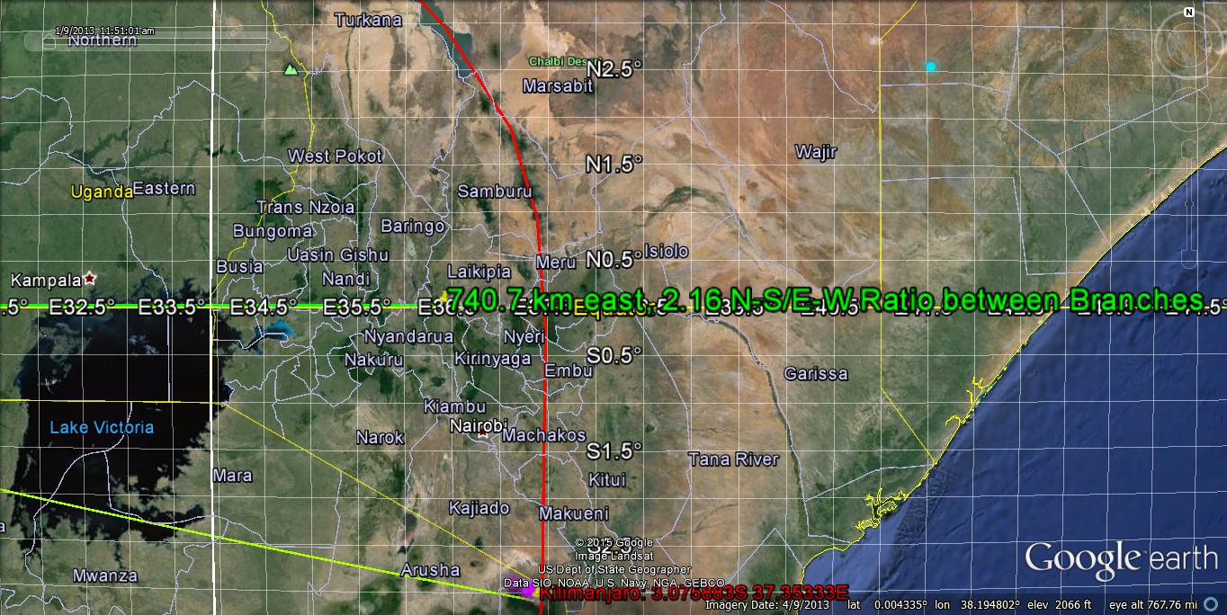
TEST of the ACCURACY of the Moon/Sun Ratio can be found with MEASUREMENTS of {(N-S)/(E-W)}. Similarly to Greenland, with its Subsurface Lake which is a HOLE- there should be Height/Width= 2.16!


This African rift analysis is VERY SUBJECTIVE, since there are several branches (splays) of the RIFT FAULTS, as shown below (representing ENLARGING ARCS to the East):

Lake Rukwa is younger, at 434 k.y., and has rotated 30 degrees CCW from the older Transforms:

Searching for a better exhibit, NW end of Lake RUKWA is expanded, using a Geographic map as a guide. There are two rows of PARALLEL MOUNTAINS, between the 2 lakes:


The BIG PICTURE is seen, when sinks or Depressions to the SW are incorporated:


Muchingo Mountains form a Ridge LINEAR, 1500 km length- which is a side of an EQUILATERAL TRIANGLE:


Part of the 1500 km shown is NOT in the Mountains; re-measuring, it is 444.444 km for the hilly portion- yielding an AGE of 27.77 m.y. It is assumed that the Mountainous part is the OLDER!
Calculated is the Cretaceous Time of formation of the Mid-African VULCANISM. This is younger than Iceland's initial vulcanism- from the MAR!
View the BIG PICTURE. showing the various LaGrange EQUILATERAL TRIANGLES calculated. Which is CORRECT?

Nyiragonga is presently ACTIVE,as is shown for the TREND to the East, below:

HOT SPRINGS found at Nkhotakota, on the West side of the lake, at 12.916667S 34.3E, are active at 125,000 years AGE (compared to 420 k.y. for the Lake's Regression since DRYING):

EXPANSION has produced the ANOMALIES, since the 420 k.y. date:

Formation of the River system, shown above, at 422,863 years Agrees well with the Literature's 420 k.y. Regression of the Cycle of Drying (termination)!


MAR is shown for COMPARISON, where the Creep to the West (followed by a 60 degree TURN) makes a LaGrange EQUILATERAL TRIANGLE- terminating at the Iceland VULCANISM:
TRIANGLE is formed by the MAR, a Transform, and England's East Coast:
ICELAND Critical Coordinates are shown below:

MAR cuts Iceland, above, and forms the LaGrange 60 degree Corner, below:

Notice that there is a GRADUAL TURN, not a sharp angle! This fits with the 80+ m.y. PRECESSION of the Sun's Tilt of 7.2 (7.25 in the Literature(! Iceland is a LONG-TIME FEATURE (Age Unknown for the incipience, but it is greater than 80 million years!).
Iceland is on the MAR- which divides the Earth; a 90 compass degrees ROTATION covers a Quarter of the Circumference (90/360 = 1/4th)- which is 10,000 km of the 40,000 km Circumference. Look in all Quadrants- 10,000 km- and there are ANOMALIES- such as the African RIFT at the Shire River (southernmost Hot Spring at a Transform), Maui Transform, Tanduska Meteor Lateral "knockdown", and the MAR at the Tropic of Capricorn!

What is the PRIME MOVER of the African RIFT and the MAR? Since the Movement is essentially N-S, the Moon is suspect, but the ORTHOGONALITY to our Sun must be demonstrated! The MILKY WAY moves overhead daily; could it AUGMENT? our Moon:

Remaining in the Milky Way System, the Big Dipper's Cup points to the North Star (Polaris), and we are getting FAR AFIELD:

To be Continued:
Dichotomy of the day:
"My Grounds are Cold, but the Coffee is Hot?"