
ABOVE PHOTO SHOWS THAT THE OLYMPIC PENINSULA HAS BEEN ROTATED AT LEAST 60 DEGREES TO THE NW, AFTER AN ASTEROID STRIKE CAUSED WESTWARD MOVEMENT AND ROTATION OF THE PENINSULA AND VANCOUVER ISLAND (BETWEEN 28 AND 41 M.Y. AGO). SIMILAR ROTATIONS HAVE BEEN LOCATED IN CENTRAL AMERICA, SAND MOUNTAIN, UT, AND AT THE JAN MEYER RIDGE NORTH OF ICELAND. THIS IS SUFFICIENT EVIDENCE TO DISPLAY MODERATE CONFIDENCE THAT LARGE ASTEROIDS CREATE CONSIDERABLE STRUCTURAL GEOLOGICAL THRUSTING, SHEARING, AND UPLIFTING.
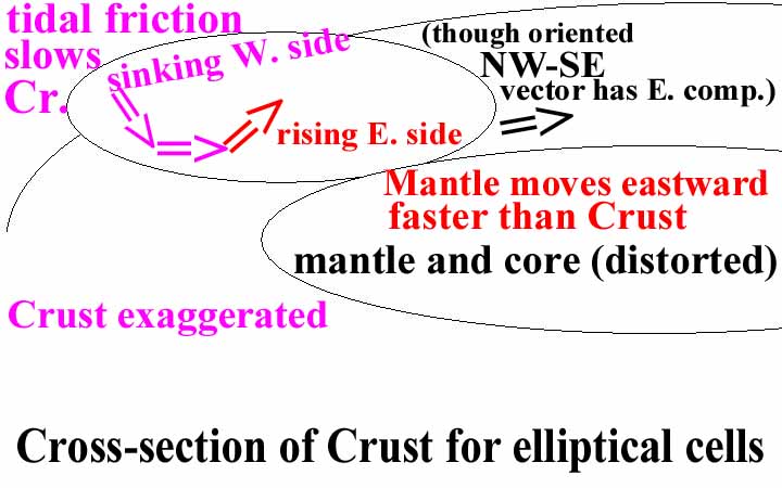
 ABOVE IS A DIAGRAM, ARRANGED BY ME AS AN ORIGINAL- WHICH SHOWS HOW THE FASTER-MOVING MANTLE DRAGS THE CRUST EASTWARD, CREATING SUBDUCTION. THIS IS ONLY ONE OF 4 MECHANICS' ACTIONS, WHICH DETERMINE THE STRUCTURAL ANOMALIES NOTICED IN THE EARTH'S CRUST. LINEAR MOVEMENTS (THRUSTS) CREATE A DYNAMIC WHICH CORIOLIS SENSES AND WITH WHICH ROTATIONS OF THE CRUST ARE INITIATED. ASTEROID STRIKES DISTORT THESE MOVEMENTS, AND CREATE OTHER WOBBLES AND MOVEMENTS OF THE CRUST. THESE ARE LARGE OR INSIGNIFICANT, ACCORDING TO THE SIZE OF THE IMPACT. THE LARGEST I HAVE STUDIED WAS PTr (PERMIAN-TRIASSIC BOUNDARY), THE NEXT WAS KT(CRETACEOUS-TERTIARY BOUNDARY) AND OTHERS WHICH ARE SMALLER BUT SIGNIFICANT OCCURRED AT 41 M.(OE), 28 M.Y.(MIOCENE) AND THE ONE WHICH INITIATED THE ICE AGE AT APPROXIMATELY 2 M.Y. I WILL INCORPORATE THESE ALL- USING FIELD, GOOGLE EARTH, AND DIGITAL PHOTOGRAPHS, PLUS EARTH SATELLITES VIEWS OF ATMOSPHERICS AND OCEAN MOVEMENTS, WHICH ARE DETERMINED BY MOON-CREATED TIDES (EARTH TIDES).
 QUADRANSPHERE(MY WORD)IS AN ELLIPSE WITH GAPS. THE TWO MOST IMORTANT ARE THAT IN THE EASTERN PACIFIC, SOUTH OF HIWAII AND THAT BETWEEN THE PUERTO RICO TRENCH AND THE MAR (MID-ATLANTIC RIDGE):
BELOW IS A MODEL FOR THE CORE-MANTLE INTERFACE, WHERE THE CORE IS HYPOTHESIZED TO ROTATE FASTER THAN THE MANTLE. I DON'T USE THIS MODEL, SINCE I FIND THAT ALL STRUCTURAL CHANGES INVESTIGATED ARE THE RESULT OF CRUSTAL MOVEMENTS (VERSUS THE SLIGHTLY FASTER-MOVING MANTLE). THE GAP SHOWN IN THE ATLANTIC NE OF THE PUERTO RICO TRENCH IS SHOWN, BUT THE GAP SE OF HAWAII IS NOT SHOWN. THIS IS AN IMPORTANT DIFFERENCE, SINCE I FIND NO CRUSTAL ANOMALIES IN THAT REGION. THE NORTH AMERICAN QUADRANSPHERE, Qsna, IS AN ELLIPSE (AS IS SHOWN IN THE MATSUSHIMA (PINE ISLAND) MODEL, BUT IT SO FAR SEEMS TO BE MOTIVATED BY ASTEROID STRIKES AND CORIOLIS ROTATIONS OF THE CRUST:
NOTE: THE FOLLOWING REPORT AND ANALYSIS IS AN ON-GOING INVESTIGATION. YOU WILL FIND MINOR ERRORS (AND SOME MAJOR ONES, SINCE I ORIGINALLY THOUGHT THAT THERE WAS SOME VALUE TO THE PLATE TECTONICS THEORY. I NOW FIND THAT IT IS CORRECT ONLY FOR THE MID-ATLANTIC RIDGE, WHERE MAGNETIC STRIPING AND LATERAL SHEAR OCCUR). THESE ARE GRADUALLY BEING CORRECTED AS I PROCESS MORE CASES PERTAINING TO THE CIRCUIT MADE BY THE ROTATING QUADRANSPHERE. FOR EXAMPLE, IT NOW APPEARS THAT THE REASON THAT ICELAND REMAINS RELATIVELY STATIONARY THROUGHOUT TIME IS THAT THE KT STRIKE IS BEING OFFSET BY A STRIKE OCCURING APPROXIMATELY 41 M.Y. AGO. THIS IS SIGNIFICANT, AND I AM LOOKING AT OTHER FEATURES WHICH BEAR ON THIS MAJOR DEVELOPMENT. CONTINUE!

 ABOVE IS A LOCATION MAP OF THE OLYMPIC MOUNTAINS AND PENINSULA, WA. THIS IS ALSO SHOWN BELOW, IN AN INTERPRETATON OF THE MOVEMENTS WHICH HAVE TRANSPIRED SINCE AN ASTEROID STRIKE OCCURED TO THE EAST IN CANADA, AFTER THE KT STRIKE, AND LIKELY DUE TO THE 41 M.Y. EVENT SHOWN AT THE KIMMEI SEAMOUNT IN THE HI-EMPEROR CHAIN:
  THIS HAS HAPPENED SINCE AN ASTEROID STRIKE OCCURRED TO THE EAST, SHOVING THE CANADIAN REGION TO THE WEST- CAUSING A ROTATION ABOUT THE OLYMPIC MOUNTAINS FULCRUM (WHERE THE TREND IS N-S TO MENDOCINO (THE CASCADES EVENTS), AND MOVING THE ALASKA PANHANDLE PROGRESSIVELY TO THE NW. IN THE PROCESS, THERE WAS NO SUBDUCTION (CREATING VULCANISM) TO THE NORTH- AS THERE WAS TO THE SOUTH. THERE DO OCCUR LARGE SHEAR SLICES, AS IN THE SKAGWAY AREA, WITH THE LYNN CANAL:
THE "BIG PICTURE" IS SHOWN FOR THE WEST COAST FROM WA TO AK:

 NOW FOR THE DETAILS, ANALYZING THE OLYMPIC PENINSUA AND ACTUALLY "DOING FIELD-WORK" NEAR CRESCENT LAKE AND PORT ANGELES:
 ABOVE IS A GOOGLE PHOTO OF THE NW, USA- A PORTION OF WASHINGTON STATE, AND BELOW ARE THE OLYMPICS AND "HORN OF WASHINGTON" ENLARGED:
 THE REGION TO ALASKA FROM WA STATE IS SHOWN FOR THE "BIG PICTURE":
During 2010, I determined that the Olympic Mountains were the focus (a FULCRUM) of several movements in the Pacific NW USA and Canada. This derived from field work, study of coastlines, analysis of Google Earth photos, and interpretations from slickensides which were laterally-striated and found to have directional indications.I USE THE ACRONYM "MAD-MACS" TO INDICATE THE PRINCIPLES OF:
MANTLE DRAG-MOUNTAIN-AUGMENTED CRUSTAL SHOVE DYNAMICS (MECHANICS-PHYSICS); THE MANTLE MOVES THE BASE OF THE CRUST EASTWARD, WHILE TIDAL DRAG SHOVES MOUNTAIN RANGES WESTWARD: THIS HAS HAPPENED SINCE AN ASTEROID STRIKE OCCURRED TO THE EAST, SHOVING THE CANADIAN REGION TO THE WEST- CAUSING A ROTATION ABOUT THE OLYMPIC MOUNTAINS FULCRUM (WHERE THE TREND IS N-S TO MENDOCINO (THE CASCADES EVENTS), AND MOVING THE ALASKA PANHANDLE PROGRESSIVELY TO THE NW. IN THE PROCESS, THERE WAS NO SUBDUCTION (CREATING VULCANISM) TO THE NORTH- AS THERE WAS TO THE SOUTH. THERE DO OCCUR LARGE SHEAR SLICES, AS IN THE SKAGWAY AREA, WITH THE LYNN CANAL:

The Olympic mountains are a parabolic arrangement of Tertiary Crust, which can be used as a test for the general observation that all protrusions above sea level are subject to increased friction and west movement due to the Moon’s tidal drag on the Earth’s surface (relative to lowlands, which are slowed less by friction than are bulges on the earth’s surface). The principal movements were as follows:
1. The Mantle is dragging continental shelves eastward, causing a rotary (VERTICAL) dive under the Crust in a CCW rotation- viewing to the north.
 This is occurring whenever there is no significant offset by westward moving protrusions-such as mountain chains near the coast- and asteroid strikes to create anomalies. An example for this area is the Cascades chain, which is created by the CCW rotation of the crust- diving under the coast and rising east of the mountains. This creates a N-S chain of volcanoes and transforms in the ocean, with mirror image arrangement of rivers on the eastern side of the rotation:
2. Mountains and other protrusions are moved westward by EARTH TIDES, where the higher elevations crust is slowed relatively to lowlands. In the process, the protruding mountains shear against the lowlands to the north or south:


PLEISTOCENE ICE AGE, CONTRAST OF SINKING WITH WEIGHT OF ICE, VS. RISING WITH REBOUND IS SHOWN ON WHIDBEY ISLAND- A TRUE ISLAND WITH COVERING OF TILL AND GLACIAL DEBRIS FROM ONLY 14,000 YEARS AGO (STARTING OVER A QUARTER MILLION YEARS BEFORE THAT):
THE GOOGLE VIEW FROM SPACE SHOWS THAT THERE IS AN INTERMEDIATE ROTATION, BETWEEN THE TWO BLUFFS AT THE CLIFFS BETWEEN THE TWO SINKS AT MUTINY AND USELESS BAYS, WHIDBEY ISLAND; THIS IS NOW CCW, WITH RISING, CONTRASTING TO CW, WITH SINKING DURING THE ICE AGE:

3. The Pleistocene ICE AGE had its own peculiar protrusions, and these caused westward displacements as well as Coriolis rotations about the sheared E-W linears;
THE UTSALADY FAULT SYSTEM OF NORTH WHIDBEY ISLAND SHOWS VARIOUS MOVEMENTS ALONG FAULTS (DUE TO REBOUND AFTER THE ICE AGE AND BEFOREHAND, WITH SINKING DUE TO WEIGHT OF THE 1 KM OF ICE THICKNESS

ENLARGING,


 PHOTO ABOVE SHOWS A THRUST, WHICH HAS BEEN REVERSED DURING THE MELTING OF THE ICE (CW FOR SINKING, CCW FOR RISING WITH REBOUND). THIS IS SHOWN IN LARGE VIEW BELOW, TO SHOW THE SENSITIVITY OF THESE SOFT, LOW VISCOSITY SEDIMENTS- PRESTONE- TO ROTATION, SHEAR, AND LATERAL MOVEMENT OF THE CRUST:
 OTHER VIEWS ARE SHOWN BELOW, WHICH SHOW THE NORMAL BEDDING (ALMOST LEVEL) NEARBY TO THE EAST, OF TILL AND GRAVEL FROM THE MELTING OF THE ICE:

4. Coriolis force is invoked (ABOVE)whenever there is any independent movement, and the direction of rotation is reversed for thickening ice (CW), compared to melting ice (CCW) and expanding-heating regions (salt domes and radioactive hot sources) versus sinking-shrinking basins, depressions, and craters; and,
5. Asteroid strikes, which create craters at the location of impact and antipodes (rises, uplifts or mounds) on the opposite side of the earth.
The PROBABLE EO asteroid strike and its antipode creates a major complication in the NW USA and Vancouver province, Canada. The area north of the USA border and the Darrington-Devil Mountain fault has been dragged in a CW rotation- all the way to the Panhandle of Alaska. This is shown in the following Google photos, found while searching for craters in the Indian Ocean:


Notice that there is a 3250 km diameter depression in the region north of Antarctica,-which has islands near its rim: French Southern and Antarctica Islands. This depression is near 17,000 feet at its center, and it decreases in depth in all directions. This is insufficient to be FAIRLY certain that it is a crater, but the circular sedimentation or siltation pattern is a major indicator. Further, the islands nearby are volcanic (but appear to be of a Late Tertiary age). Transforms in the circle of interest converge on the region, and there is a major scarp south of Australia (sub sea) which indicates a parallel-ness with Antarctica and the region of siltation. The only feature missing of my indicators for asteroid craters is that of fragmentation of islands (which occur in all others studied: East Indies, West Indies and Northern Canada-Hudson Bay), but the feature is so large on a global scale, that Australia and the East Indies could yield the expected fragmentation pattern. My confidence is high for this assessment, particularly when there is a concomitant rise in most of the antipodal province of British Columbia- where there is an obvious rotation. The ANTIPODAL entity should be spiraling CCW if rising, but the age of 41 m.y. has probably abated the expansion, creating sinking from the original uplift. Another feature searched is that of flood basalts- which have been present in the antipodes of KT and EO (B&R to CP). These would be of TEERTIARY age, and I will search the literature.


 NOVA SCOTIA FLOOD BASALTS PORTRAY AN OPENING IN THE TRIASSIC; THIS IS CLOSER THAN OTHERS FOUND, WHICH MAY BE RELATED TO THE PTr ASTEROID STRIKE IN CANADA (IT IS UNKNOWN HOW RAPID THE TRANSMISSION OF A STRIKE SURGE OCCURS, AS IT PROPAGATES THROUGH THE EARTH):
Should the Tonga trench occur as a result of the pear-shaped earth having been created by PTr, the fact that it is shearing at the largest rate measured for the entire earth hints of another complication. The “guts” of the whole matter of asteroids striking and having long-lasting effects is that it is unknown just how a strike propagates through the CORE AND MANTLE of the earth. Is it a mechanical wave, encountering viscosity some 10 billion times that of water, or is it a combination of compression-convection of heat through a somewhat fluid core?
STAY TUNED, AS I FIND SOLUTIONS TO OUTSTANDING INVESTIGATIONS AS I ANALYZE AND MAKE CONCLUSIONS ABOUT EVENTS FOR THE ENTIRE EARTH.
I have worked with features at Hf and nearby, which are of the age of a few million years, but I suspect that erosion, superseding events, and weathering take their toll on the continental crust- such as to “en-faint-ize” the traces. However, under ocean water, this is not a problem; the shear marks (transforms), rifts, and arcuate arrangement of extrusives are well-preserved. Further, I am too familiar with the Puget Sound and its many movements to try to find the original CCW uplift traces of the region. But there is one feature, which allows an assessment- the movement of land mass westward, due to TIDAL SHOVE. This is about 2 km, as shown in Puget Sound, near Whidbey Islands, and I place below a Google Photo of the San Juan Islands (which are post-Mesozoic remnants of westward thrusting, along with the Darrington-Devil Mountain fault):

Notice in the above photo, that the movement or separation of the islands is about 2 km for the locations where there is little complication from Coriolis rotation or other dynamics. This is similar to that found near Whidbey Island, in the Hood Canal spread. This spread occurs with glacial till and other young covering, and I take it that the assessment is approximately correct. However, for the SJ islands, this has happened since the uplift of the Olympics (41 m.y.) and it appears that the separation is similar. This creates a new puzzle, where movement rate is 2 km/41 m.y. = .05 mm/yr. This is unacceptable, comparing all of the data I have accumulated for earth movements- due to EARTH TIDES. This makes it appear that the Olympics did not move SJ islands during the period before the ice age. There is another way of evaluating all this, and that is to view Mt Constitution- the tallest feature in all the islands, as it should move westward faster than any of the other islands. Again, the channel to the east of Orcas- which exhibits the mountain- separates the next eastward island by about the same distance. SJ islands are further from Mt. Olympus than is the Hood Canal, and the only tentative conclusion for the movement rate determination is that the Olympics are of such a small size and height that they indeed affect the movement of SJ only slightly.This presentation is lengthy and I will continually add to it over the next month. I find that each six months I have sufficient new findings to augment the previous reviews, and that I need to re-capitulate in order to update my understanding. STAY TUNED!

BELOW IS A PHOTO, WITH COMMENTS, WHICH IS ONE SCENARIO FOR THE LACK OF SIGNIFICANT MOVEMENT OF THE SAN JUAN ISLANDS, DUE TO THE RISE OF THE OLYMPICS. ASIDE FROM THE FACT THAT SJ IS FAR FROM THE RELATIVELY SMALL MOUNTAIN CHAIN (COMPARED TO VANCOUVER ISLAND), THE ICE AGE HAS CAUSED AN EASTWARD ROTATION OF THE ICE-COVERED EAST SIDE OF THE OLYMPICS- WHICH LATER WAS REVERSED BY REBOUND. THIS LEAVES A NET MOVEMENT OF 2 KM DUE TO VANCOUVER ISLAND MOVING NORTH AND WEST-WARD AWAY FROM PUGET SOUND:

SJ IS A COLECTION OF SEPARATE GEOLOGICAL REGIONS. ALTHOUGH DUE TO THRUSTING AND INTRUSION, THE VERTICAL ARRANGEMENT OF FORMATIONS IS NOT IN THE ORDER EXPECTED FOR A SIMPLE MOVENENT TO THE WEST. SAN JUAN SEGMENT HAS DEVONIAN LIMESTONES (WHICH WERE QUARRIED FOR LIME), AND IT IS RELATIVELY HIGHER IN THE COLUMN THAN CRETACEOUS ON ORCAS AND JURASSIC ON LOPEZ ISLAND. THIS ALL INDICATES THAT REVERSALS AND ROTATIONS OF THE VARIOUS FORMATIONS OCCURRED. NOTE THE INTRUSIONS BELOW:

Let’s review the Olympics rotation, using Google Earth for the “beeg Picture”. Below is a photo of the portion of the Olympics rotation, in which I have some confidence (ignoring rebound, later small asteroid strikes, and minor movements):


I have previously placed all of this in a MODEL, OR DIAGRAM, so that the largest features are presented:


My original is correct for the major features:
1. Subduction is shown as a vertical rotation of the coastal N-S region, with a HIGH ELEVATION OF the Siskiyou Mountains and a LOW at the Columbia River. Essentially, the EO strike has rotated BC CCW-dragging the BOUNDARY OF THE region portraying the Cascade vulcanism eastward (HORIZONTALLY);
2. The Mantle drags the base of the region exhibiting vulcanism to the east. The Sierras move westward since they are not sufficiently deep to encounter the Mantle. Vulcanism ceases at the Canada border, since that is the region rotating horizontally (NOT VERTICALLY, AS WITH THE CASCADES). This adds some credence to the BC rotation- which has to be originally CCW, not that now- which is CW- and exhibited as a left-lateral fault in the north part of Whidbey Island- and where I have measured the movement in concrete slabs);
3. Both the Central valley and Willamette rivers flow away from the divide at the Siskiyou Mountains (tracing E-W), and this occurs because of the plunge of the vertically-rotating cell of Crust in both directions (CENTRAL VALLEY TO SAN FRANCISCO AND WILLAMETTE RIVER). The downward tilting northward from the Siskiyous occurs as a downward reaction to the tilt created by the antipodal rise in BC. Puget Sound represents a transition zone, where there is fragmentation of islands rather than tilt (at the junction of the BC antipode and termination of the Cascade vertical rotation). More work needs to done on the LOWLANDS OF THE PUGET SOUND- THERE IS AN ANOMALOUS SITUATION, MECHANICALLY, FROM THE COLUMBIA RIVER TO THE CANADA BORDER;
4. There is a deepening of the base of the Cascades, as extrusion occurs to the north of the trend. This has several implications:
a. Vulcanism should be younger and have deeper earthquakes to the north. This seems to be true for Mt. St. Helen, Baker, and Rainier, but NOT FOR MT. LASSEN! Lassen is a boundary extrusion, and we will search for other dynamics there- such as that associated with SUTTER BUTTES, RHYOLITES PROGRESSING EASTWARD TO YELLOWSTONE, AND SHEAR AT 40N EB;
b.Mendocino-Cascades border region has irregular movement. This is seen by the path of the Rogue River, which I have found has some underground paths (under lava tubes with saw-tooth shear at the cover, that I have hiked over); and,
c. The Sierras are a shallow crust phenomenon, while subduction, slide over the continental shelf, and Cascade vulcanism are affected by drag by the Mantle (moving eastward, relative to the slower-moving crust); and,
5. The over-all implication is that a major strike- such as EO- affects a large region (the entire west coast of NA, from CA to Vancouver, to the Alaska panhandle. This probably has some influence on Death Valley, DV, but that is on the southern end of the vulcanism-less Sierras and interrupted by another strike at the 28 m.y. age. DV has two major movements: N-S and NW-SE, portrayed by the Armargosa and the Sierras. We will continue the field research there, with another outing at the end of the year. Incidentally, fossil research has produced evidence - presented by scientists from Oregon- that there occurred a 15 F drop after the EO strike (33m.y. reported). I have not investigated temperature-related matters; only MECHANICS movements and change with time underlie all of my work. I do get a hint that the SUN HAS INFLUENCE ON THE TRACE OF LINEAR ISLAND CHAINS IN THE PACIFIC OCEAN- WHICH CROSS THE EQUATOR, AND THEREFORE HAVE NOTHING TO DO WITH CORIOLIS FORCE. I SAVE THIS THERMAL INFLUENCE FOR FUTURE INVESTIGATION, SINCE I WILL INCORPORATE THE EFFECT OF THE EARTH-MOON WOBBLE WITH THE SEASONS, THE YEARLY CHANGE OF SOLAR HEATING FROM NORTH TO SOUTH, AND THE RESULT OF MOON’S ANGLE TO THE ECLIPTIC BEING AT VARIANCE WITH THAT OF THE EARTH (5 VS. 23.5 DEGREES).
BELOW IS A PHOTO, WHICH I WILL INSERT IN THE APPROPRIATE PLACE, AFTER DETERMNING ITS ACCURACY OF PORTRAYAL:

 NOTICE IN THE ABOVE GOOGLE EARTH PHOTO, THAT THE LARGER MOVEMENT DUE TO EARTH TIDES IS WESTWARD (BEACHES ARE CONVEX WESTWARD). HOWEVER, THERE ARE MANY SMALLER AND LATER ARCUATE BEACHES CONVEX EASTWARD; THIS INDICATES THAT ALTHOUGH THE DOMINANT DYNAMIC IS NORMAL (WESTWARD IN THE NORTHERN HEMISPHERE), THERE OCCUR SMALLER EVENTS LATER IN TIME THAN THE INCIPIENCE OF "CHATTER". THERE IS INFORMATION IN THESE ARRANGEMENTS OF BEACHES:
1. THE DIP ANGLE OF WHAT IS CALLED SUBDUCTION BY GEOLOGISTS;
2. THE ANGLE OF ATTACK OF THE METASEDIMENTS TOWARD THE N-S BEACHES;
3. THE DEGREE OF METAMORPHISM; AND
4. THE AGES OF THE BEACHES, AS MEASURED BY THE DIAMETER OF THE ARCUATE PRESENTATION (ORTHOGONAL TO THE BEACH CENTER, AS CALCULATED BY DIAMETER/GRID SPACING OR TIME PER DEVELOPMENT OF INDIVIDUAL GRIDS. I WILL MAKE A TRIP TO THIS OLYMPIC NATIONAL PARK, TO VIEW THE BEACHES FOR PHOTOS AND MEASUREMENTS.
