SUMMARY: Analysis of EVAPORITIC BASINS has yielded new information about the Basin and Range PROGRESSION throughout TIME! This started with the Colorado plateau RISE after 41 m.y. as a POLAR SHIFT and resultant SINKING-EXTENSION of the Wasatch N-S LINEAR. The separation began similar to an ANTICLINE, where the rise is acccompanied by an E-W EXTENSION, instigated by a SPLITTING of the rise and enlargement of the RESULTANT ELLIPSE. First, there occur 2 OPPOSING ARCS ( ), which become POLYGONS with time of EXTENSION, and the number of SIDES INCREASES with GRAVITATIONAL ADJUSTMENT.

This can be viewed on a small scale with the YELLOW KNOLLS POLYGONS- which are 4 sided for a vertical SCARP, and progressively become more-sided as the Hill behind the scarp is surmounted.


This
combination lies on a CRITICAL LATITUDE-LONGITUDE and TIME of formation,
similar to the Caspian at its critical coordinates of 45 degree North (quarter of 180 degrees) and 52 36’E. Longitude
which is a fraction of the 1.6 ratio of the Diomede PRIME NATURAL MERIDIAN, and
TIME (in relation to the BINARY SUCCESSION). Pyramid Lake’s Northern portion
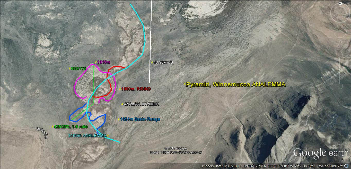
exists at CRITICAL FRACTIONS of 40.1N 119 40'W- 50E of Prime.

After using the more correct 169 40'W Greenwich-referenced Meridian and finding that some anomalies were closer to 170W (which is less cumbersome for memorization), I switched to the more simple 170W- even though it slices a part of Siberia, and is probably has a slight error.


Comparing Pyramid Lake Meridians to the Caspian Sea:

The LARGEST AGE CALCULATION is near 1.5 m.y. This must be distinguished from LIKELY CRITICAL TIMES of 2.048 m.y. (ELTANIN) or 1.024 m.y.- a quarter of the PREVIOUS INSTABILITY of 4 m.y. (4.096?).


Pyramid lake lies on CRITICAL COORDINATES; how about the CRITICAL TIME?


The greatest CONTINUOUS ARC AGE is near 1.5 m.y., for the SOUTH PART OF THE LAKE; now the DIVIDER ANGULAR SHIFT must be found, so that the angular RATE can be calculated:

Geologists have determined NEARBY LAKES have formed GRABENS-EXTENSIONS over the 4-10 m.y. periods. It is more likely that the 2 m.y. AGE is correct, but we will have to determine this independantly!

It is nearer 1.024 m.y. and this is a QUARTER of the more DISTANT 4 m.y. ANOMALY! This is for a CRUSTAL BLOCK NOT in the Pyramid :Lake. We'll search further to the east: the Winnemucca DRY LAKE LOXODROME:
Above is a MAGNIFIED VIEW, and below is a SEPARATE ARCUATE PLAYA. This is part of a N-S array of 5 playas, and shows that they PROCEEDED SOUTHWARD (CW-SINKING):


ABOVE MOUND is domal, with an ARCUATE CENTERLINE. THIS IS TYPICAL of all features investigated so far. Notice the CENTER SLICE in the Zion Watchman Trail knob, where the rock has fallen from its FULCRUM high above the trail:

A CENTERLINE between 2 arcs is shown for a HAND SAMPLE (CENTER SLICE forms the center of the FIGURE 8 or ANALEMMA):

Although the DOME is from a previous time when waterlevels were higher (ice age), it has formed from ANOMALOUS GEOCHEMICAL SOLUBILITY CHANGES:

The WINNEMUCCA DRY LAKE (arroyo) is 89 km in N-S LENGTH, which is a LOXODROME (Meridian) and EXTENDING throughout TIME in both W-E and N-S DIRECTIONS. It is 100 x the N-S EXTENSION of Ala Spit RISE, but it is a SINK! This is another curious development of GRAVITATIONAL LATERAL MOVEMENT, and one which relates that both SINKS and RISES follow SIMILAR RULES!
This is a valuable FINDING- one which yields MEANS for checking EARTH TIDAL RATES- ROTATION RATES, and ORTHOGONAL RATIOS (5 to 1 and 16 to one for this case, considering the number of ARCUATE PLAYAS and CIRCULAR BARS for Ala Spit, and orthogonal DISTANCES for the north ARCUATE PLAYA)! For the 5 ARCS, there are 16/5= 3.2 ratios, and pertinent to Saturn with ratio of 3.125, or 1.25 x 2.5 for Jupiter. I'l check this further:

Ala Spit RISE at Whidbey Island, WA, has another LOXODROME, but this relates to a RISE, and the RATIO of N-S LENGTHS is 100:1 (89 km vs 880 meters, for Ala Spit):

I hiked this beach several times, noting that the north shore was a CONTINUOUSLY-DECREASING DISTANCE from the center of ROTATION! It is a SPIRAL, but one which ABRUPTLY SHIFTS to the further south ARC. These make partial figures 8, with the eastern portion eliminated!


Since the CENTERLINE DIVIDER is an anomalous RISE, between two SINKS, it is a "TIT" which has risen GRAVITATIONALLY subsequent to the LAKE EXTENSION to the east; its AGE must now be determined, to find the INTERMEDIATE TIME NTERVAL:

Determining the OLDEST RISE:

ALL INDICTIONS are that the RISE STARTED just after the LARGER Pyramid-Winnemucca EXTENSION to the east- which CREATED 2 SEPARATE LAKES- deep to the west, and SHALLOW to the east. This all is related to the 1 m.y. CRITICAL TIME, forming an ANOMALY at the CRITICAL COORDINATES! My analysis is that a SIMILAR SITUATION occurred at the CASPIAN SEA- forming a shallower Karabogas SALT PAN, EAST of the DEEP Caspian. VERTICAL ROTATION is CCW for the Pyramid- descending to the west and rising to the east (viewing from the south). Vertical rotations are always COUNTER-DIRECTION to those above, e.g. for SCARPS GREATER THAN 45 degrees, the vertical must mesh with the horizontal- CCW underneath CW (EARTH below a SINK is ROTATING OPPOSITELY, like GEARS MESHING- one is rotating CW and the other CCW, at RIGHT ANGLES to each other, as is the crust below an outcrop)!
Another LOXODROME lies to the west in the STRAIT of Juan de Fuca- Protection Island; this is shown for COMPARISON (NOTE THAT THERE OCCUR ONLY 3 ARCS-RISES:

"Homing in" on the N-S portion:

This lies near 48 10N 123W, but does not "fit" the GLOBAL MERIDIANS; these are RARE, so will not require much work to find their DERIVATION. There are many VARIATIONS in Puget Sound- there being shallow DEPTHS and CLEAR VIEWS!
Lakes to the NW of Pyramid are OLDER (although SMALLER) due to having been formed further to the WEST, BEFORE EXTENSION of the Basin to the EAST, 20 km each 1 m.y. TUFA formed when the EXOTIC WATER LEACHED solubles from the CaCO3 EVAPORITES:


The CRITICAL COORDINATES are different than EXPECTED FRACTIONS (slightly, less than 1%), but this may be IMPORTANT as far as ANOMALY VIOLENCE or EARTH INSTABILITY is concerned! I'll find a case where this is DEMONSTRATED, MATHEMATICALLY! The EQUATION to satisfy is:
I= (360- A)/A = I; 4A= 360 for I= 3, a NORMAL RECTANGULAR SCARP.
We will find the POLYGONAL CASE, where I is unknown (I= 7 for an OCTAGON).
CRATER LAKE, with associated WIZARD ISLAND, at 1/6th of E-W DIAMETER; I= 11, with 30 degrees SPACING (12 subdivisions):

I'll categorize several cases, so that the COMMONALITY may be determined!
Honey Lake, Milford, CA:

This case is ELLIPTICAL, with the NW RISING and the SE SINKING:

The OLDEST PLAYA-SALT LAKE is probably the GREAT SALT LAKE, UT; I'll find whether it fits the CRITICAL COORDINATES of 40N and 110W- 60 east of the NATURAL PRIME MRIDIAN:

The greater region of GSL is so large, proceeding to EXPAND since INCEPTION, that it should yield clues as to what came first. It is certain that the ENTIRE FEATURE HAS MOVED WESTWARDLY- creating the separation of the Sierras and the Wasatch Mountains. Geologists have NOT been able to find the lost portion, because it has extended-subdivided into many ranges.

The GREATER LAKE is GENERALLY ARCUATE to the SW- informing me that SW is the MOVEMENT DIRECTION. This is the LUNAR INFLUENCE, overwhelming the SOLAR eastward 10.24 mm/year LONG TERM SOLAR EARTH TIDES. The lake is pulling away from the WASATCH RANGE, and the FULCRUM is to the east:

The Uinta Mountains have Pc outcrops, but that is NOT the AGE of the 41 m.y. POLAR SHIFT of 3.6d (1/100th of 360d circle, or 40,000 km). This will have to be CALCULATED from the ARCS shown for the E-W TRAVERSE of the ANOMALOUS Uintas. The first clue is the rare ORIENTATION- which indicates the start of the TRAVERSE, and we already know that the EXTRUSION TRAVERSE started in the Taos, NM Llano Quimado volcanic outpouring at 41 m.y.:

Viewing the Uinta E-W trendng mountains:

The AGE of the rocks is as old as Pc- but the UPLIFT is much younger; the oldest rise may be calculated from ARCUATE or POLYGONAL MEASUREMENTS. A POLYGON yields 1/2 of that from the ARCUATE TIME INTERVAL. Keep in mind that this calculates TIME INTERVAL- NOT NECESSARILY the AGE of the UPLIFT INITIATION!

Below is the LARGER REGION, where the CRITICAL COORDINATES may be found:

The BINARY THEOREM is still working! The SOUTH MOVEMENT is twice as old as that proceeding SW-ward, and 4 x that going westward NOW! The RANGE has proceeded to SPIRAL CW, SINCE UPLIFT INCEPTION- showing that it is ERODING as the CW BASIN and Range EXTENDS-SINKS! This will have to be checked by other means, since this is UNEXPECTED. I anticipated that the range was still uplifting CCW, but this ANOMALOUS BEHAVIOR (similar to the Caspian Sea) is REVERSE at the CRITICAL COORDINATES!

PARALLEL LINEARS in the basin indicate that NOT ONLY is the SHEAR-ROTATION effected by LATERAL GRAVITATION, but that the Mars and Venus RATIOS are dominating (1.6 and 2.0).

Notice the UNDULATING RIVER VALLEY- where the PERIOD is near 2 m.y. My findings are that the 1 and 4 m.y. EARTH INSTABILITIES are much more VIOLENT than the 2, 8, 32 m.y. EVENTS! Eltanin is in the BENIGN CATEGORY, but it is correlated with the ICE AGE, and we have yet to find the reason, except for the MILANKOVITCH ELLIPTICALS of 100 k.y. An ASTEROID STRIKE might have been the TRIGGER, but no doubt that the EARTH-SUN SPACING was LENGTHENED, starting at 2 m.y. (2.048?):

The CRITICAL COORDINATES lie on the south border of the Uinta Basin! This fits with the finding that OIL is associated with a SINKING BASIN (check Anadarko in Oklahoma), and that it continues to PERCOLATE when the FRACTURES are still OPENING. This is further suggested by TEMPERATURE INCREASES in some portion of the basin (where the fluid emerges- bringing HEAT). An interesting study will be the San Juan basin, where the fluids renew as they are PRODUCED xfrom the FORMATIONS-STRATA.

Here are the PROGRESSIONS, so far:
1. After the Chixculub EVENT OF 64 m.y., the INTERIOR CONTINENT began to rise, producing land-locked lakes in the Paleocene-Eocene (until 41 m.y. Taos, NM EXTRUSIONS);
2. The Wasatch Range bi-furcated at about the same time, and the Sierras moved WESTWARD (later than 50 m.y.);
3. Ranges rose N-S in the space between the Sierras and the Wasatch, 1 m.y. apart, creating valleys which extended W-E to 40 km in 2 m.y. and,
4. "RIP" at the north ends of the 13 valleys created RHYOLITIC EXTRUSIONS (not deep enough to reach the BASALTIC MANTLE), starting at 14 m.y. until now (Yellowstone).

Above RHYOLITIC PROGRESSION would appear to be CYCLICAL, with an APPROXIMATE 25 m.y. CYCLE. Ill have to find an independant measurement!

The 41 m.y. EVENT is the 400 km lateral shift of the POLES; this is 1/100th of 360 degrees: 3.6 degrees and 1/100th of the EARTH CIRCUMFERENCE of 40,000 km. It is shown by the GAKKEL SHIFT from the previous LOMONOTOV RIDGE. This will have to be CONFIRMED ELSEWHERE, and I have hints from the BLACK SEA, that it has occurred 3 times in the last 123 m.y. I suspect that the more correct TIME is 3 x 40.96, since the BINARY THEOREM has proven to be very PREDICTIVE, or prescient, so far!

Above GOOGLE EARTH VIEW of the Virgin ANTICLINE exhibits PARALLEL RIDGES-VALLEYS which is a SMALL SCALE of the Sierras-Wasatch SPLITTING-WIDENING-EXTENSION and PARALLEL RANGE FORMATION through time. This feature is 2-4 m.y. in CURRENT OCCURRENCE, compared to the MAXIMUM 41 m.y. (10 x) TIME INTERVAL of the NV-UT basin development! Notice that the SPEAR (NARROWING ANGLE) indicates the DIRECTION of MOVEMENT- NE. This also occurs at outcrops, where the narrow TERRACE POINTS in the DIRECTION OF MOVEMENT (CCW for RISES).

Above is exhibited a "TONGUE" ot TIT, which conventional geology would classify as an EROSIONAL FEATURE, but it is the beginning of ANOTHER SINK WITHIN a RISE! These are REPETITIVE FEATURES WITH TIME, and may be seen on WEATHER MAPS (ATMOSPHERIC TIDES) as a HI PRESSURE WEDGE penetrating a LO Rising bad weather CIRCULATION.

Sand Mountain-Hollow is a SERIES of "STACKED" ELLIPSES, and is composed of INCREASINGLY YOUNG ELEVATIONS as they become smaller. It required 7 years for this to become APPARENT, so the RULES are becoming MORE ACCURATE with INVESTMENT TIME!


Sand Mountain in relation to the VIRGIN ANTICLINE is shown below:

You can see the NARROWING ANTICLINAL VALLEY-RIDGES above. The ANTICLINE makes a 45 degree turn to the left (NORTH) at Virgin River-Hurricane Golf Course- FORMING A PORTION of an OCTAGON! This is a FUNDAMENTAL DYNAMIC of GRAVITATIONAL LATERAL MOVEMENT, and I have been using it without REALIZATION, whenever I used google earth MEASUREMENT TOOL- clicking on SIGNIFICANT INFLECTIONS thinking that I was forming an ARC This does NOT NEGATE PREVIOUS WORK, but CLARIFIES IT
I have found areas in UT, where the 12,900 year event left its arcuate trace, and this leads me to believe that the event occurred in ice-free areas. However, the crust would have shifted for the entire globe as the continental mass decreased. Again, this would have nothing to do with asteroid strikes, but small strikes might accentuate or trigger the changes.


This will be put on hold, since I am now on Whidbey Island, where YOUNG MOVEMENTS (less than 25,000 years) EXHIBIT INPUT for recent events. STAY TUNED!