1. Sand Mountain half meter diameter sink hole introduces this topic:

NEXT LARGER HOLE was photographed in Zion East POOLS TRAIL. Notice the SLICE through the MIDDLE, and the WIDENING of the FRACTURE to the south (OLDER, RIP is to the north):

A small ANOMALY, connected with the New Madrid QUAKE of December 1811 to 1812 is that of Big Lake, AR- my Dad's FARM, where there occur many INDICATIONS of the DISRUPTION which created the GRABEN and caused the Mississippi River to REVERSE COURSE, TEMPORARILY:

2. Sedona SINK HOLE (increasing in SIZE as we PROCEED):


3. Dugualla, Whidbey Island, WA Pond and rise to the south:


Although the pond is 100 years (by Man's damming the valley), the RISE near the springs is ancient:


OBLIQUE:


CENTER LINE (FAULT) at I-15 freeway Feeder, above, is shown in DETAIL, BELOW:

This YOUNGER SLICE traces through the middle of the HOLE, creating SLICKENSIDES, BELOW:


6. Lake Okeechobee, FL is a SINK within a Peninsula (the Florida "TIT"), which is developing ELLIPTICITY:

NOTICE that the LAKE is ELLIPTICAL- forming an ANALEMMA, half figure 8:


7. Death Valley National Park, CA exhibits a below-sea level SINK:

SINK is becoming ELLIPTICAL with TIME:

All of the above are seen as having the following characteristics in common:
A. They are ROUND- developing ELLIPTICAL shapes with TIME; there is a RISE to the RIGHT (CCW of ss. on right side), and a SINK to the left (CW), so that the SLICE APPEARS as a LATERAL THRUST on the LOWER ELEVATION SIDE:

Jurassic Navajo sandstone OUTCROP introduces a SLICE which proceeds from an INDENTATION- the start of the HOLE. This is ORIENTED with north to the LEFT, and the slice is seen as a FAINT FRACTURE:

B. They result from a SLICE through the middle- oriented N-S- and the WIDER PORTION indicates the OLDER part. The MOVEMENT is to the south on the right side (scarp moving Counterclockwise, CCW), and to the north on the left (lower elevation, relative to the outer right side, moving CW outside the HOLE);
C. The hole becomes wider and DEEPER with TIME; and,
D. Each is a FOCUS of ROTATION of the Block of CRUST which surrounds it.
The FOLLOWING LARGER, OLDER HOLES may depart from the above characteristics, but the SCALE and AGE is so large as to become UNIDENTIFIABLE:
8. Dead Sea, Israel to Jordan- the DEEPEST SINK in continental land mass:


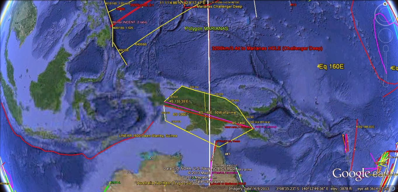
9. Challenger DEEP, Marianas Islands,south of Guam- the DEEPEST HOLE in the entire Globe (10,000 meters);

The DEEP BASIN does NOT allow location of the N-S SLICE, and indirect measurements must be made:
The OLDEST hole investigated is Hudson Bay, where James Bay is the N-S SLICE:

Hudson Bay lies at SEA LEVEL, and cannot be DISRUPTED by rises offsetting the NORMAL EARTH TIDES! The CALCULATED AGE seems small, nevertheless. It is surrounded by the CANADIAN CRATON- which is Precambrian, and the HINT is that the 41 m.y. (40.96 by BINARY THEOREM) event has modified the TIDAL RATE! I'll keep this disruption in the background.

SOUTHERN HUDSON Bay:

Hudson Bay, WEST:

Added INFORMATION is exhibited by the YOUNGER ARCS-SLICES:


Ulithi ATOLL I have visited (I met the King- who was noted by the LARGEST ARRAY of Tattoos), and it is near the TRENCH ARRAYS:

Below is the RISING ARRAY of Islands and SEA FLOOR, which accompanies the LINEAR SLICE to the North:

Below Island and ATOLLS have the USUAL ANALEMMA (half Figure 8) CONFIGURATION:

10. Yellowstone NP,WY- an ACTIVE GEOTHERMAL site, which is a hole within a MOUNTAIN UPLIFT.


Miscellaneous ENTITIES include:
a. Holes within POLYGONS (example between the red and blue lines):

b. Lake Stoneman, AZ Collapse feature, within the Mogollon Rim and associated EXTRUSIONS (AGE near 60,000 years- similar to the Williams, AZ Meteor Crater);
.jpg)
c. Mesquite SINK HOLE, AZ, also beside a LARGE SCARP,

d. The BLACK SEA- which is now an OBVIOUS ELLIPSE, with the N-S centerline at the INFLECTION of the Figure 8:

Lake Malawi to Victoria- SOUTH of the Equator:
An OBVIOUS CASE of INDENT, SLICE, and Expand occurs in Africa- in the GREAT RIFT Valley. This exhibit shows that, not only does this UNIVERSAL PHENOMENON present the same occurrence as with Hudson Bay (which has SALT WATER) but that it persists in the SOUTHERN HEMISPHERE, in FRESH WATER- exemplifying that the Venus INCLINATION Angle of 3.34 degrees (x 111.111km/degree= 377.53 km) has created it!

The SLICE is 12 degrees from N-S; this ROTATION will be explored:

A more COMPLEX CASE is that of the Beaufort Sea in the ARCTIC. This occurrence is in the Latitudes where the ICE has obscured photography, and where a REVERSAL of movement- to the south, rather than to the west- transpires. Additionally, it may NOT EXHIBIT completely the influence of the Moon in these latitudes above the Arctic Circle:
Arctic Chukchi:

A wider view:

Beaufort Sea- HALF of a circle:

Finally, there is a SLICE in the ARCUATE Beaufort Sea:

Above DEPICTION allows an UNDERSTANDING of the MOVEMENT of the Qsna through the ARCTIC:

The EQUATION (360- X)/X has proven useful for Mars, and using the RATIO 11.862= Jupiter ORBITAL TIME/Earth years, it may be solved to yield 27.9894262 degrees, = 141.67724 degrees East of the NATURAL PRIME MERIDIAN at Diomede (168 40'W longitude). Plotting its equivalent: 141 40'38.064"W longitude, the N-S LINE may be used to determine whether ANOMALIES are related to this feature:

Above Beaufort Sea and Chukchi RISE are indicative of a PARTIALLY-FORMED ellipse and "TIT" moving to the south (opening is wider to the north)! This is REVERSE to that in LOWER LATITUDES! Beaufort must be rotating CCW- which is reverse also; this indicates that the POLAR MOVEMENTS are NOT that of the Latitudes less than 75N

Mendocino TRANSFORM is presented for REFERENCE:
CONTINUING to the HI-Emperor chain:
Although there is NEGATIVE INFORMATION, the below GOOGLE EARTH photo shows that TRANSFORM LOCATION is related to the DEEP PACIFIC HOLE!
The ONLY ANOMALY of any significance is that at the Beaufort Sea- where the Jupiter N-S line splits the HALF ELLIPSE. The line lies west of Mt. St. Elias, which is the ACTIVE GLACIER and prominent mountain along the PATH of the NORTHWARD MOVING Alaskan line of volcanoes:

It may be that the 1.305 degree Inclination from the Ecliptic Plane and its associated 145km linear distance has IMPETUS in this ARCTIC region, where NO other Planetary Mass is involved in EARTH TIDES above the 64N Latitude.
RE-WORKING this N-S LINE, for more ACCURACY, the LINE occur WEST of Mt. St. Elias:

Jupiter has more than 60 MOONS, and this may account for the LACK of GRAVITATIONAL ANOMALIES on Earth- where NO OTHER ANOMALIES are found along the N-S 13919'3.612"W Longitude Meridian!


How can Jupiter GRAVITATIONALLY FORM the SPLIT ELLIPSE at the Beaufort Sea? The PLANET barely departs from the ECLIPTIC PLANE (Inclination of 1.305 degrees, or 145 km PROJECTED onto Earth). It shows its colors with its 145km LINEAR in the Arctic, so manages to PROJECT ORTHOGONALLY (at 90 degrees from a VERTICAL LINE of SIGHT)! This is not over the horizon, but PERIPHERAL to its POSITION over the MID LATITUDES blow the ARCTIC CIRCLE.
This represents INFORMATION NOT INCORPORATED in the TOTAL INCLINATION ANGLES (above the Ecliptic Plane) for the MAJOR PLANETS, and suggests a CLUE as to how the ARCUATE FEATURES move oppositely in the ARCTIC OCEAN (away from the POLE westward). Mars N-S line indicated ANOMALIES within this Arctic Circle also:


This represents a true "HOLE" in the BINARY THEOREM, and I will ferret out the IMPLICATIONS!

The CHECK is in the MAIL-EVOLENT way the HOLE of the Arctic is presented:

Moon is the DOMINANT influence on Atmospheric, Earth, and Oceanic TIDES.
Viewing the Sand Mountain- Sand Hollow FEATURE from Washington City, UT, there is a TILT of 5 degrees/NW (down to the NW- SCROLL 5 photos down):

NOTICE that there OCCURS the LARGEST 'hole" found, and that the SHEAR LINE traces N-S to the POLE of the Moon! The geology culture might explain this as an EXTENSION created by an IMPACT, but the clincher is that there are two CRATERS shown and BOTH shear to the NORTH! You may see these if you EXPAND the photo, or if you obtain a NASA enlargement.
Below is a PARTIAL PATH of the Moon- which is a portion of an ANALEMMA; the light of the Moon is so DIM, that a MEASUREABLE FIGURE 8 is not found:

Earth from the Moon yields a PARTIAL ECLIPSE of Earth:

NOTICE the SHEAR CIRCLES above- same as on Earth! This case has NO GAP, as generally exists on Earth. The LINES SHOWN are due to the photography PROCESS, and they have been removed- 1 frame down- to view the SURFACE UNIMPAIRED:

Sand Mt curvilinear:

TILT is estimated below:

Looking EASTWARD:

MAGNIFYING:

Larger VIEW to St. George, UT:

Considering that this REGIONAL ELLIPSE is lifted by GRAVITATIONAL force, the QUESTION should be asked: "Why is the tilt NOT in agreement with the fact that most Solar system MASSES occur along the Ecliptic Plane- which is closer to our Equator (to the south)?"
Sand Hollow from Sullivan Knoll:

DATA from Wikipedia allows a SOLUTION to this question:
1. Moon's Inclination to the Ecliptic Plane= 5.145 degrees- the TILT;
2. The ORIENTATION of the Moon's ORBITAL Plane is down to the NW;
3. The average SEPARATION from Earth's Center is 385,000 km, yielding a circumference of 2.419 x 10exp6 km (x 10exp9 meters), and 6623 km/day (apprx. 2 thirds of 10,000km, 76.657 m/sec, IF circular).
4. Velocity is 1,023 m/second, NEAR 1000x the 1.024 Binary BASE; and
5. OBLIQUITY is 6.58 degrees, Node PRECESSION = 18.5996 years, with a 27.32 days SIDERIAL CYCLE.

Above is the Moon TILT to the NW of Earth, and below is the DIAGRAM of the PLANES:

There is an ERROR in the ORIENTATION of Earth, referenced to the PLANETS; IGNORE, and notice that the Planet Pluto exerts an ATTRACTION for the TOP-MOST portion of Earth:

Sand Mountain is MAINLY UPLIFTED by the Moon, but other Solar Masses contribute at least HALF AGAIN as much. This is OFFSET by EROSION, and the NET RISE is at least 1 mm/year x .5 m.y.= 500 meters! Since the AVERAGE UPLIFT is near 1500m, the estimated UPLIFT RATE= 3mm/year. This could be made more PRECISE, by finding the (maximum- minimum)/2, or by CONTOURING ELEVATIONS.
Solar System INCLINATIONS, MASS, and IMPORTANCE of (I/d squared) x MASS:
Body Perihelion P squared, Incline MASS ratio; (I/P sq.) x Mass
Moon: 384,400 km; .147763; 5.145d; .0123E; M(I/Psq)= .4283= 1/2.335. Equation (360-x)/x= .4283 yields 252.048, which is 82.448W Latitude (from Prime NATURAL Meridian).
251.483754 degrees yields 81.883754, or 88d 53'1.51",max.
Merc:69.8 x10exp6; 6416, 7.01d, .055 x E= .00006= 1/16641
V: 107.5 million km: 1,772; 3.39d; .815; .001559= 1/641.5
E: 149.6 (subtract V to find CLOSET SEPARATION); mass = 1
Mars: 249.2; 9,920; 1.852; .10744 x E; .00002= 1/49,909
Jup: 778.4; 395,389; 1.305d; 317.82x; .001049= 1/953.3
Sat: 1,349.5; 1,439,681; 2.494d; 95.16x; . 000165= 1/6076
Uran: 2871; 7,405,855; .77d; 14.371x; .00000149=1/669264
Pluto; 7377; 52,599,002; 17.14; .0022x; 1.39x 10exp-9, INSIG
Ceres: 2.767AU; 264,343,200; 10.58d; .00016x; 2.64 x 10exp8, insignificant!
Above MASSES show the IMPORTANCE with the SMALL ratio (Moon Solar System INCLINATIONS, MASS, and IMPORTANCE of (I/d squared) x MASS:
OUTSIDE Uranus, Masses are INSIGNIFICANT, except RETROGRADE-
The FEATURE of importance in the ARCTIC is the RECURRENCE of MOON TIDES, where all others (except the SUN) inflict NO Inclinational SHIFTS! It appears that the REVERSAL of movements- SOUTH, rather than north or west, OCCURS in the ARCTIC (a DUPLICATION of LATERAL GRAVITATIONAL movements! North of the ARCTIC CIRCLE at 66 24'North Latitude, there appears to be a SEPARATE REGIME- where the Moon controls the 41 m.y. 3.6 degree SHIFT, rather than Venus! This RATIO: 5.145/3.6= 1.429, creates a NEW MOON LINE! (360-x)/x yields 251.924 degrees, where 169.6- 251.9= 82.324W Longitude.

Although the DIAGONAL LINES are suspect (possibly part of the SOUNDING or photography), the ANALEMMA is NATURAL:

This is all related to the MARS LINE below:

The DILEMMA is that the ANOMALY ABOVE is duplicated at CABO ST. LUCAS at the Tropic of CANCER:
SUMMARY:
Lateral Gravitational ROTATION and SHEAR creates Holes (Depressions and Basins) in the Earth’s Crust, with IDENTIFYING slices through the centers- which point to the direction of the TEAR, This is N-S in the Northern Hemisphere, with Counterclockwise, CCW, movement on the east (RISING) side. When there is an ELEVATION DIFFERENCE, there is a RIP vertically. These CIRCULAR FEATURES become ELLIPTICAL with TIME, and occur on at least 10 SCALES; the ratio shown for the smallest, compared to Hudson Bay is 800km/.5m= 1.6 million.
Other FEATURES are REPLICATED on SIMILAR SCALES: MOUNDS (the inverse of holes) and “Tic Marks”, which are shown below:
Tics, Monzonite outcrop

The SMALLEST in the Pine Valley Laccolith OUTCROP, compared to those in the South Pacific Ocean have a MEASUREMENT RATIO= 6 km/3 cm= 200,000.
Pacific south Tics trace:

This tells me that I have NOT FOUND the LARGEST SEPARATION of TICS in the deep Pacific, or that there are smaller EXHIBITS in the Monzonite or other OUTCROP! BELOW is an expanded view:

Other Monzonite "TICS" occur at ANGLES to the first N-S occurrence (nearby):

Hiking Pole yields a SCALE: half inch (1.25 cm), and the more precise RATIO is 6km/1.25cm= 480,000! Most LIKELY, the deepest Pacific HOLE has NOT BEEN FOUND YET!
MOUNDS:

MORE DISTANT:

SMALLEST MOUNDS found were near my WA, Whidbey home:

Golf courses yield the best ANALEMMA photos, since the grass is mowed, and the CONTRAST is unmistakable:

The North American Quadransphere can be viewed as a landmass, with inflections at important ANOMALOUS STRUCTURAL DEVIATIONS (angular turns at coastlines). This is shown below, with the 12+ 1777 km SEGMENTS shown in detail:

Introduction to the North American Quadransphere, Qsna www.quadransphere.blogspot.com
Qsna is shown on Google Earth as an ELLIPSE, extending from the Hawaiian-Emperor SEA MOUNT chain E-W to the Mid Atlantic Ridge, MAR, a distance of 10,240 km (base of the BINARY THEOREM, 10,000 x 1.024- a quarter of the circumference of the Globe), and N-S from Central America to the NW Passage. It is divided by the Wasatch Line- a N-S FEATURE which separates the younger Basin and Range from the elliptical Colorado Plateau, CP and the E-W Equatorial BULGE, approximately at 40N latitude. The Continental land mass is divided by a 2048 km distance (from Mendocino, CA) a feature in KS, and a second one at the New Madrid QUAKE SINK at the Mississippi River, 90W longitude- 1024 km east of the western rise.
EXTRAPOLATING, the Pacific Ocean is the LARGEST BASIN, so should exhibit a HOLE the size of Australia- which is the NORTHWARD-MOVING MOUND (continent) with a SLICE created by the Tonga TRENCH and some feature to the west:

Above SINK is NOT the size of Australia, but is a START to finding the appropriate one. The diameter should be on the order of 4096 km:

The ENTIRE NORTH PACIFIC is shown above, with the CENTRAL PACIFIC ENLARGED below:

EXPANDING:


BINGO! The SINK with a Radius of 2700 km, is SHOWN BELOW. This is sufficiently near the 4096km Australia ORB DIAMETER, to allow its USAGE:

ALL of this is HIGHLY SUBJECTIVE for the Pacific Basin, because it uses SEAMOUNTS- which are SEPARATE ENTITIES, and NOT CONNECTED! Nevertheless, this a START to finding the MOUND-SLICE-ROUND SINK, for the NORTHWARD-MOVING Australian CONTINENT, CREATING the Tonga TRENCH, SHALLOW SEA FLOOR to the north, and the ASSOCIATED "HOLE" to the north (which is sliced by the line of SEAMOUNTS)!

NOTE about the difference between a TEAR and a "RIP":
Visualize a piece of CLOTH, lying on a FLAT SURFACE, which is being worked by a seamstress. Holding the cloth with both hands pressed downwardly, while she moves both hands AWAY from each other, the cloth will TEAR (pronounced "tare")- the left piece moving CW, or clockwise, while the right portion will rotate CCW- with NO change in ELEVATION. This is the CASE of the New Madrid EARTHQUAKE ZONE, which was instigated at my Big Lake, AR farm during December 1811 (terminating to the NNE at its most violent occurrence at the Mississippi River). The movement was to the north in 3 great quakes, although the GREATEST EXPANSION has occurred at the south end! As well as can be found from old newspaper REPORTS, the smallest tremor occurred in the Big Lake GRABEN.


Now the seamstress holds the left side down- with a thumb and index finger- and lifts the right side upwardly. This results in a "RIP" at RIGHT ANGLES (orthogonally) to the tear! This is the CASE of the Alaska PANHANDLE, where the Lynn Canal is the tear- proceeding to expand on the south end, while proceeding northward with the tear FAULT. The uplift (RIP) is on the right (East), and the SINK (Gulf) is to the west. TEARS and RIPS occur at RIGHT ANGLES to each other, while the FAULT ZONE may exhibit similar LINEAR DISTANCES!

Above, the DIAMETERS have a RATIO of 1.25, and this does NOT FIT with the RETROGRADE Venus or Uranus! Some OTHER ENTITY is at work here, and I suspect the MOON- which usually exhibits the 1.5 RATIO! Notice that I have used CLUES from boundaries of LAKES and RIVERS to determine the PATH of the ancient dim path (which is preserved, but requires GUIDES to determine!
The BINARY THEOREM relies on NUMBERS and mathematics, rather than classifications, for MEASUREMENT and PREDICTIONS of the Dynamics of the Earth's Crust!
The BASE of the theorem is the NUMBER 2- which is the ratio of TIDAL effects of the Moon, compared to the rest of the SOLAR SYSTEM. All of the usage of the equations and math exhibit SMALL ERRORS, but the relations are easily remembered and yield a SYSTEM of easily tested arrangements!
There are HARMONICS included, so that at least ten sets of associated numbers are REFERENCED: 2; 4: Byam Martin 4 million year AGE; 8; 16: AGE of Columbia flood basalts- 16 m.y.; 32, 64: KT event (Cretaceous Tertiary boundary Chicxulub event); 128; 256: PTr (Permian-Triassic extinction in m.y.); 512 m.y. age of Burgess Shale; 1024 m.y. age of the grand Canyon Great UNCONFORMITY; 2048; and 4096 m.y. age of the INSTIGATION of the sequence.
The first harmonic= 1/10th of the original: .2, .4, on to 819.2 and higher numbers- not yet used, but expected to yield the uplift rate (due to attraction of Earth Crust when the Solar MASSES orbit at an INCLINATION ANGLE away from the Ecliptic Plane) yielding .2 to .4 mm/year RISE. Second harmonic= 1/100th: .02, .04, on to 1.28 and 10.24- the TIDAL RATE of the Solar System, excepting the Moon, which is 20.48 mm/year. Continuing, on to 40.96, yields Milankovotch's AXIAL WOBBLE cycle in kiloyears, k.y. and the Polar TILT ANGLE shift at 40.96 million years, m.y. This has an associaed DISTANCE of 400 km and 3.6 degreees or 1/100th of the Earth's CIRCUMFERENCE! The theorem predicts 409.6 km, but EROSION removes mass almost as fast as it is UPLIFTED.
1/1000th: .002, .004, on to 1.024- which is the most useful INDEX for the Earth, where the Continents EXPAND at a yearly rate of 1.024 mm/year-yielding a CIRCULAR East to west ORB diameter of 4096 km for North, South America, and Australia (errors are less than 1%, since starting age 4096 m.y. ago). Other HARMONICS will be incorporated later.

Prime NATURAL Meridian at the Diomedes is shown above, and the Mars MERIDIAN through Greenland is shown below:

The Beaufort Sea is another HOLE, with the SPLIT showing that the ARCTIC is expanding (movement to south):

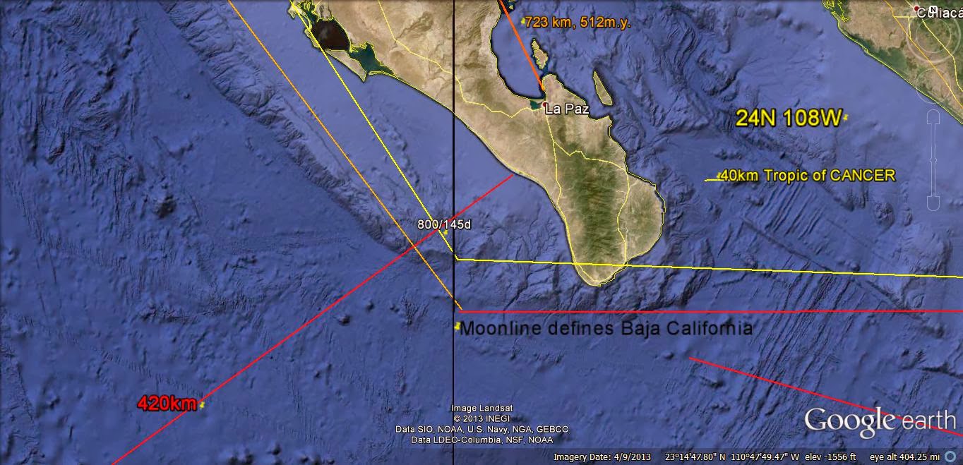
The MOON is the DOMINANT FORCE, gravitationally speaking, and it has the MOONLINE determined by the Equation: (360- x)/x= 5.615 degrees INCLINATION to the Ecliptic Plane; x= 58.5842 degrees. This SUBTRACTED from the PRIME NATURAL MERIDIAN, 169.6= 110.01579W Longitude. This is the MOONLINE:

This might NOT be recognized, except for the LITTLE COLORADO R iver, near, Tuba Cty, AZ. But it leaves its IMPRINT on Baja Peninsula:

Above is shown WHY the 1777.777km SEGMENTS are placed at this IMPORTANT CRITICAL LOCATION; the COORDINATES are FRACTIONS of the 360 degree circle (23N 111W, near 24N (1/15) 108W- 360/3.33333)!
The MOON has TWO separate N-S linears, from 2 RATIOS:
The Inclination of our Moon is 5.145 degrees to the Solar System Ecliptic Plane, separately from the TILT in relation to Earth. This FEATURE creates 2 separate REFERENCES, with the second related to the 3.6 degree SHIFT of the Polar Axis each 41 million years. 5.145/3.6= 1.42916667, which dividing in the EQUATION: (360-x)/x= RATIO, yields x= 148.199.
Reference to the 169.6 degreeW Longitude of the Natural Prime Meridian yields 21.401,degrees, East of the Diomedes. This is plotted as a MERIDIAN on Google Earth- which is near the MAR, South of Iceland:
Moonline 4 south: 21.4W

Lomonotov Ridge is the PREVIOUS REFERENCE, which has moved 400 km to the ACTIVE GAKKEL RIDGE:

BIFURCATION was INITIATED at the below JUNCTION:


ONLY the Moon creates ROTATION-SHEAR-EXPANSION at the Arctic Ocean; this requires a second MOON LINE- one where the 5.145d INCLINATION/3.6d SHIFT= 1.4291667 RATIO determines the N-S LINE:
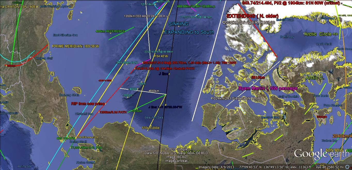
BYAM MARTIN Island has been formed in the last 4 m.y., and this will be RE-CHECKED:


The "KEY" to the Arctic MOVEMENTS is the SHIFT from the Lomonotov to the GAKKEL RIDGE, within the last 41 (40.96?) m.y. This created the "GAP" in the Qsna ELLIPSE (of 3 total):

A "HOLE" that can be accessed, COMMERCIALLY, is Meteor Crater, AZ which might have had a CONCOMITANT SMALL STRIKE, but which lies on CRITICAL COORDINATES!
Meteor Crater, AZ is a COLLAPSE FEATURE, formed by the Moon's ORBITAL Inclination ANGLE from the Ecliptic Plane of the Sun:
EQUATION (360 degrees-x)/x= Inclination angle of 5.145, yields 58.5842148 degrees from the Prime NATURAL Meridian. This is the SEPARATION of the NA Continent from Asia at 169.6W longitude, at the Diomede Islands. Finding the location referenced to the Greenwich Meridian is a subtraction= 111.01579W- which is the longitude of Meteor Crater. This is equivalent to 111d .9474", or 111.1degrees, within the ACCURACY of the measurements (3 significant figures, at most). This is also the number of km/latitude degrees, from 180/1.62 (Venus ratio of days/earth days, 81/5 or 365.24/225.46)= 111.111, and the RATIO of 40,000km/360 degrees= 111.111km/degree of Latitude!
Meteor Crater is a SINK- which fits the finding that circular HOLES are arranged along a N-S LINE by LATERAL GRAVITATIONAL shear. This is shown by the Google Earth view for the ROUND FEATURE:

EXPANDED, to find the ERROR of the process:

FINDING the most likely DIVIDER:

\
Also of interest is the Crater Latitude of 35.016N, which is near 360/10.24= 35.15625 degrees (measured at 360/35.01= 10.28, with my normal engineering ERROR). The ratio 10.24 is another CRITICAL NUMBER for the stability of the Earth, within the GRAVITATIONAL SYSTEM!

The URANUS LINE will be IMPORTANT for determining ANOMALIES which depend upon REVERSAL, even though the Planet is EXCESSIVELY DISTANT:
EQUATION (360-x)/x= .772908 degrees; X= 203.056222; subtracting 169.6= 33.456222, or 33d 27' 22.4"W. This must be plotted as a N-S linear, to search for ANOMALIES.
U line occurs at Lomonotov Ridge:

Above FEATURE is ANOMALOUSLY moving EAST from Lomonotov to ACTIVE GAKKEL ridge; below the South Georgia ANOMALY is also moving EASTWARD:

SUBDUCTION is occurring, as shown by the DARK ARC of shallow CRUST moving over the top of that to the EAST. Although this is in the Southern HEMISPHERE, and ROTATING CW (RISING), it is REVERSE to normal earth TIDES!

Above shows an INFLECTION in the MAR Half FIGURE 8 TREND!
The S line of INCLINATION= 2.49424d yields a N-S LINE at 66 34'23.9"W Longitude. This has an ANOMALY at the Antilles- SIMILAR to that of the Uranus line at the S.Sandwich Islands in the SOUTHERN Ocean:

WEATHER and Atmospheric TIDES: