
When the Sun and Moon are in
OPPOSITION (on opposite sides of EARTH), the CRUST is stretched (extended) MORE THAN
NORMAL- since the moon is approximately 50,000 kilometers closer to earth than at
NEW MOON.
When the Crust of the EARTH is
already stressed- due to GRAVITATIONAL LATERAL (sideways) movement, caused by
the combined influence of all the other SOLAR SYSTEM MASSES- the closer moon
acts as a “TRIGGER” for sudden movement. Look for slumps, down-ward moving
faulting, and LANDSLIDES. These are NOT GUARANTEED, but June 24 after midnight
there will be a time of SIGNIFICANT RISK:


The FULL MOON of April/2013 produced a SIGNIFICANT SLUMP at Ledgewood, Whidbey Island, WA:


The Ledgewood FULL MOON SLUMP is shown above and below:

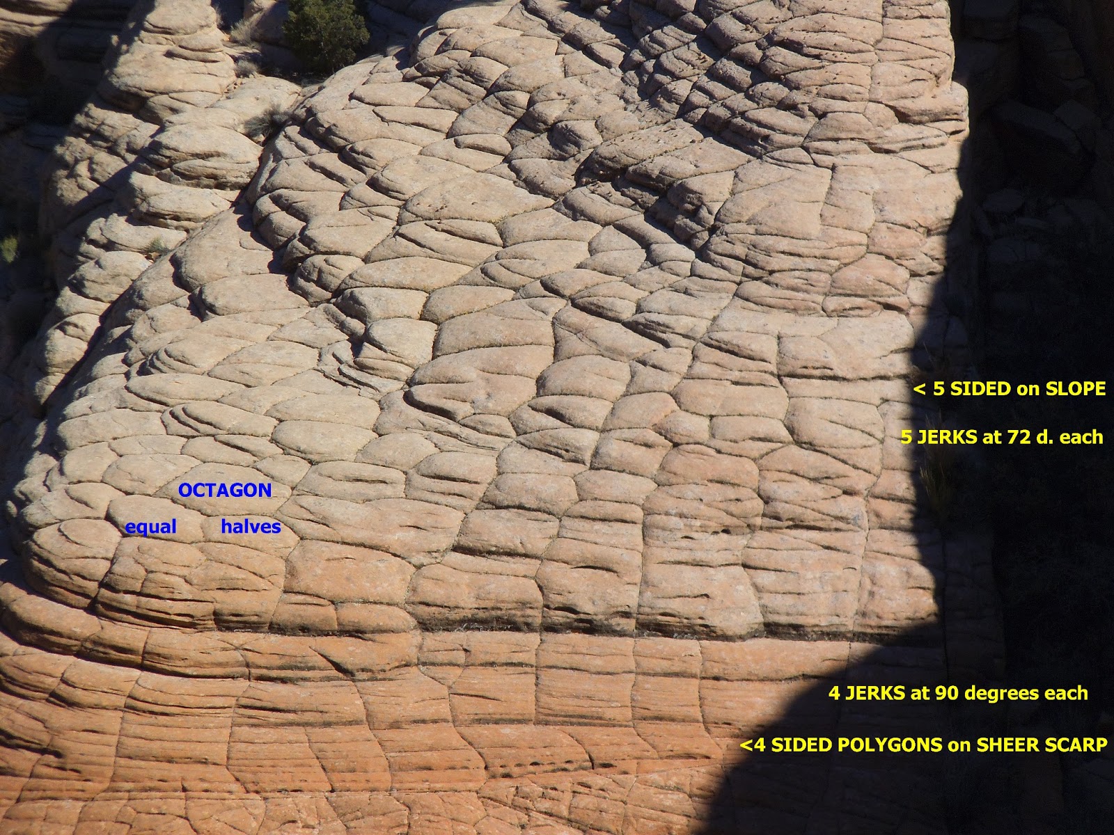
The EARTH'S CRUST develops POLYGONS with time; these are shown in SMALL SCALE for the Yellow Knolls north of St. George, UT:

POLYGONS above are shown in DETAIL, below. These are METER-SIZED, and have been GRADUALLY SHEARED, ROTATED, and RE-ARRANGED with GRAVITATIONAL LATERAL MOVEMENTS! My CASE HISTORIES have shown that they are sheared monthly, by the LUNAR INFLUENCE (requiring a MUCH LONGER TIME for the EXHIBITED POLYGONS!). They are 4-sided (PARALLELOGRAMS) for the VERTICAL SCARPS measured by GEOLOGISTS, but BEHIND the scarp there are MULTI-SIDES (the face seen by the field worker being a side of a polygon WITH MORE than 4 SIDES. With approach to the HILLTOP behind the scarp, there is a gradual increase in number of SIDES! In other words, the rectangles are GRAVITATIONALLY-ADJUSTED with TIME- due to shearibg and rotating. The RECTANGLE is SHEARED in an ARCUATE SLICE- becoming a slab with more than 4 sides. With SUFFICIENT TIME, the rectangle becomes a DECAGON or OCTAGON! This occurs for the SMALL SCALE shown, as well as for REGIONAL and CONTINENTAL FIGURES!


COLORADO PLATEAU, above and the BAJA PENINSULA SEGMENT below, show the POLYGONAL SIDES for LARGER REGIONS:

The smallest arrangement of LINEARS- which I call "TIC MARKS" is shown on a block of MONZONITE, for a portion of the PVM Laccolith, which has been ROTATED away from the PARENT MASS:

ROTATION-SHEARING has produced CHARACTERISTIC SLICKENSIDES:

ROTATION occurs about the "CENTER HOLE" which exhibits MAXIMUM ROTATION (degrees/time interval) and MINIMUM MOVEMENT (lateral shift)!

Another DAMAGED ROAD occurring at FULL MOON occurred at the Washington City, UT trail, where a portion of the hiking path was sheared and later repaired:

ONGOING DAMAGE OCCURS at the Chapel Road, Santa Cara, UT mud SLUMP:


CENTERHOLE shown previously develops from a small SINK in the middle of an ISOLATED BLOCK of crust and opens with TIME into a shearing LINEAR and finally as an ARCUATE DIVIDER BETWEEN 2 SEPARATE BLOCKS:

GRADUAL SHEARING-ROTATING-ADJUSTING blocks of SANDSTONE are shown below:


Grandpa's POND adjacent to the Virgin River EXHIBITS a SMALL ROTATING ELLIPSE which has produced ROAD DAMAGE on the north side (below the SCARP):

GET the PICTURE? CONSIDERABLE DAMAGE occurs monthly, and is AUGMENTED with time!

Mima Mounds are NOT RARE, and are easily viewed when the VEGETATION is kept trimmed; they occur and are AUGMENTED with the NEW MOON (COMPRESSION):

GOLF COURSES exhibit MIMA MOUNDS excellently, since the grass is encouraged, and the MOUNDS-SINKS are obvious!

Search for MIMA MOUNDS- they are not RARE, just obscured by vegetation, thought processes, or GEOLOGIC DOGMA:
ROCK FALL occurred below Middleton Mesa during the spring, 2013:

The BOULDER bounced and landed beside a woman sleeping in the bedroom; normally, she would have been at that spot, but her husband was gone, and she occupied his BETTER LOCATION:

"JERKS" may be counted in scarps, and the FREQUENCY may be determined after dating the 16 occurrences, below:

LIQUIFACTION of soil or sandstone occurs in a CIRCULAR CONFIGURATION, after COMPRESSION from below (NEW MOON, NOT a full moon):

FULL MOON produces slumping instead:


BOTH SINKING (WTHOUT MORAINES) and RISING (mounds) are shown in what geologists call KETTLES:


A KETTLE has been excavated for gravel; it lies next to a MOUND:

MORE SLICKENSIDES PRODUCED by ROTARY SHEAR:


Above Quail Lake, UT remains a 100 year concrete AIRCRAFT BEACON SLAB; it has experienced SHIFT, ROTATION, and UPLIFT during that period.


NEW MOON ACTIONS are the INVERSE of that with the FULL MOON (geometrically ORTHOGONAL):
The correlation of thrusting and
quakes with the NEW MOON can be made with observable events- such as the Haiti
SHIFT during the quake of 5 pm, 12 Jan 2010- NEW MOON on 15 Jan, 2 days later (7.0 magnitude at 18.457N 72.533W). This killed over 100,000 people and was NOT SIMPLE! The new
moon would have been only the TRIGGER. And the ENERGY would have built up over
years- as the COMBINED LATERAL STRESS of all of the SOLAR SYSTEM forces stored
their potential energy in the SLIGHTLY PLASTIC CRUST (waiting for the trigger for
release, because of the crust NOT BEING RIGID-ELASTIC). I will document events
as they occur, with the digital camera:


 DIRECTION of LATERAL FAULTING may be determined by the siltation narrowing direction; it is RIGHT-LATERAL on the Caribbean side and LEFT LATERAL on the Bay side. This indicates a CCW movement- agreeing with RISE of the PENINSULA! Overall information indicates that:
1. 18N latitude is NOT the key, this latitudinal anomaly is to the south;
2. PROTRUSION of the peninsula to the WEST is the most PROMINANT INDICATOR (a linear "TIT" showing westward EARTH TIDES);
3. LINEARS are secondary:


ARCS are in shallow ocean water, and must be dated by CALCULATION/1000:


1. 18N latitude is NOT the key, this latitudinal anomaly is to the south;
2. PROTRUSION of the peninsula to the WEST is the most PROMINANT INDICATOR (a linear "TIT" showing westward EARTH TIDES);
3. LINEARS are secondary:

There is a CONSIDERABLE AMOUNT of INFORMATION SHOWN- both ON and OFFSHORE:


This is CONTINUED in a separate BLOG SUBMISSION!
Hawaii EXHIBITS a CONTRAST, ORTHOGONALLY- at the JUNCTION of N-S GRIDS and E-W SHEARING:

I stumbled onto this MENDOCINO TRANSFORM FEATURE of near 40 m.y. AGE, and must include it as an INDICATOR for future investigation of DATING, since the calculations agree that it 'BELONGS" to the PERIODIC INSTABILITY of the crust at 41 m.y (40.96?). There the poles tilt by 400 km or 3.6 degrees- 1% of the circle or 40,000km circumference- from their PREVIOUS POSITION (shown by the shift of Lomonotov to Gakkel ACTIVE RIDGE):
I will now introduce DIFFRACTION WAVE PATTERNS- the next blog topic- with a VIEW of one from the PUGET SOUND REGION:


SPACING AVERAGED 11.6 k.y between E-W GRIDLINES ORIENTED N-S. This does NOT AGREE with the previously calculated 116 years, since these LINEARS are not influenced by OCEANIC TIDES (with 1000 DIVIDER). AGE of the 2 GLACIALLY-EXCAVATED ARMS (Penn Cove and Holmes Harbor) is approximately the same- near 135 k.y. from EXTENSION- PERPENDICULARLY across the arm- of the lobes through TIME!
