 ABOVE ANALYSIS AND CALCULATION OF THE EARTH TIDES MOVEMENTS AND RECURRENCE OF THE NEW MADRID ACTIVITY YIELDS 650 YEARS FOR THE CYCLICITY OF THE DISCERNIBLE EARTHQUAKES. THIS IS DUE TO THE ROTATION CCW FOR THE BLUFF SIDE OF THE RIVER, VS. CW FOR THE MISSOURI SINK SIDE and THAT THE SHEAR PROCEEDED NORTHWARD ON MY FARM, WHERE THE FIRST QUAKE OF DEC 1811 OCCURRED. LATER QUAKES OCCURRED PROGRESSIVELY NORTHWARD, SHOWING THAT THE CRUST WAS SPREADING FROM SOUTH TO NORTH. THIS IS SIMILAR TO TWO INTER-MESHING GEARS, WITH THE OPENING ON THE SOUTH SIDE AND THE ROTATION CW ON THE LEFT (west) GEAR.
Solution to New Madrid, MO Dynamics and latest quake of 1811-12
There is active movement around the LARGEST EARTHQUAKE ZONE in the USA, where I have found artesian pressure, abnormal chemical composition of well water, and evidence of “SAND BLOWOUTS” from the activity there. Information is available from state records, for shallow water well water composition and strata penetrated, to form a contour map on the anomalous zone inside the graben near Big Lake, and I have analyzed these. Two hydrocarbon test wells have been drilled in the anomalous zone, but only shows of gas have been found. First look at the location map and a large view of the shear circles and creek orientations available on GOOGLE EARTH. Below are obvious ellipses and circles surrounding the various entities near the Mississippi River:
 The SEPARATION OF THE TWO SHEAR ELLIPSES IS DUE TO THE SEPARATION, IN TIME, OF THE KT AND EO EVENTS. THE REASON WHY FIELD GEOLOGISTS HAVE NOT USED THIS INFORMATION, IS DUE TO THE VERTICAL DISPLACEMENT (WHICH IS GENERALLY SUFFICIENT FOR THEM) OBSCURING THE LATERAL MOVEMENT- WHICH IS LESS THAN THE VERTICAL. THE PRINCIPAL WAYS TO FIND THE LATERAL ORIENTATION AND MOVEMENT IS VIA SLICKENSIDES, FRACTURE OF CONCRETE SLABS, AND RIVER PATTERNS AS THEY ARE DRAGGED BY THE ROTATING BLOCKS OF CRUST.
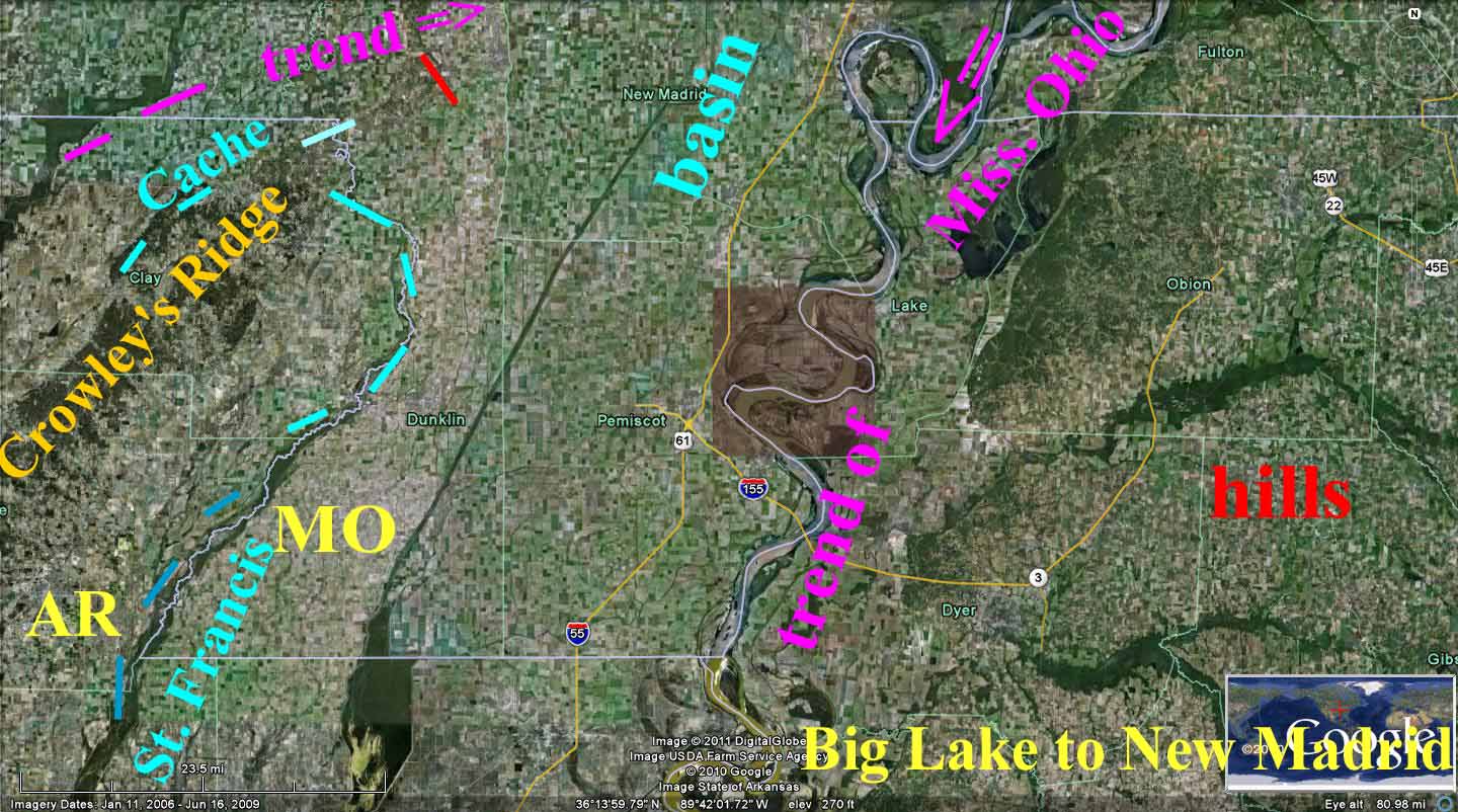
Notice that the anomalous zone (ellipses and shear indications) is large- extending from the major bend in the Mississippi River at Cairo, IL and the Ohio River to the Arkansas River. The first conclusion is that the highlands of Kentucky and Tennessee rotate CCW east of the river- opposite to that to the west, where lowlands occur. This is shown by river orientations and drag of bluffs and sinks on either side of the rivers:


There is a tremendous amount of information available, and by sorting it, one may be able to establish rules for other TRIPLE JUNCTIONS. NOTE THE POSSIBILITY OF ANOMALOUS HEAT, Gt:

THIS IS A LARGE FEATURE. NOT ONLY HAS THIS BEEN THE FULCRUM FOR THE LARGEST QUAKE IN KNOWN HISTORY OF THE USA. THERE IS NE-SW BIAS, AS WELL AS E -W EXTENSION FROM THE KT ROTATION OF THE GREAT PLAINS VS. THE REGION EAST OF THE MISSISSIPPI RIVER (SINKS TO THE WEST AND BLUFFS, MOUNTAINS TO THE EAST).
Above photos pertain to my farm, where a graben occurs, with sand “blowouts”, artesian pressure- IN A COUNTY WHERE THERE IS ONLY 30 FEET DIIFFERENCE IN ELEVATION MAXIMUM (MISSISSIPPI DELTA), and faulting. Deep drilling indicates that Paleozoic formations exist below the Mesozoic and Eocene. Interested earth scientists should obtain records of wells in the large meanders at New Madrid and at the intersection of the Mississippi and Ohio rivers, since there should be anomalous geothermal gradient or temperatures there.
IT IS MY CONCLUSION THAT MEANDERS, SUCH AS THESE, ARE CAUSED BY WOBBLE OF THE POLES, AS THEY ARE IMPACTED BY BINARY THEOREM EVENTS (MOST IMPORTANT), MONTHLY EARTH-MOON CYCLES, OR OTHER LUNAR-SUN CYCLES. WE WILL SLOWLY FERRET THESE OUT, AS I GET NUMERICAL INFORMATION FROM CALCULATIONS OF RATE OF MOVEMENT AND TIMES OF CYCLICITY. YOUR INPUT WILL HELP SOLVE THESE VERY COMPLICATED INTERACTIONS.

BELOW IS A PHOTO WHICH ALLOWS INSPECTION OF A SMALL GRABEN in Utah- TO ALLOW RECOGNITION OF THE GENERAL OUTCROP APPEARANCE:


CLOSER TO MY FARM IS A GRABEN, WHICH HAS MANIFESTED ITSELF AS "BIG LAKE"- a FISH AND WILDLIFE PRESERVE. THIS LOCATION HID "MOONSHINERS" IN MY BOYHOOD DAYS, AND IT NOW SUPPLIES HABITAT FOR DUCKS AND BEAVER. IT ALLOWED "BOOTLEG" OPERATIONS, SINCE THE DISTILLER WENT TO TOWN WITH GUM BOOTS TO CARRY BAGS OF SUGAR. IF YOU TOOK OFF HIS BOOTS, THERE WAS THE EVIDENCE- BUT THE "FEDS" NEVER GOT THIS CLOSE TO THE "JAKELEG" TO INTERROGATE HIM. "JAKE LEG" WAS A TERM GIVEN TO ONE WHO HAD GOTTEN THE WRONG TYPE OF ALCOHOL- METHYL, RATHER THAN ETHYL- AND WHO WOULD SOON DEVELOP WOBBLING OF THE LEGS BEFORE DYING.
 BELOW IS AN ANALYZED PICTURE, WHICH ATTEMPTS TO START MEASUREMENT OF THE EXTENSION CREATED ABOUT THE MISSISSIPPI RIVER GRABEN AND ELLIPSE. THIS IS JUST A START, AND I AM NOT SURE THAT I HAVE THE RIGHT LOCATIONS OF THE KT and SUCCEEDING EVENTS. NEVERTHELESS, WE WILL CONTINUE, SINCE IT WILL BECOME CLEAR WITH LATER ANALYSES WHICH PROCEDURE WILL BE THE CORRECT ONE:
Big Lake Graben and Lowlands, Mississippi county, Arkansas
The lowlands of Missouri and Arkansas parallel the GENERAL TREND (N-S) of the Mississippi, but do NOT drain towards the great river until reaching Helena, AR. This is generally a SSW trend, as is the course of the master river. This is shown on the preceding Google earth maps, and is the result of the impingement of the two great movements created by the BINARY THEOREM-PREDICTED EVENTS- which have formed shear ellipses around the area and which show an interdiction on the east side of the river. The whole region has undergone considerable erosion and weathering since these ancient dates, and surface geology investigation is limited to Bluffs along the Mississippi River and Crowley’s Ridge to the west. There are a few hydrocarbon tests and shallow water wells which yield some information.

I will make an evaluation for my farm, which is located in Sections 10 and 11, T14N, R9E, for lands along the east side of Big Lake between two levees (one to the west, I will name OLD- trapping flow from Missouri drainage, and New, east of the graben and which prevents flooding into agriculture lands). This graben-bordering area has artesian pressure in shallow water wells and has anomalous water composition (high sulfates and bicarbonates).
Further, there are sand “blowouts” mingled with the “gumbo” soil of high organic and black constituents. THIS IS ALL DELTA LAND WITH FLOOD DEPOSITS AND RICH SOIL FOR COTTON. Below is a Google Photo of the Big Lake graben and adjoining lands:

NOTICE THE MEANDERS OF OLD CREEK PATHS- TO THE EAST OF THE BIG LAKE GRABEN. THESE HAVE MOVED CONSIDERABLY- INDICATING THAT THERE WAS A MAJOR STREAM IN THE DISTANT PAST. I HAD WONDERED AT THESE "SLOUGHS" IN MY BOYHOOD DAYS, AND NOW I SEE THAT THERE WAS A LARGE DRAINAGE (NOW FILLED-IN) IN THE PAST. FARMERS HAVE GRADUALLY FILLED THESE WITH NEW TECHNIQUES AND LARGE LEVELING TRACTORS, SO THAT THEY MAY NOT BE NOTICEABLE NOWADAYS. ARTIFICIAL DISTURBANCES SHOW THAT MAN CAN DISRUPT THE "NATURAL INTENTIONS" OF THE DYNAMICS OF THE EARTH. HOWEVER, NATURE WILL OFFSET THESE IN ITS OWN "GOOD TIME".
THIS IS SHOWN IN DETAIL FOR THE GRABEN FAULTING, WHICH IS DOWNTHROWN TO THE NW, WITH A GEOCHEMICAL ANOMALY ON THE UPTHROWN SIDE. GAS SHOULD MIGRATE TO THE HIGH SIDE, CREATING HCO3 (BICARBONATE) AND SULFATE ANOMALIES- SEPARATED BY THE METHANE DEPOSIT, IF YOU CAN FIND THE TRAP!
 THE FARM AT THE SE EDGE OF THE GRABEN- WHICH CONTAINS EVIDENCE OF "SAND BOILS", ANOMALOUS WATER COMPOSITION, AND ARTESIAN PRESSURE- IS SHOWN BELOW, WITH A LARGER VIEW OF THE ANCIENT TRACES OF THE ALMOST-DRIED UP LITTLE RIVER. THIS MIGHT HAVE HAD CONNECTION WITH THE ANCIENT MISSISSIPI, BUT THE TRACES AND MEANDERS ARE NOT QUITE LARGE ENOUGH TO HAVE CARRIED THE LARGER DRAINAGE:
 THE DYNAMICS OF THE GRABEN MOVEMENTS- THE DRAG OF THE BORDERLANDS, THE SHEAR OF THE STRATIFGRHIC COLUMN, AND THE UPTHROWN HORST ARE SHOWN BELOW:
ALL OF THIS OCCURS DUE TO POLAR WOBBLE ROTATIONS AND THE ON-GOING DYNAMICS ASSOCIATED WITH THEM- THE NEW MADRID EARTHQUAKE, ROTATION OF THE CELL EAST (CCW) OF THE MISSISSIPPI RIVER VS. THE COUNTER-ROTATION OF THE CRUST WEST OF THE RIVER (CW).

ANECDOTAL INFORMATION:
The YEAR 1811 (THE INITIATION OF New Madrid EARTHQUAKES) was reputed to be a catastrophic year- in terms of natural events. Tecumseh’s comet had passed and been visible most of the year, terminating in 1812. This has peripheral value to an analyst, who is searching for clues for the QUAKE TRIGGER. The cycle of the comet is near 3065 years, and was thought to have passed in the time of Ramses II-about 1254 B.C. Google search reports that the cycle is 3065 years, and that the asteroid has a diameter of 685 km? Harmonics of 3065 exist, approximately, at 11 (sunspots) x 28 (moon cycle)= 308 years. Using a moon, full-to-full cycle of 27.5 days yields:
27.5 x 11 = 302.5, a 1/10th Harmonic of the comet cycle.
Possibly Tecumseh’s COMET added to the stress already present on the GREAT SHEAR CYCLE OF THE TRIPLE JUNCTION AT THE CONVERGENCE OF THE MISSISSIPPI AND OHIO RIVERS. The fact that there were sand blow or “Sand boils” some 10’s of meters in length indicates that there was large stress already present, at this convergence of shear circles, and some outer event might add sufficient stress to cause it to occur sooner than it would have otherwise. But my analysis is that the large circular rotations on either side of the Mississippi River are driven by the EARTH’S CONTINUAL OFFSET AND CORIOLIS ROTATION OF THE BULGES CREATED BY THE PTr, Kt, and later EVENTS. Witness the Tonga trench- the fastest moving opening in MEASURED science information- which is moving under the impetus of the PEAR-SHAPED EARTH, created by the PTr collision on the south coast of (present) Australia. This separation of Antarctica and Australia is on-going, and is documented on this blog in earlier submissions.
Taking the small portion which contains the BIG LAKE, AR GRABEN (bordering my farmlands), there is a great ELLIPSE, containing the white-lined LINEAR. This is an ANALEMMA, when viewed from a large perspective:

This region is the INTERMEDIARY between the CCW rise to the east, the CW lowlands to the west, and the GREAT ARC SOUTHWESTWARD to Hot Springs, AR. This arc leads to the diagonal crossing OK and TX- a much older entity. It is another TRANSITION ZONE, similar to that betweeen the "Wasatch Line" of UT and the Parashant fault of AZ-UT:

This is viewed in CENTRAL TX to the Gulf - a movement from 100 m.y. to 72 m.y., revealing that the Cretaceous of TX has "enveloped" the later KT formation of the Gulf, under varying TIDAL RATES from 5 mm/yr in the Gulf center, to large at the extremity (indicating that the Gulf is SPIRALING DOWNWARD at a faster rate than normal:

This will all 'impinge" on my AR farm, where a GRABEN has formed before and after the great New Madrid QUAKE of 1811-12 (200 years ago, and a fore-runner to FUTURE TOWN-KILLING SHAKES).
Below is a portion of the GREAT ROTATIONS spreading over the last 150 m.y., as seen in the ARCS CONCENTRIC with the GREAT LAKES FULCRUM (notice the spiraling on GOOGLE EARTH of the lakes- in theform of OBVIOUS ROTATIONS CW):

Expanding the view, there are larger diameter ARCS- which project older EARTH CRUSTAL ROTATIONS. The oldest for this feature is no more than 150 m.y., and it has been mostly OBLITERATED by EROSION:

This must be done by TRIAL AND ERROR, since it is not known in advance, the MAGNITUDES of the appropriate TIDAL RATES, CONCENTRIC CIRCLES, and starting time of INCIPIENCE:

After "lifting by one's own BOOTSTRAPS" the more accurate magnitudes may be solved, and then the RECALCULATION yields an almost FINAL AGE, RATE, and FULCRUM:

There exist ERRORS of MEASUREMENT, CALCULATION, and personal SKILL, so that there is still near 5% UNCERTAINTY. This means that when I find an AGE, its variation is on the order of +- 5%: e.g. 150 m.y. Cretaceous might be as low as 142.5 and as high as 157.5 m.y. for lower limestones, before the late Cretaeous RISE of SEA LEVEL. Incidently, this will explain the UNCONFORMITIES above the Edwards Plateau, the loss of Mid-Cretaceous, and the DEPOSITIONAL CHANGES from lower to upper (limestones to sand-shales regime).
Now we have to ask: what does this have to do with the New Madrid quake, and the answer is that the ELLIPTICAL CCW ROTATION of the North American continent, Qsna, influences all movements contained within- down to the smallest outcrops. Notice the movements in the great circle south of the Great Lakes:

Smallest EXHIBITS occur in ROCK SAMPLES which have been subjected to SIMILAR ROTATIONAL SHEARING from POLAR WOBBLE-EARTH TIDES:


These are not RARE FINDS, but loose rocks I find on every HIKE in an ANOMALOUS AREA (one displaying OBVIOUS SHEARING CURVILINEARS):

Above are MOQUI MARBLES,and below is a CYLINDRICAL CONE, sheared and CONVOLUTED by LATERAL ROTATIONS:

A NEW REFERENCE for the North American QUADRANSPHERE- Qsna, is shown BELOW to indicate that added information is found by the DAILY SATELITE WEATHER GLOBE, from ATMOSPHERIC TIDES- which perform simiarly to EARTH TIDES. This can be used in a GENERAL SENSE, to obtain movements from day-to-day that would occur on a million year SCALE in the EARTH'S CRUST:

The UNLINED VERSION shown below can be used to eliminate my ANALYSIS:

Information in newspapers of the time indicate that the quakes started on the 16th December, 1811, near Big Lake, AR, and that the progression was NNE from there towards New Madrid, MO. Valuable would be whether there was a FULL MOON at that date or a few days earlier. BELOW IS SHOWN HOW A FULL MOON OF JAN 2011 INFLUENCES MOST OF THE USA WEATHER, FROM CA TO AR. NOTE THE HIGH PRESSURE CIRCLE OF EDGE CLOUDS WHICH EXENDS FROM THE PACIFIC TO THE MISSISSIPPI RIVER. THE MOON ACTS TO EXTEND THE BULGE IN THE EARTH, BUT IT MOVES WITH THE ROTATION OF THE EARTH. TEMPORARILY, THE FULL MOON ADDS STRESS TO THAT OF THE INCIPIENT STATE, WHEN IT IS OVERHEAD (AS DOES THE OPPOSITELY-LOCATED SUN):

THIS WILL CONTINUE, REQUIRING FIELD OBSERVATIONS ON CROWLEY'S RIDGE, BLUFFS ALONG THE EAST SIDE OF THE MISSISSIPPI, AND LOCATION AND ANALYSIS OF SLICKENSIDES ALONG THE OUTCROPS. THOSE INTERESTED SHOULD SEND PIX OF ANY ANOMALOUS FEATURES IN ROCKS ON BOTH RISES.


