
Whidbey
Island is an ISOLATED CRUSTAL BLOCK- separated by sea water from neighboring
islands and the WA mainland. It is developing now- since the ICE AGE- and is
generally no older than the 2 m.y. ELTANIN EVENT, which produced the elongation
from north to south (NOTE the measured time interval and the EXPECTED DIAMETER of 2.048 km- 2 m.y.- where the ERROR of 5% is displayed. This may mean that the GLACIATION FEATURE is ON-GOING, or it may be merely the error of the process. This is shown for the whole island, which is oldest at the
north and which is still elongating in this direction (map oriented with north
to left- rotated 90 degrees CCW, for maximum presentation):

I am taking one feature/frame, so that the DETAIL allows MINIMUM ERRORS of PRESENTATION. ABOVE, the combined Oak Harbor and CRESCENT HARBOR to the east are shown- divided by a USED-TO-BE TOMBOLO (Naylor Point). This feature has risen with REBOUND, but the ACTIVE SHEARING FRACTURES may be viewed just behind the NAVAL COMMISSARY. These continue to break the concrete roadway, and trend E-W. Notice that the next TOMBOLO to the east is not included in this ELLIPSE, and it includes an IDENTIFYING SPLIT in the mid-section- showing the LATERAL FAULT ORIENTATION.


The AGE can be calculated, using the diameter (E-W YIELDS THE MINIMUM- PRECESSIONAL, while the N-S YIELDS the MAXIMUM, due to the COMBINED AXIAL + PRECESSIONAL):

An OBLIQUE VIEW allows a 3D perspective:

A DIGITAL PHOTO shows the FAULTING ORIENTATION in the SMALLER TOMBOLO. There is a small vertical dispacement, but the main movement is LATERAL (note the near-horizontal shear features). Not only may the compass bearing of the fault be measured, but the IRON-STAINED HOST ROCK may be viewed (note the ARCUATE VERTICAL FAULTING):
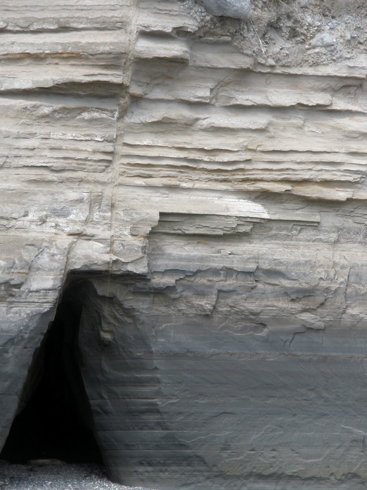
Finally, a HIKE ALLOWS a PEEK INTO THE CAVE formed from Lateral SHEAR:

The next SMALLER DIVISION of the ISLAND'S ELLIPSES-ANALEMMAS is shown below. The aim is to show you how an ellipse develops, first with an AXIAL ROTATION (FOLLOWED LATER by a PRECESSIONAL TILTING, IRREGULAR FEATURE- such as the Basin and Range vs. the Colorado Plateau, CP). These penetrate the older, and later are themselves PENETRATED by YOUNGER ANALEMMAS:

All this is DUPLICATED IN THE DAILY MOVEMENTS of the SATELLITE WEATHER CYCLES. Below is shown how a penetration of a small PHALLUS-LIKE LOW PRESSURE CELL develops within one day into a YOUNGER ANALEMMA (Figure 8)- I call this BIRTHING:


NOTE the progression of a SIMPLE PROTRUSION into a FIGURE 8 ANALEMMA, in ONE DAY:

NOTE: The future of ANALEMMA LATERAL ROTATIONS
may be determined by finding the daily shift of LOW PRESSURE WEATHER SYSTEMS on
satellite photos.
There is 365 x 1 million to one (365 m.y./day of WEATHER CELL MOVEMENT), for movements from one day to the next (365.242
days/year x 1 million). The views within a particular day can be viewed ONLY for
about 8 hours (1/3rd of a day) due to the sunlight putting GLARE (in SPACE) on
the TV SCREEN view. It is better
to watch the satellite at the same hour each day. Then, in one 24 hour day you
can find the change for some time interval in the FUTURE! For example, for the 2 photos
below, the ANALEMMA near ANTARCTICA (west, in the Southern Ocean) has “STRAIGHTENED”
in 10 days, yielding the TIME NECESSARY to develop the LINE ISLANDS and its counterpart in the SOUTHERN OCEAN. A GEOLOGIST SHOULD INQUIRE: "How can we see FUTURE EVENTS with this event happening IN THE PAST?" (The answer is: The forward end of the FEATURE relates what happened in the past, and the older part LOOKS TO THE FUTURE towards the FORWARD END):

Notice the CHANGE from an ANALEMMA (PROPELLOR-SHAPED), to a LINEAR in 10 days:

The LINE ISLANDS are in the N. HEMISPHERE,and the counterparts (Easter, Christmas I. etc). are in the south:

The location prior would have been (possibly)
eroded to later re-form. Consequently, the PRESENT PEAR-SHAPED BULGE has developed
since the EVENT and its ASSOCIATED TIME HARMONIC! Now I must "ferret out" a method for determining the particular harmonic: 365 m.y, 36.5 my. 3.65 m.y, 365 k.y, 36.5 k.y (approximately a 41k.y. MILANKOVOTCH CYCLE), 3.65 k.y., 365 years, or 36.5 years.

 A start for this CALIBRATION is with the ZION NP, UT SPIRAL, which I have already solved for the TIME INTERVAL INVOLVED. It is 1-2 m.y. in its development; since I viewed this in just one day on the earth satellite, this is equivalent to 1day of ATMOSPHERIC TIDES/1 m.y. CRUSTAL TIDES (365 million to 1).
 Another case is that for the CP-B and Range 41 year AGE DEVELOPMENT; again this 1 day spiral occurred for the 41 equivalency (41 m.y x 365 days/year = 14,960 million to 1, or a 40.96 RATIO HARMONIC). This is better, since the 41 m.y. TIME INTERVAL OCCURS REGULARLY (82, 123 m.y. etc):
FOLLOW THIS DEVELOPMENT and you will see how the CRUSTAL FEATURES are developing similarly to the WEATHER CELLS- THEY RISE-SINK, ROTATE, and SHEAR on a DAILY BASIS. THERE ARE HARMONICS for this, and we will view kilo-year movements (one thousandth harmonics of 365 k.y. or smaller one ten thousandths- 36.5 k.y. approximately one MILANKOVITCH AXIAL ROTATION; this would be 1521 years INTERVAL/hour of VIEWING TIME):


FOLLOW THIS DEVELOPMENT and you will see how the CRUSTAL FEATURES are developing similarly to the WEATHER CELLS- THEY RISE-SINK, ROTATE, and SHEAR on a DAILY BASIS. THERE ARE HARMONICS for this, and we will view kilo-year movements (one thousandth harmonics of 365 k.y. or smaller one ten thousandths- 36.5 k.y. approximately one MILANKOVITCH AXIAL ROTATION; this would be 1521 years INTERVAL/hour of VIEWING TIME):

Photo of ENTIRE LENGTH of Whidbey and Camano Island, with NORTH TO LEFT:


Island County includes Camano Island, and FORTUNATELY includes the HALF ELLIPSE of 1 m.y. shown in RED:

This is EXPANDED TO SHOW the older, LARGER ROTATIONS:

This is ANOTHER CASE of a SPIRAL, and in this ROTATION of 100 k.y., it is a SPIRAL DOWNWARDS for the seawater part and UPWARDS for the CAMANO LAND RISE (notice the 4 quadrants: Camano rise vs Skagit Bay sinking and Silver Lake PROMONTORY vs. Saratoga Passage sinking). I have a collection of these- including the ZION NP, UT RISING SPIRAL:

 Continuing with the Whidbey-Camano- Skagit SPIRAL. Why is ZION Rising, while Skagit Bay is sinking? The ANSWER IS: ELLIPSES OUTWARD from the SUN and the FULL MOON PRODUCE SLOWING-EXTENSION, while the NEW MOON-ACCELERATION PRODUCES COMPRESSION, on a kilo-year TIME BASIS!
NOTICE LARGE TIDAL RATES at EDGES,and SMALL near the FULCRUM of the 1 m.y. Spiral. This confirms (with the CROSS-CHECK of rates, by DIAMETER, ROTATION CENTERS, and distance between fulcrums) that this is the CORRECT PROCEDURE (ALSO THIS CALCULATES THE VARIABLE ROTATION RATES, by noting that there is a GRADATION of RATES BETWEEN SUCCESSIVE CIRCUMFERENCES of rings within rings):

REVIEWING:
I had assumed that Penn Cove had ROTATED SUBSEQUENT to the 15,625 year HARMONIC, but this analysis shows that it had been forming since the 100 k.y. TIME! These rotations are gradual, with the termination near the 15,625 year AGE:

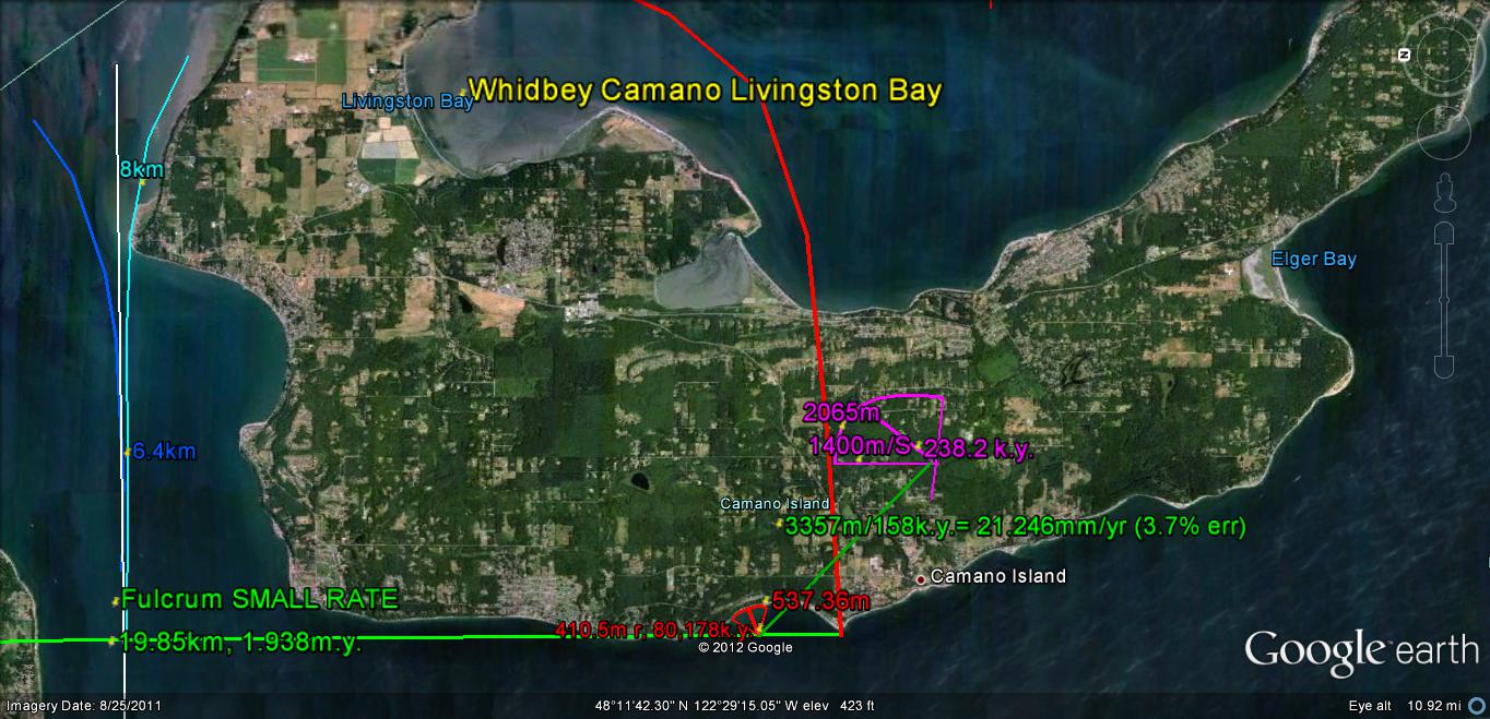
The SPIRAL slicing Camano and part of Whidbey
Island indicates that the TIDAL RATES VARY with distance from its FULCRUM! I have refined this calculation to
show the location of the large and small rates. It varies according to the
QUADRANT of the ELLIPSE. It has the 40mm/yr. rates at the SW corner, with the
SMALLER 5 mm/yr. in other QUADRANTS!

This has been checked by analyzing ARCUATE
FEATURES near the ELLIPSE EDGE, to determine whether my INITIAL ASSESSMENT was
CORRECT. There were initial ERRORS, which indicated that the 1 m.y. ROTATION
was ON-GOING. This was correct, and it appears that the ICE AGE REMAINS! My conclusions overall are that the EVENT
CONTINUES until 2.048 m.y. have elapsed (2.15, according to the GEOLOGISTS’
RADIOACTIVITY MEASUREMENTS). Considering
GLOBAL WARMING- an ARTIFICIAL MODIFICATION- we should discount the process, but
the SPIRALING FINDING should be VALID!
Referring to WEATHER SATELLITE DISPLAYS, there
do occur spirals, and we should try to determine their CONTRIBUTIONS. Photo
below shows that ANALEMMAS (FIGURE 8s) occur, and have two separate ARCS- LUNAR
and SOLAR- so that there is always a SEPARATION of the Spiral into 2 parts:

EXPANDING , to see the details of the Spiral over ZION NP, UT:

STAY TUNED, since there is a TREMENDOUS AMOUNT of INFORMATION AVAILABLE- not only by hiking the beaches, but with that shown on GOOGLE EARTH!


