

The latest volcano to erupt in the area, of a town now grown around it, is this basalt and ash landmark, known as Sullivan’s Knoll (alternatively, colina tinta- ink hill, black mountain, or rejuvenation of an older (> 1 m.y.) eruption- known as Ivin’s Mound. This breached crater (north side) is covered by ash and small ejecta, but is underlain by older black basalt, and it sits on the north flank of the older flow. This type of small basaltic cone is typified by a development noticed regularly in the Hawaiian Islands. Although the composition is different, the progression is similar:
1. A fairly quiet basalt flow results from the rotational friction created by two movements in the Crust, which are in conflict (as in Hf, the Hurricane fault, and the lateral fault created along the Virgin River by the uplift of the Zion highlands). Hf moves the Colorado Plateau, CP, to the south in a CCW ROTATION, while an asteroid strike on the opposite side of the earth (antipode) causes uplift of Zion, with its separate CCW rotation. Two rotations in the same direction (CCW vs. CCW) are similar to two adjacent gears trying to mesh in your gearbox, and the result is grinding, heat and conflict.
2. The CCW-spiraling eruption proceeds until the excess heat in the crust is dissipated, after which cooling and spiraling of the magma chamber causes shrinking, reverse rotation, and dragging of the surrounding crustal rocks.
3. Hawaiian Islands develop rejuvenation cones some million years after the primary eruption has cooled and spent it expansion.
This happens along the FRICTION-CREATING border of the previous magma chamber and neighboring brittle rocks, e.g. Diamondhead, Oahu- for a previous single large volcano, or Waikapu- for a boundary between two volcanoes, in the case of Maui. The case of Sullivan Knoll has erupted somewhat less than a million years after Ivin’s Knoll, and is expected to result from downward spiraling of the primary chamber, CW, with cooling and shrinking.
4. My measurements reveal that Sullivan Knoll is still rotating CW, but not ominously. This development has some heat of friction building up, and occasionally there is a stink of rotten eggs from the sulfides released by the grinding of the sulfates from gypsum and sulfur of previous emissions. This is particularly noticeable on a calm day, when I jog around the periphery of the cone. My neighbors complain of stinks and cracks running N-S through their driveways and curbs. The rotation seems to be more noticeable in the wintertime, when Hf is more active.
5. The geologic ages of the various eruptions have been measured by UGS, using radioactive dating. These can be obtained through the Geological Survey, and their emissions are not random, but are the result of frictional contacts between the great movements occurring in the region:

 ABOVE IS SHOWN SULLIVAN KNOLL, AFTER A WINTER SNOW, TAKEN TO DETERMINE IF THERE WAS A "WARM SPOT"- WHICH WOULD INDICATE HEAT FROM ROTATION. I DIDN'T FIND ANY, AND BELOW IS SHOWN A TYPICAL BASALTIC COLUMNAR JOINTING, WHICH APPEARS AFTER COOLING AND SHRINKING OF A LAVA FLOW:
a. Hf is oldest, being the result of the uplift of CP;
b. Basin and Range, B&R, lateral faulting tracing along the I-15 freeway (every saddle has a fault of some kind), after the Miocene event creating the Pine Valley Mountains (PVM, aged 22 m.y.);
c. Grass Valley and Sand Mountain rotations, created as far as I have found so far, by Miocene or later asteroid strikes. These have caused the Virgin River to lurch suddenly through new fractures across the uplifted Virgin anticline, at the edge of Sand Mountain; and,
d. Other vulcanism develops nearby, from the extension created whenever the B&R moves westward from Hf, at Anderson Junction on I-15. Extension connotes an opening of the crust, and the normally hot magma at the base of the crust merely emerges in these small cones as basalt (and not as violent rhyolites or andesite). These cones can be found on the north side of the Virgin River, south of Leeds, and west of Toquerville. Many occur north along the freeway at Hf, where B&R and this CP faulting coincide, as far north as the Ash Creek crossing of I-15. NOTE: WHEN TWO FAULT MOVEMENTS LIE ON THE SAME PATH, SUCH AS THE WASATCH LINE, THEIR SEPARATION CREATES AN EXTENSION IN THE CRUST AT THE POINT OF DIVERGENCE. INITIALLY, THIS IS AN ACUTE TRIANGLE, AT WHICH BASALT EMERGES; THIS LOCATION OCCURS AT THE HURRICANE CLIFFS EAST OF ANDERSON JUNCTION, AND THERE ARE MANY FLOWS NEARBY. AT THE TIME OF DIVERGENCE, THE TWO PROVINCES WERE AT EQUIVALENT ELEVATIONS, BUT NOW THE B&R IS SINKING AND THE CP IS RISING, SO THAT THE BASALT FLOW APPEARS HIGH ABOVE THE SMALL FARM THERE.

THE BEST METHOD FOR FINDING LATERAL MOVEMENT ALONG SIDE-WAYS FAULTING, IS VIA SLICKENSIDES OR SHEAR INDICATIONS (DISPLACED CRACKS) IN CONCRETE SLABS. AN EXAMPLE OF NEAR-HORIZONTAL STRIATIONS, CREATED BY SIDE-WAYS SLIDING OF A BLOCK OF CRUST AGAINST ITS NEIGHBORING ROCK IS SHOWN BELOW. USUALLY, THE EXTREME PRESSURE DISSOLVES SILICA AND DEPOSITS IT IN LOCATIONS OF STRESS RELIEF (SUCH AS IN THE FAULT PLANE WHERE SLICKS ARE FOUND). THIS IS MOST EASILY NOTICED IN CARBONATES, SUCH AS LIMESTONE OR DOLOMITE, BUT FOR SILICATE ROCKS ONE MAY HAVE TO "SETTLE" FOR IRON PLATING, WHICH IS SOFTER- FOR BASALTS, SANDSTONES, OR SHALES:
 BELOW ARE SHOWN SLICKS IN MONZONITE- WHICH IS THE INTRUSIVE IGNEOUS ROCK FOUND TO THE WEST OF ANDERSON JUNCTION, ON THE NORTH SIDE OF THE FREEWAY I-15:
 PHOTO ABOVE SHOWS THE RELATION IN SPACE OF SULLIVAN VERSUS IVINS KNOLL (WHICH IS MUCH OLDER). WHEN RISING, THE ROTATION OF A MAGMA IS CCW, AND I HOPE TO FIND THE POINT OF REVERSAL- WHEN THE MAGMA COOLS AND UNDERGOES CW ROTATION- HENCE A REVERSAL OF DIRECTION. SULLIVAN WOULD THEN OCCUR AS A RESULT OF "HEAT OF FRICTION" OF THE SPIRALING OF THE SPENT IVINS AS IT DESCENDS. THIS WOULD BE A "LAST GASP" DUE TO ROTATION AND NOT FROM THE ORIGINAL HEAT OF THE RISING MAGMA:
THIS IS A TEST, AND I DON'T PUT MUCH FAITH IN THE REVERSAL PATH SHOWN. BUT WE MAY USE THIS AS A STARTING POINT FOR A LARGER SURVEY OF VULCANISM, HOPING TO SORT OUT THE SPIRALS AND THEIR FAINTNESS VS. BRIGHTNESS FOR AN INDICATION OF THE DIRECTION OF MOVEMENT.


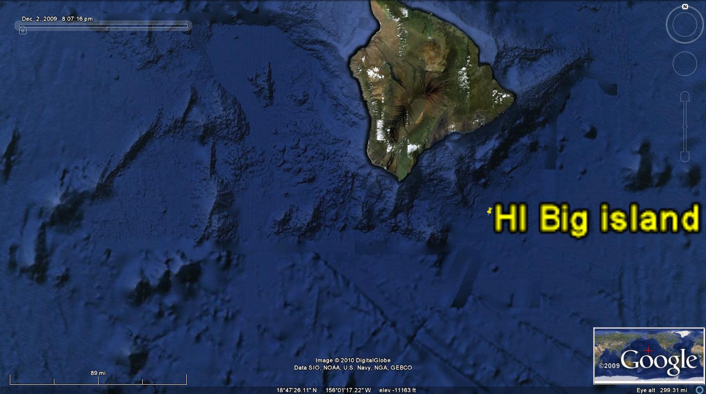
HOWEVER, WHEN A SCAN IS MADE OF THE BIG ISLAND OF HAWAII, ONE CAN SEE- WITHOUT MY ENHANCEMENTS- THE CIRCULAR SHEAR ABOUT RISING KILAUEA AND SINKING (CW) MAUNA KEA. AN APPROXIMATE RATE OF SHEAR IS FOUND FOR THE EXTINCT KEA, WHERE THE SHEAR IN 1 M.Y. HAS NOT COMPLETELY ENCIRCLED THE SINKING EXTRUSIVE MASS. THE INDICATED 68 MM/YEAR RATE OF "RIP" OR TEAR IS LARGE, IN COMPARISON WITH THE TOTAL ISLAND PROGRESSION OF 8.6 CM/YEAR OF THE ISLAND CHAIN MOVEMENT IN THE "APPARENT" N120E DIRECTION.
FURTHER, THE RISING SEAMOUNT- OFF THE SOUTH COAST OF HAWAII- HAS SHEARED- CCW- A PORTION OF A CIRCLE, WITHOUT EVEN RISING TO THE OCEAN SURFACE. THIS PHOTO SHOWS THAT THERE ARE SHEAR LINES IN A RADIAL PATTERN (CALLED RADIAL FAULTS BY SALT DOME GEOLOGISTS-SIMILAR IN MANY RESPECTS TO A RISING VOLCANO: HOT, LOW DENSITY, SHEARING CCW, RISING, AND CREATING PERMEABLE PATHS FOR FLUIDS TO EMERGE).
 Photos above and below show the emerging volcano, which as yet has not reached the ocean surface. IT IS PRESAGED BY OTHER SEAMOUNTS CLOSER TO THE BIG ISLAND OF HAWAII, WHICH EXHIBIT RADIAL FAULTING AND OTHER ROTARY FEATURES:
NOTE: WHEN TWO FAULT MOVEMENTS LIE ON THE SAME PATH, SUCH AS THE WASATCH LINE, THEIR SEPARATION CREATES AN EXTENSION IN THE CRUST AT THE POINT OF DIVERGENCE. INITIALLY, THIS IS AN ACUTE TRIANGLE, AT WHICH BASALT EMERGES; THIS LOCATION OCCURS AT THE HURRICANE CLIFFS EAST OF ANDERSON JUNCTION, AND THERE ARE MANY FLOWS NEARBY. AT THE TIME OF DIVERGENCE, THE TWO PROVINCES WERE AT EQUIVALENT ELEVATIONS, BUT NOW THE B&R IS SINKING AND THE CP IS RISING, SO THAT THE BASALT FLOW APPEARS HIGH ABOVE THE SMALL FARM THERE.

THE PARALLEL TWO-TRACK LINE OF HAWAIIAN VOLCANOES IS DIVERTED TO THE WEST, BY THE OCCURRENCE OF A TRANSFORM AT THE ISLAND OF MAUI- WHERE A TRANSFORM FROM BAJA, MEXICO CREATES A WESTWARD MOVEMENT (SEE THE INDENTATION IN THE MEXICAN COASTLINE, WHICH FORMS A BAY-INDICATING A EASTWARD SHOVE ON THE NORTH SIDE. THE PROTRUSION ON THE SOUTH SIDE INDICATES A WESTWARD LATERAL MOVEMENT ALONG THE TRANSFORM).

Below photo shows the shear lines produced by the side-by-side extrusions on the Big Island of Hawaii. These represent the cooling and shrinking Mauna Loa and rising Kilauea, which have been interpreted by some scientists as two-track vulcanism. This is only partially true, since previously there were side-by-side extrusions so long as the rotations of both were near and on opposite sides of the track. Now there is divergence, due to the transform from Baja causing a westward movement, since the formation of Maui. This creates an opening in the crust, which allows a continual out-pouring of basalt lava. This, again, is due to the strike creating the transform’s acceleration of the shear from Baja to Maui. A prediction may be made for Hawaii and its combination of rising and shrinking (dead) vulcanism. There are two extinct volcanoes- Mauna Kea and Loa. These both are rotating CW, due to cooling and shrinking. This creates a conflict at their common border, since this is similar to two gears trying to mesh, while moving at the contact, in opposing directions. This creates enough heat from brittle friction to produce rejuvenation of a small extrusion (not from the original magma, but from shallow depths where the grinding occurs). This is predicted from the portrait of the two ancient volcanoes, to lie on a line or locus of contact, as shown in the following Google photo:


The age of Maui is known- being about 2 m.y. in age, and requires the location of an asteroid which would have accelerated the strain (physical movement along a somewhat linear path).
Now we see the solution to the HI-Emperor chain: it is due to the movement of the NA Quadransphere (under the impetus of the various asteroid strikes since KT) to a N120E direction. Previous directions were determined by the rotations under the influence of the individual strikes (N-S for KT, later for EO at 41 m.y. another at 28, and finally that for the 2.15 m.y. strike). NOTE: these have been measured by radio-dating for the various seamounts and islands, which can be readily seen on Google earth at the major transforms in the North Pacific.
AN ADDED HELP FOR FINDING THE AGES OF ASTEROID STRIKES IS FOUND IN EXTINCTIONS FOUND IN THE FOSSIL RECORD. THIS HAS BEEN RECORDED BELOW, SO THAT AN ESTIMATE OF THE TIME OF A STRIKE (WHICH PRECEDED THE EXTINCTION) MAY BE DETERMINED. ONLY THE MAJOR EXTINCTIONS ARE CORRELATED, SINCE THERE MAY HAVE BEEN MINOR ONES CAUSED BY OTHER CATASTROPHES- SUCH AS MASSIVE VULCANISM, DESSICATION OF THE OCEANS, ICE AGES, AND "IRRATIONAL EVENTS"- SUCH AS THE GREED OF MAN:
there is additional HELP IN FINDING MAJOR ASTEROID STRIKES, BY LOOKING AT THE HISTORY OF THE COLORADO RIVER- WHICH HAS BEEN DIVERTED TO THE SOUTH AT LEAST 3 TIMES. USING THE ASSUMPTION THAT AN ASTEROID STRIKE WILL HAVE AN IMPACT PROPORTIONAL TO ITS DIAMETER (ALTERNATIVELY, TO ITS MEASURED CRATER DIAMETER), WE NOTE THAT THE COLORADO HAS BEEN PROGRESSIVELY MOVED (LESSER SO TO THE WEST WITH TIME, PRESUMABLY AS ASTEROIDS BECOM SMALLER WITH EARTH'S HISTORY) AND DIVERTED IN SIMILAR PATTERNS AS IT TRAVELS OFF THE COLORADO PLATEAU- SHOWN BELOW:

BELOW ARE MEASURED ASTEROID CRATERS, FROM VARIOUS AGES. THESE MAY HELP DETERMINE THE STRIKES WHICH HAVE CREATED THE VARIOUS TRANSFORMS- SUCH AS THAT FOR MAUI- WHICH HAVE CREATED RE-ORIENTATIONS OF THE TRACK OF THE HI-E ISLAND CHAIN: Glikson/Earth and Planetary Science Letters 236 (2005)
Epoch , Age Asteroid Igneous Province
CENOZOIC
PlM border, 5 ma C2. Karakul, Tajikistan (52km) 39 01’N,73 27’E
Miocene, 11 ma C1. Ewing structure, 55 km
mid-Miocene 14.8 Ries, Germany (24 km) 48 53’ N, 10 34’E
Langhian, 15.97 ma. 15.1+-1 ma 16.2+-1 ma. Columb.Plat. Basalt
Eocene-O, Siberia B1. Popigai 35.7ma(100 km) 71 39N,111 1’E
36.9 +-.9 m.y. B2. Chesapeake Bay (85 km)
36 ma E. Mistastin, Canada (28 km 55 53’N,63 18’W
39 ma Haughton (23 km) 75 23’N,89 46’W
40 ma Logancha. Russia (20 65 31’N,95 56’E
50 ma D. Montagnais, Canada (45km) 42 53’N,64 13’W
MESOZOIC
KT 65.5+-.3 A. Chicxulub (170 km) 21.5N 89.5W
64.98+-.05 ma S. India antipode 30.5S 87E Deccan Plateau
Cretaceous Carlswell (39 km) Ontong, Java
93.5+-.8 m.y. 115+-10 m.y. (120 km)A, B. etc.= RELATIVE CRATER SIZE; A = largest in Tertiary
BELOW IS SHOWN THE "BIG ISLAND", WITH ITS 3 MAJOR ROTATIONS: ACTIVE CCW KILAUEA, COOLING MAUNA LOA ROTATING CW, AND EXTINCT MAUNA KEA- WHICH IS ALMOST A MILLION YEARS OF AGE. BETWEEN TWO SIMIARLY-ROTATING SETS, THERE IS BRITTLE FRICTION AFTER A MILLION YEARS. POSSIBLY ONLY HOT SPRINGS HAVE POPPED UP IN THE LOCUS BETWEEN THE TWO ADJACENT PEAKS (IN THE SADDLE BETWEEN THEM), BUT WE WILL SEARCH GOOGLE EARTH, AND IF NECCESARY MAKE A FORAY INTO THAT REGION TO FIND EVIDENCE OF HEAT.

EXPANDING, SO THAT THE DETAILS OF LOCAL CONES MAY BE EXAMINED:

YOUNG CONES ADJACENT TO THE EXTINCT MAUNA KEA ARE SHOWN BELOW- THESE WOULD BE IGNORED BY VULCANOLGISTS, SINCE THEY WOULD BE CATEGORTIZED AS BELONGING TO THE MK MAGMA. NOT SO! SINCE MY ANALYSIS RELATES THAT THEY DERIVE FROM COUNTER-ROTATION OF THE TWO ADJACENT SPIRALING AND COOLING MOUNTAINS. THEY WOULD BE FORMED BY THE HEAT OF BRITTLE FRICTION OF THE SOLIDIFIED MAGMA- WITH ITS NEIGHBORS, AS IT SPIRALS CW DOWNWARD INTO THE CRUST. BELOW IS A PHOTO TAKEN ON THE SADDLE ROAD AT MILE POST 22, SHOWING A 1000 YEAR OLD BASALT:
 REVIEWING THE GEOGRAPHY OF THE BIG ISLAND:
 AND KEEPING IN MIND THE BORDER OF THE TWO CW-ROTATING MOUNTAINS, ALONG THE SADDLE ROAD- WHICH FORMS A LOCUS OR LINE OF POSSIBLE YOUNG CONES FROM THE HEAT OF FRICTION OF BRITTLE ROCKS (NOT FROM THE ORIGINAL MAGMA, WHICH IS NOW DEAD):
 FINALLY, WE FIND MY "USUAL SUSPECT" OF A YOUNG EXTRUSION- STILL IN THE SHAPE OF A CONE OF ALKALINE BASALT (NOT THEEOLITIC- WHICH IS UN-WEATHERED AND UNAFFECTED BY REACTION WITH THE ELEMENTS OR WITH OCEAN WATER, WHICH WOULD NOT OCCUR WITH AN ORIGINAL DEEP EXTRUSION). THIS IS KOA KIPULA:
Armed with this protracted analysis of the Hawaiian vulcanism, we can now re-analyze Sullivan Knoll. Evidently it takes at least 1 m.y. to develop a CW-rotating shear zone about an extinct extrusion. This is the case for Ivins Knoll, where it has preceded the 2nd extrusion (Sullivan) by at least .8 m.y.
There is a scarp on the south west side of the structure, which has puzzled me; it is a scarp increasing in height to the south- near the Sand Hollow Lake east dam.

This scarp must pertain to the original flow from Ivins, and relate to the shrinking and CW-rotating base of Ivins (since it increases in height in the direction of Ivins’ south side, and not in relation to Sullivan).
This Ivins scarp is shear, making it difficult to scale. But on the edge near hiway 9, there is an access road where ancient Virgin gravels outcrop. The general rule is: the higher the basalt elevation, the older the flow; this pertains to this corner of the rotation, and I enclose a photo of the contact of the gravels with the basalt scarp (obviously older also, since they are also much higher than the present Virgin rim):

NOTICE THAT THE WASH ALIGNS WITH THE BREACH IN SULLIVAN KNOLL. THIS CONFIRMS THAT THE NW-SE FRACTURE HAS BEEN SLICING THE UNDERLYING IVINS, AS WELL AS THE YOUNGER SULLIVAN KNOLL. IT CONTINUES, SINCE THE CREEK HAS A TRIBUTARY- INDICATING ANOTHER ANOMALY.

 ABOVE IS THE LOCATION MAP OF THIS EASY-TO-HIKE FORAY INTO THE MARGINS OF SULLIVAN AND IVINS KNOLLS. PARK ACROSS FROM WAL-MART TRAFFIC LIGHT, IN THIS FENCED BUT "FOR SALE" AREA, TO ACCESS OPEN FIELDS AND CANYONS WITH MORE DIFFICULT SLOPES.THE GRAVELS ARE LIMESTONE AND SOME HARD-AS-QUARTZITE SILICATES, INDICATING AN AGE OF PALEOZOIC OR OLDER. THESE ARE THE HIGHEST IN ELEVATION WELL-CEMENTED RIVER GRAVELS I HAVE FOUND NEAR SULLIVAN KNOLL:
NOW WE CAN RE-ASSESS THE SHEAR AND ROTATIONS OF SULLIVAN KNOLL, WHERE THE NW CORNER HAS DRAINAGE ANOMALIES CREATED FROM SHEAR OF THE CRATER ALL THE WAY TO THE EDGE OF THE IVINS BASALT SCARP. NOTICE THE SULLIVAN SHEAR CIRCLES, WHICH CAN BE DISTINGUISHED FROM THE BROADER-REACHING IVINS SCARPS. THE SCARP STRETCHES ALL THE WAY TO THE SOUTH TO THE SAND HOLLOW DAM- INDICATING THAT IT IS A MUCH LARGER FEATURE THAN SULLIVAN KNOLL.

The finding that these conglomerates lie below the basalt flow and above the Mesozoic Jn tells a story of Pre-vulcanism history. They likely came from the east- from the rising Hf drainage, as there are Permian limestones outcropping there now. This indicates that at 1 million years or less, there was a scarp and separation of Pz and Mz rocks. This is in agreement with my previous findings that Hf started rising, again, in Pleistocene time- as dated by the vulcanism in Zion NP.
Drainages near Sullivan Knoll
The NW to W trends of drainages on the NW side of the crater are a new finding. These do not match any of the expected N-S or arcuate traces, but they do indicate parallel arrangements with Gould’s Wash, a faint scarp on the south side of the youngest extrusion, and orthogonality with fractures at Sand Mountain. These are shown on the following Google photo for NW Sullivan knoll:


This finding relates that there were shear patterns NW-SE before vulcanism started. Hf forms N-S linears, Sand Mountain has N60E fractures, and the Virgin anticline orients NE-SW; these do not relate to the drainage displaying Pz conglomerates. Keep in mind the major premise: drainages follow the shear and its movements- which allow more easy erosion. A conglomerate in a linear pattern indicates that there was NW-SE shear BEFORE the vulcanism, and that the creeks followed this pattern. This was on top of Mz sandstones, and I did not find any dominant fractures in the few outcrops of Jn photoed. The NW-SE movement continues, since the breach of Sullivan was post-eruption, and the wash was formed by the weaknesses in the conglomerate- formed by shear in that direction. The canyon walls are steep- a further indication of little erosion since the canyon was cut. Shear patterns are formed by Coriolis rotation, which senses any linear thrust caused by earth tides, asteroids, or vertical movements. I conclude that there exists a fault or fracture pattern which is on-going, but which was in effect before vulcanism was initiated. This is not insignificant, since the conglomerates and their continuity indicate a drainage which persists- indicating an un-catalogued shear and movement. This can explain why I do not find a regularity in the shear rotations surrounding Sullivan Knoll. The outstanding question remains: WHAT HAS CAUSED THE NW-SE DRAINAGES AND SHEAR INDICATIONS? There is one hint not previously mentioned: there is a tilt to the conglomerates- down toward Sullivan Knoll. This could be related to the sinking of Sullivan knoll as it cools, causing a tilting of the surrounding Ivins (older) basalts. Ivins would have sunk and re-adjusted long ago, and now be influenced by the younger Sullivan sinking.

ALL OF THIS DEMONSTRATES THAT I HAVE FOUND AN ANOMALY WHICH PERTAINS TO THE LATEST RISE OF Hf- WHICH IS YOUNGER THAN 1 MILLION YEARS. THE DRAINGAE IS YOUNGER, BUT PART OF AN ON-GOING MOVEMENT WHICH HAS BREACHED SULLIVAN KNOLL, LAID BARE GRAVELS FROM EAST OF Hf, AND SLICED THE BASALTS LYING ABOVE THE CONGLOMERATE. THIS WILL HAVE TO BE TREATED IN A SUBSEQUENT SUBMISSION ABOUT Hf (AN ANALYST'S WORK IS NEVER DONE- THE EARTH IS MOVING FASTER THAN ONE MAN CAN FOLLOW IT!):
 PROCEEDING INTO THE CANYON WITH THE ANOMALOUS DRAINAGE, THERE OCCURS A TRIBUTARY. NOTICE THAT THE GRAVELS ARE LIGHT-COLORED (INDICATING CARBONATES AND SILICATES- BUT NOT BASALTS), AND THAT THERE IS A SLIGHT CHANGE OF DIP OF THE CONGLOMERATE AT THE JUNCTION OF THE CREEKS (EVERY JUNCTION LOCATES A GEOLOGICAL ANOMALY OF SOME SORT):
THE SOLUTION TO THE ANOMALOUS NW-SE SHEAR LINES IS FOUND IN THE ANALYSIS OF 3 SEPARATE FLOWS, 2 OF WHICH ARE OLDER THAN THE PROMINENCE NOW DISPLAYED (SULLIVAN). WE'LL SAVE THIS FOR A SEPARATE BLOG, BUT FOR NOW, THERE ARE SHEAR CIRCLES WHICH HAVE BEEN INTERDICTED BY THE YOUNGEST, AND WHICH WERE DETERMINED BY THE STRESSES PRODUCING THE NW-SE PARALLEL SHEAR LINES:
