Sand, sand everywhere, and all the land does Quake-
The ancient dunes they tremble , and every grain can Shake!
Shifting, drifting- one is Biblically Hailed-
Tumbling along quickly, and upon white thorns Impaled; Life is dusty, life is Hard-
Life is gritty and my days soon do Retard!
All day I face the barren Waste-
There is no sweat- there's only Paste
Upon my brow, upon my horse and Skin
The desert ne'er relents- and there is flinty dust Within!
I fantasize of cleaner climes, and I'll go there when I Can-
But instead of Nature's dust o'er there, one finds the grime of Man!
Harold L. Overton
SUMMARY: volcanoes.usgs.gov
Pagan and the Aleutian chain extrusions are the North American Volcanoes of note. Pagan is in the Marianas chain (including Guam- where I resided for 2 years), and it is NOT in the main Arc of tho se from Iwo Jima to Tokyo! Assessment wil follow for the next Full Moon!
earthquake.usgs.gov will show that there is Maximum in the Quake Magnitude plot versus time (Date) at the Full Moon- indicating that the assessment of its "stretching" of the Crust (creating Microcracks) is correct, excluding Anomalous Quakes- such as the Solomon Islands of 18 November (possibly due to CME- Coronal MASS Ejections), and not followed by me! MASS is the KEY (seen 2D).
Finally, follow: landslides.usgs.gov for other Vertical movements- which are at a Maximum during the Full Moon!


10,000 km Distant are the Bonins- where a Seamount is found:

Choosing the one which fits the 10 Kkm and Location:

Pink is the line from the best located Seamount:


Vulcanism and EARTH TIDES
"Recent" VOLCANOES are Not exhausted; they are ACTIVE in Central and South America- on to Indonesia's Ruang and Sinabung! Mainly, they occur at a CONVEX Coast (Indonesian Archipelago and Central America); but what about Chile-where the country has almost N-South coastline? Andes next?
Aleutians are Convex to the South, and the Pacific is SHRINKING overall! Chile has MANY CONVEX ARCS, and the ones pointing to the West can be expected to exhibit VULCANISM!
Volcanoes can originate in shallow Depths- such as HIGH PRESSURE mud flows- e.g. Mississippi River mouth, where UNCOMPACTED Sediments seal the Pressure- until they are penetrated by a Drill! Blowouts then occur-with the Fluids (warm or ambient T) exiting until the Pressure is relieved. Photo shows the East Java Lusi MUD FLOW displacing People and rice fields!
Shallow Andesitic Vulcanism (from the Crust) occurs as Blasts of Ash and Cinders- by recycling Heated sediments such that what was Rock becomes Fluid! Quakes are associated with all of these, and the Separation may be a Quarter of the Earth's Circumference (90 degrees, or 10,000 km), and we Wonder about the Magnitude of the Associatedearthquake.usgs.gov (6.4M is the border- so far- between Seamounts and VOLCANOES!). Cases are shown for Volcanoes in the Americas and Java- which I have experienced, and we will develop a way to find PREDICTABILITY?


South of the Equator, at the Kelud Volcano (erupted 1919AD), measure 10Kkm to the Equator:


Since Veus and Earth are "Locked" in a 13/8= 1.625 Orbital relation, Earth exhibits the RATIO in the Diameters of the 2 Orbs in an Analemma (Figure 8, as in OlO sideways). The two Orbs are formed by the Moon/Sun = 2.16, approximately, and we must determine how Venus "got into the act"! Our SUN creates E-West Transforms (see Mendocino reference at 40.439N latitude), and the Moon expands our crust in a N-S direction (sort this out with the Cascades, from Mt. Lassen to Olympus, for a 7.2 degrees Latitude change= 800 km, from South to North).
A CLUE is found from the Tropics' Latitude (23.439 degrees), which is 17 degrees south of Mendocino,CA. Can Pluto, with its 17+ degrees Inclination, be in the act also? Another clue is found with Chile's 2400 km coastline- but the Compass angle is not N-S (180 degrees, but 187- according to where the linear is started). This hints at Mercury, with its 7+ degrees Inclination, altogether indicating that all of the Planets are Gravitationally influencing what Geologists call SUBDUCTION!
This analysis can start with the observation that there are NO large transforms north of Mendocino- indicating that the Division between our Sun's Influence wanes north of that Latitude. South of this, the USA Orb expands 1 mm/year (as do South America and Australia)- found by dividing the Maximum Diameter, E-W, by the years since Moon Capture (4300 million years). Involved so far, are the Tropic (Sun), N-S movement (Moon), Divider (diagonal, by Venus), and the 2 inner and outermost planets!
Peru's Iberia 7.6M quake on 24 November/2015 (depth 606.6 km)is exhibited for comparison:

BIG PICTURE, for the 20,000 km total (half the Earth circumference) separation:


The Equator is acting as a DIVIDER of the Shifts and Transform faulting (Maximum Rotational Velocity occurs there, and decreases in both North and South latitudes!

Jarvis Island, west of the Line Islands, is near the Intersection of the Kelud Volcano (Java) and the 7.6M quake in Peru Lines of 10Kkm length (Quarter turn of the 360 degree Earth Circumference- Orthogonal or L relation). The TOTAL 20,000 km is a half turn- so that a Vertical Extrusion for Java would be a Descending Mantle drop, for Peru! This is Reverse to the Mantle Plume assertion, and can be visualized as a Descending slab of Basalt, instigated by the Full Moon's Extension of the Crust and Mantle- allowing the Opposition Planets to attract the oppsite side of the Earth (Sinking on the Peru side)!
Next Eruption will be at Mt. Slamet, Java- which is 10,000 km from the above INTERSECTION! Uncertainty is 10.6 km (East of old Slamet), and this Volcano has erupted in 2009 to 2014! The location is shown in:
 volcanoes.usgs.gov reported on December 1/2015: Pagan on 18.13N 145.8E, an Island, Marianas- a Warning that Ash was being sprayed!
 Pagan is NOT on the main ARC of extrusions- from Iwo Jima to Iceland, and is not expected to yield a 2016 extrusion!
 Rises are shown South of Iwo Jima- similarly South of Tokyo (Fuji?), with AGE of 25.83 m.y.

Here's the Black Hole you always yearned to see (equivalent to the EYE of a Hurricane), which our modern WPA has produced! Clumps you see are not Cataracts, since you see the Crud that surrounds the Lens (Scabs , or Matter- my Mother called it)! Equivalent on Earth, I have photoed in Sand Hollow- as a Circular Spiraling hole in the bottom of a Wash (sliced by a Normal fault, and washed clean- showing that one can "ESCAPE from a BLACK HOLE"!
Northern RISE is younger, moving to the North!
Next Eruption will be at Mt. Slamet, Java- which is 10,000 km from the above INTERSECTION! Uncertainty is 10.6 km (East of old Slamet), and this Volcano has erupted in 2009 to 2014! The location is shown in:


How BIG are BLACK HOLES? Google Earth is a "starting point" where the Scales have been noticed: micron, millimeter, Meter, Km, Megameter, on to 40,000 km- the Circumference of our Earth! So far, I have only advanced to 3: small scale (SS); Large Scale (LS); and Very Large Scale (VLS); these pertain to our Earth, the SOLAR SYSTEM, and SPACE- where the Third category is Rank Speculation! We should work out the Details of Gravitation on Earth, and proceed to our Solar System- before "Wading into the Vast UNKNOWN"!
Our Sun enters the Constellation of Ophiuchus for the next Month! This has nothing to do with OPHIOLITES (pronounced Oaf e Oh Lights), but does introduce us to an un-noticed segment of the Sky! Important to our correlation of EARTHQUAKES is the occasional CME- Coronal Mass Ejection from the SUN (Key feature is MASS), where there was a 7.6M quake off the Solomon Islands on 18 November/2015. This DATE was not either that for the Full or New Moon, and is another Time to be considered in our correlation! Since the Mass of our nearby Planets determines the Magnitude of the Quake, this CME must be incoporated into our analysis! This is a "Bee under our Bonnet", and we are now made Aware!
We have been successful in Correlating the TIMING of Earthquakes with the Full Moon working in concert with the Close Association of Planets which are Opposite to it. That is, Planets are near the 2D position of the Sun (Conjunction), and in Opposition to the Moon. When this occured last month (October/2015), there were significant Quakes of 7.0M or more! November has the Planets dispersed away from the Sun and from each other, and it is expected that only minor quakes will occur on Nov 25/2015. This can be followed on: earthquake.usgs.gov
The expected QUAKE occured November 25/2015, with a 7.6M jolt at Iberia, Peru (10.07S 70.981W)! It occurred on the same day in Terauaca, Brazil (Mistake by USGS) at: 10.0475S 71.023W at 5:50:53 Mountain Time, as a 6n11.7 km Depth Quake:
 LARGER VIEW (Region):
 Since these Transforms are Parallel to the Equator, the SLOWING of the Crust away from it (caused by the friction from our Moon), creates rhese "Jerks" periodically! The Date being the same, the displacement must be caused by the small difference in Time! Look at the Figure 8:
 Mars appears to be the source of the abandoned Meander! This would make the occurrence between the two Quakes to be 1.88 years- even though they occurred at the same time (earlier beginning for the dry Meander)!
3 Quakes occurred in 2 days, in Peru (first) and Brazil- in an almost SE-NW Orientation (parallel to the coast); this establishes a LaGrange TRIANGLE, with error less than 2%:
 Should there be HEAT, it is at the Depth of 600 km, and not noticeable at the surface; however, this introduces the Asteroids and Jupiter as being in the mix!
BIG PICTURE:


Plate Theory: A. Crust under the Pacific Subducts (dives) under the SA Landmass, at an Angle determined by its Velocity;
B. Brittle rock ruptures - producing Vertical slip (horizontal not explained);
C. Plates move generally W-East at SA; and,
D. Plates are subdivided, when the Inexplicable occurs!
Full Moon produced 3 significant Quakes, during 25- 26 November/2015:
Three events near Tarauaca, Brazil establish an Average Orientation S-North, with the oldest at the south. Latest is 6.7M at 9.21S 71.26W longitude- as shown in: earthquake.usgs.gov
These events had a depth near 600 km- which is inside the Mantle, well below the base of the Crust! This depth should exhibit Plasticity of the solids, and Not brittleness, and this is not explained by the Plate theory!
1. N-S orientations relates to the Moon, where my best case explains for the New Madrid Quake of 1811-12, that there was a "rip" to the north- starting at my Arkansas farm and proceeding in 3 "jerks" to the Mississippi River, at New Madrid town.
2. Largest quake of the 3 occurred the day before the Full Moon, and this is explained as the beginning of the Stretch of the Crust- caused by the Moon and Sun attracting in opposite directions (Opposition);
3. Work of shearing is done by the nearby Planets of Jupiter, Mars, and Venus- which are moving adjacent to the Earth's Orbital Plane;
4. "Rip" is shown by placing your hands on a piece of fabric, and Rotating them away from each other- creating a tear between the balls of the hands! "Jerk" is defined by: d{acceleration= d(velocity)/dt}/dt, and,
5. Usual PLATE THEORY explanation is shown in the comments.
Ambon, Indonesia 6.9M quake of 9/Dec/2015 is associated with a Volcanic Island in the South Pacific as shown:

 BIG PICTURE:

Phobos- Mars' Largest Moon- is descending 1.8 cm/year into the Planet:
Included below are Data for Phobos, provided by NASA:
1. Synchronous with Mars, Inclination 1.1 degrees from its Orbital Plane;
2. Orbit= 7 hours, 39 minutes= .32 days; Retro to Mars- rises in West;
3. Mass= 10.6exp15 kg, 5989 km above Mars surface, has large Voids;
4. and Sink Stickney, on Long end, has 9.07 to 9.5 km Diameter, with Meridians (expansion strains) oriented away from it! Eccentricity= .015 (Ellipsoid).
Analyzing, the SINK is Not a Strike Crater, but a Gravitational Depressson- formed by attraction of the Opposite end by Mars, or by an asteroid. Meridians are formed by expansion of the orb, as it accelerates upon closer approach to Mars (faster rotation expands the centrifugal bulge)!
Comparing with Earth, the Arctic depression is shrinking, and Phobos Sink is expanding (opposite, with Earth's Moon moving away 3.8 cm/year)! Both exhibit Meridians- Earth having the Prime Natural Meridian- PNM- at 169.6W longitude, near the Diomede Islands.
You might ask: "How does the persistent mass at the Antarctic compare with the Phobos end- which is opposite to the Sink?" Answer to this is NOT SOLVED, but a possible solution is that our Moon exhibits a N-S influence- with its maximum Libration of 28+ degrees and the Galactic Plane tilt of near 60 degrees yielding an orthogonal relation, such that Antarctica is expanding (similarly to Phobos' far end)!
Antarctica is indeed Expanding, as is shown by the Spiraling of the Arc toward Tierra del Fuego; Arctic is shrinking, as seen by land encroaching North of the Arctic Circle. Our Sun does NOT directly attract above the circle, as does the Moon!
Fires from VULCANISM can be viewed at:volcano.usgs.gov and the NEXT ONE predicted by my NEW MOON METHOD is for Java (my ol' Stomping Ground), at Slamet, Indonesia- near Tjirebon, Central Jave (Djawa Tengah)!
Slamet is the Vertical EXTRUSION associated with the Full Moon Quake in Peru last November/24/2015. Four hours of work are needed to make the Prediction- using Google Earth and quarter to HALF TURNS (10,000 km- Half Circumference) , to find the Location necessary! Expecting the TIME (Date ) to be in December, watch for a full Year- because of the UNKNOWN UNCERTAINTY! porogle.blogspot.com
EarthSky photo shows the Milky Way, MW, as a Vertical arrangement of Stars in our Galaxy. Andromeda is the only other galaxy you can see with the un-aided Eye, so there is nothing to distort the Galactic Plane! From different Times and Locations, MW will be Tilted away from the Vertical- so, what is the Angle between the Ecliptic and the Galactic Plane? It is near 60 degrees, for easy rememberance (57+, measured by instruments), and our Moon's Maximum Libration angle is 28+, yielding an almost ORTHOGONAL relatio-n or otherwise near 30 degrees! Which is it? Importance of this Angle is shown by the Trial-and- Error result of the Moon's influence is N-S in our NA Quadrant (e.g. Greenland), compared to the Sun's E-W influence at the Mendocino 40.439N latitude!
Our Sun enters the Constellation of Ophiuchus for the next Month (december 2015)! This has nothing to do with OPHIOLITES (pronounced Oaf e Oh Lights), but does introduce us to an un-noticed segment of the Sky! Important to our correlation of EARTHQUAKES is the occasional CME- Coronal Mass Ejection from the SUN (Key feature is MASS), where there was a 7.6M quake off the Solomon Islands on 18 November/2015. This DATE was not either that for the Full or New Moon, and is another Time to be considered in our correlation! Since the Mass of our nearby Planets determines the Magnitude of the Quake, this CME must be incoporated into our analysis! This is a "Bee under our Bonnet", and we are now made Aware!
porogle.blogspot.com
earthquake.usgs.gov
volcanoes.usgs.gov
Preceding 2 months, of October to November/2015, has shown good results- predicting Quakes, using the Moon phases and the Close Combination of two or more NEARBY PLANETS!
Our Moon yields attraction, in combination with the Sun- during the FULL MOON- resulting in MICROCRACKS in the Earth's Crust, which, with Planets' MASSES- creates Lateral Transform faults (Slippage in "Jerks" yields Quakes)! New MOON results in extra attraction- to form SINKS (Valleys, sinkholes, and depressions) on the Opposite side of Earth from the Sun! New Moon occurs 11 December/2015; look for Vertical movements then (90 degrees from Lateral, ORTHOGONAL). Follow:
earthquake.usgs.gov and volcanoes.usgs.gov
landslides.usgs.gov
December has the New Moon on the 11th, and the Full MOON on the 24th- when we will find Lateral to Vertical movements on Earth (Scarps to Volcanoes); watchvolcanoes.usgs.gov
Lateral movements are Perpendicular to Vertical- such as Volcanoes and Downward descending Mantle Fluids: earthquake.usgs.gov
Keep in mind that all this is seen in 2D, where our Moon and Jupiter are widely separated in Distance- but add their individual ATTRACTIONS, when they are aligned! Consequently, the Risks of Quakes and Volcanoes INCREASES when their influences are added!
volcanoes.usgs.gov
Vertical movements are monitored:landslides.usgs.gov
Monitor all these as the Moon progresses from NEW to FULL!
Yesterday, there occurred a minor ashfall and eruption at Momotombo, Nicaragua at 12.422N 86.54W which will be mapped by USGS! Follow this untll the FULL MOON!
Venus is an ENIGMA, with its Retrograde Rotation (CW- not Orbit- which revolves CCW around our Sun)! Venus has: the HOTTEST and most ACIDIC Atmosphere; a Lack of Moons; the Closest position to Earth- but CONTRASTING in most mearureable features; and it is "Locked-in" with us in a 13/8= 1.625 Ratio.
Considering all this, I CONJECTURE that:
1. 1024 million years AGO, there was a CLOSE PASS by Earth- creating:
2. the GREAT UNCONFORMITY (found in the Grand Canyon atop older PC!). Consult the Literature to confirm this age.
3. Rocking of the Moon followed (Libration from 18+ to 28+ degrees- 2x 5.145 inclination angle), and has continued with a descending scale;
4. "Stripping" of the Earth's Crust was NOT COMPLETE- there being remnants older than 1.024 billion years;
5. Mass was slung into Space- some of which Struck Venus, and Reversed its Rotation (becoming RETROGRADE);
6. Earth- beig more massive- dominates Venus, and creates HEAT of FRICTION, and acidification of the Sulfates; and
7. "Locking" produces (in coordination with other nearby Planets- such as Jupiter) VULCANISM on a 10,000 km, and CRATONS on a 16,000 km Triangular arrangement!


3 Quakes occurred in 2 days, in Peru (first) and Brazil- in an almost SE-NW Orientation (parallel to the coast); this establishes a LaGrange TRIANGLE, with error less than 2%:

BIG PICTURE:

Quake 7.6 in Peru to Tropic of Capricorn:

Above 2000 km (fifth of a Quarter) indicates that the Sun- on the Ecliptic, yielding the TILT of the Earth- is involved!
Marianas' Pagan Volcano is active- spewing ash, and expected to Erupt:

Google photo of the 10,000 km line connecting Pagan and the Tropic of Cancer, in the North Atlantic:

Off-Red line, above, connects Pagan and the Tropic of Cancer, TOC! Again, this represents the furthest North movement of the Sun- hinting that our Sun is the dominant factor (Moon should dominate above the Arctic Circle, since the Sun does NOT ATTRACT OVERHEAD above that Latitude!)-10Kkm line from Pagan does NOT show significant anomalies! Try Iwo Jima- which is ACTIVE:

SCAN over the 10Kkm Line:

There are significant ANOMALIES (Notice the volcanic islands to the North):

Lighter sea bed is a RISE, above which the Volcanoes protrude! Curvature, if continued, would exhibit Mt. Fuji. Small end is the Younger rise, and Fuji is still active- killing hikers last year!

Likely NEXT EXTRUSION at Iceland:

The Indian Ocean experienced a 7.1M quake on 4 Dec/2015:

DETAILS of the Transform offshore Chile INTERSECTION:
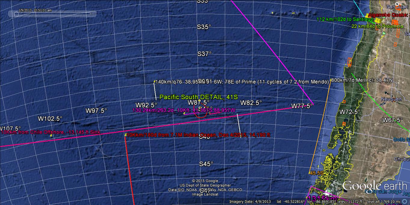
10,000 km x sine(60)/10.24 = 845.738 m.y. is the Maximum Age of the Transform system! This is Pc, and younger is the 80 m.y. Solar Cycle?
December 7/2015, there was a 7.2M quake at Tadjikistan 38.258N 72.767E:

10Kkm from above leads to the Tropic of Cancer, near Tanjuska 10 Kkm connection:

First TRIAL in Pink yielded No Volcano,(Transforms only) and the ToC above is more likely!

Our Moon is approaching a "lineup" with our Sun (New Moon on 11 Dec/2015), and for now- 5 Dec- it is aligned with Venus (our closest Planet Neighbor). In 2D, this means that 2 Solar Masses are Attracting Earth (called Conjunction with Earth)- creating UPLIFT while Shearing, relative to our Sun. Consequently, we are experiencing Vulcanism (Nicaragua's Momotombo and Sicily's Mt. Etna) and Shearing along Transform Faults- to a minor degree! Measurement along Google Earth for a Quarter Turn (90 degrees of 360 for the entire earth= 9/36, or 1/4) finds that these 2 volcanoes are separated by 10,000+ km, and if it were exactly 10 Kkm, this would indicate that the 2 were both Vertical and NOT Orthogonal! A small scarp 167 km from Momotombo (1.67%) indicates orthogonality exists at a straight-line portion of a River in Nicaragua (an adjacent Scarp).
These 2 volcanoes are minor- mainly ashfall and belching Fire- but this should INTENSIFY in the days ahead, to the Full Moon!
Conclusion: Diagonal SHEARING is produced by the Adjacent Orbit of Jupiter and nearby Planets- in Conjunction with the LaGrange positioning of an Asteroid, creating HEAT of Vulcanism!These 2 volcanoes are minor- mainly ashfall and belching Fire- but this should INTENSIFY in the days ahead, to the Full Moon!
Plate Theory: A. Crust under the Pacific Subducts (dives) under the SA Landmass, at an Angle determined by its Velocity;
B. Brittle rock ruptures - producing Vertical slip (horizontal not explained);
C. Plates move generally W-East at SA; and,
D. Plates are subdivided, when the Inexplicable occurs!
Full Moon produced 3 significant Quakes, during 25- 26 November/2015:
Three events near Tarauaca, Brazil establish an Average Orientation S-North, with the oldest at the south. Latest is 6.7M at 9.21S 71.26W longitude- as shown in: earthquake.usgs.gov
These events had a depth near 600 km- which is inside the Mantle, well below the base of the Crust! This depth should exhibit Plasticity of the solids, and Not brittleness, and this is not explained by the Plate theory!
1. N-S orientations relates to the Moon, where my best case explains for the New Madrid Quake of 1811-12, that there was a "rip" to the north- starting at my Arkansas farm and proceeding in 3 "jerks" to the Mississippi River, at New Madrid town.
2. Largest quake of the 3 occurred the day before the Full Moon, and this is explained as the beginning of the Stretch of the Crust- caused by the Moon and Sun attracting in opposite directions (Opposition);
3. Work of shearing is done by the nearby Planets of Jupiter, Mars, and Venus- which are moving adjacent to the Earth's Orbital Plane;
4. "Rip" is shown by placing your hands on a piece of fabric, and Rotating them away from each other- creating a tear between the balls of the hands! "Jerk" is defined by: d{acceleration= d(velocity)/dt}/dt, and,
5. Usual PLATE THEORY explanation is shown in the comments.
Ambon, Indonesia 6.9M quake of 9/Dec/2015 is associated with a Volcanic Island in the South Pacific as shown:

December 9/2015; 10:21:50 UTC there occurred a 7.9M quake South of Ambon, Molokus, Indonesia! These Ambonese people are similar to the "Jolly Hawaiians", and assumed to be precedessors. The closest I got to this region was in Kalimantan (Borneo), but have flown near there from Darwin, Australia.
Ambon is South of the Equator,and we will search 10,000 km along the latitude to find a Volcano- which is ORTHOGONAL to the Lateral Quake. This is a quarter of the Earth's circumference, and likely to be found in the Pacific. A Vertical l, turned 90 degrees, becomes an L, or -. You can Check my work on Google Earth, by measuring the angle to .001 Precision, for 10Kkm distant Location!
How about the relation to the Moon and close associations of Planets? New Moon is on 11 December, and the Jupiter-Venus-Moon association (in 2D) produces SHEAR- which is Adjacent to the Earth's Path! An ASSOCIATED Vulcanism will be found 90 Longitude degrees to the East or West, if the Scarp at Ambon lies along a Latitude line (since this location is nearly on the Equator, where a 111.111 km of Longitude is approximately = a 111.111 km of Latitude.
South Pacific:Ambon is South of the Equator,and we will search 10,000 km along the latitude to find a Volcano- which is ORTHOGONAL to the Lateral Quake. This is a quarter of the Earth's circumference, and likely to be found in the Pacific. A Vertical l, turned 90 degrees, becomes an L, or -. You can Check my work on Google Earth, by measuring the angle to .001 Precision, for 10Kkm distant Location!
How about the relation to the Moon and close associations of Planets? New Moon is on 11 December, and the Jupiter-Venus-Moon association (in 2D) produces SHEAR- which is Adjacent to the Earth's Path! An ASSOCIATED Vulcanism will be found 90 Longitude degrees to the East or West, if the Scarp at Ambon lies along a Latitude line (since this location is nearly on the Equator, where a 111.111 km of Longitude is approximately = a 111.111 km of Latitude.


Phobos- Mars' Largest Moon- is descending 1.8 cm/year into the Planet:
Included below are Data for Phobos, provided by NASA:
1. Synchronous with Mars, Inclination 1.1 degrees from its Orbital Plane;
2. Orbit= 7 hours, 39 minutes= .32 days; Retro to Mars- rises in West;
3. Mass= 10.6exp15 kg, 5989 km above Mars surface, has large Voids;
4. and Sink Stickney, on Long end, has 9.07 to 9.5 km Diameter, with Meridians (expansion strains) oriented away from it! Eccentricity= .015 (Ellipsoid).
Analyzing, the SINK is Not a Strike Crater, but a Gravitational Depressson- formed by attraction of the Opposite end by Mars, or by an asteroid. Meridians are formed by expansion of the orb, as it accelerates upon closer approach to Mars (faster rotation expands the centrifugal bulge)!
Comparing with Earth, the Arctic depression is shrinking, and Phobos Sink is expanding (opposite, with Earth's Moon moving away 3.8 cm/year)! Both exhibit Meridians- Earth having the Prime Natural Meridian- PNM- at 169.6W longitude, near the Diomede Islands.
You might ask: "How does the persistent mass at the Antarctic compare with the Phobos end- which is opposite to the Sink?" Answer to this is NOT SOLVED, but a possible solution is that our Moon exhibits a N-S influence- with its maximum Libration of 28+ degrees and the Galactic Plane tilt of near 60 degrees yielding an orthogonal relation, such that Antarctica is expanding (similarly to Phobos' far end)!
Antarctica is indeed Expanding, as is shown by the Spiraling of the Arc toward Tierra del Fuego; Arctic is shrinking, as seen by land encroaching North of the Arctic Circle. Our Sun does NOT directly attract above the circle, as does the Moon!
Fires from VULCANISM can be viewed at:volcano.usgs.gov and the NEXT ONE predicted by my NEW MOON METHOD is for Java (my ol' Stomping Ground), at Slamet, Indonesia- near Tjirebon, Central Jave (Djawa Tengah)!
Slamet is the Vertical EXTRUSION associated with the Full Moon Quake in Peru last November/24/2015. Four hours of work are needed to make the Prediction- using Google Earth and quarter to HALF TURNS (10,000 km- Half Circumference) , to find the Location necessary! Expecting the TIME (Date ) to be in December, watch for a full Year- because of the UNKNOWN UNCERTAINTY! porogle.blogspot.com
EarthSky photo shows the Milky Way, MW, as a Vertical arrangement of Stars in our Galaxy. Andromeda is the only other galaxy you can see with the un-aided Eye, so there is nothing to distort the Galactic Plane! From different Times and Locations, MW will be Tilted away from the Vertical- so, what is the Angle between the Ecliptic and the Galactic Plane? It is near 60 degrees, for easy rememberance (57+, measured by instruments), and our Moon's Maximum Libration angle is 28+, yielding an almost ORTHOGONAL relatio-n or otherwise near 30 degrees! Which is it? Importance of this Angle is shown by the Trial-and- Error result of the Moon's influence is N-S in our NA Quadrant (e.g. Greenland), compared to the Sun's E-W influence at the Mendocino 40.439N latitude!
Our Sun enters the Constellation of Ophiuchus for the next Month (december 2015)! This has nothing to do with OPHIOLITES (pronounced Oaf e Oh Lights), but does introduce us to an un-noticed segment of the Sky! Important to our correlation of EARTHQUAKES is the occasional CME- Coronal Mass Ejection from the SUN (Key feature is MASS), where there was a 7.6M quake off the Solomon Islands on 18 November/2015. This DATE was not either that for the Full or New Moon, and is another Time to be considered in our correlation! Since the Mass of our nearby Planets determines the Magnitude of the Quake, this CME must be incoporated into our analysis! This is a "Bee under our Bonnet", and we are now made Aware!
porogle.blogspot.com
earthquake.usgs.gov
volcanoes.usgs.gov
Preceding 2 months, of October to November/2015, has shown good results- predicting Quakes, using the Moon phases and the Close Combination of two or more NEARBY PLANETS!
Our Moon yields attraction, in combination with the Sun- during the FULL MOON- resulting in MICROCRACKS in the Earth's Crust, which, with Planets' MASSES- creates Lateral Transform faults (Slippage in "Jerks" yields Quakes)! New MOON results in extra attraction- to form SINKS (Valleys, sinkholes, and depressions) on the Opposite side of Earth from the Sun! New Moon occurs 11 December/2015; look for Vertical movements then (90 degrees from Lateral, ORTHOGONAL). Follow:
earthquake.usgs.gov and volcanoes.usgs.gov
landslides.usgs.gov
December has the New Moon on the 11th, and the Full MOON on the 24th- when we will find Lateral to Vertical movements on Earth (Scarps to Volcanoes); watchvolcanoes.usgs.gov
Lateral movements are Perpendicular to Vertical- such as Volcanoes and Downward descending Mantle Fluids: earthquake.usgs.gov
Keep in mind that all this is seen in 2D, where our Moon and Jupiter are widely separated in Distance- but add their individual ATTRACTIONS, when they are aligned! Consequently, the Risks of Quakes and Volcanoes INCREASES when their influences are added!
volcanoes.usgs.gov
Vertical movements are monitored:landslides.usgs.gov
Monitor all these as the Moon progresses from NEW to FULL!
Yesterday, there occurred a minor ashfall and eruption at Momotombo, Nicaragua at 12.422N 86.54W which will be mapped by USGS! Follow this untll the FULL MOON!
Venus is an ENIGMA, with its Retrograde Rotation (CW- not Orbit- which revolves CCW around our Sun)! Venus has: the HOTTEST and most ACIDIC Atmosphere; a Lack of Moons; the Closest position to Earth- but CONTRASTING in most mearureable features; and it is "Locked-in" with us in a 13/8= 1.625 Ratio.
Considering all this, I CONJECTURE that:
1. 1024 million years AGO, there was a CLOSE PASS by Earth- creating:
2. the GREAT UNCONFORMITY (found in the Grand Canyon atop older PC!). Consult the Literature to confirm this age.
3. Rocking of the Moon followed (Libration from 18+ to 28+ degrees- 2x 5.145 inclination angle), and has continued with a descending scale;
4. "Stripping" of the Earth's Crust was NOT COMPLETE- there being remnants older than 1.024 billion years;
5. Mass was slung into Space- some of which Struck Venus, and Reversed its Rotation (becoming RETROGRADE);
6. Earth- beig more massive- dominates Venus, and creates HEAT of FRICTION, and acidification of the Sulfates; and
7. "Locking" produces (in coordination with other nearby Planets- such as Jupiter) VULCANISM on a 10,000 km, and CRATONS on a 16,000 km Triangular arrangement!
Significant QUAKES are those bove 6.5M, in my system, and the December 7/2015 Tajikistan 7.2m is IMPORTANT!
NEW MOON occurs on 11 Dec, and this is in the ADJACENT SHEARING mode- where Movement occurs along a Transform. The PRECISE Compass Direction along the transform- continued for 10,000 km (Quarter of a turn, or 90 degrees/360) should yield a Volcano, since Lateral is ORTHOGONAL to Vertical! Try this on Google Earth!
earthquake.usgs.gov
MONSOON pattern has changed with the current El Nino of 2015! Usual is for Bangla Desh (Bengali) to "get it", but the moisture has swung to the SW- compared to Portland, Oregon- where the usual SW deluge has moved NW! This is an ORTHOGONAL turn (90 degrees), where the Separation is 12,000 km, and NOT antipodal- but in the same Hemisphere! Uncertainty is 1000 km, since Weather Systems are broad.
This, broadly, is a CCW rotation of the weather systems; it involves at least 30% of the 40,000 km Diameter of Earth! Weather involves HEAT, Winds, Pressure changes, and Shifts of all of these, as seen in ATMOSPHERIC TIDES


 We had the Drownings Early in the Canyons of the SW deserts! Damage has moved to the West Coast- with OR and WA getting the Deluge of December 8/2015! Precipitation is increasing; 5 inches in a day produces unmanageable Floods! Virgin River has not flooded yet !
Turkey has many Quakes! Start from the linear Coast near Istanbul, and proceed to Java's Kelud Volcano in Djawa Tengah:
 Java:
Java:
 Scribing backwards to Turkey- near Tuzla, Uncertainty is 32 km- compared to 1.5 at the volcano:


December 17/2015, I showed a 800 km Rotation of Oregon to Washington, USA, where the Base was Mendocino, CA at 40.439N latitude. 800 km over a N-S meridian is 7.2 degrees of Latitude change, and this is the spread of the Cascades- for Mt. Lassen, CA to Mt. Olympus, done by EARTH TIDES!
Cascades and the OR WA coastline orients South to North (youngest), as the ARROWS indicate; how is this done? Moon, Sun, and Venus are the Prime Movers- for N-S, E-W, and Diagonals (Dominantly)!
Geologists trace Features via Mapped Faults, and more easily are the Fracture Lines (Linears) measured in outcrops. Orthogonal Linears are common- but are generally ignored! Erosion follows the Slices made by these tiny Laterals.
Photos show a case on a smaller scale- that of the Laverkin Canyon- on the SW side of the ZION UPLIFT, being a Creek which has followed Fractures on a 1-10 km Scale. Although part of the Colorado Plateau, Cp, there is a BIFURCATION- where 2 creeks follow 2 separate Arcuate fracture Systems! Wider Diameter indicates the Older, so that Ash Creek is Older than Laverkin! Since Ash never cuts Cp- but is Older- the Cp has moved Westward (by Earth Tides), overtaking the older feature! Age of the Spiral of Zion is younger than the 2 million year Hurricane fault- which separates Ash and Laverkin faults! One million year Basalts have been cut and separated by Hf, pinning the Ages of the movements to less than 2 m.y.
Shown in Indonesia OFFSHORE is a 6.9M earthquake, and I have found by TRIAL and ERROR- that those 6.5 or more Violent have an associated Volcano 10,000 km distant (Quarter of Earth's Circumference)- where Damage increases for Both V and the M number!
Volcano Location is found by using the Fracture aligning with the Quake location (see the lineaments to the North), and measuring the Google Earth Compass angle to .001 degrees- with Longitude and Latitude to .000001 degrees. Keep this angle, and record it! Anomaly at 10Kkm may be off-so RESTART at it- noting an associated Fracture or Transform! Many quakes point to Iceland or other known Volcanic areas!M < 6.4 have fractures or Transforms pointing to SEAMOUNTS 10Kkm away!


 Kamchatka, Eastern Russia (a Northern Pacific Ocean Peninsula) had a 7.2M quake Jan 30/2016 at: 54.007N 158.506E Longitude, with 151 km Depth- near Petropavlovsk. Time was: 03:25:10 UTC, for Major Shaking along a 12 sided Polygonal Pattern- showing Major Fractures N-South, and others at 30,45, and 60 degrees from the Meridian! Look at the Opposite side of the North Pole at: 35.993N first- to determine whether there is a Volcano there (90 degrees Latitude change, or 10,000 km Distant)!
Label this Yelizovo Kamchatka 7.2M, with Coordinates: earthquake.usgs.gov
Kamchatka, Eastern Russia (a Northern Pacific Ocean Peninsula) had a 7.2M quake Jan 30/2016 at: 54.007N 158.506E Longitude, with 151 km Depth- near Petropavlovsk. Time was: 03:25:10 UTC, for Major Shaking along a 12 sided Polygonal Pattern- showing Major Fractures N-South, and others at 30,45, and 60 degrees from the Meridian! Look at the Opposite side of the North Pole at: 35.993N first- to determine whether there is a Volcano there (90 degrees Latitude change, or 10,000 km Distant)!
Label this Yelizovo Kamchatka 7.2M, with Coordinates: earthquake.usgs.gov
NEW MOON occurs on 11 Dec, and this is in the ADJACENT SHEARING mode- where Movement occurs along a Transform. The PRECISE Compass Direction along the transform- continued for 10,000 km (Quarter of a turn, or 90 degrees/360) should yield a Volcano, since Lateral is ORTHOGONAL to Vertical! Try this on Google Earth!
earthquake.usgs.gov
MONSOON pattern has changed with the current El Nino of 2015! Usual is for Bangla Desh (Bengali) to "get it", but the moisture has swung to the SW- compared to Portland, Oregon- where the usual SW deluge has moved NW! This is an ORTHOGONAL turn (90 degrees), where the Separation is 12,000 km, and NOT antipodal- but in the same Hemisphere! Uncertainty is 1000 km, since Weather Systems are broad.
This, broadly, is a CCW rotation of the weather systems; it involves at least 30% of the 40,000 km Diameter of Earth! Weather involves HEAT, Winds, Pressure changes, and Shifts of all of these, as seen in ATMOSPHERIC TIDES

India MONSOON:

DETAILS, at Columbia River;

EarthSky presentation of the current El Nino, I am following carefuly- since I lived in the NW and now the SW (both of which are being affected considerably)! This 2 to 7 year Phenomenon has shifted the Precipitation Pattern for both Bangla Desh-India and the desert to the Wet terrain of the USA! This Counter-Clockwise rotation (of both) is separated by 9000 km, and yields new clues about Global Weather changes- as shown in: quadransphere.blogspot.com
Atmospheric TIDES are similar to Earth Tides, in that the RISING low Pressure systems and cells may be easily seen on the weather channels presented on:goes.noaa.gov
LO is seen as Rising clouds, since DAMP AIR is lower in Density than dry air; High pressure exhibits open spaces, and cannot be analyzed with your sight!
NOTE: water has Molecular weight of 18, compared to 29 for 80% nitrogen-dominated air, and addition of water vapor Decreases the weight!
Weather is Globally-connected, and what happens in one part of the Hemisphere is offset somewhere else! Equator is a DIVIDER, since there is No Coriolis at the exact 0 Latitude, but this boundary oscillates with the INTER-TROPICAL FRONT!
Turkey has many Quakes! Start from the linear Coast near Istanbul, and proceed to Java's Kelud Volcano in Djawa Tengah:


Checking for the 10,000 km (on a Side) LaGrange TRIANGLE from Tuzla, Turkey to Kelud Volcano in Java- a Lateral "Jerk" leading to a Vertical Extrusion:

LARGER AREA:

Java TRIANGLE:

Arctic (in pink) to Java:

Java:

Indonesia,
Kelud Volcano, Java:

Kelud Volcano, Java to the Line Islands:

Larger view to the Solomons (4444 km from Kiribati to a Trench):

Testing the 10Kkm Quarter, from Kenmei Seamount (41 m.y. Inflection) to the MAR, shows that the Location occurs at a Prominant part:

Kenmei LOCATION, where the error may be .1 Longitude degrees:

Sahara, Mauritania, has been surveyed by Ground-penetrating Radar- to find subsurface CHANNELS of ancient streams! Grid overlay is assumed to indicate degree Coordinates, and there are mapping boundaries- which can be ignored to find Natural FEATURES. Noticed are Linears (straight-line white entities), especialy those 2 meeting at 45 degree angles- suggesting an OCTAGONAL arrangement.
Further, the contact of the 2 has a Figure 8 surrounding the location. This arrangement is that of many now present at ANOMALIES- such as at the Hurricane Fault (Hf) at the Virgin River, separating Rising Colorado Plateau, Cp, and the Sinking Basin and Range province BaR.
Rising and Sinking of the Earth's CRUST is assumed to be Cyclical, and my calculations so far have indicated that rising is 1 mm/year or less! The Sahara region has been related to Lucy- where she lived in a WET climate (East Africa), before being covered by erosion in a Rising regime, and then Exumed by Uplift with erosion in a 2nd cycle. This indicates that the cycles are no more than 2 million years in duration. Assuming that the average height, now, is 200 meters- for the Sahara- yields .2 km/2 m.y.= tenth km/m.y.= .1 mm/year.
Vertical EARTH TIDES are much less than the Horizontal- since much more Gravitational energy is required to LIFT, compared to Lateral movement! Lateral ET are 10 mm/year or more.
Earth Tides 7.2 degrees of Latitude (800 km) CW cell is shown from Mendocino, CA (40.439N latitude) to Mt. Olympus- which is Rotating Clockwise vs. CCW for the Darrington fault north of Puget Sound (Deception Pass, Whidbey Island ). Divider is the Bitterroots- Idaho border RISE! Salt water Divider (Sink) is Juan de Fuca- where Vancouver Island is moving NE. String lakes- such as Ross Lake- are extending E-W (east of the Cascades)!
Bitterroots will have a MIRROR IMAGE in one of the Pacific TRANSFORMS- since a Rise has an accompanying Offset, west of the N-S coast!
Bitterroots will have a MIRROR IMAGE in one of the Pacific TRANSFORMS- since a Rise has an accompanying Offset, west of the N-S coast!
December 17/2015, I showed a 800 km Rotation of Oregon to Washington, USA, where the Base was Mendocino, CA at 40.439N latitude. 800 km over a N-S meridian is 7.2 degrees of Latitude change, and this is the spread of the Cascades- for Mt. Lassen, CA to Mt. Olympus, done by EARTH TIDES!
Cascades and the OR WA coastline orients South to North (youngest), as the ARROWS indicate; how is this done? Moon, Sun, and Venus are the Prime Movers- for N-S, E-W, and Diagonals (Dominantly)!
Geologists trace Features via Mapped Faults, and more easily are the Fracture Lines (Linears) measured in outcrops. Orthogonal Linears are common- but are generally ignored! Erosion follows the Slices made by these tiny Laterals.
Photos show a case on a smaller scale- that of the Laverkin Canyon- on the SW side of the ZION UPLIFT, being a Creek which has followed Fractures on a 1-10 km Scale. Although part of the Colorado Plateau, Cp, there is a BIFURCATION- where 2 creeks follow 2 separate Arcuate fracture Systems! Wider Diameter indicates the Older, so that Ash Creek is Older than Laverkin! Since Ash never cuts Cp- but is Older- the Cp has moved Westward (by Earth Tides), overtaking the older feature! Age of the Spiral of Zion is younger than the 2 million year Hurricane fault- which separates Ash and Laverkin faults! One million year Basalts have been cut and separated by Hf, pinning the Ages of the movements to less than 2 m.y.
Shown in Indonesia OFFSHORE is a 6.9M earthquake, and I have found by TRIAL and ERROR- that those 6.5 or more Violent have an associated Volcano 10,000 km distant (Quarter of Earth's Circumference)- where Damage increases for Both V and the M number!
Volcano Location is found by using the Fracture aligning with the Quake location (see the lineaments to the North), and measuring the Google Earth Compass angle to .001 degrees- with Longitude and Latitude to .000001 degrees. Keep this angle, and record it! Anomaly at 10Kkm may be off-so RESTART at it- noting an associated Fracture or Transform! Many quakes point to Iceland or other known Volcanic areas!M < 6.4 have fractures or Transforms pointing to SEAMOUNTS 10Kkm away!
Notification: Case of Ashkasham, Afghanistan on 25 Dec/2015 6.3M at 36.5N 71.132E, 126.4 km depth; 19:14:47 UTC

10Kkm to the Atlantic, East of the MAR:

Finding that the linear continues to a location near St. Helena Volcanic Island, RE-WORK to the Reverse:

The Quake has occurred, as CORRECTED:

ENLARGED, to show the possible association with St. Helena:

Separation between the Volcano and the Quake is less than 10 Kkm, (114 km. or 1.14% deviation):

Relating the Santiaguito VOLCANO, Guatemala, to a 10 Kkm search, the Location is shown:
 Kamchatka, Eastern Russia (a Northern Pacific Ocean Peninsula) had a 7.2M quake Jan 30/2016 at: 54.007N 158.506E Longitude, with 151 km Depth- near Petropavlovsk. Time was: 03:25:10 UTC, for Major Shaking along a 12 sided Polygonal Pattern- showing Major Fractures N-South, and others at 30,45, and 60 degrees from the Meridian! Look at the Opposite side of the North Pole at: 35.993N first- to determine whether there is a Volcano there (90 degrees Latitude change, or 10,000 km Distant)!


B. Find a Transform (straight-line Scarp, Range, or Valley), and Measure to .01 degrees, or best Precision;
C. Extend a line along the Scarp- while shrinking the Map (until line is 10Kkm);
D. Find an ANOMALY nearby- Volcano or Seamount- at Exactly 10,000 km; Record the Location and Bearing!
E. REVERSE the trace- to pass through the Original Quake; record new Bearing!
F. Use differing COLORS- to Distinguish the 2 lines. Record ALL data on Paper!
 Hunter Island has an ACTIVE VOLCANO, and there is a Line of volcanic Islands! Wtch for a new ERUPTION near the Termination of the Brown 10 Kkm Line!
India's Imphal 6.7M quake damage and Location on the USGS shake Map are shown in the Photos, and this has been Searched on Google Earth for a Volcano 10,000 km Distant. Hunter Island- in the South Pacific- lies near the Locus, and has Erupted in 1983 (investigated from Vanuatu)! Expect another Volcano along the line of Volcanic Islands! Check Twitter and:
earthquake.usgs.gov
Documented- over an 8 year Period- are the Dynamics of the Earth, mainly from EARTH TIDES! These SUPPLANT the Geological attempt to look down into the Earth- instead of "LOOKING UP" to the Solar System and its various Gravitation-Controlled Masses!
Keep "Looking Up" to discern the Truth of the Universe!


Interesting is the Mean Velocity of the Orbit= 1.022 km/second- which is close to the Binary numbers- 1.024!
arthquake REFERENCE, for now is: Messina, Italy- where a 7.2M at 1908 year killed more than 72,000! This is in the 100 year Cycle from 1811 New Madrid, MO, USA, and the Economic Catastrophe of 2008! Exercise for enthusiasts is to use Google Earth's MEASURING TOOL- to go 10,000 km in the Direction which yields a Violent Volcano (Quarter of earth Circumference, and 90 degree turn- so that Vertical extrusion is rotated Orthogonally- to locate the associated Lateral)!


4
Searching due South to Antarctica, there are Seamouts along the trace:

Seamounts are more like Non-Cratered UPLIFTS, and we will search in other directions:
Tracing 210 degree SW:

Above Location is near the Tonga Trench, a LaGrange 10 Kkm Triangle HEAT PRODUCER, and in the South Pacific! Check due North of the Volcano;

Of the Three 10,000 km Linears, the Tonga Area seems most likely!
Sahara Desert is shown for Comparison:

India Imphal, Manipur 6.7-6.8M quake of 3-4 Jan/2016: 24.834N 93.656E:

Southern Ocean at 10 Kkm:

What is the Focus?

Investigate the Inflection and find recent Vulcanism!
M6.7 quake on 3 Jan/2016, in India is in the Violent Destruction category; having a file of Vulcanism 10,000 km distant for those >6.5, this appears to associate with New Zealand Craters (after finding that Afghanistan quakes are associated with the Tonga Trench).
Google Earth MEASURING TOOL can be used to find the Volcano; plot the Coordinates shown on SHAKE MAP!
A. Enlarge GE, until the Location is at the Greatest Magnification: Start;Google Earth MEASURING TOOL can be used to find the Volcano; plot the Coordinates shown on SHAKE MAP!
B. Find a Transform (straight-line Scarp, Range, or Valley), and Measure to .01 degrees, or best Precision;
C. Extend a line along the Scarp- while shrinking the Map (until line is 10Kkm);
D. Find an ANOMALY nearby- Volcano or Seamount- at Exactly 10,000 km; Record the Location and Bearing!
E. REVERSE the trace- to pass through the Original Quake; record new Bearing!
F. Use differing COLORS- to Distinguish the 2 lines. Record ALL data on Paper!

India's Imphal 6.7M quake damage and Location on the USGS shake Map are shown in the Photos, and this has been Searched on Google Earth for a Volcano 10,000 km Distant. Hunter Island- in the South Pacific- lies near the Locus, and has Erupted in 1983 (investigated from Vanuatu)! Expect another Volcano along the line of Volcanic Islands! Check Twitter and:
earthquake.usgs.gov
Documented- over an 8 year Period- are the Dynamics of the Earth, mainly from EARTH TIDES! These SUPPLANT the Geological attempt to look down into the Earth- instead of "LOOKING UP" to the Solar System and its various Gravitation-Controlled Masses!
Keep "Looking Up" to discern the Truth of the Universe!
January 9/2016 will exhibit Saturn and Venus in CLOSE ALIGNMENT, and a New Moon- according to EarthSky! The Combo will yield the Attraction of Venus (our closest Neighbor- with which we have a "Linked" relation of 13/8= 1.625 Orbital Days), and Saturn (Far away, and secondary)! The NEW MOON is "in Front of" our Sun, and will Augment Sinks, sinkholes, and Valleys on "the OTHER SIDE" of Earth. What's the practical result?
Expect VERTICAL DROP of the landscape- in the form of Snkholes (most likely), in such places where KARST TOPOGRAPHY is known (Florida, Vietnam, Guatemala, and China)! This occurs where there are CONVEX EASTWARD Coastlines, and which have SEMI-DIURNAL TIDES.
Expect VERTICAL DROP of the landscape- in the form of Snkholes (most likely), in such places where KARST TOPOGRAPHY is known (Florida, Vietnam, Guatemala, and China)! This occurs where there are CONVEX EASTWARD Coastlines, and which have SEMI-DIURNAL TIDES.
Moon's various Cycles are presented by EarthSky- allowing you to discern between "Baying", Menstrual and Birth Rhythms, Lunacy, and Cries of the Loon!
Understand LUNATION (Synodic cycle), Libration (Rocking), Tilt of the Moon (6.68 degrees vs Inclination (5.145, where difference of 1.535 degrees yields 6.68). Eccentricity of .0549 (determines the Ratio of diameters), and Perigee (Closest to Earth) vs Apogee= .4055/.3633 x 10exp6 km. Ratio= 1.11616 (fairly close to a Harmonic of 111.111 km Latitudinal Spacing on Earth)!
Interesting is the Mean Velocity of the Orbit= 1.022 km/second- which is close to the Binary numbers- 1.024!
Back to Lunation, or the Cycle of 2 x 8.85 years= 17.7 years- which may relate to Quake Cycles?earthquake.usgs.gov
Ecuador Coast at: .0145N latitude/17 Compass degrees (3.95 km or .036 degrees Latitude Change, is a Straight Line (Linear ), and Equivalent to Volcan Wolf on Isabella Island- with a 3 km Diameter!Both are North of the Geometrically- determined Equator-indicating that the Mass determined Divider has moved to the North, after the Latest Eruption at Isabella! Trough should have moved Northward, also, and further Active Vulcanism to the South should rotate CW- while Rising (Erupting)! Understand LUNATION (Synodic cycle), Libration (Rocking), Tilt of the Moon (6.68 degrees vs Inclination (5.145, where difference of 1.535 degrees yields 6.68). Eccentricity of .0549 (determines the Ratio of diameters), and Perigee (Closest to Earth) vs Apogee= .4055/.3633 x 10exp6 km. Ratio= 1.11616 (fairly close to a Harmonic of 111.111 km Latitudinal Spacing on Earth)!
Interesting is the Mean Velocity of the Orbit= 1.022 km/second- which is close to the Binary numbers- 1.024!
Back to Lunation, or the Cycle of 2 x 8.85 years= 17.7 years- which may relate to Quake Cycles?earthquake.usgs.gov
Experimenting with a Christmas Day (Full Moon)/2015 Quake offshore Chile- a Photo of the Shakemap via USGS is shown! This 6.1M movement near Transforms can be Magnified (by touching the photo- allowing Enlargement), to find the Compass Angle- e.g. N100W, or 260 degrees from true North- which can be Measured on Google Earth to .01 degrees. Enlarge to get between .01 to .02- which gives you Precision to 2 decimal places! This transfer was done by sending a mail to myself; opening until the Shakemap is shown; holding the top ON SWITCH down while tapping the lower Home Switch! Photo is then SAVED in your Photos.
Two Patterns of Fracture-Transforms are shown above; taking the 220 degrees line:

Following the PINK LINE leads to a Seamount near Marion Island:

A Seamount is forming 189 km from Marion, and this is my Imprecision (This is Not Vulcanism, but a Seamount at 6.3M association!)
Indian Ocean 6.3M, Jan I/2016 is South ogf Australia- near the Tasman Ridge:

10,000 km from this Quake is a Seamount at the Mendocino TRANSFORM:

Showing a Parallel track (in Pink) from a more developed Seamount:

Imprecision is 118 km, or 1.18%, above!
"Here it is "- with an Excellent TRANSFORM tracing N-S, for the 6.3M quake published Jan 1/2016 (Dec 31, my time Zone)- so you can use the Rule of 90 degrees of latitude CHANGE, for finding a Seamount or Mountain- if on Land! Hasta Mañana!
After "eating Crow" yesterday, a 6.3M quake occurred today 31 Dec (1 Jan in Australia ), but this is still below my 6.5M threshold- for a "Killer"!
I'll have All the KINKS worked out of this QUAKE PREDICTION tool in 2016! Happy NEW YEAR, and I'll get a new Samsung 6, for better Photos!
I'll have All the KINKS worked out of this QUAKE PREDICTION tool in 2016! Happy NEW YEAR, and I'll get a new Samsung 6, for better Photos!
Moon's various Cycles are presented by EarthSky- allowing you to discern between "Baying", Menstrual and Birth Rhythms, Lunacy, and Cries of the Loon!
Understand LUNATION (Synodic cycle), Libration (Rocking), Tilt of the Moon (6.68 degrees vs Inclination (5.145, where difference of 1.535 degrees yields 6.68). Eccentricity of .0549 (determines the Ratio of diameters), and Perigee (Closest to Earth) vs Apogee= .4055/.3633 x 10exp6 km. Ratio= 1.11616 (fairly close to a Harmonic of 111.111 km Latitudinal Spacing on Earth)!
Interesting is the Mean Velocity of the Prbit= 1.022 km/second- which is close to the Binary numbers- 1.024!
Back to Lunation, or the Cycle of 2 x 8.85 years= 17.7 years- which may relate to Quake Cycles?


1

Above Red Lines are from LaGrange TRIANGLE, and Brown is the Location of the 5.9M quake!

Reference Raoul Island is shown, above, and below is the Anomaly at the 10 Kkm distance:

Right lower Corner records a Quake 2 years earlier!
Quake near New Zealand: 5.8M, 2Jan/2016- will be used to CATEGORIZE types of Earthquakes:
A. Mass Transfer, e.g. Shift from a Crustal segment which has excessive Mass- this case;
B. Shift along TRANSFORMS- which is seen in Ocean Basins, e.g. Pacific;
C. Storms, Ice melting, Wind, and Sea-level Change cause minor quakes, expected to be < 5M; and
D. Vulcanism- which has Lava spread Laterally.
Moon's various Cycles are presented by EarthSky- allowing you to discern between "Baying", Menstrual and Birth Rhythms, Lunacy, and Cries of the Loon!
Understand LUNATION (Synodic cycle), Libration (Rocking), Tilt of the Moon (6.68 degrees vs Inclination (5.145, where difference of 1.535 degrees yields 6.68). Eccentricity of .0549 (determines the Ratio of diameters), and Perigee (Closest to Earth) vs Apogee= .4055/.3633 x 10exp6 km. Ratio= 1.11616 (fairly close to a Harmonic of 111.111 km Latitudinal Spacing on Earth)!Interesting is the Mean Velocity of the Orbit= 1.022 km/second- which is close to the Binary numbers- 1.024!
arthquake REFERENCE, for now is: Messina, Italy- where a 7.2M at 1908 year killed more than 72,000! This is in the 100 year Cycle from 1811 New Madrid, MO, USA, and the Economic Catastrophe of 2008! Exercise for enthusiasts is to use Google Earth's MEASURING TOOL- to go 10,000 km in the Direction which yields a Violent Volcano (Quarter of earth Circumference, and 90 degree turn- so that Vertical extrusion is rotated Orthogonally- to locate the associated Lateral)!
Thursday, Dec 30/2015, Jupiter and our Moon will be in 2D alignment- Opposite to our Sun and Mercury, yielding an Extension (with Microcracks) of Earth! Venus (our Nemesis) will create Shearing- due to its orbit being Adjacent to Earth's Orbital Plane! Expect a Quake > 6.5M to occur on December 30- within one day! Location is unknown, likely Afghanistan, Chile, or Turkey!
Jupiter, with its GRS at 22S latitude:

Talaud Quake of 11 January/2016 had 6.5M in the Sea between Indonesia and Phillipines, above and this can be traced to Mt. Erebus or to Mt. St. Elias- with an error of 2 percent:

Alternative PATHS:

ENLARGED:

Mt. St. Elias:

Erebus is ACTIVE, while St. Elias is not- and is it about to erupt?

Quake of 6.5M (Talaud, Indonesia) occurred 11/Jan/2016, and that is a day off my Predicted 9 January disaster (their time is a day later than mine)! What gives?
Shake Map, by USGS, allows Coordinates to be shown, and I will plot these on Google Earth to measure 10,000 km along a local Transform and by Compass BEARING- to find the associated Volcano! An ongoing Blast could have "Triggered" this Movement along the Transform?
earthquake.usgs.gov
Quake on 11 Jan/2016 was at 3.864S and 126.867E- between Indonesia and the Philippines, offshore, with minimum damage! Time was 16:38:07 UTC- which is on the 10th for my time- so I missed my predicted 6.4M or greater by a day!
Above quake has an associated Volcano at Mt. Erebus, Antarctica (active), or at Mt. St. Elias (inactive), so which is it? Volcanoes are slow to react- but fast to Erupt, when the "Trigger" occurs! This case has no recent history, so that the "Quake comes First!"

10,000 km from the Morocco Al Hoceima 6.1M quake (25 Jan/2016): 35.741N 3.597W is a Chilean Mountain- possibly a spent Volcano:

Reversing- the ERROR is less than 1 percent:


