
SUMMARY: POLYGONS are formed according to the EQUATION (360- X)/X= an INTEGER, where the integer is concomitant with LINEARS-STRAIGHT LINES. These create polygons with sides determined by the simple equation above- e.g. for the integer 14, there are 24 sides, each at ANGLES 15 degrees apart.

Ozymandias II
Behold the Senate, as for the Desert dunes-
It casts a SHADOW on the simple Life below!
“I can propagate all WARS, by appealing to the worst in Man;
What better way to slow the degradation of the Universe?”
And the ensuing COLOSSAL WRECK stretches the desert dunes- which previously were within the span of Man-
Yet far, Oh far away!
Harold L. Overton
Above are exhibited the SAND DUNAL PATTERN at Furnace Creek, Death Valley, CA. Below is a Google Earth VIEW:
Furnace Creek SINK with WARM SPRINGS is shown above, and its connection with the EXTRUSIONS to the west (GUARDIANS of the GATES) are shown below:

Below is an ALMOST-PERFECT ALLUVUAL FAN, of about 1 m.y. AGE:

This FAN is formed by POLAR WOBBLE; as the pole completes a 360 degree wobble throughout a million year CYCLE, it shifts the DRAINAGE from north to south and back again. We will try to solve the number of cycles needed to form the fan, since there are discontinuities in the trace (indicating that multi-cycles are necessary).
Below is a CLASSIC CASE of a POLYGON FORMED by the LINEAR SHEAR along the Virgin River- turning 45 degrees at 2 locations along the river, and forming a Volcano, as the 45 degree turn creates POP-UP of sandstone, similarly to the gravels popping up as you make a SHARP left-hand turn in your auto on a gravel road:
 You should wonder how I have PRODUCED Polygons, when I have been making AGE CALCULATIONS from CURVILINEARS! There occur both on the EARTH'S SURFACE, and they are distinct- the polygons are formed with LINEAR SIDES. Here is a exceedingly well formed ARC-CURVILINEAR at the ALA SPIT, Whidbey Island, WA:

Cape Hatteras has an OLDER ARCUATE COAST; it is so REGULAR, that I haven't found a better one (it is not disturbed by EAST FEATURES, since the coast is moving to the west (shown by the CONVEX ARC pointing to the west):


All this fits with the POLYGONAL EXHIBIT of the greater Basin and Range 24 m.y. ROTATION. Recall that the Pine Valley Laccolith is 22 m.y.of AGE (radiometricly-measured), and it started the general SHEAR-INTRUSION of the region. This JERK in SEGMENTS is displayed in the POLYGON encircling the Great basin, starting at Death Valley and proceeding CW (sinking) through the GREAT SALT LAKE, to the Santa Clara junction:

You should remark that the indication is for a 12-sided POLYGON, whereas the calculations are made for only 5 sides- which define a half figure. I have found that the SW corner is a zone of more rapid and erratic change, encompassing at least 3 segments, and I have not incorporated it. This includes Death Valley, where the MOST OBVIOUS SHEAR OCCURS (even the shear of an extrusive NOW half volcano):

The CALCULATED ROTATION RATE is 2.4 degrees/m.y., assuming that DV has been forming for 24 m.y. This is checked with the Great Slave Lake, which lies due north of DV:

The TRIANGULAR Lake is a dead giveaway, that there are 3 features junctioning at this location; these include the Great Bear Lake- which is indicated to be a BORDERING LINEAR EXPANDING REGION (NE-SW, entending NW-SE at its NW coastline):

The RAVEN, COURTESY of the ARTIST, Martha:

Once upon a MIDNIGHT dreary, as I pondered weak and weary,
Over many a quaint and curious VOLUME of forgotten LORE,
While I nodded, nearly napping,
Suddenly there came a tapping, as of someome gently rapping-
rapping on my chamber door.
"Tis some visitor" I muttered; "some late visitor, rapping on my chamber door;
Some rare visitor rapping on my chamber door-
Only this and nothing more"
And the RAVEN, never flitting, still is sitting, still is SITTING,
On the pallid bust of Pallas, just above my chamber door.
And his eyes have all the SEEMING of a demon's that is DREAMING,
And the lamplight o'er him STREAMING throws his shadow on the floor;
And my soul from out that shadow that lies floating on the floor,
Shall be lifted NEVERMORE!
Nomenclature may be found in the following insertion:

Above and below NASA photos relate to the UNUSUAL STORM, in the NE USA- named NEMO, occurring 7-9 Feb/20013; this CATASTROPHE was a 100 year or more EVENT. I use this portrayal for nomenclature:

I am posting PREVIOUS BLOGS to show the progression of my FINDINGS, AWAY from a belief that THE GEOLOGY CULTURE had something to offer besides NOMENCLATURE:


Death Valley is an impingement between the Sierras-Central Valley and the Basin and Range cells.
The following photo maps the position of Death Valley between the CA vertically and horizontally-rotating elliptical cell and the Basin and Range region (which is also vertically and horizontally rotating within the Crust):

ENLARGING,

This is a three-dimensional geometrical arrangement, involving the Coriolis rotation. This is a tough one! Not only do we have the diagonal-ellipse of the Sierras-Central Valley rotating two ways (3D- horizontally and vertically), but we have the B and R impinging on both at Death Valley- creating a two dominant fault system (diagonal to each other) within the National Park. This is taken of a region of the Crust, horizontally, within the three states of CA, NV, and UT showing two cells rotating, vertically and separately, for NV (B and R) and CA (Sierras uplifting). Look at the photo I made of a fault tracing N-S in the DV basin, and notice that it has not only created vulcanism by the shear of the general area, but the shear has continued- to produce a N-S fault through the extrusion created by the HEAT from the process:

THE ORIENTATION OF The AMARGOSAS AND THE PANAMINT MOUNTAINS YIELDS CLUES TO THE LARGER MOVEMENTS OF THE REGION:

Second analysis of Death Valley, with trip in Dec 26/2010: My intent is to replace the previous model and Diagram of DV and the Armargosa Mountains. This area is critical for understanding the inter-connection of the B and R and the Sierras separately-rotating cells. It appears that the Sierras are part of the couplet of the NW USA complex- which was formed by the EO revent of 41 m.y. age- and the uplift and rotation of the NW-SE cylinder of CRUST (CA: Garlock fault to Mendocino). It is likely that the Sierras rose in reaction to another EVENT, possibly a fragment of the EO rotation. We have not solved the initiation of linear mountain chains- such as the Sierras- except to note that they form parallel to present coastlines (Owen-Stanley, Appalachian, Atlas, and Andes). My intuition is that they rose due to shrinkage of the Earth (COMPRESSION, by decreasing the separation of Su and Earth), as the globe slows, but there is something causing them to localize near coastlines. It is possible that they rose near oceans, where the crust is thin, but not rigid like basalt in the adjoining oceans. They are composed of lighter sedimentary rocks, which is a hint that density and hardness are major factors. There have been findings of 50 m.y. fossils in the Sierras, so that the EO connection would be negated, favoring the KT strike creating the uplift.

A VIEW OF THE LARGER REGION OF DEATH VALLEY YIELDS INSIGHT INTO THE DYNAMICS OF THE AZ-CA-NV TECTONICS IN THE TERTIARY AND QUATERNARY:

WE CAN SEE THAT ANCIENT RIVERS FLOWED DIFFERENTLY. NOW THE MOJAVE FLOWS TO THE NE TOWARDS DV. IT MAKES ARCUATE PATHS, WHICH ARE DETERMINED BY ROTATION OF MOUNTAINS CCW AND SINKS CW. THIS YIELDS CLUES TO THE PROGRESSION OF MOVEMENTS FROM THE TERTIARY TO NOW:

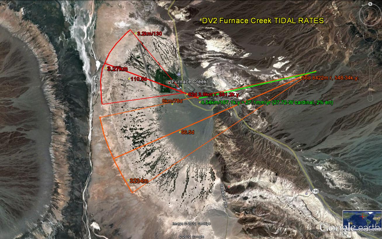
 UPDATING THE DIAGRAM FOR DV, I AM INCORPORATING MOVEMENTS EXPECTED FROM THE INFLUENCE OF THE MANTLE DRAGGING AND UPLIFTING A TILTING MOUNTAIN RANGE BLOCK, AND THE INFLUENCE OF TIDAL SHOVE TO THE WEST-CAUSING CONFLICT IN THE BLACK MOUNTAINS. THIS WILL HAVE TO BE SORTED OUT IN MY FIELD TRIP THIS MONTH (NOTE ALSO THAT I EXPECT THE THERMAL SPRING NEAR FURNACE CREEK TO OCCUR DUE TO THE CONFLICT OF THE BLACK AND AMARGOSA MOUNTAIN ROTATIONS- OF CONTRASTING AGES AND SPIRALING RATES):
THE LARGE VIEW OF THE REGION, INCLUDING THE MIDWAY ISLAND TRANSFORM, INDICATES THAT DV IS GREATLY INFLUENCED BY THE DYNAMICS OF A FAULT AT 28 M.Y. I HAVEN'T FOUND THIS LOCATION, BUT I WILL PROCEED FROM ITS ANTIPODE (WHICH WILL BE AN UPLIFT, RESULTING FROM THE MECHANICAL TRANSMISSION THROUGH THE CORE OF THE EARTH, OF A WAVE). THE CRATER IS MORE DIFFICULT TO FIND, SO THAT WE WILL USE THE RISE:

THERE ARE INDICATIONS THAT THERE ARE TWO RISES INVOLVED IN THE CONTORTIONS OF THE DV SINK AND RISES TO THE EAST AND WEST. BELOW ARE THE AFFILIATED DEPRESSIONS ON THE OPPOSITE SIDE OF THE EARTH, IN THE INDIAN OCEAN, AND WE WILL TRY TO DELINEATE THEM. THEY HAVE DIFFERENCES IN TIME OF UPLIFT, SINCE THE COLORADO RIVER IS KNOWN TO HAVE MADE AN ABRUPT RE-ORIENTATION AT ABOUT 2-3 M.Y. AND THE EAST PACIFIC RISE IS OLDER. THIS PLACES THE OLDER STRIKE AT THE 28 M.Y. AGE- WHICH I HAVE BEEN SEEKING. NOTE THE SOLUTION TO THE PUZZLE BELOW, FROM THE FAINTNESS, OVER-PRINTING, ROTATION OF ONE OVER THE OTHER, AND THE SEPARATION OF THE TWO BY ABOUT 500 KM (DV IS OVER 1000 KM FROM THE EAST PACIFIC RISE):


BELOW WE FIND THAT THE MIDWAY ISLAND 28 M.Y. AGE AND TRANSFORM TO THE GARLOCK FAULT SYSTEM IS A MAJOR CONTRIBUTOR TO THE DYNAMICS OF THE DV REGION. IT IS POSSIBLE THAT THERE IS ANOTHER STRIKE BETWEEN 2 AND 28 M.Y. TRANSFORMS, BUT IT DOESN'T SHOW SIGNIFICANTLY ON THE EAST PACIFIC MAP. OTHER INFORMATION REVEALS THAT THERE SHOULD BE A STRIKE AT EARLY MIOCENE- ABOUT 18 M.Y. AND WE WILL SEARCH FOR IT.


EVIDENTLY THE MIOCENE STRIKE AT THE SUPPOSED DATE OF 18 M.Y. IS NOT SIGNIFICANT ENOUGH TO SHOW ON THE PACIFIC BASIN MAP. I DON'T BELIEVE IT, AND IT MAY OCCUR IN ANOTHER HEMISPHERE (I DON'T BELIEVE THIS EITHER), OR ITS CRATER AND ANTIPODE- CREATING TRANSFORMS BOTH OCCUR IN CONTINENTAL CRUST. WE'LL FERRET THIS OUT IN ANOTHER BLOG SUBMISION, SINCE IT DOESN'T APPEAR TO RELATE TO THE DV ANOMALIES.
THE GOOGLE EARTH VIEW OF THE NORTHEAST PACIFIC INDICATES THAT THE MIDWAY TRANSFORM IS A COMPLEX OF ONE LARGER AND SEVERAL SMALLER SHEAR LINES. PROCEEDING ON THE ASSUMPTION THAT SMALLER STRIKES OF AN AGE LESS THAN THE 28 M.Y. STRIKE HAVE MELDED WITH THE MORE DOMIINANT STRIKE, WE SOLVE SEVERAL PUZZLES WHICH I HAVE NOTED AND SAVED FOR FUTURE DISCOVERIES:
A. MAJOR TRANSFORMS OCCUR EVERY 7 DEGREES OF LATITUDE, INCLUDING THE SOUTH PACIFIC (THIS IS NOT THE CASE WITH OTHER OCEANS- ATLANTIC, ARCTIC, OR INDIAN). THIS SUGGESTS THAT GEOMETRY OF THE SPHERICAL GLOBE IS A MAJOR FACTOR IN DETERMINATION OF THE LOCATION OF A STRESS RELEASE (STRAIN) WHENEVER AN ASTEROID STRIKE OCCURS. IN SHORT, A STRIKE MAY OCCUR ELSEWHERE IN THE NORTHERN HEMISPHERE, BUT ITS SHEARING (LINEAR) APPEARANCE WILL FALL IN A LOCATION WHERE STRESS HAS BUILT UP- BY TIDAL SHOVE, MANTLE DRAG, OR THE REACTION TO ALL THESE BY CORIOLIS FORCE.
B. TRANSFORMS DO NOT NECESSARILY OCCUR AT THE LOCATION OF A STRIKE (ALTHOUGH THE ONE WEST OF MIDWAY BEARS INVESTIGATION).
C. TRANSFORMS RELATE TO THE MAJOR QUADRANSPHERE (THERE MAY BE FIVE) WHERE SOME ASTEROID HAS CREATED A MAJOR INFLUENCE: NORTHWARD FOR THE CASE OF SOUTH AUSTALIA, RIFTING FOR THE CASE OF AFRICA, AND ROTARY FOR SOUTH AMERICA.

THE SOUTH PACIFIC OCEAN TRANSFORM SPACING IS SHOWN BELOW:

BELOW ARE PHOTOS, WHICH I WILL INCORPORATE FROM FIELD DATA, FOR THE NEXT INSERTION:

 GOLDEN CANYON CIRCULAR EXPRESSION, WITH LATERAL SLICKENSIDES, INDICATES A ROTATION WHICH FITS WITH THE FOLLOWING RISES AND SINKS PHOTO (WITH IMPETUS UNKNOWN). I WILL TRY TO SOLVE THIS OBVIOUS CONFLICT IN THE FIELD- WHICH CREATES A SHIFT OF THE REGIONAL FAULTING AND WHICH GENERATES THERMAL ACTIVITY:
 AN EXPANSION OF THE BADWATER SINK AND ADJACENT CIRCLE DRIVE IS SHOWN BELOW:
WE WILL TRY TO SOLVE THE PUZZLES SHOWN
STAY TUNED!