
EARTH’S CRUST is
composed of POLYGONAL, ARCUATE, and TRAPEZOIDAL-shaped blocks- which are separated
by arcuate river valleys, COAST LINES, or LINEARS and MERIDIANAL straight-line
DISCONTINUITIES. These occur on many SCALES: meters at outcrops, km at
geological features, mega-meters (1000 km) at REGIONS, e.g. the Colorado
Plateau, CP, and at 40,000 km- which is the EARTH CIRCUMFERENCE.
Although I have done
the field work in Qsna- the North American QUADRANT, or Quadransphere, I have sufficient
experience in Indonesia, Turkey, and Guam, Marianas to extrapolate with the
ENTIRE GLOBE. I start with South America:
SA progression:

Above is a first TRIAL- it is highly innaccurate (use for pictoral purposes only)! Below, a count of SURROUNDING RISES may be made:

The AMAZON BASIN is surrounded by 12-13 later PROTRUSIONS- which in the east show that the bulge is CORRECT: the CONVEXITY indicates that there has been MOVEMENT to the east, at about 100 m.y.- which shows that the CONTINENT is moving in both directions from the original 4096 m.y. CIRCULAR PORTION! In other words, it is different from Qsna in several ways:

1. It remains farther to the east- on the globe- than NA;
2. Moving to the east forces the CENTRAL AMERICAN ANALEMMA (Costa Rica) to form a PARTIAL FIGURE 8 at the isthmus;

3. Its AGE for the Argentina move south is near 200 m.y., older than the Florida and Mexico "TITS"; and,
4. It has SPAWNED a yet younger set- the S. Georgia, Sandwich Islands- which are VOLCANIC and shown below (58S 30W):


Marianas Islands, including Guam and the Challenger Deep is another of my old "stomping Grounds"- where I was able to RECONNOITER many islands shown in the photo below: Saipan, Truk, Iwo Jima, and Ulithe. These are SEAMOUNTS which rose above the waves:

There
has occurred a DEFINITE CHANGE in the GRAVITATIONAL ACTION after the Great
Unconformity at 1.024 b.y. prior to now. This action resulted in a
great thickness of the STRATIGRAPHIC COLUMN, being removed as shown in the
Grand Canyon. This represents a DISCONTINUITY in the HISTORY of the EARTH, and
resulted in portions of PreCambrian being eliminated (with others- such as the
1.7 b.y. BANDED IRON SEDIMENTARY ROCKS being retained in the SW USA). EROSION
or EJECTION of the column was selective- with ARCUATE REMAINS retained in
low-lying eroded mountain chains.
As shown in the CIRCULAR PORTONS of North
America (the BULGE extending from Cape HATTERAS to the Big Bend of Texas Rio
Grande to Mendocino, CA), the diameter is 4096 km- inferring that while the
continent was REGULARLY RISING, the
circular portion was EXPANDING LATERALLY at a rate of 1 mm/year! EARTH TIDAL
RATES are now 10.24 to 30.72 mm/yr., so that EROSION has offset ELEVATION
INCREASE after 1.024 b.y. AGE.
What happened at this DISCONTINUITY? It appears
that the LATERAL RATE of movement increased, while the ELEVATION RATE has
STABILIZED. Measurements of elevation and TIDAL RATES on “stacked” ELLIPSES of MIMA MOUNDS show that
the UPWARD LIFT reduces the Lateral rate by at least one half!
My experience is that these ENIGMAS are
solved, as CASE HISTORIES are examined; in other words, the FACTS – as shown by
GOOGLE EARTH- always exhibit factors which allow a SOLUTION, so long as one
ignores ASSERTED DOGMA which has been “accepted” by Geologists. We will analyze
South America, which will have no PRE-EXISTING ASSESSMENTS by me (since I have
never been there). We will use the RULES found for North America, to determine
whether they pertain. The first is that E-W MOVEMENTS are 17.48 mm/yr. and
South-pointing CONVEXITIES have 16.24 mm/yr. This has a difference for an arc stretching
cross the Amazon Basin of 1.24 mm/yr. for calculations. Let’s see what happens:
The Moon’s Gravity
began to create vertical and LATERAL BULGES at the time of its capture by the EARTH.
This was 4.096 billion years, b.y., by the BINARY THEOREM- where SIGNIFICIENT
DYNAMIC CHANGES occur at MULTIPLES of 4 (2, INCLUDING more BENIGN events): 1, 4, 16 (Columbia FLOOD BASALTS), 64
(KT extinctions), 256 (PTr great extinction), 1,024 (Grand Canyon great
unconformity), and 4,096 m.y. INITIATION. The PROGRESSION is as follows:
1. The
Moon, in conjunction with the sun, CREATED BULGES on the side facing it, and
bi-monthly at the NEW MOON- on the side pulled by both sun and moon. Between
FULL and NEW, there was LATERAL MOVEMENT as the two bodies pulled at oblique
angles to each other. This cannot be distinguished YET from the GRAVITATIONAL
INFLUENCE of other planets- particularly Jupiter and Venus;
2. Circular
BULGES form INITIALLY, and these are AUGMENTED by “TITS” at their edges as time
passes. Simple EXAMPLES include Tasmania, but Argentina is our closest
neighbor- forming southward from the South America 4,096 km early BULGE. NORMAL TOTAL EXPANSION is 1 mm/year, and this is small compared to lateral expansion because
UPWARD ELEVATION absorbs at least half of the GRAVITATIONAL ENERGY!
SA bulge- which encompasses EARTH'S greatest on-land SINK, the AMAZON:

(above SA exhibit is my first trial, and is greatly in ERROR! Use that shown at the outset!). The previously published AMAZON BASIN reminds me that there are a SERIES of RISES surrounding the basin, and that the one to the SE is a 80 m.y. "TIT" which remains outside of the INITIAL 4096 m.y. ELLIPSE. This will help explain that there has occurred a MOVEMENT to the SE, and that this is SIMILAR to that of Florida and the LATER BAHAMAS PROTRUSIONS.

The
Amazon Basin is the GREATEST Basin in the entire globe; it is surrounded by 12
ARCUATE FEATURES (I have drawn 6 for half of it), and exhibits the usual
ANALEMMA, for a sinking basin- a reverse "S".
Finding a TARGET of OPPORTUNITY at the AZ border- an EXTRUSION shaped similarly to the SA continent- let's use the observation that features are multiplied by a SCALE FACTOR for comparison:

GRAVITATIONALLY-PRODUCED FEATURES can be used to compare CONTRASTING AGES, for determination of a scale factor- in this case 100:1:

The 100:1 factor can be used for the case of Argentina, to determne whether the 300 m.y. age found there is correct; it appears that it should have been 200 m.y. and the OUTCROPS there are of Cretaceous age (100 m.y. or more):

3. This
“TIT” formation continues, and there is a rise to the SE of Tasmania; other examples
include Florida, Madagascar, Formosa, and the southern part of Africa.
 The NORTHERN COAST is ARCUATE, created by SUBSEQUENT ROTATIONS, as time passes (while the ORIGINAL ELLIPSE incurs SINKING,to the NORTH, the south half rises).

SE of the older ISLAND there are RISES in the sea floor- which indicate that a YOUNGER "TIT' is emerging; this will continue INDEFINITELY, so long as GRAVITATION works its VERTICAL+LATERAL MECHANICS:

This occurs on a SMALL SCALE at Sand Mountain, UT, but this is on the SW part of the Hurricane Fault, and indicates that other factors influence the TIT LOCATION (note that SAND MOUNTAIN is a "TIT" between the Hurricane fault, Hf, and EXTRUSIONS near Ft. Pierce wash); and,


4. The
case of Lake Okeechobee and the Bahamas is another TIT example off the SE coast of
Florida, and its development has sufficient portrayal for investigation. FL is an OLDER PROTRUSION- off which the younger Keys and Bahamas are forming:
Bahamas' RISE and the GULF STREAM:

Bahamas are ELLIPTICALLY SHAPED, but the eastern half is sinking:

Notice the equal SPACING of the Lake and 1st island OFFSHORE, between the CENTERS to the Gulf Stream:

Protrusions such as the 6-12 tits arranged around the PERIPHERY of the Lake-Gulf
Stream linear-Bahamas RISE are ELLIPTICAL with a regular ANGULAR SPACING. This
occurs with other circular or elliptical features: VOLCANIC CRATERS, so-called
Meteor Craters, and Hudson Bay:
Hudson bay

The angular spacing, laterally, is usually in MULTIPLES of 5 degrees: 5,
10, 15, 30, 45, 60, or 90. This fits with the INTEGER RELATION: (360 – X)/X = I,
where I= 23 yields 15 degrees of SPACING. The most COMMON is the equation (360-
45)/45= 7,or (360- 60)/60= 5 for OUTCROPS. These EXHIBIT 5 to 8-sided POLYGONS, as is shown for this remarkable
display from Yellow Knolls, UT:
Yellow knlls POLYGON

The SE limb of the QUAIL ANTICLINE exhibits the following DECAGON:

All FEATURES investigated so far have the following FEATURES-IN-COMMON:
A. A
sink is separated from a RISE by a LINEAR (straight line of shear, separating
two CONVEX ARCS), e.g. Bahamas separated from Lake Okeechobee by the GULF
STREAM.
B. The
LINEAR is oriented N-S, INITIALLY, but rotates CW with time, as with Tasmania
and Madagascar;
C. The
linear defines one SEGMENT of a POLYGON, and its length may be measured with the
Google Earth measuring tool; this length is not a constant for the ENTIRE
POLYGON, but may be used to APPROXIMATE the almost-circumference by use of
360/angular spacing= number of sides or angular corners of the polygon. Then
the almost-circumference = N x segment length- to find the approximate diameter=
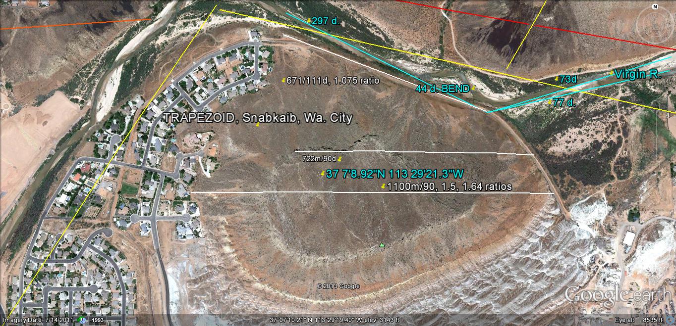
N x segment length/pi. According to the dominant DIRECTION, the AGE may be approximated by: DIAMETER/mm/year= YEARS (mm/yr= km/m.y.). Shnabkaib- which is a RISE adjacent to the WA million year FAULT, is an example, where the feature has EMERGED in relation to the 1 m.y. VIRGIN RIVER BEND (a 1-2 m.y. OCTAGON passing through the Santa Clara River Valley- creating REGULAR DESTRUCTION via the "BLUE CLAY" SLOUGHING, the RAMPAGE of the FLOODS in a 4 year CYCLE, and EXPANSION of Virgin River ARCS at the Washington City trail north of Snabkaib):


Farther away is the recent HIWAY BUCKLE on the Page Hiway 89:
The St. George, UT area is most sensitive to DESTRUCTION, because the St. George BASIN is at most 2 m.y. of AGE, and it is moving at rates of quarter inch to as much as 1 foot yearly (see the Santa Clara MUD FLOW from the "BLUE CLAY"):


The LINEAR DIVIDER for the area is REMARKABLY near a N-S VECTOR along Chapel Street (visit this street to see the MUD SLUMP, on the NW side of the street- the house is CONDEMNED):


A large view is shown above, and the FRACTURE PATTERN on the WAVE-DISPLAYED ROADWAY below:

The EQUATION (360-X)/X= INTEGER cannot
be solved for I= 0, and the solutions for commonly-encountered POLYGONS are as
follows:
I= 1, X= 180
degrees is a reference, since this relates to a REVERSAL;
I= 2, X= 120
degrees- portraying a 3-SIDED POLYGON (see Great Slave Lake below);

I= 3, X= 90
degrees, or the ORTHOGONAL FRACTURES perpendicular to bedding planes;
I= 4, X= 72
degrees- which is 10 times the 7.2 latitude TRANSFORM SPACING along the CA
coastline;
TRANSFORM SPACING along the CA Coast:
I= 5, X= 60
degrees- yielding a HEXAGON, such as exists on OUTCROP SLOPES;
I= 6 does NOT
YIELD even degrees of the COMPASS ROSE or of rotation;
I= 7, X= 45
degrees, yielding an OCTAGON. This should occur ATOP MESAS, see Checkerboard,
Zion NP:

EXPANDING the top view:

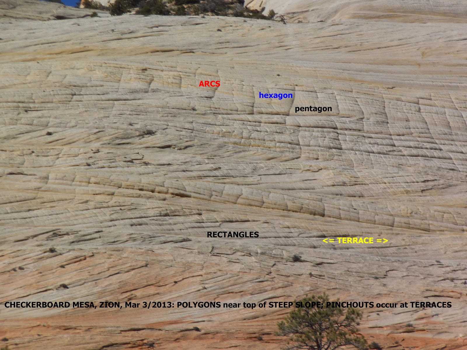

I= 8, X= 40
degrees, portrays a PENTAGON- which occurs on a slope ABOVE a 4-sided vertical
OUTCROP;

I= 9, X= 36
degrees- 1/10th of a circle; this is so close to 40 degrees, that it
may be difficult to ascertain;
I= 10 does
not yield an even number of degrees slant;
I= 11, X= 30
degrees, a 12-sided POLYGON- a DODECAGON (rare in usage, but common in CRATERS);
I= 12, 13
have NO SOUTIONS!
I= 14, X= 24
degrees CANNOT be distinguished from 25 degrees, unless I improve MEASURING
ABILITY.
I= 17, X= 20
degrees, and this 1/18th of a circle is NOT COMMON!
!= 19, X= 18
degrees- 1/20th of a circle, and difficult to distinguish from X=15
degrees, for I irregular;
I= 23, X= 15
degrees- 1/24th of a circle, and the MOST COMMON, to be used as the
MAIN REFERENCE, and, I= 35, X= 10 degrees is near the LIMIT of usage with
GOOGLE EARTH.

LIDAR (laser beam viewing at non-vertical, with software to remove vegetation):
NOTICE THAT 4 waves are shown, at approximately 15 degrees LATERAL SPACING!
Stay TUNED!
,