
750 meters to the EAST is found the ANOMALOUS LOCATION shown below:

Above photo shows faint discoloration in the Sea Floor, some with SILTATION in ARCUATE patterns, and those of greater interest- the iron colored LINEARS:

Below photo is blurry, but shows the beach to be hiked, along with the SILTED (Disturbed) area offshore:

(Yellow linears are faint, and you should bring these up on your computer to clarify)

Using an UNENCUMBERED Computer, the most obvious line is measured for length and angular change from E-W. NOTE that the Google Earth software shifts and rotates the linear. The measurements are TRUE, but the lines are off the TRACE, and indicate WRONG Angles:

The Compass ANGLE is 93.74 degrees (subtracting 90d, Venus has 3.4 degrees Inclination), and the LENGTH is 1548 meters, compared to 377.5 km, or 3.398 x 111.111= 1/244 ratio. Jupiter is closer, with 1.344 x 111.1111= 144.88 km yielding less than 100 ratio. This is a test, and we will use only the Venus Inclination!
Further east, the yellowish linear angles off twice, and these are shown in the below photo:

BOTH of these calculations together show a SHIFT between them (.76d), and indicate that Uranus, with its .77 degree Inclination above the Ecliptic Plane, has sheared this yellowish LINEAR! The only way we can check this further is to find whether CRABS like this location (with its organic stink and exotic chemicals). Crabbers, You can contribute your CATCH information, noting whether there is a better HARVEST along this line (which is OFFSHORE Silver Creek drainage)!

The Esperance sandstone is usually identified by this Iron COLOR, but now we have to contend with the iron deriving from SHEAR at the Sea BOTTOM, (which yields iron from up-welling, similar to the Iron SPRINGS on the south side of Penn Cove):

These COMPLEX THRUSTS will be reviewed:

Hike starts at the Beach, parking at the end of the South Mariners Beach Road:

We'll try to locate Indications of the ANALEMMA ANOMALY shown offshore, from the Beach clues:

ORTHOGONAL View of Beach:

DUE SOUTH of these Anomalies is Baby Island, which has Faulting at Saratoga Road cliff SPALLING:


LARGER VIEW:

Above N-S linear cuts the North shore MIDWAY between Baby Island FAULT and Fox SPIT; this is magnified below:

Above shows an INFLECTION and an ABRUPT Border of the siltation (indicating a boundary between North movement to the LEFT, and South to the right along a faint N-S division (Meridian).

ORTHOGONALLY, to show greater DISTANCE:

ORIENTATION from a Peat LOG:

Peat LOG orients N140E, near N-S, indicating the Movement or SHEAR Direction:

Photos above and below were made 31 Jul/2014:

SHEER Cliffs exhibit the THRUSTS created by the LATERAL MOVEMENT (notice the 90 degree turns- RECTAMGLES):

These will be re-Photoed:


Above ARC of a quarter CIRCLE, can be measured for the distance with the 90 degrees FRACTURE SEPARATION and DIAMETER to find the TIME INTERVAL for development. 10 meters yields 360/90= 40 meters, which is divided by Pi and then 16.24 mm/year= 784 years, approximately (ALL since the Last glaciation indicating that this had NOTHING to do with the ICE load). This is a HARMONIC (one thirty thousandth) of the 23,500 year PRECESSION of the Equinox, or Milankovitch's CYCLE!

TALUS Slope FAN LOCATES the VERTICAL SHEAR and the impetus for the More RAPID spalling:

VERTICAL FRACTURE Location:

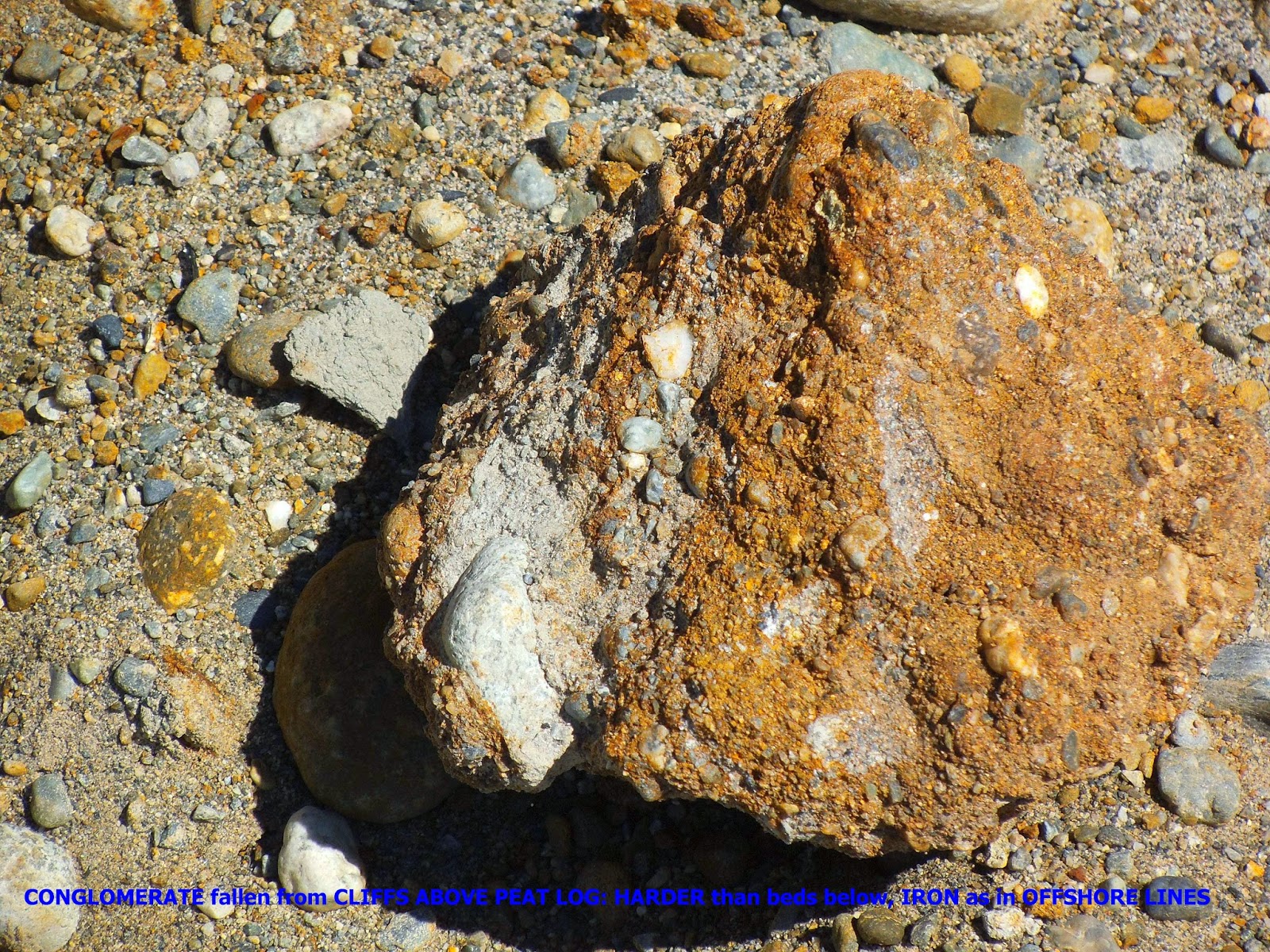
SAMPLE of Conglomerate ERODED, with iron cementation, Iron Carbonates?:
LINEAR spotted on Google Earth OFFSHORE:

ENLARGED, for view of SILTATION Ellipse:

Faint TRACES should be OLDER; calculations indicate less than 5000 years INTERVAL TIME (NOT necessarily the AGE). The strongest CONCLUSION is that the "yellowish Color" is due to IRON, which may rise along the shearing LINEARS. The location of an iron spring to the south at Penn Cove Parker Road is COMPARED to this color:

There is a hole ABOVE the springs, formed by the SLICE:

Sprimg is located at Penn Cove south coast:

Bay with E-W yellowish LINEAR:

I will hike this beach soon, and interested parties may contact me at:
overonharold@yahoo.com
The Olympic Peninsula, Mt. Olympus, and Juan de Fuca (JdF) have been shown to be IMPORTANT to the analysis of Whidbey Island. Below are Google Photos of the ACTIVE AREA near Crescent Lake, Sol Duc HOT SPRINGS, and the Olympic Geothermal emissions. Sol Duc is near the Calawah FAULT, and Olympic Hot Springs is on it! It is interesting that the HEAT occurs where the DRAINAGE changes to N-S (Elwha River) from mostly E-W for the peninsula:

Above caption of direction is INCORRECT; it should be oriented E-W, the same as for the south side of the lake! This analemma-shaped RISE has been laterally shaved, likely by ice movement.

CLOSEUP:

Above are the VERTICAL Beds, tracing E-W, and below is the View to the West:


Below is the VIEW to the South, at the 101 Hiway, showing the FRACTURES, on upright METASEDIMENTS:

GOOGLE EARTH VIEW:

Crescent Lake is at the left, above, and to the right, below:

Crescent Lake, east above, and the LODGE is shown below:

The USUAL Analemma has a DIVIDER indicating that the Equation for analysis is referenced to 72 or 60 degrees. I chose 72, since this has proven most ACCURATE for Whidbey Island. It yields a bit larger than 2.16 M/Sun ratio, indicating that the area is at the edge of the CRITICAL COORDINATES:

Analemma above is a RISE, between two SINKS, illustrated by CATTAILS, and represents an UPLIFT, which was shaved by the ICE during the Glaciation. The Vertical Strata orient E-W, unlike that on the erroneous caption. This is SIMILAR to that along the Crescent to Sutherland line of Lakes, and has been separated by a Landslide to the east. Below is the view UN-LINED:

Olympic Hot Springs emerge along the Calawah FAULT:

The Boulder Creek is the reference to find the Hot Springs. The composition is that of Meteoric water heated by the Hot Rock (assumed to be from Lateral FRICTION). NO Deep indications are noted for anything in the Olympic UPLIFT, except for the PREVIOUS CYCLE of under-lying basalt (which must derive from the Crust, Mantle contact by BOUYANCY):

DYNAMICS of the Northern part of the Olympic Peninsula are shown by:
1. Hot Springs, where Olympic Springs lie on the Calawah FAULT, near the INTERSECTION of Elwha and Sol Duc Rivers, and Sol Duc Springs are to the south of this Latitude;
2. The CALAWAH FAULT follows the Sol Duc River until Sappho Town;
3. River ORIENTATION is E-W along Sol Duc, and S-N along the Elwha, indicating a MAJOR ANOMALY; and,
4. Seastacks are HARDENED North of the Mt. Olympus Latitude, yielding RESISTANT Metasediments and RAISED BEACH REMNANTS!

ELWHA River, above, intersects the Boulder Creek, along which occurs the Olympic HOT SPRINGS:

Following the ARCUATE TRACE from Oylmpic Hot SPRINGS to the Sol Duc River, first departure from the ARC:

Measuring the Calawah FAULT on an un-encumbered computer, I trace 20 km to an ARCUATE intersection with another ARC of radically-DIFFERENT Orientation:
Altair Campground COORDINATES: 48.012222N 123.591444W yields {(72- 49+)/49+}= 2.132; {(180- 124+)/124+}=2.249, which is N/U at 2.29 ratio.

Calawah Fault AGE IS 5 m.y., much YOUNGER than the 32 m.y. Oligocene start of the SUBDUCTION! This I interpret to be the TIME INTERVAL for creating the Crescent Lake and nearby Lateral SHEARING Fault. Why do I use 32 m.y. when the oldest rocks are POST-Eocene? The Binary THEOREM has Destructive EVENTS at multiples of 4: 1, 4 (NW Territory Fragmentation around Byam Martin Island), 16 (Columbia Flood basalts), 64 (KT Chixculub event), 256 (PTr, or the Appalachian OROGENY), etc. Benign events, such as Burgess Shale Cambrian 512 m.y.; 96 m.y. Cretaceous uplift, occur at 2, 8, 32, and 96 to 128 m.y. AGE.

A MAJOR Anomaly is found at Ruby Beach, in the form of HARDENING of the Haystacks, RISE (uplift) of the beach gravels, and ARCUATE scribing in the metasediments:

The Beach GRAVELS are uplifted to a higher ELEVATION above the Seastack or HAYSTACK, and this indicates that this portion of the Olympic Peninsula is still RISING (along with Hot Springs and Calawah FAULT INDICATIONS):

Notice the Vertical SHEARING ARCS, illustrating that Gravitation creates SHALLOW ROTATIONS.
Latitude of Ruby Beach HAYSTACK: 47.69N Latitude, or 7.25N of Mendocino (same as published Sun TILT):

ACTIVE UPLIFT of Northern part of the Olympic Peninsula is shown below:

The ARC, which forms the Maylor (Oak Harbor) Point to Holmes Harbor, Freeland will be SCRIBED from the two terminuses of the Waterways, to determine the INTERVAL TIME required:

The Pink LINE shows the Radius of ROTATION of Whidbey Island's Oak Harbor to Holmes Harboro, Freeland WATERWAYS, for calculation of the TIME INTERVAL required to form the ARC:

Measured from Offshore, the TIME INTERVAL is 32 m.y.; from Mt. Olympus, it is near 10 m.y.:

Re-CALCULATING, using the Oak Harbor to Holmes terminuses, the TIME is 3.4 m.y. for the Formation of the ARCUATE Waterway; considering the errors of this calculation, I will use 3.2 m.y.- which is a tenth of the 32 m.y. incipience. This analysis is similar to "ripples in the POND" where the Gravitational Waves travel outwardly, to form the present ARCUATE Waterway. The DISTANCE travelled is shown in a previous MEASUREMENT:

DISTANCE is 90.8 km, and this yields 90.8/32= 2.8375 mm/year lateral movement:

Above measurement requires checking, shown below:

Measurement and CALCULATION for the Hood Canal yields 9.79 m.y., showing the ERROR of using distorted ARCS (Hood Canal). I will measure and CALCULATE more closely:

RE-CALCULATION and Measurement of the Holmes to Oak Harbor ARC to its Radius of CURVATURE, yields a TIME INTERVAL of 7.35 m.y. This is 32/7.35= 4.354 RATIO of Olympus RISE to Initiation of the W.I. waterways ARC! There are 4 major troughs (SINKS) along the path, yielding approximately 2 m.y. each. This sugggests that a WAVE CYCLE is near 2 m.y. for a TOTAL of 16 waves from the 32 m.y. INITIATION of the Olympic UPLIFT! This analysis has large errors, but will be kept for COMPARISON with other similar WAVE MOVEMENTS.
RECAPITULATING, the BENIGN movement of the Olympic Peninsula, at 32 m.y. expands toward Whidbey Island with 2 m.y. CYCLES (waves), creating Bays and CRESTS along the path. Discovery Bay is one of these, and has the FORWARD "S" configuration, ignoring the nearby Island. Protection island, if included, makes a REVERSE "S"- which normally is a SINK. This is presented below;

Since Protection Island is ANOMALOUS, it is ENLARGED below:

"JERKS" show that there is a WAVE at Protection Island, but it is an UPLIFT (RISE) and NOT part of the forward "S"! There is a N-S divider also, yielding a BIFURCATION at the Island.
Viewing the JdF "big picture":

Above JdF channel is 45 degrees East of the Diomedes Natural Prime, but the 48.56N Latitude does NOT FIT the Mendocino REFERENCE; it is 8.12 degrees north, and we have already found that there is a change at the "right turn" entering the JdF channel:

This emphasizes that the new REFERENCE nust be used; from previous analyses, it is 48.56N Latitude!
REFERRING to the JdF change of Qsna at the movement to the NW, as compared to north for the Olympic Peninsula:

Above RED trace refers to the SHIFT of the tidal influence (north is to the left), for the TRANSITION from the Qsna lesser ORB to the Major portion of the North American ANALEMMA, towards Alaska:

ENLARGING:

Finally, the LOCATION of the NEW REFERENCE can be estimated:

Whit-Be-allovous
(to the cadence of Sullivan’s “A Modern Major General”)
A Fight Song
We trod the beaches of the land, with footprints so magnificent,
We take good care and prudence, since we’re seemingly significant;
We are geological, with thoughts so ecological-
We solve the island’s many myths, with motives almost nearly always logical.
We step o’er rock and fragile stone, with boundless love resilient,
Our thoughts, forever prime, are always bordering on the brilliant-
We zig and zag, it’s in the bag, the secrets of a stratigraphic crag,
Our yards are always full of Nature’s bounteous anticlinal swag.
Whew!
We look at cave and cliff, for clues that often are mysterious,
We form our explanations, which then sometimes are delirious;
We’re ever right, with thoughts so bright, the clays we test with subtle bite,
The Mastodons we lately seek, are almost always out of sight.
We sniff the waters of the seeps, which are mostly full of Carbonate,
We draw straight lines on maps, over which we then can fulminate-
We look not for the animal, not vegetable, but mineral,
We seek to find the local sense of Earthy Science-in-General.
We find the island’s many faults are certainly near left-lateral
The moraines make Points, but Heads (Tombolos) are quaintly mostly platter-al,
We are Geological, with thoughts so ecological-
We solve the islands many myths, with motives almost nearly always logical.
Our rare scientific group is most certainly gregarious;
With the exception of a stately few, they are hardly e’er nefarious-
They most certainly show attentiveness, to the total group’s inventiveness
They never forget a single clue, keeping constant retentiveness.
We’re constantly amused almost, by the manly interaction,
Of the way they stand their solid ground, while their stomachs are in traction-
While some will look at cuttle fish, rarely they’re rebuttal-ish,
They follow simply to a man, the leader’s every whim and wish.
They never waste a word or deed, showing ultimate economy;
They incorporate all useful fields, even invertebrate Taxonomy-
They map all Points, align all Joints,
Whenever it is possible, they listen to whomever USGS anoints.
We march out in the sand-filled fields, with ultimate sobriety;
Then we announce our final facts, with tremendous notoriety;
We use all of our abilities, with promising agilities
Before there is a final loss of all of our facilities.
We incorporate every certain fact, remaining ever all aghast;
With completely serious rectitude, we follow an iconoclast!
We are Geological, with thoughts so ecological-
We solve the islands many myths, with motives nearly always almost logical.
Harold L. Overton
To be CONTINUED.