BELOW is an example of part of a FIGURE 8, formed with the Hurricane, UT golf MEANDER. It lies across the Virgin River from the LEEDS Crater- the start of a 2 eruption sequence, which will erupt again within the next 30,000 years (100k.y. less that time of last eruption- 70 kiloyears):

Above is a DIGITAL PHOTO of the SHEAR LINE sets (2 or more) viewed north of the Virgin Meander, below the Hurricane Golf course. These tell a TALE of DESTRUCTION!

Above is a SPIRAL or ANALEMMA, with one portion missing-in the ALEUTIAN CHAIN (where some of the MOST rapidly-changing VIOLENT WEATHER in the world occurs); BELOW is an ANALEMMA FORMED BY THE ANNUAL PATH OF THE SUN, REFERENCED TO EARTH:

.jpg)
The middle of the following photo shows an atmospheric tides' WEATHER ANALEMMA- which is FORMED by RISING LOW PRESSURE AIR. This is in the shape of a FIGURE 8 (with the usual SUSPECTS- the portions missing due to inability of spirals to reconnect with OLDER LARGER ROTATIONS):

EXPANDED:

ANALEMMAS or Figure 8s (with portions missing) are HARBINGERS of VIOLENT OCCURRENCES- in this case, for a SERIOUS STORM over ZION National Park. The Santa Clara River FLOODED near the town of SANTA CLARA (50 km from Zion NP), which has a tributary draining into the Virgin River. This is for the August 14/2012 date,and the flooding occurred on September 11 (both NEW MOONS- one month NOTICE). The ANALEMMA may be in the shape of "S" arrangement, similar to a SWASTIKA, or it may be a bacwards S. The shape is determined by the relation to LATITUDE, where those inside the EQUATORIAL BULGE 40N are VERTICAL (above case), or outside HORIZONTAL. This arrangement SHOWN is NOT different at the POLES:


The SANDY HURRICANE is illuminating, since it shows how a HURRICANE is related to the LARGER PICTURE of ATMOSPHERIC and EARTH TIDES:

Associated with the SANDY HURRICANE is an EARTH VIEW- over the Pacific Ocean, WESTERN HEMISPHERE. This photo was taken at NOON, Oct 25/2012, and shows the MASSIVE STORM asociated with Sandy- where the ANALEMMA OCCURS from the Bahamas to Mexico. This shows that the storms are connected over almost the entire QUADRANSPHERE- the part exhibiting a HIGH PRESSURE over the SW USA and LOW over the Caribbean (a clear sky high CW and a low CLOUDY CCW form the 2 parts of the Figure 8 analemma):

A NOTE ABOUT ATMOSPHERIC GRAVITATIONAL TIDES:
The lower atmosphere, below 10.000 meters effects almost all of the changing weather- such as storms, heat and moisture. This portion is readily viewed in EARTH SATELLITE PHOTOS. These are available from NASA, as hemisphere photos each 3 hours during sunlight. Below is one which allows predictions to be made:

It is difficult to see the "BIG PICTURE" from the ground surface, but occcasionaly I am lucky:

PVM (Pine Valley Mtn,) can be viewed from the volcano behind my house; this relates that there will be another destructive storm before the next NEW MOON- Jan 2013:

Looking at a MINOR JUNCTION at the confluence of Kanab Creek and Pipe Springs wash, the MILANKOVITCH CYCLES can be seen and measured. There, the AXIAL (41 m.y.), PRECESSIONAL (25 apprx.), and the ELLIPTICAL (100) CAN BE VIEWED CLOSEUP- hikeable, in flat and level country:

This DEVELOPMENT is continuing, and the AGE is equal to the TIME INTERVAL; notice that the intervals are greater than MILANKOVITCH'S, and a SCALING FACTOR may be calculated for comparison. It is 1.196, and shows that the precessional (variable, from 23 to 25 k.y.) is reasonable at 24.3 k.y. The TRAPEZOIDAL FORMATION (tit) arises to the north, and has formed within one cycle.
This may be explored at the NEARBY KANAB-JOHNSON WASH, where the age is barely sufficient to develop an ANALEMMA or trapezoid:

This will be MAGNIFIED after hiking to the confluence feature:

Attempting to CALCULATE AGE from ARCS adjacent to the TRAPEZOID or TRANSITION ZONE proved futile; the CURVILINEARS are so close, that ERRORS are LARGE. THE ADMONITION IS: DO NOT USE TRAPEZOIDAL SPACE for CALCULATION!

VOLCANIC SITES, as with the ALEUTIAN SPIRAL, are often identified by ADJACENT ANALEMMAS- PARTICULARY with intersecting RIVER VALLEYS or SCARPS:
 Above region demarked by the Hf DIVIDER (Wasatch line, from Salt Lake City, UT) exhibits several ANALEMMAS- the oldest being 2.07 m.y.- the date of ELTANIN, or the initiation of the ICE AGE! YOUNGER are smaller in diameter, and SUBDIVIDE OLDER, LARGER ONES (Sand Mountain has an associated Sand Valley, and Little Creek Mountain has Little Creek.
The HURRICANE FAULT has some REPEATING FEATURES, which bear further investigation. These occur similarly for the QUAIL-VIRGIN ANTICLINE, where there is a REGULARITY of AXIAL-PRECESSIONAL CYCLES occuring with an obvious uplift: MT. TRUMBULL VUCANISM, in the above case.
ANALEMMAS may occur in SINKS, for Basin and Range FEATURES (such as east Oregon and Nevada). This one is north of 40N latitide, so is oriented almost E-W; those within the EQUATORIAL BULGE ORIENT N-S:

Above is the FEATURE MAP, and below is the Google Earth view:

A SMALLER analemma is shown for the PORTION of the Virgin River, where the river makes an abrupt RIGHT TURN:

CLOSEUP:

The ABOVE FAN is enlarged to show that it was not in contact with the air, at the time of its arrangement. USUALLY, GEOLOGISTS suggest that AIR COOLING forms the perpendicular-to-the-outside-air COOLING CRACKS:


The Virgin River banks collapsed during 2011, and have been repaired; the damage is shown below:

FOLLOWING YEAR:
The City of Washington, UT maintains this trail, and it is easily accessed for a 2-4 mile HIKE; there are many springs- due to the active rotational shear, and the trail is black-topped (accessed across the Coral Canyon road from the new I-15 parkway- notice the VEGETATED "S" moisture-contained valleys):


ACTUAL TURN of the river occurs 1 km to the SW; it illustrates the ANALEMMA better, since the right turn DEVELOPS the Figure 8 on the right side. Formation of RISES, SINKS, and ROTATIONS is shown in the following photo (this is skewed, and the ORIENTATION is nearly N-S):

Virgin River bend to Schnabkaib, showing DEVELOPING ANALEMMA, in connection with the Washington city 1 m.y. fault crossing I-15 at the "boiler" warm springs:


Now for the 1 m.y. "BIG PICTURE":

BELOW ia another "S" shaped ARROYO. It has no springs, and is the LEADING EDGE of the ENCROACHMENT of shear arcs into the otherwise rolling GREEN SPRINGS AREA Jn SAND DUNES. The FRACTURES in the creek bed align with the CREEK TREND:


The MOUNDS would not be noticed, except for the GOLF LANDSCAPERS:


This is being investigated by foot, since it pertains to the 2 m.y. RE-ORIENTATION of the Virgin anticline- creating a right turn- above- and a left turn at the PURGATORY SILVER DISTRICT-LEEDS VOLCANO (across the Virgin River from my dwelling, where I can scan it daily). I expect that the VULCANISM there is ON-GOING, since there is only a single crater, where 2 almost always erupt (e,g, at 1 m.y. ago, and at 1/4 m.years, for Ivin-Sullivan Knolls). Below is the MEANDER associated with the Leeds volcano- which lies just to the NE of the well-developed feature. NOTICE that the Virgin River erodes the NE banks and creates larger diameter (increasing TIME of development) loops- indicating passage of time- which is proportional to DIAMETER:

Leeds Volcano is located across the Virgin River from the Figure 8 Meander above, and the two entities are related in TIME- the meander developing NOW and simultaneous with the 70 k.y EXTRUSION. The continuation of the SOUTHERN uplift is smaller than the EMISSION SITE to the north, and is RISING NOW. There is stink and chemical change on-going, but I have found NO THERMAL INDICATIONS (there should be some warm seep, which I will eventually find).

EVERYTHING on Earth is connected! Below is shown how the movement of the 2 m.y. ANTICLINE to the east has created enough heat in SLIDING of the REDBEDS to create "TIRE SKID MARKS" (as of your tires in gravel, whenever you make a sharp LEFT TURN) and the LEEDS VOLCANO- just behind the Virgin Meander:
LEEDS CRATER lies to the NE of the SHEARED and ROTATED (notice the arcuate fracture lines) Virgin ANTICLINE. Now you can understand the JAGGED PORTIONS:

The ROTATION procuces noticeable vertical faults with accompanying ELLIPSES, LIGHT-COLORED ARCS, and SHEARING ZONES:


FEATURES BETWEEN ABOVE MEANDER and the LEEDS CRATER are very revealing, and can be viewed at the NEW CANYON GRAND TRAIL- a 1 mile hike each way, to the shear cliffs above the VIRGIN RIVER:

The REVERSE "S" indicates a CW ROTATION- which is correct for the CW trace along the Virgin, encircling SAND HOLLOW SINK and Sand Mountain RISE:

Analemmas occur at MAJOR EVENTS- such as the Hf volcanic fields, and at the known intersection of the Virgin Gorge LATERAL FAULT and the PARASHAUNT N-S FAULT!

Cedar Pocket is an excellent camping site, and has its own EXIT on I-15 freeway:

PARASHAUNT FAULT may be seen on the right side (north) of I-15 Freeway feeder, 100 meters north of the overpass to the Cedar Park entrance:

Since this is SUPERIOR to geological CLASSIFICATION, below is shown the INCIPIENT ANALEMMA, WARM SPRING, and WA City FAULT TRACE, where the next VOLCANO WILL ERUPT. I have the location, but not the time- and it could be anytime in the next 40,000 year MILANKOVITCH cycle. The CITY should monitor the temperature, to find the rate of the spring's change:
ANOTHER "GIVE-AWAY" is the occurrence of MIMA MOUNDS- which occur whenever there is COMPRESSION and "CHATTER":

The MOUNDS would not be noticed, except for the GOLF LANDSCAPERS:
It will be INSTRUCTIVE to hike the site marked 872m arc, since this is the PRESENTLY-DEVELOPING PORTION of the ANALEMMA. SPRINGS occur in the actively-shearing zone, and Green Springs should reveal added information.
Google Earth view of the WA City fault crossing of I-15, where the "Boiler" warm spring PRESAGES the next VULCANISM- 20 km (a million years' separation) from Hf and 40 km from Crater Hill:
+springs,+Wa.+City,+UT,+I-15.jpg)
CRATER HILL, at the edge of Zion NP:

Crater Hill from across the Virgin River at the Horse Canyon road:

NOTICE! ABOVE are the NECESSARY FACTORS to MONITOR VIOLENT EARTH EVENTS in ADVANCE! You can easily WATCH FOR ANALEMMAS- EITHER in the ATMOSPHERE, THE ARCUATE ROAD BREAKAGE or in the EARTH CRUST (MUCH MORE SUBTLE)!

Google Earth shows last year's view, before road repair:

Taking a LARGER VIEW:

ANALYZING WITH EARTH TIDAL RATES, according to the appropriate QUADRANT:

GOOGLE PHOTO ABOVE shows how the ANOMALOUS SNABKAIB UPLIFT is part of the Figure 8 ANALEMMA; for every RISE, there is a SINK, with an INTERVENING TRANSITION ZONE (think TZ between the RISING CP and SINKING Basin and Range- which is where the VIRGIN River - Hurricane fault to the Beaver Dam Mountains exists, on a larger scale).
We now have 6 separate ACTIVE ANALEMMAS. which we can monitor in our LIFETIME:
1. The small canyon at the AZ border- Honeymoon trail and adjoining BOX CANYON;

2. The COMPLETED VIRGIN RIVER ANALEMMA, at the junction of Laverkin and Hurricane;

Down stream 1 km is the VIRGIN, ASH, LAVERKIN CONFLUENCE, where there is ACTIVE SHEARING of BLUFFS, causing a house to be condemned. The PRELUDE to this is shown on the map below, where the advance of the meander is to the NE, where the shearing is taking place. This FIGURE 8 is presently being formed, and the movement is near 10.24 mm/year to the NE (about 3/8th of an inch):

3. Ongoing Meander at the Hurricane Golf overlook;
4. Cedar Pocket park and campgrounds, which is related to the Parashaunt active 1 m.y. FAULT;
5. The Snabkaib-Virgin Dam Figure 8, which has had a CIRCULAR ROAD-TRAIL COLLAPSE a year ago; and,
6. The VEYO Volcano and Hot Spring.

WA STATE is NOT IMMUNE- this is in the town of OAK HARBOR- next to the OAK-CRESCENT HARBORS ANALEMMA (tracing E-W)!

Oak, Crescent Harbors ANALEMMA:

This FEATURE is north of 40N Mendocino, CA, where the analemmas reverse their orientation from N-S to E-W (outside of the EQUATORIAL BULGE).
The main CONCLUSION which should be APPARENT:
ANALEMMAS DEVELOP RAPIDLY at sites of IMMINENT DESTRUCTION. They can be easily monitored AFTER FINDING the FIGURE 8, and noting the RESULTING DAMAGE, as for the one at SANTA CLARA, UT- where the river destroyed houses near the banks on Sept 11/2012, at the LINEAR SEPARATING the BLUE CLAY SHEAR-ROTATION ARC (center of town, near the Hamblin Museum) from the BROWN HILLS RISE on the south side of the river:

Santa Clara "BLUE CLAY" MOVEMENT can be slowed, but not stopped! It results from a CW rotation at the EXHIBITED ARC, where concrete piling continue to slump toward the CENTER of ROTATION!

CW-MOVING arc is shown below- centered appropriately at Chapel Street, where the road is the centerline- separating 20.48mm/yr movement on the left and 10.24mm/yr on the right! Notice the CHIP-FILLED LINEAR- which is NOT ALONG THE EXACT CENTER, and can be measured by compass to yield the separation of MOVEMENT RATES.

BELOW IS THE RECENT WARNING: FLOOD OCCURRED Sept 11/2012:

REPAIR is being done on the Sept 11 FLOOD WASHOUT:


TIDAL RATES in the EASTERN HALF of any circular development are being made more ACCURATE, and they are between 10.24 (SOLAR) and 17.48mm/yr. I will develop this from other than the GULF OF MEXICO, BELOW, since the 41m.y. SHIFT has created DESOTO CANYON, and disrupted the REGULAR PROGRESSION of the CONSTANT RADIUS in the 2 quadrants:

DIVERGENCE of TIDAL EAST RATES is shown along the WHITE LINEAR. We will have to live with this ERROR until I find a better model:

Hurricane SANDY forms an ANALEMMA:

 PROGRESSION of Sandy is shown by DATES:

Discovering ATMOSPHERIC TIDES- as shown by LOW-LEVEL CLOUDS (RISING CCW moisture-bearing circular features)- yields information about EARTH TIDES on a scale useful for daily use. Since the viscosity ratio is large for rock, as contrasted to air, the time scale is also contrasted: at least 1 million to one. This allows EVENTS OCCURING 1 m.y. to be observed (and predicted) in a day's TV viewing:

Considering that you missed it, below is the ANALYSIS:

These NASA PHOTOS from space will be followed to determine the VALIDITY of the ANALYSIS:

I will follow this daily, until the NEW MOON of 14 Dec/2012:
3 hours LATER:

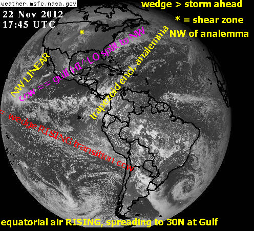
Above photo predicts that an EVENT WILL OCCUR by the next NEW MOON, which will be NOTICEABLY DESTRUCTIVE. The weather is already destructive enough in the NE, and the path through the Gulf of Mexico portends that an event will occur along the N-S PATH TOWARDS the New Madrid-Mississippi River bend in the river. This is a repetition of the INFAMOUS 1812 QUAKE which created SUNKEN LANDS in Northern Arkansas.This was 200 years ago Dec 2012, and 100+ years since the TUNGUSKA, Siberia VIOLENT BLOW-DOWN of a large section of steppe trees! The first WARNING OCCURRED a year ago at Clintonville, WI, with the infamous BANGS! (ALONG the same N-S meridian as New Madrid, Chicxulub, and the center of Hudson Bay). Incidently, the MAYANS somehow discovered this meridian, and proceeded to build their principal shrine- TIKAL- along it! This meridian is treated mathematically as a LOXODROME, and it proceeds as a LINEAR, until reaching its TERMINUS- where it becomes unstable and creates a MUSHROOMING-SPIRALING HEAD- similar to the development of SANDY HURRICANE (upon reaching the Jersey shores).
Below is the digital photos of the SHEARING-ROTATING Pine Valley DUO, as of 13 December/2012. It indicates more DESTRUCTION near the SANTA CLARA RIVER, within the 4 weeks prior to the next NEW MOON:

ANALYZED:

Save this PREDICTTION! IF CORRECT, this is valuable for VIOLENCE ADVANCE NOTICE! If not, you can have a GOOD LAUGH.

STAY TUNED!