SULLIVAN KNOLL IS THE MOST CONVENIENT CRATER OR CONE TO DATE. IT EXHIBITS 3 PHASES:
1. IVAN KNOLL PRECEDED IT AT ABOUT 1 M.Y.;
2. AFTER A PERIOD OF COOLING, WHERE THE BRITTLE FRICTION WITH WALL ROCKS CREATED POCKETS OF MAGMA BY ROTATION CW, A REJUENATION CONE RESULTED:
3. FINALLY, A LATE STAGE OF REJUVENATION CREATED MORE VIOLENT SILICEOUS EXTRUSIONS, WITH LAPILLI AND CLINKER.
 WE WILL LOOK TO THE PACIFIC BASIN FOR LONG TERM DATES AND SHEARING ROTATIONS, WHERE SEAMOUNTS AND ISLANDS HAVE BEEN MEASURED FOR GEOLOGIC AGE. THIS WAY, WE CAN MEASURE BOTH DISTANCE AND RATES OF MOVEMENT (FROM THE INDEPENDANTLY-MEASURED AGES):
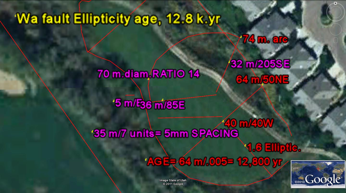
Intermediate Latitudes have westward CRUSTAL MOVEMENTS, due to tidal shove along Latitude lines, of 2 cm/year. These present shear “tic marks” on Google Earth photos separated by 20 km each million years (20 mm/yr).They are readily viewed in ocean basins, since there is little erosion to erase the traces. Onshore, they are present, but require significant magnification for measurement, The following photo of the Washington City fault, UT and associated GRIDS, Milankovitch SHEAR CIRCLES, and arrangement of drainage along fractures produced by the shear shows the portrait. NOTICE THAT THE GOLF "GREEN" HAS WHAT LOOKS LIKE IRRIGATION LINES BURIED- 2 SETS RUNNING AT 45 DEGREES TO EACH OTHER; THESE ARE GRIDS PRODUCED BY "DUFFER" REQUIREMENTS (SOME CAN BE SEEN TO EXTEND INTO THE BORDERING ROCKS):
I have not indicated how I got the time element in the above photo, and it was found in reference to the age-dating noticed and measured along the Mendocino Transform in the North Pacific basin. The following photo shows an anomaly along this transform, and it presents two features: THE "RIP" FROM CA COAST TO THE START OF THE OPENING IN THE CRUST MEASURES 82 KM. THIS DIVIDED BY THE MEASURED (RADIO-DATING, 40 TO 41 M.Y.) AGE OF KIMMEI SEAMOUNT YIELDS 2 MM./YEAR:
1. The normal EARTH-MOON TIDES produce a spacing of 2 cm/year. This was previously found by using the published age of the Eltanin ICE AGE strike of 2.15 m.y. solving the time necessary to produce 2 such 20 km tics related to the movement to the west (each small tic represents 1 m.y.- 20 km/m.y. FOR EARTH-MOON, AND 10 FOR EARTH-SUN TIDES). There is a small error in all this, due to the difference in Milankovitch 41 k.years AXIAL cycles and 40 km separations of GRID SPACINGS found along the Hurricane fault. The start for involving TIME relates to the Mendocino, CA 40N Latitude Cape, which juts out to sea (relative to the subduction to the north).

I DON'T KNOW HOW THEY PHOTOGRAPHED THE CIRCULAR VIEW OF THE OCEAN SURFACE, SEPARATELY FROM ALL OTHERS, BUT IT IS INSTRUCTIVE TO MEASURE THE CONFLICTING WAVE PATTERNS AT THE WATER SURFACE. THERE ARE TWO, SHOWING SIMILARITY TO THE CONTINENTAL SHELF VECTORS HEADING TOWARD THE COASTLINE:


2. The above analysis depended upon previous findings, that regularly-spaced parallel GRIDLINES occur both in the ocean basin and on the uplifted Colorado plateau, CP. These have no connection with time yet, and the age of the features must be determined from measurements made elsewhere. Ones I have used are the Kimmei seamount of 40-41 m.y., the Eltanin asteroid strike of 2.15 m.y. and the 1 m.y. Divide crater adjacent to Hf. Below is the Divide flow and crater, used because it is not encumbered by artificial features and by immediately adjacent rejuvenation cones (such as occur with Ivins Knoll and its satellites of Sullivan Knoll, Red Ash crater, and Radio Tower hill).


Inspection of the Milankovitch rotations near the Hurricane fault at the Divide basalt extrusions near the AZ border with UT yields small cycles- axial and precessional, as shown below:

I have scanned progressively westward, along a latitude line (E-W), so that I could find an arcuate feature which was orthogonal at the AZ border and which formed an arc encircling the Divide extrusion. The only one which “fits” the requirements is the one passing through Gunlock, UT. This feature has 40 km radius and 80 km diameter, which divided by 32 km/million years yields an age of 2.5 m.y. EARTH TIDES MOVE THE CRUST WESTWARD, SO THAT AGE DETERMINATIONS MUST BE MEASURED ALONG AN E-W LINE. The Mendocino transform starts from CA along this orientation, and gradually orients to the south, so that the continent has been oriented with its present movement since the Kimmei seamount of 40-41 m.y. EXPANDING THE MENDOCINO SUN TIDES ENVELOPE, DO YOUR OWN COUNT, TRYING TO DETERMINE WHETHER MY APPRAISAL OF THE KT STRIKE MAJOR N-S RIFT IS CORRECT:
Note the regularity of spacing for the “tic marks” shown along the Mendocino transform towards Kimmei:
Compare the extrusion above Hf at the FROG HOLLOW location, using the closest E-W latitude line for a reference, and the calculated age is 2.47 m.y.- similar to that at the Divide extrusion. These are larger than the expected Eltanin asteroid strike time of 2.15 m.y, hence give an estimation of the error created using this process. RECALL that all entities within the GRASS VALLEY rotation should be newly fractured and faulted for times less than 2 m.y. Older episodes of strikes, shear, thrusting, and rotation should be more faintly presented or eliminated by subsequent events. I WILL CROSS-CHECK THIS METHOD WITH FINDINGS FROM OTHER AREAS (INCLUDING OTHER QUADRANSPHERES).
THE ABOVE DILEMMA IS RESOLVED BY USING THE LARGEST MAGNIFICATION OF GOOGLE EARTH, SO THAT ALL SPACINGS AND CYCLES MAY BE VIEWED. THE ONE PERTINENT TO THE DIVIDE VULCANISM AND ROTATION OF THE 80 KM SHEAR CIRCLE AT LITTLEFIELD CREEK AND ROTATION IS 64 M (64 KM for 1000:1 RATIO OF diameter/spacing- compared to the 50:1 ratio found for AXIAL CYCLES, for Moon+Sun tides/yr), AND THIS IS SHOWN FOR THE LARGEST SPACING AT Hf (80 KM/64 KM/M.YR= 1.25 M.Y.- THE AGE OF DIVIDE EXTRUSION):

EARTH TIDE GRIDS at Laverkin GRABEN, HOGBACK and SINK
The town of Laverkin has numerous problems of sinking and slumping lots near the Laverkin Creek. Additionally, there is a rising and tilting block of CRUST to the west of the Ash Creek- called a HOGBACK. Other oddities include two creeks- Ash and Laverkin- which run side-by-side to confluence with the Virgin River. These are near each other, but never breach the intervening 600 meters; they present a pattern similar to the Arkansas River in Colorado state, where the river cuts through the Rockies, to flow in a circular arrangement to the east (along a sinking Great Plains- rotating CW). The Ash creek cuts north of Tocqueville after emerging as large springs NE of the town, and the Laverkin River cuts through the Hurricane fault and bluffs to cut canyons to the east- part of which is the Zion NP Spiral. These form a pattern shown in the following Google and digital photos:
Grids, Laverkin hogback


The hogback creates a line of fissures as it rises, making abrupt right angle turns to the west and north. These are in soft sedimentary sandstones, but are not filled by erosion as swiftly as they open (erosion rate < opening rate).


The GRIDS and their spacing, elongation, and orientation are shown in the first photo, and have some valuable information:
1. The orientation is 205 degrees, with ORTHOGONALS at 115 degrees, with indications of AXIAL circles (41,000 year Milankovitch rotations) and an elliptical cycle between the Hurricane fault and the river (100 k.years ellipse oriented along the 205 degree trace- centered appropriately near Central Street);
2. Hf is anomalously oriented similarly to the 205 degree features, with a circular arrangement evidently resulting from the elliptical shearing and rotation;
3. The HOGBACK spacing is larger than those to the east- 815 vs. 620 meters- and this shows the change of extension or E-W stretching. While the hogback “lays down” to the east, its angle with the horizontal (40 degrees, yielding cosine=.76) increases the spacing;
4. Hf orients normally N-S, due to the much larger feature of the rotation of the Colorado Plateau, CP. Nevertheless, the Milankovitch cycles of shear take precedence- proving their faster movement and younger age. Since I feel fairly confident that the 100k cycle is accurate, one can now measure the extension at its edges to obtain a tidal spacing- 60, elliptically, and 41 m. axially.
this results in 20 and 30 mm/yr dating rates(MOON: 20, + 10, SUN= TOTAL of 30 MM/YR). The ELLIPSE indicates an age of 43,300 years (60 m spacing, 1.0-1.3 km radius, 2 km/20 mm= 100 k cycle), while the AXIAL cycle (41 m. spacing at the edge of the circle) has an age of 12,730 years- the age of the “lustily searched” LARGE MAMMAL EXTINCTION ASTEROID, with a formation time of 26 k.years (at 20 mm/year). You can see that there is difficulty in interpreting the allocation of results with 3 separate cycles, which have not yet been distinguished as to whether they interfere with each other. My “GUT” feeling Is that they do not; otherwise there would be SPRINGS, VULCANISM,, or increased QUAKES near the town. The Pah Tempe hot springs are on the east side of Hf, and occur with BRITTLE FRICTION at intersection of Hf and Grass Valley rotation. Nearby vulcanism occurs at locations across the Virgin River, and neither of these (BEST GUESS) contribute to the cycles noticed in the Laverkin photo, but result from “horses of a different color”- rotations of the much larger CP and ZION NP.

TIME MEASUREMENT WITH HURRICANE CLIFFS “TIC MARKS”
A PROBLEM with using the Mendocino transform for measurement of time is due to the progressive slowing of the EARTH DUE TO FRICTION of TIDAL INFLUENCE of the MOON. Long term measurements find that the Moon slows the earth in its orbit by 20 seconds of time each million years. This is equivalent to an E-W shift as the orbit slows. Not only does the earth spin less rapidly, but the distance from the sun increases (EB decreases, and the earth becomes less elliptical). The following data shows the almost precise relationship:
1. 360 degree daily rotation of the earth is equivalent to 15 degrees per hour, or 15 minutes arc/minute of time;
2. A minute of arc at the Equator is defined as 1 nautical mile, where 1 nm= 1.85 kilometers, km;
3. Distance along a Latitude line varies with arc, along a Longitude line. At the Equator, it is defined as 1 nm, but this becomes smaller as latitude increases (at the poles, one minute change of arc has zero distance incurred). Hence, at mid-latitudes (45 degrees, N or S) the distance is .707x that at the Equator. This factor makes any E-W measurement suspect, when considering time: increasing latitude makes the relation of distance/unit of time decrease;
4. The calculated change due to this LINEAR CHANGE OF EARTH’S SPIN is predictable: 20 seconds of time, or one third minute= 5 minutes of arc. For a change each million years, the 20 seconds translates to 5 nm (9.25 km) at the Equator and 6.5 km at 45N;
4. This change with latitude may be offset, by calibrating time along a N-S feature, such as the Hurricane fault. Along a N-S line, one minute of arc will always be equivalent to 1 nm, or 1.85 km. A 16 “tic” GRID will always have the same relation to TIME, regardless of Latitude. Below, Hf is presented, rotating the N-S axis a quarter turn (for maximum width presentation):

The “ticK (as with a CLOCK) marks” are bundled in groups of 16, since this is the binary arrangement found elsewhere, at Mendocino, Galapagos Islands, Hawaii offshore, and the East Pacific rise. Like tree rings, the major strike at KT, leaves a distinct gully or fracture as its signature, and this may be used to start the 16th marker. 16 units to the left will occur EO at 32 m.y. In this case, the tics are arranged for a total of 48 units, for an elapsed time of 48 m.y. past KT, or at 16 m.y.(Miocene). The spacing measures 32 meters each million years. This is .032 mm/yr, along a N-S axis- the presumed rotation rate of CP. You may wonder what is to the left of the group; the cycle repeats itself, and may be found where a major extrusion competes the cycle- in this case re-starting at the Divide crater:

These observations indicate that a strike-producing asteroid initiates the process of thrusting and shearing (suddenly), which starts a cycle of rotation, shearing, vulcanism, and uplift. The strike may occur on the opposite side of the earth- leaving a crater there, at the antipode of the uplift- while starting an uplift spiral, shear circle, and fault at the centerline of the rotation.
This presentation allows manufacture of a graph, where time is perpendicular to distance. At Hf, TIME is measured E-W, while DISTANCE is measured along the fault N-S, is shown on the following Google photo:

Notice that what geologists consider as layers of sedimentary rock are now cycles of sedimentation, controlled by uplift, deposition from that uplift, rotation of a basin or dome, and finally quiescence before the next cycle. The thickness of a particular stratum is controlled by the rate of uplift or sinking- which is controlled by the rotation of the feature and its reaction to the asteroid strike which started the sequence. Alongside all this will be a thrust or fault movement, which is also controlled by the size and angle of attack of the asteroid and to the crater or dome it produced.
TIME, categorized
Dynamics necessitates that time be categorized 4 ways:
a. the AGE of the grains or matrix. We are not concerned with this category, and we couldn’t measure it. Sedimentary rocks are a conglomeration of fragments (clasts) of former rocks, whereas igneous and metamorphic rocks exhibit a matrix which has been transformed from the original melt or previous rock. This category will not be presented;

ABOVE IS A GRAPH OF LINEAR TIME, USING Hf ROTATED 90 DEGREES, SO THAT THE N-S ARRANGEMENT OF DISTANCE IS NOT DISTORTED BY THE 20 SECONDS OF TIME OF SLOWING OF THE EARTH EACH MILLION YEARS (1/3 MINUTE, EQUIVALENT TO 5 NM, OR 9.25 KM EACH MILLION YEARS).
b. Time of deposition or formation of a rock or layer, representing a cycle which has past, but which is preserved as a unit with time presented as passing from the earliest part of the rock to the latest level deposit. This is the category shown in the last photo, and it is rare that the time interval can be measured for a particular formation. It can be dated by identifying fossils, but this is usually for a single date- not a span of time;

c. The time zone of interest is that of the span representing the uplift and presentation of an older sequence of rocks. This rock may be actively fracturing and faulting as it comes into view as an OUTCROP. This outcrop becomes of value to TIME of MOVEMENT upon being acted upon by dynamics as it emerges and as it is later sheared, rotated, and moved vertically;
d. The last category is that of deformation of the rock while near the ground surface. This category of TIME portrays the shear circles, extension or compression, and tilting and dipping of the outcrop. This is presented in the oblique view of the same portion of Hf shown above:

AGAIN, THE HURRICANE FAULT IS SHOWN, AS IT RELATES TO TIME OF SHEARING AND ROTATION BY THE ORBITS OF THE EARTH AND MOON (AS SHOWN BY MILANKOVITCH).
ONES WHICH ARE EASILY SEEN IN THE OUTCROPS: THE AXIAL- 42K - AND THE PRECESSIONAL- 25 M.Y. MORE DIFFICULT ARE THE LARGE ELLIPTICAL CYCLES, SUCH AS OCCUR AT GOLDSTRIKE, BDM, AND AT SAND MOUNTAIN, LOCALLY. ALMOST IMPOSSIBLE TO COMPREHEND (BUT NOT IMAGINARY) ARE THE MILLION YEAR CYCLES, SUCH AS THE DIVIDE EXTRUSION (WHICH STARTS A NEW CYCLE OF LATERAL FAULTING, PORTRAYING THE GROUPS OF 16 M.Y. SEQUENCES- INCLUDING THE KT AND EO DISRUPTIONS):
NOW, COMPARE THE TWO FOLLOWING PHOTOS FOR SIMILARITIES OF "TIC MARKS" AND GROUPS OF MARKS IN 16 UNITS EACH. WHEN COUNTING THE TICS AND GROUPS BETWEEN VOLCANIC EMISSIONS, IT IS SEEN THAT THERE IS A SEQUENCE OF SLICES IN Hf WHICH REPRESENT EVENTS FROM ELTANIN (2 M.Y.) TO KT (64 M/Y.) AND BEYOND- BECOMING FAINTER TO THE SOUTH (EAST FOR MENDOCINO):

THE EQUATOR, NEAR GALAPAGOS ISLANDS, HAS SIMILAR "TIC MARKS", BUT THIS TIME THEY ORIENT E-W, ORTHOGONAL TO THOSE AT MENDOCINO- ORIENTED THE SAME AS Hf (THIS CASE REPRESENTS THAT WHERE THERE IS NO "CORIOLIS INFLUENCE". WE HAVE ELIMINATED ONE VARIABLE, AND ALSO THERE IS NO INFLUENCE OF SLOWING OF THE EARTH BY MOON FRICTION (SLOWING OCCURS E-W, AND WE ARE LOOKING N-S):

A CLUE TO THIS GEOMETRIC DISPLAY AND CONTROL IS SHOWN BELOW, WHERE THE ANTIPODE DIVIDES SOUTH AFRICA FROM ITS PREVIOUS CONNECTION WITH AUSTRALIA AND ANTARCTICA. SEE THE LARGER PICTURE IN THE SECOND PHOTO:
THIS FINDING HELPS TO DETERMINE THE SLOWING OF THE EARTH BY TIDAL FRICTION, WHICH IS FOUND BY CALCULATING THE WESTWARD "RETARDATION" OF AUSTRALIA MOVING EASTWARD AFTER THE PTr STRIKE OF 256 M.Y. (4.8 MM/YR OR 4.8 KM/M.Y.- SEE PHOTO BELOW). 20 SECONDS OF TIME, OR ONE-THIRD MINUTE EACH MILLION YEARS (where 1 minute of time= 15 minutes of arc), SHOULD RESULT IN 5 NM OR 9.25 KM SHOVE OF THE CRUST RELATIVE TO THE REST OF THE EARTH (AT THE EQUATOR). THE 1200 KM DIFFERENCE IN EASTWARD MOVEMENT OF THE TWO VECTORS IS OBTAINED BY USING THE TRIGONOMETRIC VALUE OF THE 5800 KM VECTOR'S EAST COMPONENT AND SUBTRACTING 3800 KM, FOR AUSTRALIA'S DISTANCE. (I CONSIDERED THAT BOTH MADAGASCAR AND AUSTRALIA MOVED DURING THE SAME PTr TIME INTERVAL since 256 M.Y. AND THAT EVERYTHING WAS SIMILAR EXCEPT that THE ISLAND WAS MOVING NE-WARD (55 DEGREES), WHILE AUSTRALIA WAS MOVING EASTWARD- 90 DEGREES, by the compass). SHOULD THIS BE CONFIRMED FOR OTHER AREAS, THEN THE LITERATURE'S DATA FOR EARTH SLOWING IS HIGH, BUT ALLOWING FOR THE LARGE LATITUDE OF ANTARCTICA (60 DEGREES OR SO), THEN COSINE 60 DEGREES= .5 AND THE RATIO OF 4.8/9.25 KM IS .51- UNUSUALLY CLOSE!

TIDAL SHOVE OF LAND MASSES WESTWARD, and LONG-TERM SLOWING of the EARTH by LUNAR FRICTION
What have we found? The sequence of events I interpret from all of the above findings is:
1. The PTr strike of 256 m.y. struck on what is now the south boundary of Australia (where it previously connected with South Africa, Madagascar, and Antarctica), and commenced to move S. AFRICA westward. This was shown by the vector of 5800 km oriented NE-ward (while being translated westward);
2. The depression of what is now the Indian Ocean accompanied a bulge in the Pacific Ocean at the 6 STRIKE ENVELOPE antipode, where the Mendocino 6 tracks separate the major transform inot 6 parts. Keep in mind that this started in the Triassic, and that the Pacific Ocean not only existed then, but that it has remained an ocean since (ALL THIS IS NECESSARY FOR THE SEQUENCE);
3. The translation of Madagascar westward by EARTH SLOWING created an antipodal mirror ENVELOPE in the Mendocino transform, where a bulge spread the transforms N-S (similarly for later shear features, until the present);
4. Moon and Solar TIDES created “tic marks” each 10 or 20 km, and they are distinct for groups of 16 units each. The KT (shown to the east) strike is the most disruptive, creating the largest N-S trench, and the others have breaks at 16 units separation. These occur westward of KT at 48, 32 (EO), 16 (Miocene), and finally 2 m.y. (Eltanin strike- which initiated the ICE AGE);
5. The Indian Ocean continues to enlarge, simultaneously with the expansion of the Mendocino transform N-S, so that younger movements than PTr are not obliterated, but continue to “TICK” westward with the expansion;
6. Sun TIDES operate inside the Mendocino 6 strike envelope at 10 km/m.y., while Moon tides operate outside of the envelope at 20 km/m.y. The combination outside should be a total of 30 km/m.y. as compared to those at Hurricane fault, being portrayed N-S where there is no EARTH-MOON TIDAL shove to the west. The reference rate for N-S features should be 20 km/m.y. as contrasted to those E-W features- which should move 30 km/m.y.;
7. There is a latitudinal effect, where NO translation occurs at the poles, and maximum translation occurs E-W at the Equator. This has not been proven yet, and since at Galapagos there is only movement northward, we must sort this out; and,
8. According to this sequence, Madagascar, Africa, and Australia are still moving northward (while being translated to the west by earth tides), and Antarctic should have the minimum influence of earth-slowing. The Mendocino envelope should still be expanding westward and expanding N-S, similarly to the Indian Ocean.
NOW, ARMED WITH ALL OF THIS ANALYSIS, LET'S PICK A CASE CLOSE TO HOME (WHERE WE CAN HIKE, VIEW THE ROCKS, AND CONFIRM OR DENY ALL OF THIS "SERIOUS GEOMETRICAL ARRANGEMENT OF THE EARTH'S DYNAMICS", ACCORDING TO ASTEROID STRIKES, MILANKOVITCH CYCLES, AND CORIOLIS ROTATIONS:
NOTICE IN THE ABOVE PHOTO, THAT THERE IS A MILANKOVITCH AXIAL CYCLE- WHICH HAS 40K km ROTATION. YOU MIGHT ASK "HOW HAVE YOU CONVENIENTLY FOUND A FEATURE WHICH WAS SO DIFFICULT TO FIND IN THE PACIFIC BASIN, AND WHICH YIELDS INFORMATION SO EASY TO DELINEATE?" GOOD QUESTION, AND THE ANSWER IS THAT IN ACTIVE TECTONICS REGIONS- WHERE EXTRUSIONS OCCUR, THERE IS AN IDENTIFIABLE SEQUENCE BETWEEN EACH TWO EXTRUSIONS WHICH REPEATS THE GRID SEQUENCE, RESTARTS, ROTATES, AND FORMS AN EDGE EXTENSION, OR ONE ADJACENT (ROTATING PARALLEL TO THE MAIN CYCLE), WHICH CAN BE MEASURED ON GOOGLE EARTH. COMPARE THE VASTLY-MORE ERODED WEST SIDE OF SULLIVAN KNOLL WITH THE OBVIOUSLY YOUNGER EAST SIDE, WHERE EROSIONAL TRACES (drainage paths) ARE SMALLER AND MORE DIFFICULT TO ASSESS:
 I HAD GUESSED UPON FIRST ARRIVAL 6 YEARS AGO, THAT THE CINDER CONE WAS 10-20 THOUSAND YEARS OF AGE. I WAS WRONG, BUT WITHIN AN ORDER OF MAGNITUDE OF PRECISION. THIS CALCULATED DATE PROVES TO ME THAT THE MORE SILICEOUS CONE WAS MORE VIOLENT, YOUNGER, AND SHOULD BE CATEGORIZED AS A "REJUVENATION CONE" ARISING FROM BRITTLE FRICTION WITH WALL ROCKS AS THE OLDER MAGMA CHAMBER COOLED, SHRUNK, AND DESCENDED CW.
CONTINUING, FOR THE GALAPAGOS-EQUATOR GRIDS AND THEIR ACCOMPANYING RATIOS OF DIAMETER TO EDGE SPACING, WE FIND THAT THE EQUATORIAL REGION HAS INDICATIONS THAT THE ELTANIN STRIKE HAS ADDED YOUNG (LESS THAN 2.15 M.Y) ROTATIONS AND SHEAR CIRCLES:


ADDING FURTHER CLUES FOR INTERPRETATION OF THE VARIOUS MILANKOVITCH SHEAR CIRCLES, CHANGE OF ORIENTATION, AND WHETHER THERE IS INTERFERENCE BETWEEN THE DIFFERENT-TIMED CYCLES AND ASTEROID STRIKES, THERE ARE SLICKENSIDES WHICH SHOW THE INFLECTIONS, CHANGE OF ORIENTATION, ORTHOGONAL, AND ARCUATE INTERJECTIONS (ROCKS WHICH I HAVE COLLECTED or PHOTOGRAPHED LOCALLY):

NOTICE THE ORTHOGONAL LINES (LINEARS) WHICH ARE FAINTER IN ONE DIRECTION THAN THE PRINCIPAL LATERAL SCRIBING. VIEWING CLOSELY, YOU WILL FIND ARCUATE PATTERNS WHICH DEVIATE FROM THE LINEARS (AND SEEM TO CONTINUE, RATHER THAN TERMINATE THE SCRAPING):
COMPARE THESE MICRO-INDICATIONS WITH THAT AT THE GALAPAGOS REGION, WHERE THERE ARE ROTATIONS, ORTHOGONAL LINEARS, DEVIATIONS OF SCRAPING FROM LINEAR TO ARCUATE, AND GEOMETRICALLY-CONSTRAINED FEATURES:

AGE CALCULATION IS BECOMING EASIER, AS WE FIND THE APPROPRIATE "RULES" FOR THE VARIOUS MOVEMENT OF LARGER AND LARGER ROTATINS AND TRANSLATIONS:

Earth Science has its own ROSETTA STONE
The pRosetta Stone (prior to the Cultural revelations) reveals the dynamic history of the CP edge, since the million year basalt age.
Below is a digital photo of a Specimen of unique SLICKENSIDES made FROM shearing and scraping BY the adjacent brittle rock. This rock was part of a basalt extrusion, which has been sheared after cooling:
 ABOVE IS A DIGITAL PHOTO OF THE DRAINAGE OF SULLIVAN KNOLL TO THE NORTH. THIS BREACH HAS BEEN CREATED BY AN ORBITAL ROTATION (NOTE THE CONCAVITY TO THE LEFT- EAST, OF THE 40K AXIAL SHEARING). DRAINAGES, AS FAR AS I CAN ANALYZE, ARE MOSTLY DUE TO MILANKOVITCH CYCLES OF THE 40 AND 100 K YR. VARIETY. RARELY DO I FIND THE PRECESSIONAL 23-25 K YR. CYCLE.
 THIS SHEARING ROTATION HAS LEFT ITS IMPRINTS ON THE SURFACE OF BASALT OUTCROPS. NOTE THE FAINT CIRCULAR AND STRAIGHT CURVILINEARS:
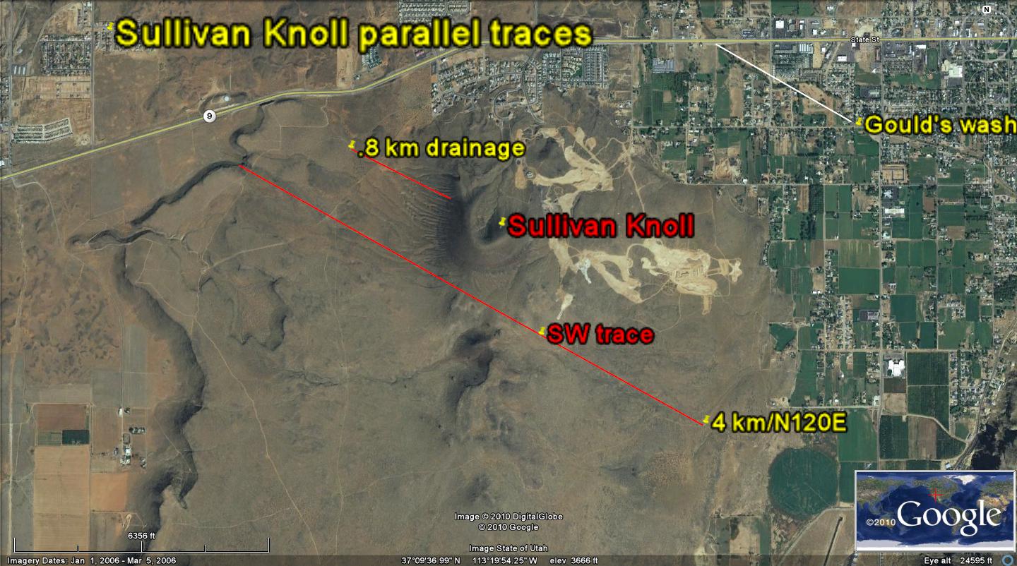 ABOVE IS AN EXAMPLE OF AN ARCUATE COVE, WITH A DIAMETER OF 20 METERS, AND ONE OF THE SMALLEST FOUND; POSSIBLY IT RELATES TO THE PRECESSIONAL ROTATION.

I have only used the various lineaments for orientation of movements made by the wall rock, but there is a tremendous amount of information inscribed on it. Firstly, the linear movements were diverted by rotations occurring outside the main basalt mass. I interpret that there have occurred minor asteroid strikes as the lineations were made; this caused temporary rotations which terminated- leaving. truncations.
Secondly, there occur ORTHOGONALS which indicate stresses from two principal directions; these represent orbital rotations of at least two types: likely Milankovitch 100 and 40k year shearing of the CRUST.
Thirdly, there were individual punctuations, such as can be seen in the Pacific basin as seamounts; these represent singular occurrences, such as might happen with lightning or small asteroid strikes.
TRY YOUR HAND AT INTERPRETATION- FIND SOME KNOWN CIRCUMSTANCE WHICH MIGHT CORRELATE WITH THESE (BUT FIRST YOU MUST HAVE A TIME SCALE, AND THIS CAN BE FOUND BY THE USE OF ROCK RINGS- SIMILAR TO TREE RINGS, IN THIS CASE SILICATES RATHER THAN ORGANICS). SEE IF YOU CAN DISCERN A PATTERN OF GROUPS OF 16 SEPARATIONS-WHICH I HAVE FOUND REGULARLY OCCURS IN THE CRUST- separating two events.
DIAMETER: EDGE GRID SPACING RATIO IS CRITICAL for AGE DETERMINATION of volcanoes and associated rotations.
Reviewing, we have found as the discovery feature, that the 50:1 ratio for:
1. AXIAL CYCLE OF MILANKOVITCH is confirmed. It occurs for the Pacific transforms, where 50 x 7.2 degrees latitude x 60 nm/degree x 1.85 km/nm= 40K km- the circumference of the EARTH, and for many shear circles near Hf;
2. The PRECESSIONAL CYCLE has a ratio of 30 or 20, BDM (smallest shear circle) but this must be confirmed. There have not been many cases of this 23-25 k.y, rotation, and this may be because the arcuate feature is smaller in trace patterns in rocks. This must be documented with additional cases:
3. The ELLIPTICITY CYCLE of 100 k.y. is elliptically shaped, and the dually-measured radius must be > 1.2 for doubt to be removed. However “which of the two radii and their respective ratios is to be used for both identification and AGE CALCULATION“? CLARIFY THIS, WITH MORE DOCUMENTATION:
4. CYCLES OF GREATER AGE, such as the million year cycle, have been tentatively measured as having a ratio of 1000, and this seems accurate- particularly when the cycle of the earth about the sun requires 1000 seconds to make a complete gravity wave transit (300 M km).

NOTE: Behind all this speculation is the BINARY SERIES, and the arrangement of strikes using this dating system. The series of 1, 2, 4, 8, 16, 32, 64, 128, and 256 m.y. has corresponding asteroid extinctions at 32, 64, 256, and possibly that at Miocene age 16, so that my intuition calls for these ages to be approximated by the independently-measured 32, 65, and 251 m.y. events measured by radio dating. This intuitive approach is documented by the harmonics of the gravity wave: circumference ratio of the solar system, and by the approximate ratios of elliptical:axial:precessional cycle times of 100,000:40,000:25,000, or 4:1.6: 1.
Another doubt surfacing is the calculated westward tidal progression of 2 cm/yr. When this is measured along a E-W line, there is the doubt that the long-term slowing of the earth of 20 seconds of time (5 nm or 9.25 km) each million years interferes with my assessment. This can be offset by use of N-S measurements, such as along Hf, and at the Equator, where the movement is N-S; but measurements of cycles are in two dimensions ,and uncertainty is involved. Further, there is the additional tidal SUN TIDAL influence, which adds to the 2 cm/yr. an additional 10 mm/yr. and I am not sure when this applies. It should always “crop up“, but the case of the Washington fault separation of 20 km from Hf seems to indicate NOT. Consequently, we must document sufficient cases to minimize uncertainty!
ONE CHECK ON THE RATIOS MAY BE MADE BY DETERMINATION OF THE CYCLICITY OF THE RATIOS THEMSELVES. This would be according to 20 (precessional), 40 (AXIAL), 80?, 100 (elliptical), 200?, 400 (ecliptic-elliptic), 800 (Sun: Earth-Moon spacing) 1000 (light transit about Sun)- SERIES TO BE DETERMINED.
CASES ARE SHOWN BELOW, WHICH WILL AUGMENT THOSE ALREADY KNOWN FOR RATIOS OF CYCLE DIAMETER:EDGE SPACING GRIDS:
 SUTTER BUTTES EXHIBITS A RATIO OF 20, AND THE LITERATURE INDICATES THAT THE EQUINOX CYCLE VARIES FROM 21 TO 26 THOUSAND YEARS (ACCORDING TO INFLUENCE OF JUPITER AND SATURN). THEREFORE, WE MIGHT HAVE EITHER A 30 OR A 20 RATIO, ACCORDING TO THE ORBITAL POSITIONS OF THESE PLANETARY ORBITS; MY ERROR FOR THIS ENTIRE MEASURING PROCESS IS ON THE ORDER OF 7% AS I HAVE CALCULATED FOR THE VICINITY OF BOTH SUTTER AND Hf:

THE pROSETTA STONE
There is, as always, a discerning MUSE
Which is the bearer of good news.
She is NOT ERATO, who governs men
But EUTERPE, who is Mother hen
Of lyric poetry and delightful verse
Who presides over something much less worse
Than our slightly lower regions-
Which have been known to defeat large legions.
She turns to stone, for our amusement
The inner workings of confuse-ment
So that EARLY loss to ANTIQUITY
Displays young PRECESSION and Obliquity.
She also loves the ELLIPTICAL witch
Which, of late, revealed by MILANKOVITCH,
Resolved to organize our universe
In beautiful Scans of flowing verse.
She froze all this in silicate stone
So that GEOLOGISTS would constantly moan
That all would have to be classified
In categories suitable for intellects ossified.
Harold L. Overton