


Above is a map of the area east of the Hurricane fault. The important features are designated, so that a hiker can access the Diamond Ranch and adjacent basalt flow. Take hiway 59 from Hurricane town, and make a right turn onto the first gravel road above the Hf cliffs; this is toward the Diamond Ranch (there is a hiway sign)- which is about 2 miles from the paved road 59 to Colorado City. Continue past the Ranch, until crossing a basalt-filled arroyo, which is a spur of Gould’s Wash. One can stop at the arroyo road at the left, or take the next ranch road to the left- which will pass the obvious crater and flows. Hike on public lands using the closest approach to either of these. The drainages have the cleanest and most information-filled outcrops on display. Below are photos and Google Earth views of closer features:


There is a bi-furcation of Basalt cones, Craters, and Vents about Hf: older to the east and younger to the west. Previous submissions on this blogsite have shown that an asteroid strike in the Indian Ocean initiated the EXTRUSIONS PRECEDING Crater Hill on the Kolob of Zion NP (probably a fragment of the Eltanin Antarctica strike of 2.15 m.y.). This started as a spiral about the rise now seen at ZNP- which proceeded to encircle the park and terminate at the Laverkin sink and graben on hiway 9 above the town. Other extrusions west of this location followed. Mt. Trumbull to the south is well known as an earlier Miocene event. It's best not to extrapolate outside of the Grass Valley-Virgin River-Horse Valley-Fort Pierce wash with observations for extrusions related to the 2 m.y. event.
There are at least 3 sites with older volcanic protrusions:The ZNP spiral yielded some interesting information about the progression of a spiral about its central uplift. Although the rate of movement along its boundaries is near 1 mm/year, the “RIP” diagonally-upward is much faster than this. Using the distance around the spiral- as measured by Google Earth distance tool- and taking the earliest volcanic age measurement of 1 m.y. in the Kolob highlands, a rate of rip can be calculated. This is 200-300 mm/year, as distinguished from the horizontal or lateral yearly movement. Visualize a sheet of paper being ripped upward, and you can see that the upward movement can be equal to the lateral tear, with hardly any lateral movement (but fast uplift). A lot of lateral movement accompanies a series of upward movements. I assume that this is due to the acceleration of the tendency for daily TIDAL MOVEMENT WESTWARDLY to be relieved in strain (thrust or linear shear) by a jolt provided by an exterior force- AN ASTEROID STRIKE. This is shown for the Zion spiral, which appears to be circular about the central vulcanism. This photo is NOT to indicate that there is a magma as wide in diameter as the ZNP. Rather, the mound is formed by an asteroid on the opposite side of the earth (found as a depression in the Indian Ocean)- which creates HEAT OF FRICTION AND VULCANISM expressed as a vent or extrusion at ZION NP (and its associated protuberance or protrusion). Incidentally, the calculated rate of “rip” of 200-300 mm/year yields a cyclicity at the Laverkin graben of about 2000 years, when the actual distance is measured on a digital photo and when divided by this approximation. This is near the cycle of Tecumseh’s comet- of about 3065 years, and my measurements and calculations are probably no more accurate than this. NOT TO WORRY- THE COMET WILL NOT APPEAR UNTIL 3065 Years FROM ITS LAST SCARE AT 1811 AD, OR DURING 4876 AD.(However, there are several other cycles which yield disturbances closer to our time).
1. Crater Hill fore-runners (to the north) of this ZION NP prominence;
2. Divide and Grass Valley extrusions surrounding Hf at a divide in the topography 8 miles south of Hurricane, UT;
3. Diamond Ranch flow and crater (my nomenclature) near the local ranch along the Gould's creek containing the basalt’s latest flow. We will investigate this flow to determine which anomaly in the shear pattern this one connects.


The spiral above is fairly-well recognized, but this is not the case for older features. Evidently, interference of subsequent movements erases or obscures the imprint of a spiral, and it is not recognized as well as younger ones. This whole analysis indicates that 2 million years (the length of the ICE AGE, and creation of recognizable wobbles in the San Juan de Fuca channel, as well as those on Sand Mountain, UT) are not erased quickly.
The intent of an investigation of the Diamond Crater and its 2 extrusions is to determine whether there are recognizable cycles and movements on this earlier extrusion. First, is there a recognizable spiral? Secondly, is this feature still under the influence of the 2 m.y. strike? The basalt flow in the creek must be the latest one, since lower-in-elevation flows are known to be younger than those higher. The reason for this is that basalt erodes slowly, compared to sedimentary sandstones- leaving a mesa, for older flows. The flows follow the ancient creeks, and in this case the creek is the one with present drainage, in spite of the basalt creek bottom- which has been laid along the same shear course as was the preceding flow. To understand this you must accept the following findings:
1. Creeks form where there is shear, where rotations have opened the crust for rapid erosion;
2. The shear occurs due to rotation of the crust, where Coriolis circles form around linears or thrusts created by westward-shove of shallow crust Due TO EARTH TIDES;
3. ROTATIONS ARE CCW, WHENEVER THERE is UPLIFT, AND THE OPPOSITE IS ALSO TRUE- CW FOR DEPRESSIONS, SINKS, AND BASINS;

and,
4. Asteroids create sinks or craters as they strike, and later create a mound or uplift on the opposite side of the earth- the ANTIPODE. We will determine if this has happened for Diamond Crater.


I WILL TRAIPSE IN FROM THE SOUTH, HOPING TO SEE SLICKENSIDES ON SEDIMENTARY ROCKS OF THE MESOZOIC. IT IS DIFFICULT TO FIND THESE ON BASALT, BUT I HAVE FOUND THEM- AS IRON STAINED AND STRIATED MARKS ON SILICATES. THE MOST VALUABLE FEATURE IS TO FIND LATERAL PARALLEL LINEATIONS (WITH MORE OBVIOUS VERTICAL ONES) SHOWING THE DIRECTION OF ROTATION OF THE COOLING LAVA. THERE IS ALWAYS A HORIZONTAL COMPONENT ACCOMPANYING THE VERTICAL DISPLACEMENT. SEE BELOW:
 BELOW IS MY ANALYSIS PRECEDING ACTUAL FIELD WORK (DIGITAL PHOTOS MERELY SCAN THE PERIMETER):
BELOW IS THE DIAMOND FLOW MAP, WITH IMPORTANT FEATURES SHOWN. THIS WAS HIKED AGAIN, NEAR THE KOKOPELLI GOLF SITE. THERE ARE GOOD ASH-COVERED ROADS, WHICH CAN BE ACCESSED DIRECTLY FROM HIWAY UT 59, AVOIDING THE DIRT (AND POOR) ROADS ON THE SOUTH SIDE OF BOTH OLD AND NEW FLOWS.


TALKING TO NATIVES AT THE GOLF CENTER, WE FOUND THAT THE GOULD'S WASH WAS PREVIOUSLY KNOWN AS "RATTLESNAKE DRAW" BECAUSE OF FREQUENT REPTILES FOUND THERE IN GOOD WEATHER. I CLIMBED THE "RATTLESNAKE" CRATER- THE OLDER OF THE FLOWS- AND FOUND THAT IT WAS USED FOR CLINKER OR RED ASH FOR ROADS. THE SLICE SHOWN ON GOOGLE EARTH WAS NATURAL, BUT AUGMENTED BY ARTIFICIAL EXCAVATION OF "ROAD METAL". THE EXRUSION WAS ALMOST ENTIRELY PEBBLE-SIZE CLINKER OR LAPILLI, AND THE N-S SLICE ORIENTS TOWARD A SADDLE IN THE SMITHSONIAN BUTTE TO THE NORTH. THIS HELPS TO DETERMINE THE REASON FOR THE CONFLICT IN ROTATION, WHICH DETERMINED THE INITIAL EXTRUSION. I ASSSUME THAT THIS 2ND FLOW OCCURRED AS A REJUVENATION CONE FROM BRITTLE ROCK, FRICTION-PRODUCING, HEAT WHILE THE OLDER FLOW ROTATED CW AS IT COOLED. WE'LL CHECK THIS BY LOOKING FOR INTERFERING SHEAR CIRCLES TO THE NORTH. I WILL ATTEMPT TO MEASURE THE AGE OF THE OLDER FLOW, SINCE IT "MUST" HAVE OCCURRED POST-2 M.Y. ZION SPIRAL FORMATION- OTHERWISE MY THESIS OF THE ENTIRE ENTITY BEING FORMED BY ROTATION OF ZION CCW FROM A 2.15 M.Y. ASTEROID STRIKE IN THE INDIAN OCEAN WILL BE JEPARDIZED.
THE EXTRUSION WAS LARGELY GAS-FILLED CLINKER, AND THIS CONTRASTS WITH THE YOUNGER BASALT FLOWS TO THE WEST (NOT QUITE AS LIGHT AS PUMICE). THIS DETERMINES THAT THE RED LAPILLI CONE IS THE YOUNGER, COMPARING THIS EVENT TO THOSE ON HAWAII, SINCE THE HEAVY BASALT WOULD HAVE BEEN EXTRUDED FIRST, AND THE MORE SILICEOUS FLOWS AND BLASTS SECONDARILY. FROM AVERAGE LATERAL MOVEMENT RATES OF NEAR 1 MM/YEAR, THE AGE IS NEAR .2 M.Y. THIS MY BE CHECKED WITH UGS MEASUREMENTS, BUT I DIDN'T GOOGLE IT. I WILL HAVE TO ENSURE THAT I HAVE THE CORRECT CRATER, BY HIKING ALL OF THEM:
 GOOGLE EARTH HAS HINTS AS TO WHERE SLICKENSIDES MAY OCCUR: PREFERENTIALLY, ALONG THE CREEK BANKS ON THE UPTHROWN SIDE OF CCW ROTATIONS (NOTE CURVATURE ON THE NORTH SIDE OF GOULDS WASH); BUT WE CAN SEARCH FOR IRON-STAINED STRIATIONS ON BASALT PARALLEL TO THE RIVER. SHEAR OCCURS ALONG THE RIVER (WHICH DETERMINED THE EROSION PATH), AND THE LATERAL MOVEMENT WILL BE BEST SEEN IN THE CREEK BED. BUT SLICKS WILL NOT BE RAISED TO VIEW, UNLESS THERE IS AN UPLIFT TO EXPOSE THEM:

CLIMBING THE RATTLESNAKE CRATER (YOUNGEST), A VIEW OF FAULTING, RED ASH, AND THE KOKOPELLI GOLF COURSE YIELDS A BROAD VIEW OF THE VALLEY AND RISES NEARBY:

GOOGLE PHOTO BELOW IS A START IN UNDERSTANDING WHY THE VULCANISM OCCURRED. THERE IS A GREAT SHEAR CIRCLE UNDER GOULDS WASH (WE WILL SEEK SLICKENSIDES ALONG THE UPTHROWN BANKS OF GOULDS WASH). THIS SHEAR ALLOWED THE CREEK TO FORM (BECAUSE OF THE FRACTURES AND LATERAL FAULTING PATH), AND LATER DETERMINED THE PATH OF THE BASALT FLOW- LIKE WATER MOVING DOWNHILL. WE CAN NOW USE THE RATE OF SHEAR TO DETERMINE THE AGE OF AT LEAST ONE OF THE EXTRUSIONS. NOTICE THAT THE GOULDS PATH HAS SEVERAL MINOR ROTATIONS OR DIVERSIONS, AND THESE HAVE INFORMATION TO IMPART. WE START WITH THE LARGER FEATURE, CREATING THE SHEAR AND HEAT OF BRITTLE FRICTION:

I HAVE ADDED GOOGLE EARTH LATITUDE LINES, SO THAT FEATURES PARALLEL TO WESTWARD TIDAL-SHOVE CAN BE APPRAISED. ANY PROTRUSION WHICH ROTATES CCW, CREATES RIGHT-LATERAL FAULTING, AND THIS IS THE CASE WITH MAGMA RISING. THERE IS A TILT OF THE CRUST AT THE EDGE OF THE SHEAR CIRCLE FOR THIS CASE, SO THAT THE DIP OF SEDIMENTARY BEDS MAY BE DETERMINED WHENEVER THE CONCAVITY OF THE ROTATION ACROSS A CREEK MAY BE SEEN (ON GOOGLE EARTH, OR WITH DIGITAL PHOTOS OF SUFFICIENT COVERAGE):
 ABOVE, THE BASALT FLOW IS ROTATING CW, SINCE IT HAS COOLED OVER A LONG TIME PERIOD- SINKING. THE RIGHT-LATERAL RULE (RISES ROTATE RIGHT-LATERALLY) IS VIOLATED IN THIS CASE, BUT WAS CORRECT FOR THE ORIGINAL RISE. IT APPEARS THAT CORIOLIS FORCE IS SUBVERTED BY THE STRENGTH OF THE ROCK- THE EASIEST PATH IS ONE WHICH HAS PREVIOUSLY OVERCOME ROCK STRENGTH. CONCAVITY IS TO THE RIGHT, THE BASALT SHEARED OBVIOUSLY ACROSS THE WESTERN PORTION, AND A FAULT CAN BE TRACED TO THE NORTH. WE WILL TREK IN THE FIELD TO FIND ANY SLICKENSIDES OR STINKING ZONE WHERE THE BASALT IS CURRENTLY BEING SHEARED. THIS WILL BE A TEST CASE FOR FAULT REVERSAL, CW ROTATION, AND BASALT AGE- WHERE THIS EAST FLOW SHOULD BE THE OLDEST OF THE EXTRUSIONS.
 THE FOLLOWING DIGITAL PHOTOS AND AN OBLIQUE VIEW OF GOOSEBERRY MESA INDICATES THAT THE SADDLE IN GOOSEBERRY RESULTS FROM A LATERAL MOVEMENT (FAULT OR LARGE FRACTURE) TO THE NORTH- WITH ROTATION AROUND THE LINEAR EXPRESSION:

 NOTE THAT THE RULES I FORMULATE PERTAIN TO SMALL AS WELL AS VERY LARGE ROTATIONS OF THE CRUST. VIEW THE CIRCULARITY OF THE YOUNG DRAINAGE TO THE NORTH OF THE BASALTIC MOUND.
 AN OBLIQUE VIEW IS SHOWN BELOW, FOR INDICATIONS OF FURTHER FIELD WORK:
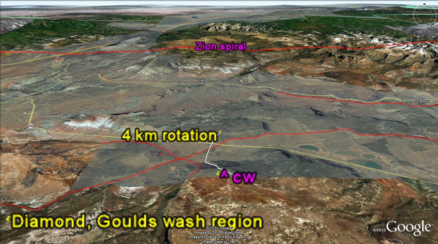 BASALT KNOB, BELOW, WAS NOT THE OBJECT OF THE PHOTO; BUT IT ILLUSTRATES THE RIGHT LATERAL RULE EXCELLENTLY- RISES ROTATE RIGHT LATERALLY:
  BELOW IS A PREVIEW OF FUTURE WORK; I MUST TREK ALL OF THESE ANOMALIES, SINCE THE GEOLOGY CULTURE WILL SEARCH FOR EVEN THE MOST MINOR ERROR- WHICH WILL GIVE THEM EXCUSE TO IGNORE THE ENTIRE ANALYSIS.
 WE WILL START WITH THE HURRICANE FAULT, Hf, AND MOLLY'S NIPPLE- WHICH IS THE MOST OBVIOUS WELL-PRESERVED EROSIONAL REMNANT OF BASALT FLOWS (NOTE THE REACTIONARY CELL, RC, WHICH HAS BEEN "DRAGGED" BY THE GOULD'S WASH CIRCULAR SHEAR PATH:

ROTATION OF THE LITTLE CREEK MESA IS INFLUENCED BY THE SADDLE IN THE Mz MOUNTAIN, KNOWN AS "THE WATCHMAN", AND WE WILL DETERMINE HOW THIS BECAME THE EAST BOUNDARY OF THE FEATURE:
 THE WEST SIDE, NEXT TO Hf, GIVES A NEW INSIGHT CONCERNING "DRAGGED" ROTATIONS- SUCH AS THE GOULDS CIRCLE. NOTE THAT THE DIAMETER IS 50 TIMES THE SPACING OF FRACTURE SEPARATIONS- AS SEEN ON GOOGLE EARTH:
 BELOW ARE SHOWN SLICKENSIDES FOUND ON VALENTINE DAY, 2011, WHICH WERE TAKEN FROM A DIKE WITH FRACTURES ORIENTED NW-SE ON THE SOUTH SIDE OF AN EXTRUSION NW OF KOKOPELLI GOLF (NORTH OF GOULD WASH), ESTIMATED TO BE NEAR 1 MILLION YEARS IN AGE. THESE ARE COMPARED TO ONE FOUND ALONG THE HURRICANE FAULT IN SANDSTONE. NOTE THE IRON FACING AND THE DIAGONAL STRIATIONS:
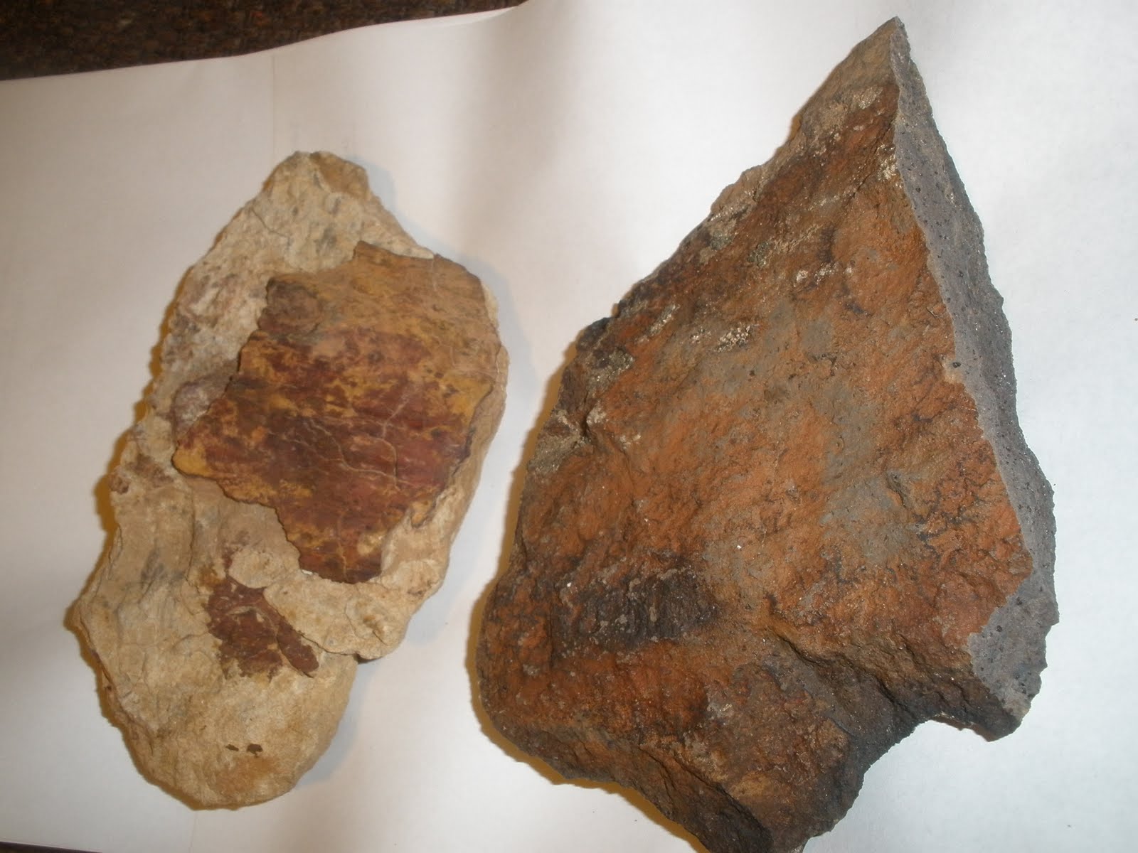
ANALYSIS OF THE CIRCULAR DIKE DIAMETER, TO FIND THE EXTRUSION LOCATION OF THE MAIN VOLCANO, WAS MADE FOR TWO LOCATIONS WHERE THE SLICKENSIDES WERE FOUND:
 THE FURTHER WEST EXTRUSION SITE HAD TWO VENTS OR DIKES, AND FORMS AN ELLIPTICAL TRACE ON GOOGLE EARTH. USING MY AVERAGE SHEAR RATE OF 1 MM/YEAR, THE AGE IS NEAR 1 MILLION YEARS: