Earth TIDES would have been LESS before this Time, near Sun's 10 mm/year (10 km/m.y.).
SIMILITUDE with Moon's 3.8 cm/year increase of SEPARATION, with 10exp10 RATIO, yields 15 meters/year for EARTH'S Movement away from the Sun! Displacement/Earth Tide RATIO= approximately 1000. Investigate the 15 mm/year TIDAL RATE, for the Period before the Moon's Fatal BULGE!
Sutter Buttes, CA, in the Central Valley, is a LaGrange Feature which can be hiked and VIEWED CLOSEUP! It is an EXOTIC EXTRUSION, never explained by Geologists, since it had outpourng of Basalt Greater than 1 m.y. AGO, in a BASIN appearing to be monotonous. It DEMONSTRATES LaGrange HEAT GENERATION at an otherwise STATIONARY LOCATION (which is Point #1 of the Lagrange 5 point Mathematical ARRANGEMENT, HEAT being generated by the friction of Moving Crust adjacent to a Stationary EMISSION POINT). Points 4 and 5 form a LINE or linear- shown as a CONTINUOUS OUTCROP or line of SHEAR. This is shown below as a RED LINE with 2 pink lines, to present an EQUILATERAL TRIANGLE, with 55.555 km SIDES:


The AGE may be CALCULATED from the Distance traveled, since the Vulcanism: Sine 60 x 55.555 km= 48.125. This DIVIDED by the Earth TIDES RATE (29.22 km/m.y.) = 1.6466. This COMPARES with 1.6 to 1.8 reported in the Literature! I started with 5 SIGNIFICANT FIGURES and consider 1.646 m.y. Sufficiently ACCURATE!
Now proceed to a LARGER TREATMENT of the LaGrange Mathematical ANALYSIS:


ABOVE MEASUREMENT should terminate at 60N, and the third TRY is shown below:

RE-MEASURING from 60N:

This EQUILATERAL TRIANGLE Side of 16,000 km terminates at LOCATION Shown:

LOCATION shown is NOT for AYERS ROCK, but we are "homing in on the CORRECT LaGrange Latitude and Longitude"! For an INDEPENDANT VIEW:
TRIGONOMETRY of the LaGrange TRIANGULAR DISPLAY requires that the Latitude be an EVEN FRACTION of 90 degrees! The Largest EQUILATERAL TRIANGLE must have CRATON Latitude COORDINATES of 24S for Australia, 60N for Hudson Bay, and 84S for Antarctica! Checking, 144 Latitude degrees x 111.111= 16,000 km (40,000 circumference/360 degrees), on a N-S Meridian. This distance must be at the SEPARATION of the Ayers Rock (VICINITY), with both Latitude and Longitude COORDINATES NECESSARY! Below is shown ANTARCTICA, to determine the Longitude of the TRIANGLE CORNER at 84S Latitude:
Second TRIAL:

SEPARATION is 16,000 km from Hudson Bay at 60N, 79,6W to 84S 91.934W at an ANGLE of 182.18 degrees. This DEPARTURE from N-S is 2.18, or the Moon/Sun RATIO= 2.16 (AVERAGED for 6 cases). There are now 2 sides of the LaGrange TRIANGLE, each of 16,000 km, and the REMAINING SIDE is determined by the ANGLE shown at Hudson Bay.

Hudson Bay, with COORDINATES and ANGULAR CHANGE between the two 16,000 km SEGMENTS is shown again; the CORNER ANGLE is 60 degrees, and this is SENSITIVE to the Starting Point on Google Earth, because of the 2D presentation of a 3D Measurement:

Then to Australia, near Ayers ROCK:

ENLARGED AREA:

To the Sahara 24N 16,000 km, at 11.8415E Longitude/278.38 degrees by COMPASS:

ENLARGED:

Not SIMPLE to place the Larger LaGrange TRIANGLES, but several RULES to follow:
1. OLDER-LARGER Triangles should ENCLOSE the smaller;
2. Use COMPASS ANGLES from the same STARTING COORDINATES, otherwise it will be unintelligible!
3. LARGER TRIANGLES have a Latitude EVEN NUMBER, (e.g. 40N ) with the Longitude at a SIMPLE NUMBER from the 169.6 Natural Prime MERIDIAN, e.g. 176.6W is 5W of the Reference; and,
4. 16,000 km DISTANCE is the Primary factor to ensure, then find an EVEN Latitude at a 60 degree ANGLE from the Original, then Measure the Resulting Longitude (it will be HELPFUL to find the Simple number from the Prime Reference!).

RED TRIANGLES increase in SIZE with TIME, and this is shown ABOVE, as MULTIPLES of 111,111 km SIDES!
South Atlantic has the MAR younger to the NORTH, as shown by the following TRIANGLES:
 OLDER TRIANGLE (Larger) to the South:
To OFFSHORE South America/16,000 km/132.27d:

ENLARGED:

Measuring 16,000 km/271.47d, BELOW along Eastern BLUE LINE to Mauritania 20N 16.669343W:

LaGrangre TRIANGLE from Mauritania to Australia CRATON encloses the South Africa Focus, which is 8000 km from Western Australia:

CURVATURE of the Earth requires that an ALLOWANCE be made for departure (using Average Angle or Direction)!
TRIANGLE is shown for angles at CORNERS:

Above, the APPROXIMATE Location of the Focus of the 16,000 km TRIANGLE is located at 24S 124.4E, 66W of the Prime NATURAL Meridian. The Triangle is located VISUALLY, by the recognition of 60 degree ANGLE CHANGES at Corners! 24S "fits" the necessity for Exact FRACTIONS for the Latitudes (180/24= 7.5), and the Longitudes are REFERENCED to 169.6W Longitude- the "Zero" for the Natural Longitude Meridians!
DIFFICULTY of finding the RIGHT Distance, simultaneously with an EVEN Latitude is shown for the South Africa CRATON and the Aleutian SPIRAL:

The 16,000 km "Line" is shown at 22S 21.433511E, above and ENLARGED AREA below:

To the Aleutian SPIRAL, 16,000 km, 2 Trials in PINK:

Above shows the POSSIBLE ERROR, when only an EVEN LATITUDE and the 16,000 km Distance are used for the search!

Lagrange TRIANGLES must be found VISUALLY, since Google Earth yields INCORRECT measured angles when approaching from different directions!
60 degree angle SHIFTS are required to form an EQUILATERAL TRIANGLE for the Lagrange STABLE and unstable "Top of the Hill" Locations:

ORB Focus and Center LOCATION:

FINAL Location of the Center of ROTATION lies at 24S 124.4E, which is at 7.5 ratio Latitude and 66W of the Prime NATURAL Meridian.
Taklimakan DESERT has a 8000 km LaGrange EQUILATERAL TRIANGLE:

BIG PICTURE of the TRIANGLE:

NOTE! In Surveyor's Parlance, the Survey "does NOT Close!". There is a small ERROR on the NE Corner! This is SIMILAR to the Partial FIGURE 8's ERROR, where a PRECESSION or other IMPRECISION has intervened, to PREVENT CLOSURE! NEVERTHELESS, the LaGrange TRIANGLE allows SOLUTIONS of features NOT UNDERSTOOD by Geologists!
The 90E Ridge is shown below:

The 90E Ridge is on a 3333 km SIDE Triangle, for Ratio of 16000/3333= 4.8, or 10,000/3333= 3 (Siwa ASTEROID):

ENLARGING the Area:

Above TRIANGLE is a First TRIAL, and should be more carefully measured! The NORTH Side is still being developed, and the TIME INTERVAL for completion is 3333/16, which is Greater than 200 m.y.

You should ask: "How can you FORM a Triangle with only one line?" Two features determine LARGE LaGraange Triangles:
1. The Straight LINE length is a MULTIPLE of (40,000 km/360 degreees=) 111.1111 km, since this is an Even Division of BOTH 10,000, (90) and 16,000 km (144)!
2. Latitude will be an Even Number at one END of the LINE (possibly Both Ends).

ERROR is Significant, using 3333 km, 2 Even LATITUDES, and a Calculated TRIANGLE!

RECALCULATING, with only one EVEN LATITUDE COORDINATE, SW Corner

Above 3333.3 km LINEAR fits the TRANSFORM, using ONLY one Even Latitude Coordinate:

Above TRIANGLE fits the TRANSFORMS, and the only CHECK is on the SHIFTS along the LINE ADJOINING the Islands. First DIVIDE the Triangle, to find the TRANSFORM FRACTIONS:

LARGER 888.88 km TRIANGLE

COMPARING with the Aleutian SPIRAL:

A SPIRAL is exhibited EAST of the ARCUATE Ridge- ORTHOGONAL to the ALEUTIANS:

NORTH, arrow UP:

CLUE shown is the 4 tenths Ratio of the ESTIMATED FOCUS to the 6000 km Lagrange SIDE:

Using the Sine 60 degrees= .866 x 6000 km= 5196, with RATIO of 2450/5196= .47, and this is still LARGER than Ratios to the South. This is a CLUE to a Latitude INFLUENCE! The 40N Latitude is a MAJOR DIVISION of the Earth, as noted by the LACK of TRANSFORMS to the North of this Parallel! It marks the WESTERN-MOST Jut of the smaller Orb, but is not western-most for Canada, with the LARGER ORB (CRATON also). The Figure 8 begins at Puget Sound, with its DIAGONAL to the NW, and 48N Latitude!
Placing a WHITE LINE at the HALF ANGLE (30 degrees from West Side), the SPIRAL is divided in the MIDDLE! Although the APPEARANCE is Not that of a split of the LARGE TRIANGLE, this is a source of error with the 2D representation of a 3D Feature:

APPRAISING the HYPERBOLA, since it appears to be a CENTRAL Feature of the 2 LaGrange TRIANGLES:

ELIMINATING Previous data, look at the HEXAGON found from a Geographic Map of the Region:

ENLARGED, Notice the TAN Reverse S, which is an ANOMALY (being a RISING Feature):

The 4 or 5 tenths Ratio of the SPIRAL is relating that the POSITION of the Feature is related to the LaGrange EQUILATERAL TRIANGLE! This CASE, having NO Geothermal Emission at the Siberia Apex (Point #1, of LaGrange), has SHIFTED the EXTRUSIONS to the Aleutian CHAIN! Let's look at Siberia:

EXPANDING:

SE Corner of the small Triangle is the YOUNGEST, and the Feature is moving SE-ward!
This ia a NEW FINDING, that the LaGrange Vulcanism (#1 Point) does NOT OCCUR at a Triangle CORNER! Looking at the SW Corner, which is at the HYPERBOLA FOCUS:

The LOCATION in Pink occurs at 20.439N, or 20 South of Mendocino, and 174.4E, which is 16W of the 169.6W Prime NATURAL Meridian! This is at a NINTH of the Hemisphere, and 360/16= 22.5 ratio to the Circle, or .044444, the 111.111 HARMONIC! Possibly there are EXTRUSIONS in the HYPERBOLA, and this would be a REGULAR LaGrange OCCURRENCE! RATIO is 2500. 6000 km SIDES x 2500= 15 million, which is a TENTH of the DISTANCE from the Sun! This is a FOCUS between Earth at 150 and Venus at 108 million km from the Sun!
EXPANDING the HYPERBOLA, for a SEARCH:

Literature REPORTS that the Ewing SEAMOUNT is VOLCANICALLY DEAD!
This LACK of Vulcanism ELIMINATES the Ewing Seamount as a LaGramge #1 Point- that of a STABLE (Geographically) SHEARED Crustal Feature, yielding HEAT! This returns the ALEUTIAN SPIRAL to the Prominant ANOMALY, one Producing VULCANISM! Indeed, the Aleutians are VOLCANICALLY ACTIVE! Only QUESTION Remaining: "Is there Vulcanism in the Figure 8 SPIRAL?"
You should ASK: "Are there TRIANGLES in BOTH HEMISPHERES?" The ANSWER is YES:

TRIANGLES do Not Overlap, but are NEAR EACH OTHER! They are SEPARATED by 1430 km, which yields RATIO of : 16,000/1430= 11.1, near the Pacific Hyperbola:

As EXPECTED, the 2 EQUILATERAL TRIANGLE Centerlines (in White, for 16,000 km Sides), are 60 degrees to EACH OTHER! This is an APPRAISAL of my Personal ERROR!
NOTE: There is usually 2% ERROR or so, but this is MINISCULE when COMPARED to the UPSIDE-DOWN use of Mantle Plumes, or the ORTHOGONAL Wrong view presented by the Plate Theory!
RELATIVE Movements of the 2 LaGrange Triangles, are to the North for the West Block, and to the South for the East Block (including the Hawaiian Islands to Maui):

RED LINE crossing the photo is 10,000 km in LENGTH, so that it is possible that there are other TRIANGLES to the South! Wake Island 160E Meridian is the LOCUS of several ANOMALIES, and I will SEARCH this Meridian:
Nothing to the North, but ANOMALIES to the SOUTH include New Zealand:

Nauru at the EQUATOR:

Some Islands are SINKING along this Meridian, but presently this is due to GLOBAL WARMING!

There should be other ANOMALIES (HYPERBOLAS, LaGrange HEXAGONS, and Boundaties of LARGE 60 degree TRIANGLES), and Earth Scientists may contribute!
NORTH Boundary of the Indian OceanTRIANGLE:

KRAKATOA lies at the APEX of a smaller Triangle (LaGrange #1 Point), whose side is one THIRTIETH of the Side of the 90E Ridge TRIANGLE, BUT which is NOT within it- CROSSING it instead!
ENLARGING, subsequent smaller TRIANGLES indicate that the MOVEMENT is to the EAST:

The TSUNAMI of North Sumatra- Thailand killed several THOUSAND People, and is likely to RECUR! It is diffficult to describe in terms of a LaGrange TRIANGLE:

CASES, so far, indicate that LaGrange TRIANGLES are moving LATERALLY; this produces Heat of FRICTION (VULCANISM) but NOT VERTICAL MOVEMENTS! Great downward SLIDES and NORMAL FAULTING are NOT exhibited with these LATERAL SHIFTS!
New Zealand or the TONGA TRENCH is NOT on the TRIANGLE, BUT it is on another 888.8 km LINE !

Look at the FOCUS of this Feature, to determine whether it is a HYPERBOLA or a PARABOLA. The ECCENTRICITY will be the DISTANCE from the Focus/DIAMETER, should it be a portion of an ELLIPSE:

ELLIPTICITY is .045, and this has been MEASURED (Literature) for Jupiter (.06487) and Uranus (.033), with some REPORTS for EROS being CLOSER! CONCLUSION is that the EXTRUSIVE SEAMOUNTS more likely display a PARABOLA
Australia to the South America ORB:

FIND the TRIANGLE, using only the 888.8 km Distance:
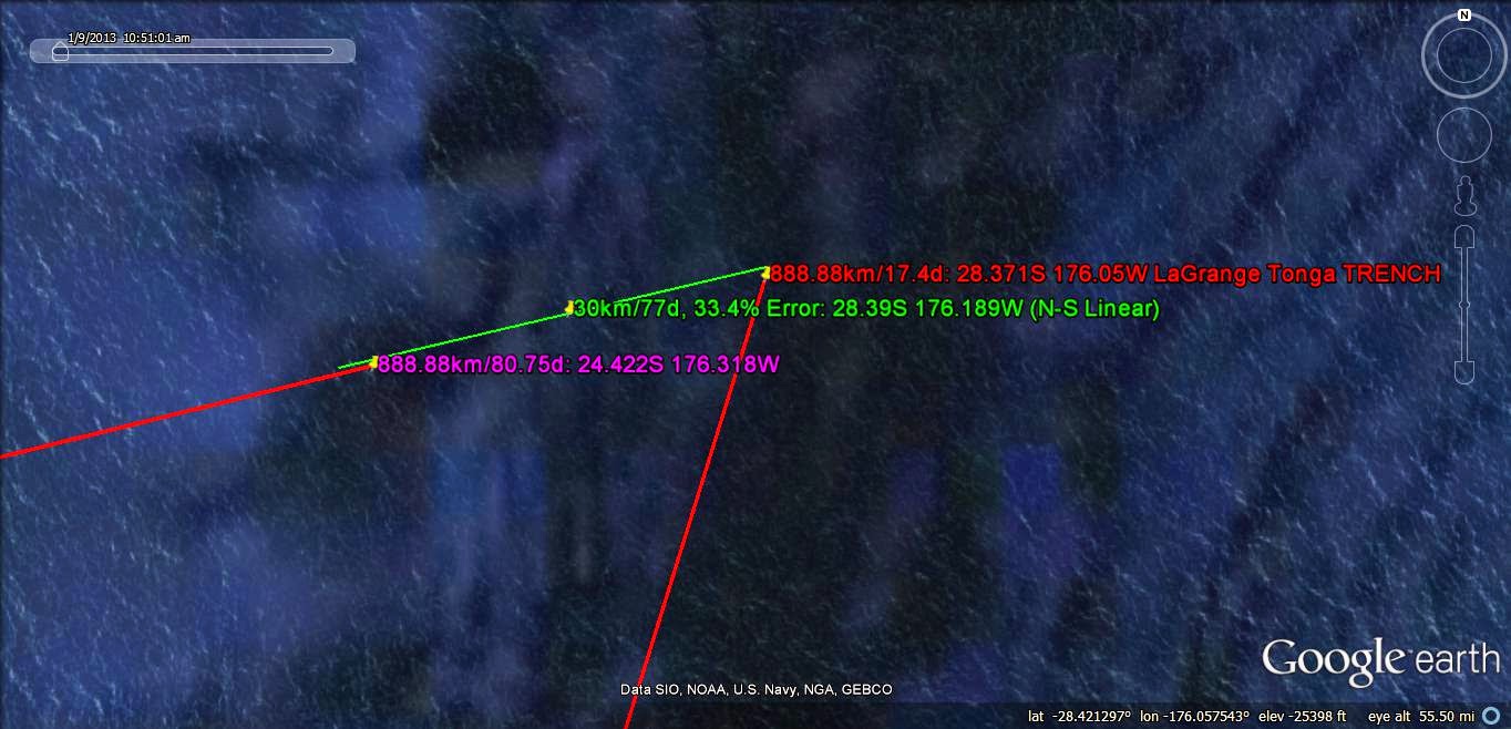
BIG PICTURE of the LaGrange TRIANGLE along the Tonga TRENCH:

NOTES about LaGrange TRIANGLES:
LaGrange determined the Relationship between Solar Masses (Planets and Asteroids) and Adjacent Bodies which are Gravitationally POSITIONED in a TRIANGULAR Configuration to each other. There are 5 points to a 3 Body Solution, and they are Labelled as follows:
1. is the Point of Coordinate STABILITY, which produces HEAT of slicing as Crust Jerks by- creating FRICTION (Vulcanism on a Large Scale, Hot Springs on a small scale), such as Iceland;
2. is a Balanced Point, between two Large Masses;
3. is a point determined by the Barycenter of the Large Mass;
4. and 5. are on Corners of the Triangle, with STABILITY, approaching a Line of INSTABILITY! This determines the Point of Drastic CHANGE!
CASES can Help UNDERSTAND this Phenomenon:
LaGrange TRIANGLE is ENLARGED for West Coast, USA:

LaGrange Point 1 is at Hawaii, 4 and 5 are along the Sea of Cortez to Mt. St. Elias- a LINE of STABILITY, which traces through the Gulf of California:

APPRAISAL along the Mendocino TRANSFORM:
Look at the TRIANGLE East side, to determine whether it fits the STABILITY of LaGrange:
Columbia River Bend at Portland, OR and the Willamette River is near the Red LINE:

Above RIVER ORIENTATION SHIFT is the most prevalent TREND found along the Red LINE. Notice the SHIFT in the Strait of San Juan de Fuca:

Mt. Olympus NE line, above, and below there is the Lake District of NV and OR:

Elliptical arrangement of Lakes is a LOCATION of recent 4 to 5 Richter QUAKES during 2014, and is SIMILAR to the 2011 Clintonville, WI "BANGS" which lie along the 90W Meridian 89.6W, more PRECISELY, (exhibiting the LARGEST QUAKE in USA recorded History- the 1811 to year 1812 New Madrid EVENT), This is a FOREWARNING of further destructive EARTHQUAKES!
Warm Springs State Park, NV:

Colorado River LEFT TURN:

Gila River Bend SHIFT:

TRIANGLE SE Corner is moving SOUTH with Time:

The TRIANGLE Enlarges as the Continent EXPANDS to N-S!
GENERALIZING, the LaGrange LINE (in RED) finds River SHIFTS of the Columbia, Colorado, and the Gila rivers, but does NOT correlate with Range orientations, or anything in the 2 to 15 million year AGE Province! This suggests that the EQUILATERAL TRIANGLE has become important since the 2 m.y. Maui Development! There is a MAJOR INFLECTION at Maui, further hinting that This FIX of the Mt. St. Elias and Southern end of Baja Peninsula at Cabo St. Lucas is near 2 m.y. AGE!
Again, the LINES along LaGrange TRIANGLES locate LATERAL MOVEMENTS (such as the Evaporitic Lakes ELLIPSES), but do NOT CORRELATE with Vertical movements!
Lake Ponchartrain, LA, near New Orleans exhibits a SINK, which is a part of the "HOLE SLICE" display. This will approach a N-S MERIDIAN, yielding the Longitude along which the LaGrange TRIANGLE side of 16,000km is shown for Hudson Bay 60N to Antarctica 84S (=144 x 111.111= 16,000 km):

ENLARGED to show New Madrid QUAKE ZONE:

The 10,000 km TRIANGLE is shown from Hawaii's East Coast to Iceland, from 20N to 64N:

The 10,000 km Hawaii ANGLE is 17.22 degrees from 20N to Iceland 64N; checking by Trigonometric Sine 17.22= .296, Cos= .95517, and 44 degrees x 111.111= 4888.88 km . I CANNOT use this method, since the Transection travels at a CONSTANT ANGLE and NOT along the Great Circle!

"BIG PICTURE" showing the 60 degree TRIANGLE formed with the Maui TRANSFORMS:

BIG PICTURE if Maui to Iceland to STABLE Borneo (Kalimantan ORB along a 10,000 km LINE in RED):

DETAIL for Kalimantan:

Great Bear Lake, Canada is "on the line". Notice the SHIFT in the ARC CONVEXITY between the 2 Lake portions:

As is Greenland at 72N 44W (which has a LAKE beneath, by Geophysics):

LATERALLY-Moving
LaGrange Transforms impinge on the 7.2 Latitude degrees (and Sun TILT) Spacing ANALYSIS:
Previously, I have found
that the Sun Tilt is 7.2 degrees, as contrasted to the 7.25 reported in the
Literature. Which pertains to the Present TIME? Above finding that the
Mendocino most Northerly Transform is YOUNGEST may be related, to yield the
answer! Question to be answered first is: “Does the Moon effect Meridianal
Changes, while the Sun effects movements along Latitude Lines? This has been my
Conclusion, so far, but let’s TEST IT with LaGrange Triangle INPUT!
Firstly, the Sun’s 7.2 degree TILT contrasts with
the Moon’s 5.145 degree Inclination to the Ecliptic Plane Literature’s 7.25-
5.145= 2.105 degrees. This is a Tilt Ratio DIFFERENCE, compared to the Gravitational
Moon/Sun ratio= 2.16, from 6 case studies, and has UNCERTAINTY as to whether
they can be Compared (2.5% difference)!
Secondly, the Mendocino TRANSFORM (which is spaced 7.2 degrees Latitude from the next
Significant Transform) obviously PRECESSES as it is followed Westerly!
Thirdly, Case studies show the Moon is the Dominant influence in the MAR in the South Atlantic,
which is a N-S movement. This is the case for Greenland and other N-S Oriented
Features. What is the IMPETUS for the Pacific E-W Transforms?
TENTATIVE CONCLUSION: Since the Triangle FOCUS is found at 40N 133.6W Longitude (which is 36E of the Prime NATURAL Meridian), and since 180/40= 4.5, an EVEN FRACTION, this finds the FOCUS, and it establishes that the TRANSFORMS are relaated to the LaGrange TRIANGULAR Feature!
MATHEMATICALLY, the Ratio: 40,000 km Circumference/10,000 km Side= 4, which is the same as the Partial Transforms of 7.2 degrees Separation/4= 1.8, which is exhibited to the South of Mendocino:
The "JERK" between Major and minor TRANSFORMS is 200 km. which requires 200/17.48= 11.4416 m.y. (a MULTIPLE of the SUNSPOT CYCLE)! This 1.8 degrees is near the 1.77d for Neptune, Tenth of the 17d for Pluto, and the Ratio of Jupiter/Uranus's Inclinations= 1.687!
Sun's 7.2- Moon's 5.145= 2.055 degrees is NOT quite small enough!
USE Neptune's Inclination above the ECLIPTIC, since there is less than 3% Deviation from 1.8! Jupiter correlates with MAJOR TRANSFORMS, while Neptune yields the FAINTER, OLDER, and more Southerly Transform.
REGULARITY is established by the TRANSFORMS, as they form TRIANGLES with Mt. St. Elias:

Finding the 888.88 km LINE to the Gorda ESCARPMENT:

Gorda to Mendocino TRIANGLE, first Trial:

Above TRIANGLE can be improved, but the Principle is established: Capes, Juts or POINTS are positioned by the FOCI or by the TRANSFORMS in the Pacific!
2nd TRIAL, in RED:

LARGE VIEW:

Mendocino TRANSFORM is the Latitude below which TRANSFORMS occur, and above which VULCANISM (Cascades) ensues! RATIO of 10,000/888.88= 11.25= 7,2 (sun) + 2.49 (Saturn) + 1.03 (Jupiter) + .47 (Europa))= 11.19 total. This is a 4 Body CASE, for 2 Planets and an Asteroid! There may be OTHER additions of the Inclination Angles which are ADDITIVELY CLOSER!
A 5555.55 km LINE occurs from Mendocino to a HYPERBOLA near the Internayional Date Line:

HYPERBOLA FOCUS suggests that the Side Length should be 6000 km, instead of 5555.55 km:

FOCUS OF THIS 6000 km TRIANGLE is at the Aleutian SPIRAL (Figure 8):

TRIANGLE is shown for a second TRIAL, to determine REPEATABILITY:

LARGER TRIANGLE SW Corner:

ENTIRE TRIANGLE:

Next is to find how the ALEUTIAN SPIRAL fits as a FRACTION of the TRIANGLE:

FRACTION of 4/10ths of 6000 Compares with THIRDS and FOURTHS further South!
OTHER ANOMALIES, 66N and the Natural Prime MERIDIAN:

GRAVITATION and
LaGrange Mathematical Relationships:
The LARGEST LaGrange TRIANGLE found on Google
Earth has SIDES of 16,000 km, and this Fraction of .4 = 1/2.5 of the Earth’s
Circumference is the Largest possible, since those larger than 19,999 km cause
INSTABILITY and impossibility of Measurement! The RATIO of 2.5 refers to a Mass
dependency, for Jupiter’s mass is that ratio to all the others in the Solar System
(excepting the Star Sun).
LaGrange EQUILATERAL TRIANGLES (with all
angles of 60 degrees, and ALL Sides of equal Length), has been solved,
mathematically for the 3 Body Case, where the Earth, Jupiter, and a Third
Satellite (Natural or artificial) are Placed in Positions of STABILITY,
Instability, and relation to a Barycenter, or three quarters of the Earth’s
Radius, in relation to the Moon’s Offset= 4600 km from Earth’s Center.
Barycenter of the Sun is also inside the Star, and these are named Point 3 by
LaGrange. The Point of most Interest to Earth is Point 1, and it is displayed
at Stable Iceland, creating Heat of Vulcanism (FRICTION against the Moving BOUNDARIES) to maintain its Stationary
Location!
Points 4 and 5 are Stable Locations, and may
be viewed on the Iceland TRIANGLE at a line stretching from England to the SW
Corner, after which there is approach to Iceland along a Linear which measures
the LENGTH of a Side.
TRIANGULAR Relationships for more than 3 Bodies
are COMPLEX, and
will be solved by cases, first involving Venus, for the 10,000 km sided
Triangle, and which calculates 16,000/10,000= 1.6, that is the IDENTIFIER for
Venus (near Earth days/Venus days per orbit. This calculates 1.625= 13/8, and
there is a Variation of Venus’s orbit to accommodate this (possibly). This case
was solved first, as the Triangle from the Red Sea, 1.2S Latitude and the North
Pole. It is LARGER than the Iceland Triangle, and assumed to be OLDER in
formation!
The next ENTITY is
that of DIMENSIONS, since the Comparison of Venus and Jupiter
notes Mass Ratio vs. Orbital Ratios! Venus is Not in the same System as
Jupiter, where 16,000 is divisible by 2.2222, yielding 7200 km and its Exact
Fractions of 3600, 1800, 900, 450, and 225. These are the lengths of Sides of
Triangles, which are expected to occur at Critical Coordinates on Earth. Venus
triangles are expected to exhibit sides of 10,000 km and its exact fractions
(Harmonics).
This Categorization reveals that the 2.16
ratio of Moon/Sun, is NOT INVOLVED, and requires that the Ratio: 16,000/2.16=
7407.407407 be investigated! It may be that the Influence of Mars has offset
this Difference between 2.222 and 2.16!
Mars must be Incorporated into this ANALYSIS,
and it should fit the Ratio: 16,000/1.88= 8510.6 km. This is the NEXT Category
of Triangles.

These TRIANGLES emphasize that there are TRIANGULAR RELATIONSHIPS (Hilda-like LaGrange ARRANGEMENTS) for the Planets EARTH, JUPITER, VENUS, and for Earth's MOON, such that ALL THESE are in SYNCHRONIZATION, GRAVITATIONALLY, with each other!
The CASES shown are the OBVIOUS ones, since they occur at WELL-KNOWN CRATONS, and Smaller Equilateral Triangles Multiples OCCUR at smaller divisions of Latitude (FRACTIONS) of the 90 degree QUADRANTS. Smaller Equilateral Triangles will be found at other REFERENCE Latitudes .
The ORDER of Importance is as follows:
1. The craton TRIANGULAR ARRANGEMENT (Pacific Ocean), with 16,000 km SIDES;
2. The Atlantic Ocean, with 10,000 km sides;
3. The China NON-CRATON, with 1290 km sides, and,
4. Others NOT-YET INCORPORATED:

Above MEASUREMENTS indicate that the Equinoctial (Precessional) CYCLE is determined also by the Gravitational SYNCHRONIZATION of the CLOSE PLANETS (to Earth)!
The TRIANGLE shown does NOT match the COASTLINE! This yields a way of COMPUTING the INTERVAL TIME since formation of the EXPANDING Triangle, via MEASURING the ORTHOGONAL SEPARATION of the Coastal ARC. Using the TRIGONOMETRIC TIDAL RATES, the AGE is as shown:

Above calculation may be CROSS-CHECKED by using one SIDE'S LENGTH: TIME INTERVAL= Distance/Tidal Rate, for the DIRECTION shown by the CONVEX ARC;

KARST Topography and TIDES:
There are 3 classifications of Tides (both
Oceanic and Earth Tides):
1. Semi-Diurnal, where water moves in
and out twice Daily- Atlantic Coast;
2. Diurnal, where there is one Complete
Cycle- China SE Coast, and
3. Mixed, where the 2 cycles, above,
display INTERFERENCE. This is the case for the West Coast of USA.
Karst, or Sinking and Erosional
Remnants’ Topography, is found in SE China (Diurnal), Guatemala, Florida- where the Moon
effects both Diurnal(Gulf side) and SemiDiurnal TIDES (Atlantic side). SINKHOLES reveal the SINKS!

OPPOSITELY, the west Coast USA, where there is westward movement, as
Noted by the CONVEX ARC to the West (opposed to China’s Convex to the SE), has
Mixed Tides, not only in almost-enclosed Resonance Basins- such as the Puget
Sound, but also at San Diego.
This infers that Reverse (Retrograde) Earth Tides are associated with KARST Topgraphy (SINKING), and that Normal WEST TIDES inflict COMPRESSION or Rising! This is done principally by the Moon, but the Sun also contributes SIGNIFICANTLY, in MIXED and SemiDiurnal Earth and Oceanic TIDES! Diurnal TIDES create ANOMALOUS Basins or SINKING!

This infers that Reverse (Retrograde) Earth Tides are associated with KARST Topgraphy (SINKING), and that Normal WEST TIDES inflict COMPRESSION or Rising! This is done principally by the Moon, but the Sun also contributes SIGNIFICANTLY, in MIXED and SemiDiurnal Earth and Oceanic TIDES! Diurnal TIDES create ANOMALOUS Basins or SINKING!
Back to China's SE Coast:

The COASTLINE shows the PREDOMINANT Tidal DIRECTION; it EXHIBITS small Bays to the NORTH, excepting for the "TIT", which is moving SE:


COORDINATES formed by the N-S LINEAR add to 90 degrees (ORTHOGONAL), yielding a method of finding OTHER TRIANGLES! However, remember that the Longitude, REFERENCED to Greenwich is ARTIFICIAL! RATIO of 2.1585 indicates a Moon/Sun INFLUENCE, for the LARGEST 16,000 km/7403 Triangle RATIO:

ICELAND is NOT the largest of the ASSOCIATIONS of RISES and SINKS with the EQUILATERAL TRIANGLES! It is included in the 10,000 km Red Sea to MAR to the North POLE Triangle, where 16/10= 1.6 for Venus, CONTRASTED with 2.16 for M/Sun! Jupiter would require a RATIO of 11.88, and a Triangle with sides of 10,000 km MAR/11.88= 841km.This LINEAR is found at Mountain Ranges, such as the Sierras. REFERENCED to 16,000km (Maximum found with CRATONS), the RATIO for Jupiter requires 16,000/11.88= 1346.8 km, which is 12.1212 degrees of Latitude. This is shown below:
INSPECT the SW Corner of the LaGrange TRIANGLE:

My CALCULATIONS yield 90+ m.y. for the Sun's TILT Precessional CYCLE! This is during the Cretaceous, when SHALLOW SEAS were offset by UPLIFT!
No one noticed that the COMBINATION of the LINEAR PORTION of MAR, the last Major TRANSFORM, and the Coast of England-Scotland create a TRIANGLE. Let's see whether it is an EQUILATERAL Triangle or other POLYGON:

There occurs only one Compass degree VARIATION from the expected EQUILATERAL TRIANGLE, and the DEVELOPMENT TIME for the West side is 182.78 m.y.! The EASTERN SIDE is much OLDER, and is RISING, as opposed to extending E-W on the West Side!
The DEVELOPMENT TIME indicates that the TRANSITION PERIOD is 80+ m.y. and this is the Sun's PRECESSIONAL CYCLE for its 7.2 degrees TILT.
The 1850 km SIDES yield: 16,000/1850= 8.65 RATIO, which is LESS than Jupiter's 11.88, indicating that ASTEROIDS' HILDA Arrangement is the Gravitational IMPETUS for this Triangle.
Although the MOON effects changes along a N-S axis, which occurs in the South Atlantic, the Sun, Jupiter, and the ASTEROIDS develop these TRIANGLES PRIMARILY in the North Atlantic!
CAVEATS: 1. The Ratio 8.65 could be 8.85, the years for Progression of the Moon, but this has a 2% error and has DIMENSIONS! Ratios, degrees, and features Relative to Earth's have NO DIMENSIONS, and I use them COMPARATIVELY, such as Jupiter's 2.5 x all Solar Mass (More than TWICE all others, except the Sun), relative to Inclinations or Orbital Years/Earth year!
2. More dimensionally-compatible is the Moon's 5.145 + 3.398 degrees for Venus= 8.543, which has a difference from 8.65 of 1.2%. This case involves The Moon and Venus!
3. The TRIANGLE shown for Iceland appears NOT to be an EQUILATERAL TRIANGLE, although measuring 60 degrees at corners, BUT THIS IS DUE TO THE CURVATURE of the Earth (2D representing 3Dimensions); and,
4. TRIANGLES should occur at EXACT FRACTIONS of Latitude, such as 24S for Australia, and this case should exhibit CRITICAL COORDINATES! These are shown below, as 60N and 150E of Prime (169.6W):

It is APPARENT that EQUILATERAL TRIANGLES indicate HARMONICS of the Jupiter-ASTEROIDS LaGrange INSTABILITIES!
Look at Hot Springs, AR, where a DIAGONAL crosses from the New Madrid SEVERE QUAKE to the GEOTHERMAL ANOMALY 444 km to SW (multiples of 444.4 are exact Fractions of 16,000 km: 36, 72, 144, 288 in the binary SERIES) ):

Above TRIANGLE indicates that ASTEROIDS yield HARMONICS of the 16,000 km MAXIMUM, and this case yields a RATIO of 36 (PALLAS) , at 36N Latitude, along the 89.6 CRITICAL LONGITUDE (80E of Prime NATURAL Meridian).
DETAIL:

A Case of GENERAL INTEREST is that of the Juan de Fuca CHANNEL, where the N-S Coast and Cascades EXTRUSIONS turn to the NW, forming a PARTIAL FIGURE 8:

ENLARGING the TRIANGLE:

Within the 183 k.y., there is WOBBLE, and this may pertain to an ELLIPTICAL + 2 AXIAL Cycles (100 + 2 x 41 k.y.), as shown by the one LONG and 2 smaller ARCS. HEAT may be produced at the BIFURCATION, shown in RED! This could be the Point # 1, calculated by LaGrange, where FRICTION in the split and from Shearing in the TURN denotes the FOCAL POINT! This Stationary CRITICAL COORDINATE of 48.433N 124.866W should denote the Start of the Figure 8 between the 2 ORBS of USA (Mendocino to Cape Hatteras), and the Canadian LARGER Diameter LANDMASS (including the CRATON)!
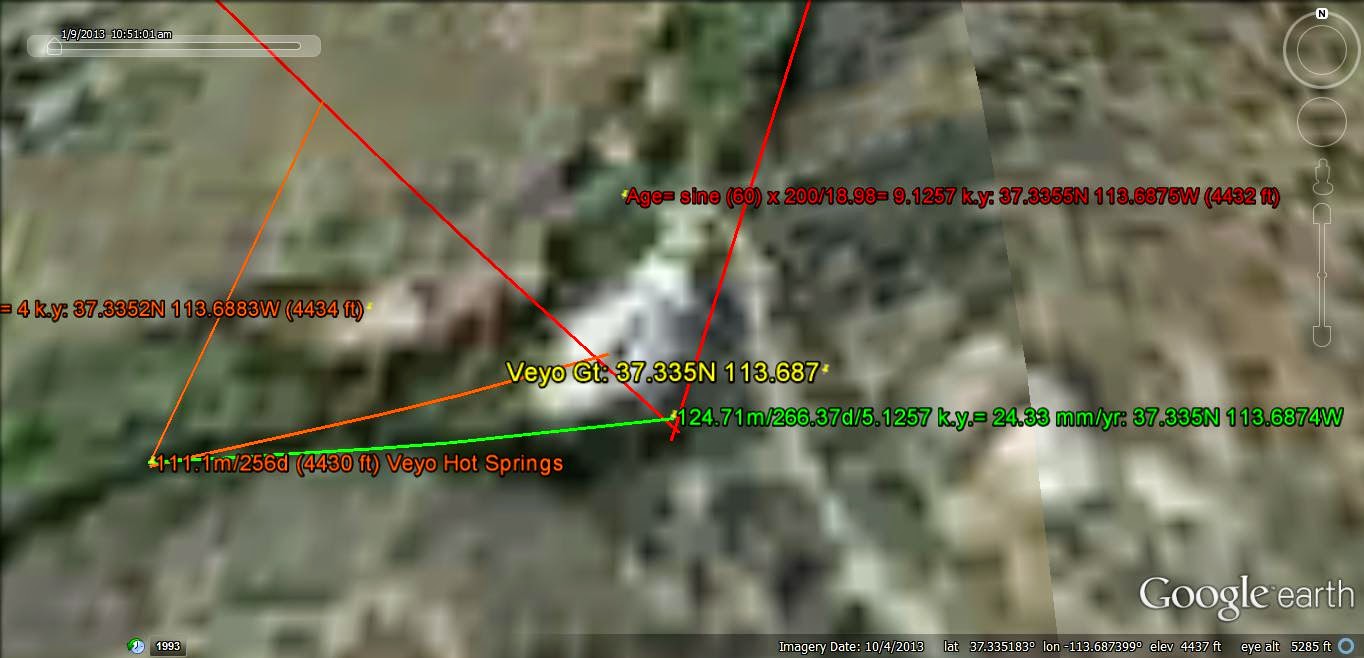
A smaller case is for Veyo Volcano, a 10,000 year EXTRUSION, with Hot Springs near the Town of Veyo. This is more VAGUE, but discernible with the TRIANGULAR LINEARS:

The RATIO of 1627 is 1000 x the year's Ratio of Earth/Venus yearly ORBIT TIMES! This SET of EXTRUSIONS lies near St. George, UT, and is the YOUNGEST of all the Santa Clara- Virgin River Valley Volcanos:
DETAIL;

OBSERVATIONS: Hot Springs and Young VULCANISM are exhibited in smaller TRIANGLES!
Below is a CASE that can be HIKED and Measured with Compass and Google Earth:

Washington City, UT has an Asphalted Trail, Starting at the Virgin River at the 300E Park. This connects with another MAINTAINED Trail leading from the Washington Parkway PARKING LOT. The 70F warm Spring is located at the INTERSECTION of three DRAINAGES, and can be accessed from either Trail!

LARGER AREA:

GOOGLE EARTH depiction:

INTERESTED Earth Science HIKERS can hike this asphalted Trail and RETURN within 2 Hours!

TRIANGLE is difficult to Visualize, since there is a SHARP ELEVATION Difference across the BASALTIC UPLIFT! This case should be DETAILED by someone able to scale the SCARPS, but first look at the DYNAMICS of the area- which incurred SPALLING CREEK BANKS 3 years AGO!
Choosing another LaGrange LOCATION from a GEOGRAPHIC MAP, for the ELTANIN Fracture Zone:

Above, there are definite TRIANGLES, but they are NOT EQUILATERAL! This MUST be RESOLVED, and it CANNOT be ignored because of it being South of the 66.54S Antarctic CIRCLE, since the 16,000 km (largest Triangle) SEPARATION occurs at ANTARCTICA!
I'll EXPLORE the possibility that the Antarctic Continent was under the INFLUENCE of the Sun (north of the CIRCLE), when the 16,000 km distance was "FIXED"!
There is the POSSIBILITY that the VIOLENT LIBRATION ("ROCKING") of the 1024 m.y. Moon EVENT transferred MASS to the Australia-Antarctica COMBINATION, initiating the SPLIT of the Continent, with Antarctica moving Southward, while Australia STARTED on its N12 degrees East PATH! The 16,000 km SEPARATION must remain CONSTANT for this to be considered.
NOTE:
LIBRATION or Rocking of the Moon (which is a LaGrange INSTABILITY, PERIODICALLY) has a CHAOTIC History.
with the Instigation at 4096m.y. or later.
1. First, the Moon must have been Free to Orbit and Rotate about the Earth, until it developed a BULGE (from the Gravitational ATTRACTION of Earth);
2. 1024 m.y. AGO, the Moon "Jerked" at the INCIPIENCE of Tidal LOCKING, and it interacted with Earth to strip it of some Bulges formed on the Continents;
3. EJECTIONS from Earth created the GREAT UNCONFORMITY, found at the 1024m.y. AGE in the Grand Canyon;
4. Initial INSTABILITY created a second PERTURBATION at 256 m.y., resulting in the APPALACHIAN OROGENY, found in the SE of USA (killing 90% or more of Living SPECIES):
5. The KT event at 64 m.y. resulted in the disappearance of LARGE ANIMALS over several million years (60% or more EXTINCTIONS), and CREATED the Deccan TRAPS in India;
6. The 16 m.y. COLUMBIA FLOOD Basalts covered the old channel of the Columbia River to its mouth, killing such animal LIFE as was present;

7. The 4 m.y. NW Passage was opened around Byam Martin Island;

and,
8. 1 m.y.Cape Hatteras EXTENDED OUTWARDLY to the East.
The TREND of the DESTRUCTION on Earth is LESSENED with TIME and becomes more Area-RESTRICTED with succeeding events. This is correlated with the "ROCKING" of the Moon becoming less SEVERE with TIME, by Quarter Relationships for each succeeding EVENT!
NOTICEABLE Fossil record events have NOT been all NEGATIVE!
A. At Quarter INTERVALS, Life ADVANCED:
2048 m.y. produced Eukaryotes;
B. The prolific Burgess Shale was covered at 512 m.y.

C. Fur and hair appeared in the FOSSIL RECORD at 128 m.y.
D. Baleen Cetaceans appeared at 32 m.y. and,
E. At 8 m.y. More small EXTRUSIONS north of the Colorado River Canyon appeared- supplying ash for FERTILIZATION of the SOIL!
Mt. Trumbull:

The LaGrande EQUILATERAL TRIANGLES may be viewed on many SCALES in the field; below is an EXAMPLE found in the Virgin ANTICLINE, at Telegraph Road, Washington City, UT:

COUNT of the POLYGONS is 8, with 7 SURRROUNDING the TRIANGLE. I expected a total of 16, and after DIVISION, this may be the case (Folding STRESS augments the "BREAKUP" of the Sandstone) There occur 16, when considering the NEXT TRIANGLE as a RESTART of the CYCLE.
VULCANISM TRIANGLES, PahTempe, East of the Hurricaane Fault, Hf,:


NOTES about LaGrange TRIANGLES:
LaGrange determined the Relationship between Solar Masses (Planets and Asteroids) and Adjacent Bodies which are Gravitationally POSITIONED in a TRIANGULAR Configuration to each other. There are 5 points to a 3 Body Solution, and they are Labelled as follows:
1. is the Point of Coordinate STABILITY, which produces HEAT of slicing (Vulcanism on a Large Scale, Hot Springs on a small scale), such as Iceland;
2. is a Balanced Point, between two Large Masses;
3. is a point determined by the Barycenter of the Large Mass;
4. and 5. are on Corners of the Triangle, with STABILITY, approaching a Line of INSTABILITY! This determines the Point of Drastic CHANGE!
CASES determine UNDERSTANDING of this Phenomenon.
The REASON for this COUNT is to show that the LaGrange TRIANGLE is fairly COMMON, with Solar MASS Inclinations from the Eclitic creating SHEARING and Jostling occurring in LaGrange LATERAL Movements!
Looking at a MAP of the Central America CURLIQUE:

The LaGrange TRIANGLE is still forming! Its AGE, or Time Interval are the same for a development UNDERWAY:

The BAY forming indicates that the MOVEMENT is to the NE, and this yields an AGE of 80 m.y., which is the Sun PRECESSIONAL CYCLE. Moon, Sun and the ASTEROIDS are the PRIME MOVERS for this development!
GALAPAGOS Islands at the EQUATOR are indicative of the Simplest LaGrange TRIANGLE:\

Ther are NO Coriolis or TIDES at the Equator:

CONTINUING:

HEMISPHERIC

The ALEUTIANS are the WEATHER GENERATORS of the Continental USA, and the LaGrande TRIANGLE is shown below:

60 degree CORNERED TRIANGLE is shown above, to place the HI-Emperor SEAMOUNT CHAIN in the LaGrange Arrangement. Since it has a HISTORY of EXTRUSIVE Seamounts, this must be the UNSTABLE Linear, similar to the Iceland LAST NORTH TRANSFORM. Using this COMPARISON, the Kamchatka ERUPTIONS would lie along the WESTERN small yellow line! The DISTANCE of 383.51 km has a RATIO: 10,000/383.51= 26.07, which RELATES to Jupiter's MOON- Leda's 26.07 Inclination!
this FINDING suggests that these MOONS cannot be used for N-S Meridian FEATURES, since the ANGLE is 47.4 degrees from the N-S Meridian!
Kiska Aleutians CASE:

ENLARGED AREA:

CONCLUSION:Although the LaGrange TRIANGLES are exhibited in the North Pacific, there are OTHERS of SIMILAR SIZE; the N-S Moon and E-W Sun PREDOMINATE!
RED SEA is another CASE:

DETAIL:

The Nile River REVERSAL within the LaGrange TRIANGLE is similar to the Colorado River reversal. It forms a Forward :S", indicating UPLIFT, ABOVE!
Colorado River SIMILARITY:

REVERSAL
Nile River Partial Figure 8:

EURASIA Analysis:

DETAIL:

The Tunguska "Blowdown" of timber in Siberia, which is thought to have derived from an Asteroid, has this LOCATION at a Focus of a 3600 km EQUILATEAL TRIANGLE, with 4.4444 Ratio = 16,000/3600 km. This "fits the LaGrange TRIANGLE around the EVENT, indicating that this was a Jupiter-Asteroid Triangular ANOMALY:

DETAIL:

REGIONAL:

EXCESSIVE RATE of Movement is required to find the ADVANCE of the POTHOLES in 106 years:

GREENLAND Ratio of Diameters= 2.16, or the MOON/Sun Influence:

GEYSERS Geothermal area, CA, or Gt is shown to thest the LaGrange TRIANGULAR Heat PRODUCTION:

AGE is 500 k.y. from ORIGINATION!
Literature reports 1.1 m.y MINIMUM, and this is CALCULATED with the Lagrange TRIANGLES for an earlier Movement (see the PINK LINEAR)!
ABOVE METHOD is more ACCURATE, and is FREE, but requires several HOURS of Trial and Error work.
REGIONAL:

Hurricane Fault, Hf, has the PAH TEMPE Hot Springs on the East side, about 100 meters into the Vurgin Canyon. This is a YOUNG FEATURE, building since the LOCAL VULCANISM:
AGE is 3.6 k.y., compared to 100x this amount for the Sullivan Knoll and others in the Hurricane Town limits!
VEYO VOLCANO and Hot Springs:

ENLARGED:
To Be CONTINUED; add your COMMENTS below!