Hot Springs are an important indicator of CONFLICTING SHEAR AND ROTATIONS IN THE EARTH’S CRUST. They occur at anomalous EARTH MECHANICS’ LOCATIONS, where there is a large contrast in stratigraphic dip, faulting, or lateral movement. Mainly they are found at intersections of drainage-ways, where two or more valleys junction. The temperature departure from normal depends upon the size of the anomalous shear circle, as shown on Google Earth.

There is a significant bit of information contained in the location of THERMAL SPRINGS. The Pah Tempe hot spring in Hurricane, Utah is one just 7 km from my winter home and has T> 100F.
Over the years, I have had the occasion to visit and explore some springs with temperatures high enough to attract bathers and earth scientists (developing geothermal areas for steam and electrical power). I have hiked and incorporated PAH TEMPE into my analysis of the Hurricane fault, Hf:

Notice that the spring occurs at the Virgin River, which is the locus of two rotations- the Grass Valley CW and the Colorado Plateau, CP CCW movement. This case emphasizes that the HOT spring locates the junction of two significant movements. I find that the junction of two creeks, rivers, or waterways always has a temperature rise in the springs there (e.g. 78F at the junction of Littlefield and Virgin Rivers).

The next close case is that in Death Valley, DV. The center of a rotation containing the lowest elevation- Badwater sink, at 282 feet below sea level- has two drainages merging at the thermal spring location. See photo below:

Hot Springs, Arkansas is the location of a world-famous Spa- where indigents have special medical treatment access:

Notice that this spring lies on the intersection of the great SW-NE boundary of the mountain-building created by the PTr strike (influencing the line of mountains from MO to TX and the rotation of the Ouachita Mountains).
OTHER HOT SPRINGS IN THE WESTERN HEMISPHERE ARE CATALOGUED BELOW, IN ORDER TO FIND THE COMMONALITY FOR HEAT GENERATION:

 THE LOCATION IS SHOWN BELOW:

THE VANCOUVER SEQUINNA HOT SPRINGS IS SHOWN IN DETAIL, BELOW, FROM A TRIP I MADE THERE IN 2008:


VEYO HOT SPRINGS, UTAH- NEAR THE VEYO VOLCANIC CONE, NORTH OF ST. GEORGE:


Jemez Mountains and Hot Springs
Los Alamos National Laboratory sponsored an investigation into the geothermal possibilities of the Jemez region, in the area known as Fenton Lake.

They found by drilling, that there was elevated temperature at 5000 feet, sufficient to perform an experiment called the HOT DRY ROCK program. They drilled two holes, one of which was used to pump cool water into fractures in granite-like rock, and the other was used to reclaim the water after passage through the rock toward the 2nd well. Since the rock was intrusive and fairly sediment-free, they could reclaim clean heated water- hopefully hot enough to produce electrical power with heat exchangers. This program was sustained so long as the DOE budgeted it.
There is a nearby geothermal field on stand-by, which is commercially viable- waiting on the price of crude oil to rise sufficiently to justify producing the otherwise expensive geothermal power. The region was explored after finding that Jemez Mountains is a thermally-active area, including the Jemez Hot Springs. Below is a locator map, for this region called the Valles, Jemez, and Redondo Peak, in Los Alamos and Sandoval Counties:

Notice that the area is not only called Redondo (round), but that as usual, the mountains are circular. This is a clue, similar to the Olympics (which are round with rotation) created by an asteroid strike. I don’t suggest this for this area, since there is enough movement along the major Rio Grande River to create heat as far south as Socorro County (where other reporters have called this a rift). My prior investigations have found that all extrusions spiral upward as they move by buoyancy, and the movement is CCW while rising and CW later when cooling and descending. Viewing an expanded Google Earth photo:

THIS ANALYSIS WILL HELP TO DETERMNE WHY THE VALLES HAS BEEN SO VIOLENT IN THIS AREA (THE BANDOLIER TUFF AND ASH ON THE SOUTH SIDE- WHITE ROCK AND LOS ALAMOS TOWNS- ARE TESTAMENT TO THE EXPLOSIONS). THIS TYPE OF VOLCANO IS NOT ONLY HIGHLY EXPLOSIVE, BUT LARGER THAN MINOR CONES OF BASALT- SUCH AS THOSE AT THE HURRICANE FAULT. THE HIGH SILICA CONTENT MAKES THEM EXPLOSIVE AT THE TEMPERATURE OF RUPTURE, AND THIS HINTS THAT THEY DID NOT ORIGINATE IN THE MANTLE, BUT IN THE HIGHLY SILICEOUS CRUST:

The examples shown above have some commonality:
1. They occur beside a wash, creek, river, or drainageway; the springs DO NOT create the drainage way- they merely augment the drainage occurring along-side the spring;
2. There is some uplift nearby- which evidently is still active, and this creates HEAT OF FRICTION OF BRITTLE ROCKS (IMPLYING THAT THE ROCKS ARE NOT MOLTEN). The heat is not necessarily from deep in the earth, although a geothermal gradient may be excessively large there also. From my few borehole measurements, the excessive temperature gradient is isolated from that (and greater than that) measured in a deeper interval of the well- that is, THE EXCESSIVE HEAT IS GENERATED AT A SHALLOW DEPTH. For example, in the Uinta Basin, I found that Gt was large in the first 10,000 feet of depth and smaller at greater depths, It appears that the heat could be generated by chemical reactions within an isolated shale lens, but the GEOLOGY CULTURE chooses to explain that the lens is compressed with excessive water due to low permeability and poor expulsion.
3. Geothermal gradient. Gt- defined by me as the temperature increase in the earth per 100 units of depth- is also my ICON FOR ABNORMAL TEMPERATURE, or GRADIENT- whether at the surface of the ground or indicated from depth:
Gt= degrees F/100 feet depth, or degrees C/100 metersand,
The relation between these two expressions is:
1.8 degrees F/C units / 3.28 feet/meter = 1/1.82 British/metric units = .55 metric/British.
(to convert d.F/100 feet to d.C/100 meters, divide by 1.82, alternatively, multiply by .55 metric/British);
4. Metamorphism (which accompanies excessive heat) is NOT NECESSARILY AN INDICATOR OF GREAT DEPTH- RATHER, IT INDICATES EXCESSIVE PRESSURE, which could be from SHALLOW lateral compression. It would simplify matters considerably, should structural geologists consider that there is always (daily and monthly, as well as yearly) lateral stress from earth tides and Coriolis rotations.
A CASE WHICH PUZZLES ME YET (AND I HAVE TO SOLVE IT AS PART OF THE PACIFIC NA QUADRANSPHERE MOVEMENTS) IS THAT OF THE NNW MOVEMENT OF THE NE PACIFIC BASIN INTO ALASKA PROPER. I EXPECT THAT THE MOVEMENT IS DUE TO THE EO STRIKE WHICH HAS ROTATED THE OLYMPIC PENINSULA AND VANCOUVER ISLAND (AT THE TERMINATION OF THE CASCADE VULCANISM AND THE BEGINNING OF A 45 DEGREE ROTATION) TO THE NW OF THIS EAST PACIFIC COASTLINE. THIS IS SHOWN BELOW, TO DETERMINE WHETHER THERE IS INDICATION OF AN ASTEROID IMPACTING THE ANTARCTIC REGION (POSSIBLY THE ELTANIN STRIKE):
 HOWEVER, THERE ARE TWO FEATURES BLOCKING ANY ANALYSIS OF THIS POSSIBLE YOUNG STRIKE: a. THE OLDER PTr (PERMIAN EXTINCTION AT THE BOUNDARY OF PERMIAN-TRIASSIC PERIODS) OBSCURES ANY LESSER TRANSFORMS; AND,
b. THERE IS NO DISTURBANCE OF THE ORIENTATION OF THE OLDER TRANSFORMS, THAT I CAN SEE. MY OVERALL CONCLUSION IS THAT THERE IS NO ASSOCIATED YOUNG ASTEROID STRIKE; THIS LEAVES THE PREVIOUS ANALYSIS OF THE VALLEY OF TEN THOUSAND SMOKES AND THE Gt EXPRESSIONS IN THE DENALI PARK (WHICH I HAVE FOUND AND SEEN, IN THE AREA NEAR THE DENALI INSTITUTE) RELATED TO CORIOLIS ROTATION OF THE ALEUTIANS.
 BASED ON MY ANALYSIS AND RE-ARRANGEMENT OF THE VARIOUS CONJECTURES IN THE LITERATURE- OF THE CORED AND DOCUMENTED ELTANIN ASTEROID STRIKE OF 2.15 M.Y.- I HAVE SOLVED PART OF THE PUZZLE OF THE DISPLACED GAKKEL RIFT ZONE (NEAR THE NORTH POL- SUPPLANTING THE LOMONOSOV RIDGE TO THE WEST). USING FAINT SHEAR LINES FROM ROTATIONS OF ANTARCTICA, I HAVE PLACED THE ANTIPODE OF GAKKEL'S OPENING, AFTER FORMING IN THE 41 M.Y. STRIKE (EO), AT 87S 122W LONGITUDE. I ANTICIPATE THAT THIS STRIKE CREATED A BULGE AT THE ARCTIC (CONCOMITANT SINKING OF PART OF ANTARCTICA) WHICH INITIATED THE ICE AGE, BY INCREASING THE ELEVATION THERE. MORE IMPORTANTLY, THE EARTH'S ORBIT ABOUT THE SUN WAS WIDENED AND IS SLOWLY RETURNING TO NORMALCY:

 THE GAKKEL RIDGE- NEAR THE NORTH POLE- WHICH IS REPORTED TO HAVE THERMAL ACTIVITY- IS SHOWN BELOW. THIS FITS WITH THE CONCLUSION MADE PREVIOUSLY THAT THE ACTIVITY CAUSING ICELAND TO REMAIN STATIONARY (WITH RESPECT TO THE MAR AND THE QUADRANSPHERE) IS DUE TO THE 41 M.Y. STRIKE OFFSETTING THE MOVEMENT CREATED BY THE 65 M.Y. KT STRIKE. EO INFLUENCE MOVES SOUTHWARD, AND KT INFLUENCE MOVES NORTHWARD- RESULTING IN ROTATION OF ICELAND, WHILE IT REMAINS ROUGHLY IN THE PREVIOUS POSITION:
  THIS IS ENLARGED BELOW:
  BELOW IS A PART OF ANTARCTICA, WHICH I SUSPECT WILL HAVE GEOTHERMAL EMISSIONS OF SOME SORT:
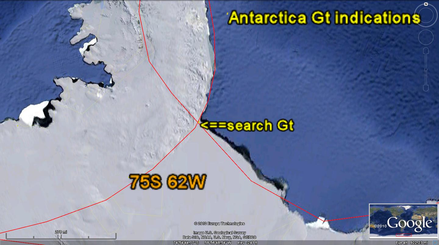
BELOW IS MY ASSESSSMENT, MADE 3 YEARS AGO; I WILL RE-READ, DETERMINING WHETHER THERE WAS A SIGNIFICANT ERROR IN MY ORIGINAL REVIEW:
Hot Springs and Coriolis Force-induced Rock Shear
An important consideration for the occurrence of hot springs is that of location on or near a river valley. Geologists would not consider this to be due to anything except that springs are a source of water flow- yielding a waterway from erosion of surroundings to create a stream and valley. However, the hot springs I have observed are beside a through-going stream, and they have not created the valley- only having enlarged and augmented it, This would include the famous springs such as Hot Springs, AR, Pagosa Springs, CO, Sol Duc in WA, and Harrison Springs in BC, Canada.
I have documented several hot springs in previous Blogs, and I will review them and others, to show that there is a strong correlation between their location and a circular river valley system (obviously for more than one river- usually two or three). This would infer that the location of a hot spring is determined by the shear of two or more Coriolis cells at their common boundary. Should a cell featuring a rising entity, such as an uplifting mountain, lie adjacent to another cell rotating in the same direction, there would be shear between their wall rocks. This usually is located in a river valley- the valley having been created by the unusual erosion occurring where boundary faulting or fracturing transpires. Two adjacent cells rotating in opposite directions would not produce shear sufficient to create HEAT (THE CELLS WOULD THEN BE IN SYNCRONIZATION- LIKE 2 GEARS IN YOUR TRANSMISSION CASE).
A Coriolis cell has some regular features:
1. There is a rotation of the cell to produce preferred river paths- either CCW for rising Crust (volcanoes, salt domes, or uplifts), and CW rotation for sinking Crust, as in basins, sinks, depressions, and salt seas;
2. There is a linear centerline, which may accompany or create the rotation- such as a normal fault with scarp- or which may precede the rotation, such as with the Mogollon Rim, AZ;
3. The cell can be seen to drag the boundary rock to indicate the direction of rotation in some cases. The outside boundary will be dragged and distorted by the oppositely-moving inner boundary to create a noticeable change in the river orientation; and,
4. The cell will be roughly circular, with a stationary inner Crustal rock and a graduation to the velocity of movement as the outer circumference is approached (fastest movement occurs at the outer boundary where slickensides may be found). A few cases exhibit elliptical shape and I am still working on this to determine whether this additional information is of value. AMAZINGLY, THE ABOVE CONCLUSIONS REMAIN USEFUL; I HAVE AUGMENTED THESE, TO ALLOW MORE UNDERSTANDING ABOUT THIS ACTIVITY WHICH IS DETERMINED BY TWO MAIN EVENTS (BOTH MECHANICAL IN NATURE, BUT WHICH CREATE HEAT SECONDARILY):
1. SHEAR RESULTS FROM BULGES MOVING WESTWARD, CREATING CONTRASTING LATERAL STRAINS;
2. ASTEROID STRIKES ACCELERATE THESE EARTH TIDE MOVEMENTS; AND,
3. CORIOLIS FORCE DETECTS ANY MOVEMENT AND CREATES A ROTATION ABOUT THE INITIAL LINEAR CONTRAST (LEFT MOVEMENT ON THE NORTH SIDE CREATES A LEFT-LATERAL FAULT).
SUMMARY:
Hot Springs are an important indicator of CONFLICTING SHEAR AND ROTATIONS IN THE EARTH’S CRUST. They occur at anomalous EARTH MECHANICS’ LOCATIONS, where there is a large contrast in stratigraphic dip, faulting, or lateral movement. Mainly they are found at intersections of drainage-ways, where two or more valleys junction. The temperature departure from normal depends upon the size of the anomalous shear circle, as shown on Google Earth.