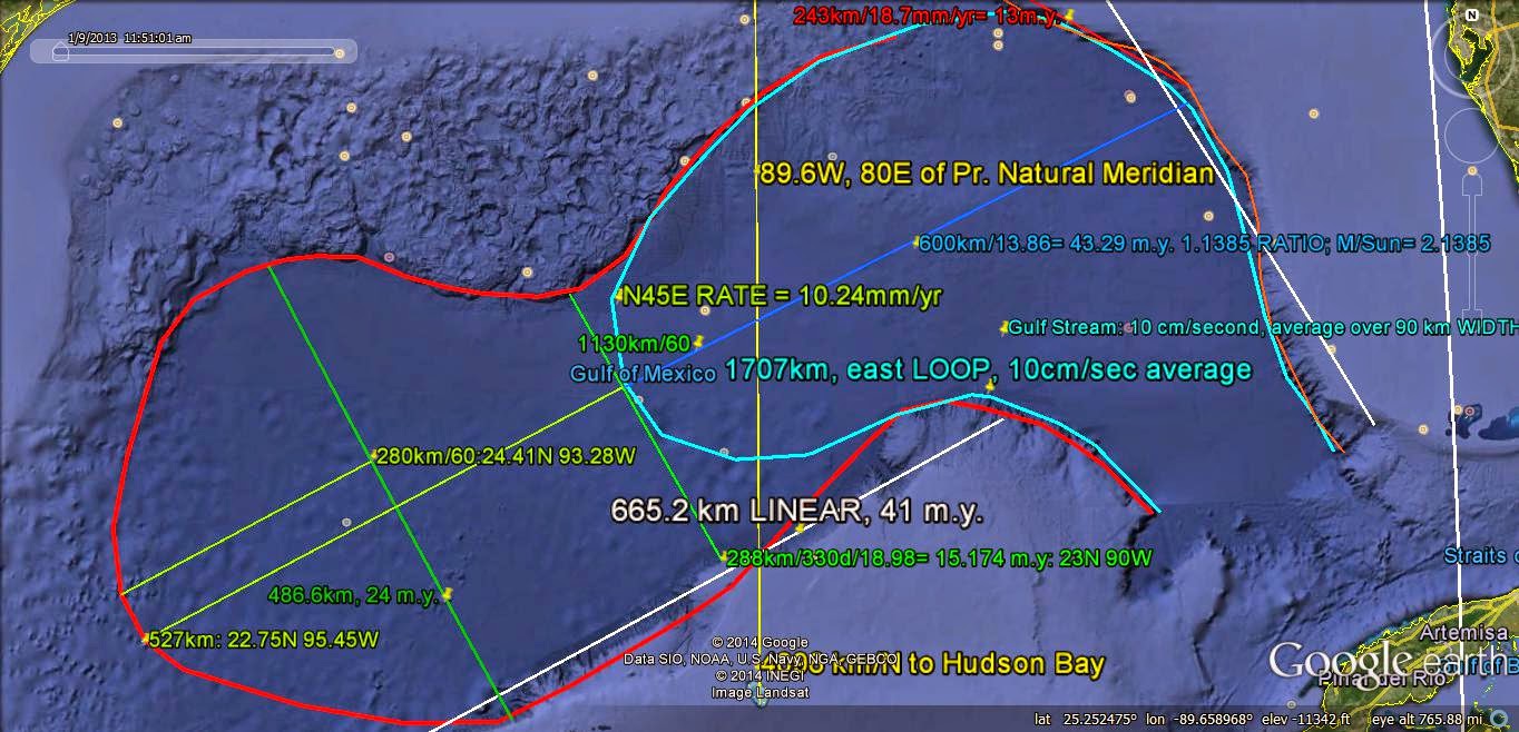
COLOR CODE is as follows: red, for COMPRESSION or Rising; blue for EXTENSION or Sinking; black for FACTUAL Information; Pink for scenarios; yellow for location or OUTCROPS; green for measurement, and white for N-S linears.
A change I have incorporated since previous publications is the FINDING that Moons create Orthogonal influences, compared to Planets and Asteroids. This is similar to STRIKE (Horizontal, by large orbits around the sun) as referred to DIP (vertical, moon orbits around Planets), in Geological TERMINOLOGY. This will require a REVISION of previous blogs, where the Moon's 5.145 degree Inclination angle was tested on Lateral Shifts. This is INCORRECT, as will be found in the following photos!
SHEAR ARCS are shown below, and they are mostly CONCENTRIC- portraying the EXPANSION, with Time, of the RISE of a dome around a Central FOCUS (the location of the initial UPLIFT). They appear to be LINEARS or straight lines, and on a small scale they are, but they appear ARCUATE, from an elevated PERSPECTIVE, and the arc SEGMENT multiplied by 360 degrees/angle subtended/(pi= 3.1416)= the DIAMETER. The diameter, divided by the Trigonometric sine of the angle CONVERSION, towards which the convex arc is pointing, yields the TIME Interval or, if ongoing, the AGE. This is shown below:
The TRIGONOMETRIC Conversion is shown with the following DIAGRAM; use this for calculating Time Intervals:

COMMON conversions are: 10.24 km/m.y. (mm/yr is EQUIVALENT) for the East CONVEX angle to which the arc points; 20.48 for the NW direction, 27.72 for West, 16.24 for South, and 30.72 mm/yr for SW pointing Convex Arcs. , e.g. left facing (
Below is a Large VIEW of the Sand Mountain, Sand Hollow BORDER, Utah (near St. George, UT) showing both the RISE and the SINK:

Notice that the RISE, which is higher in elevation (left of the half Figure 8 in the middle of the photo, that is an UPLIFT, laterally-expanding), displays linears at variable angles to a N-S line, while the SINK (right), which attracts eroding particles, has NO obvious linears, only vague arcs.
SINKS formed whenever there is PLANETARY ATTRACTION of Earth portions from the opposite side of the Sun (conjunction of Sun + Planet, both on the same side of the Earth), are created by the attraction for the far side of Earth's SURFACE towards the center of the Earth. This occurs during a portion of each Planet's ORBIT, and in between this Attraction from 2 opposing locations (upward or downward, when the Planet is behind the Sun), there is LATERAL SHEAR as the planet moves in a PATH which is adjacent or parallel to the Region or location (subject to the Gravitational FORCE)!
This is shown in a DIAGRAM below:

Applying the Solar Planetary Inclinations with a REGIONAL Perspective, the Planets influence ONLY a Portion of the Earth's Crust (the part that they either attract upward or downward, during a PLANETARY ORBIT):

This is SIMPLIFIED with a 3 cell DIAGRAM, using a half Globe or Hemisphere distribution as a background (easily remembered for field work, where the divider may be a line, RISE, or separation) with Hills, Valleys, and Protrusions such as insertions of ANOMALOUS features between different elevation Mounds, Sinks, or Scarps (shown as a divider:"TIT" from the south, or Linear separator):

SINKS are exemplified by the Arctic Ocean, which is round and is NOT influenced by the Sun, being above the Arctic Circle:

The DIVIDER, Linear Separator, or intruding "TIT" from the south, is shown for Lake Malheur, Oregon, and this separates an Evaporitic Playa (white dry lake) from its parent, the deep Lake Malheur (rounded feature to upper right).This is a Geological Field Case, for PRACTICAL use of the 3 Cell diagram or MODEL:

Evaporitic Lake, above 4097 feet elevation, is younger than the WIDER, DEEPER, Higher in Elevation (4106 ft.) Lake Malheur, and has been separated from it by the intruding "TIT" from the south (4112 ft.):

ELEVATIONS are shown above, and the expanded view, below:

Demonstrating that the MODEL may be used in the Field, for Structural Geology, follow this case of an OUTCROP of Jn, Jurassic Navaho sandstone, located in the Grapevine Wash, near I-15, east of St. George, north of Washington City, UT:

This remnant of Sandstone, shaped by EROSION, exhibits ALL of the elements of the 3 CELL Model, reinforced by Gravitational ROTATION, SHEAR, and Hardening from Compaction-compression. You may ask: "What's erosion got to do with Gravitation, other than to make rocks FALL?" Answer is that Gravity first forms the shear PATH, and erosion follows the SHEAR! Look at all sides, and you will see the SLICE (from fracturing), the 2 distinct CELLS, and the "Tit" Terrace on the north side:

ANOTHER VIEW:

North view, above shows SLICE and TILT of the Minor or PRECESSIONAL Cell, compared to the longer remnant on the right- which is the Level Axial Cell, above. Below is the view from the South. The RATIO of Axial/Precessional length may be appraised by your "eyeballs" as about 4 to 1, which is that for Mercury (365.24 days, Earth/87.97, Mercury)= 4.152. The Tilt of the smaller remnant is near 5 degrees, which is the Inclination of our Moon. These 2 bodies effect perpendicular MOVEMENTS, Vertical for the Moon,and Lateral for the Planet Mars. I assume that all planets will yield lateral indications, while Moons, which orbit around the Planets, will yield DIPS and Vertical information!
The TERRACE, which is the "TIT", advances from the Splice, and is "fixed" by the rise, due to reduced EROSION with Compaction, Compression and HARDENING from Twist and Squeezing:

Field Geologists should "MEMORIZE this 3 CELL Model, and use it for PREDICTIONS of angles, Terraces, Ratios, Dips, and Horizontal BEDDING in the field!"


Whit-Be-allovous
(to the cadence of Sullivan’s “A Modern Major General”)
A Fight Song
We trod the beaches of the land, with footprints so magnificent,
We take good care and prudence, since we’re seemingly significant;
We are geological, with thoughts so ecological-
We solve the island’s many myths, with motives almost nearly always logical.
We step o’er rock and fragile stone, with boundless love resilient,
Our thoughts, forever prime, are always bordering on the brilliant-
We zig and zag, it’s in the bag, the secrets of a stratigraphic crag,
Our yards are always full of Nature’s bounteous anticlinal swag.
Whew!
We look at cave and cliff, for clues that often are mysterious,
We form our explanations, which then sometimes are delirious;
We’re ever right, with thoughts so bright, the clays we test with subtle bite,
The Mastodons we lately seek, are almost always out of sight.
We sniff the waters of the seeps, which are mostly full of Carbonate,
We draw straight lines on maps, over which we then can fulminate-
We look not for the animal, not vegetable, but mineral,
We seek to find the local sense of Earthy Science-in-General.
We find the island’s many faults are certainly near left-lateral
The moraines make Points, but Heads (Tombolos) are quaintly mostly platter-al,
We are Geological, with thoughts so ecological-
We solve the islands many myths, with motives almost nearly always logical.
Our rare scientific group is most certainly gregarious;
With the exception of a stately few, they are hardly e’er nefarious-
They most certainly show attentiveness, to the total group’s inventiveness
They never forget a single clue, keeping constant retentiveness.
We’re constantly amused almost, by the manly interaction,
Of the way they stand their solid ground, while their stomachs are in traction-
While some will look at cuttle fish, rarely they’re rebuttal-ish,
They follow simply to a man, the leader’s every whim and wish.
They never waste a word or deed, showing ultimate economy;
They incorporate all useful fields, even invertebrate Taxonomy-
They map all Points, align all Joints,
Whenever it is possible, they listen to whomever USGS anoints.
We march out in the sand-filled fields, with ultimate sobriety;
Then we announce our final facts, with tremendous notoriety;
We use all of our abilities, with promising agilities
Before there is a final loss of all of our facilities.
We incorporate every certain fact, remaining ever all aghast;
With completely serious rectitude, we follow an iconoclast!
We are Geological, with thoughts so ecological-
We solve the islands many myths, with motives nearly always almost logical.
Harold L. Overton
Returning to the desert,
Specifically, for the SINK of Sand Hollow, UT:

Below are several VIEWS of Sand Hollow and Mountain, which will be used for a MODEL:

There is an INTERSECTION of LINEARS at the red caption; this exhibits ANGULAR SHIFTS for all 4 lineations, indicating that there is a DISCONTINUITY across the contact.
The DIVIDER, which is a SAND LINE (a portion remaining unlined for inspection, to the SW, which shifts a small amount) noticed whenever the loose sand is blown onto the paved road shown above, and this is re-plotted in a LARGER VIEW below:

ORTHOGONALLY:

The SKYLINE is a reference:

MEASUREMENT of the Sand Line ANGLE, is a reference for the next OLDER Linear, between which there is an angle CHANGE:

Angle change is slightly more than 1 degree, and it will be more carefully re-measured:

A more careful sand line ORIENTATION is measured, and it has a SHIFT of 1.26 degrees. REFER to Jupiter- which has an Inclination of 1.304 degrees from the Ecliptic Plane, below; this is a deviation of .044 degrees or 3% (the error of my measurement):
Consistency is shown for the SAND LINE south of the UPLIFT:

SOUTH EDGE of the UPLIFT:

This MODEL will be tested on other ANOMALIES in Qsna, the North American Quadrant, with a view towards determining UNIVERSAL FEATURES, such as the applicability of Planetary Inclinations to cases NOT aligned in a N-S orientation. This should be documented with smaller and larger SCALES, such as the numerous LINEARS shown in the Zion NP Uplift of 2-4 million years.

Below photo is "Zoomed in" to the Virgin River half Figure 8, or Partial ANALEMMA:

East Zion PANORAMA:

There are 2 angles which must be incorporated into an evaluation of Planetary Inclination INFLUENCE on Crustal OUTCROPS:

Several VARIABLES are shown on this DIAGRAM for Earth and Moon: Inclination and Tilt to the Ecliptic Plane; separation of Earth and Moon between centers, and between Center of Mass and Earth center (Barycenter); and tilt of Moon to its orbital Plane. Used entities are:
1. DIP Angle, which correlates with the Moon Inclination, for the Sand Mountain UPLIFT; and,
2. Lateral SHIFT, which is perpendicular (Orthogonal) to the dip, and which correlates well with angles between Fractures. Earth and Moon oscillate MONTHLY about the Barycenter, and this results in sinusoidally-traced river paths, as the water shifts each month from one bank to the other with the slight tilt change (called Meanders).

Ganymede, above is the Largest Moon in the Solar System!
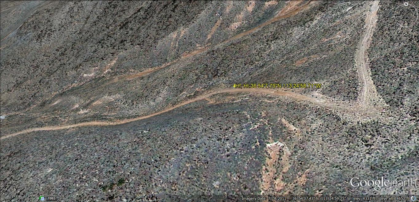
Let's use the Jovian Moons, 67 or so at present count, as a start for the dips found near the Sand Mountain feature; Honeymoon Trail SPIRAL (km diameter), and the Hurricane Fault, Hf, bedding SCARP near the east side of the Honeymoon Canyon and a 2 km distance to the east.
Initially, refer to Moons Himalia, Leda, and Lysithea, with Inclinations near 28 degrees:

Callisteo and Ganeymede have .192 to .195 degrees, too small to measure or incorporate;
Moon Europa has .47 degrees, in order of increasing MAGNITUDE;
Io has 2.21 degrees, and thereafter the Inclinations are USEFUL for significant DIP Angles;
Leda has 26.07 degrees; Himalia 27.5d; and Lysithea 29.5 degrees, which can be differentiated with Google Earth Measuring TOOL:

Now, measure the DIP Angle on the Colorado Plateau above, 2 km to the east:

I have hiked this CANYON, and there are STEEP DIPS immediately off the gravel Road leading to the Honeymoon Trail Road:

The vertical Face ANGLES at Hf have been measured by compass, but I have NOT measured the DIPS:

Above compass measurements are POSTED on the Google Earth photo; they indicate that the larger ARC is indented with smaller cycles, for the Honeymoon Trail SLOT Canyon:

Digital camera shot to North, viewing the EASIEST entrance by auto across the Honeymoon Canyon wash:

Measurements:

The TRAIL climbs up one of the few breaks in the Hurricane Fault:
Honeymoon Hike WAYPOINTS:

SLICKENSIDES show the ANGLE of rise or descent, and the near LATERAL lines:

2 km to the east, there is the DIPPING strata of near 20 degrees, shown ORTHOGONALLY:

Force = (Mass of Earth x mass of Jupiter's Moon)/separation squared x a Constant.
Using Ganeymede (the most massive) as an example, compared to Earth's Moon:
Relative ratio= Moon Mass/moon mass/(distance to our Moon/distance to Ganeymede) squared=
7.35exp22 kg/1.482exp23. 2.016 ratio, for mass; 1,070,400 km from Jupiter, or mean distance from Earth of 588 million km; Moon distance is 384,400km, and the ratio squared= 1531.25 squared= 2.344exp6. Overall ratio for the 2 Moons is 2.344/2.02= 1,160,756, or easily remembered as (M/Sun ratio of 2.16- 1)x million. M/S is still being averaged for most LIKELY RATIO!
The MILLION RATIO of our Moon to the influence of Ganeymede suggests that the Jupiter moon creates an area of INFLUENCE of 20,000km hemisphere/million, or a .02 km (20 meters or 2000 cm) wide circle. This could MODIFY by about 65 feet the formation of the Colorado Plateau, and if true, and would reinforce the influence of Venus- the usual suspect. This seems insignificant, for this Jovian moon, which has the LARGEST MASS of all Solar System satellites! A FACTOR NOT considered is the closest separation which is less than for Jupiter, about which it orbits! The orbit around Jupiter is 1.07 million km, and this subtracted from Jupiter's separation is only about a quarter percent change (insignificant).
The CASE of Ganeymede can be EVALUATED as to the Bedding Angle, where there is a .195 degree DIP up to the west. Sine of the angle= tan angle= angle in RADIANS for small angles, and this is .195 x 20 meters/57.3 degrees per radian, for the Colorado Plateau= .068 meters or 68 mm for elevation change. This would create such features as FRACTURES in outcrop Polygons, as Ganeymede moves in its ORBIT around Jupiter (with its 11.8 Earth year orbit). The quarter percent variation during the Moon orbit creates a .17 mm fracture width, and this is sufficient for Life, such as ANTS in anthills, to take temporary advantage of the openings and enlarge their cavities. Notice the FRACTURE PATTERNS, below, and the shift from RECTANGLES to Polygons with more than 4 sides in the sandstone below, upon surmounting the rise (indicating this small change of elevation and angle of attact determines the number of sides in POLYGONS). The Exterior Planet "SEES" the rise presented more directly BELOW it, and ROTATES it more than it does the slanted sides, recalling that Moons create vertical changes, while Planets effect Lateral SHFTS:

Above OUTCROP of Navaho sandstone is found north of St. George, UT, in the Snow Canyon State Park, at the western edge of the Colorado Plateau:

POLYGONS are RARE, and these can be found at Yellow Knolls, off I-15 Feeder on the North side, driving north. A Hexagon has been photographed for the Atmosphere of Saturn:

GEOLOGISTS: Augment your classifications with a MODEL that will allow Universal RU LES!
Colorado Plateau, CP, with north to left:
I just found the Canadian Maple Leaf hat!