


ABOVE is the HOLE, and below is the ANGULAR SHIFT away from Vancouver Island, British Columbia to the NW Pacific, which is a LARGER DEEPER hole:


Others are shown for various SCALES, e.g. the Chukchi RISE in the Arctic, where the deep Ocean is the "round" hole:


CLOSEUP:


ENLARGED;
A Hand Sample, which has been squeezed, displays a SLICE, with a Figure 8 showing multiple Shearing "Jerks":
"What are you DESCRIBING?" a Geologist inquired, "we have the most PRODIGIOUS TERMINOLOGY in the scientific world, and only SINKHOLES and TRANSFORM FAULTS are anywhere near what you proclaim!" Exactly, so I created a new description to avoid anything classified by the Geology Culture. SLICES may be found throughout the Crust of the Earth, and one is shown above in a common loose ROCK, to illustrate that Gravitational LATERAL (sideways) Shear influences OUTCROPS found on our daily hikes. A SLICE is a trace along a rock or outcrop, which denotes MOVEMENT of one side relative to the other- creating SHEAR along the slice, a FAULT in geological terminology.
HOLES include sinkholes, sinks, and circular features commonly seen also. They result from expansion about a slice, as in the following Photo taken in Zion NP, on the Pools Trail:
The SLICE above lies North to South through the center of this erosional feature, and there is information found from its POSITION! As TIME progresses, one side erodes faster than the other; this creates a wider portion on one side. LARGER HOLES have the slice or lateral movement near the edge, as you will see from photos later.
You should ask: "which comes first- the slice or the hole?" Considering that they derive from Earth TIDES, the shear should come first, but there has to be a CONCOMITANT EVENT, probably an ORTHOGONAL SHEAR, to create the hole simultaneously! The Moon and the Sun operate at right angles to each other, as with the Sun along LATITUDE LINES, while the Moon creates traverses along Meridians, N-S, as seen in the Pacific Ocean.
Now look at FIELD CASES, OUTCROPS:
Sand Hollow WASH above has a Hole with a SLICE, shown below:

Below photos are from the Sand Mountain HIKES:
The SLICE is exhibited as a widening TERRACE, and as a Canyon (a "hole") below the Slice cutting the UPLIFT.
Look at this Block of Jurassic Navaho, Jn, sandstone OUTCROP, which is still attached to the bedrock:
Jurassic Navaho sandstone, above, exhibits sides as being ARCUATE, and these consist of many small linears (a SET of many straight lines, altogether appearing as arcs). A circular INDENTATION contains the HOLE, which is aligned with a visible SLICE to the upper right side of the photo. This is a LATERAL movement, with some PENETRATION (creating the hole).
Notice the TERRACE ("TIT"), Hole, Tilted DOME on the left, Level Axial portion on the right, and that the terrace has only a small CONNECTION with the older remnant in this Panorama:
My assessment of these, since they appear throughout the Rigid Rocks, is that Earth TIDES continually shear and rotate the Crust on many different SCALES. This one would be on the 1/1,000,000 scale (millionth), compared to large features such as the 800 km wide Colorado Plateau (which is also rotating, shearing and creating the "hole" of Zion National Park):
Above is the Virgin River MEANDER, a SLICE of 2 million years in the making, and below is the STRAIGHT line Portion:
Viewing the MEANDER, which Exists at a Critical Location along the SLICE:
The ratio of 1.548 is low, due to the extra distance when surmounting the steep cliffs, and it is more LIKELY a ratio of 1.62 for Venus's Earth days/Venus days per orbit.
Analyzing a METEOR CRATER at Winslow, AZ, the HOLE is accepted by Geologists as made by a STRIKE, with NO evidence such as iron fragments or meteorite remains (some Shock Rock has been found, possibly from a Phreatic vapor blowout). I find that it is a Gravitational "hole" and we will search for a SLICE:
There is a N-S drainage, and below is a larger view to find the SLICE outside of the Hole:
EVALUATION, using angular deviations from the perceived FOCUS:
LARGER VIEW:
SEARCHING for sheared pavement, there are exhibited NE-SW FRACTURE PATTERNS, including those outside to the west which, are PERPENDICULAR to the Mogollon Rim orientation. This CLUE suggests that the Rim is extending to the SW, as would be expected for an EXPANDING Colorado Plateau:
I will take DIGITAL PHOTOS when I drive to Winslow, AZ again.
One which is near the Winslow, AZ Crater, and also on the Mogollon Rim, is Lake Stoneman (near hiway I-17, on the east side). This is a COLLAPSE FEATURE, researched by the Flagstaff University, and is surrounded by basalt EXTRUSIVES, which with superficial examination appears to be a Crater (like Meteor Crater, except that this exhibits a large analemma, NOT like the small central one shown on the previous analysis):
The SLICE (divider) is 1904.6 meters, which is Pluto's 17.14104 degrees Inclination x 111.111 km/degree, divided by 1000, or a thousandth of 1904.56 km, or 1904.56 meters. This slice is located by using the darkened traces on both sides, and emphasized by the DIVIDER of the Analemma. The DEEP, or sink, or HOLE, lies to the north, and I have fished and hunted geese in the shallows to the south. Northern Pike feed on Perch in the rushes, where I retrieved the Snow Geese.
MAGNIFIED:
Stoneman Lake lies just below Mogollon Rim, and is accessed via a break in the surrounding Basalt:
Stoneman Lake "HOLE" is the light grey circle, and the SLICE cuts through, but closer to the north rim! Ratio of the two parts is 1.476 (1.5, considering errors), which is the difference between Venus and Mars's Inclination Angles, from the Ecliptic Plane (3.398-1.852= 1.546). The REFERENCE Drainage is 2048 meters/10.6 degrees from a N-S line, and this refers to the Asteroid Ceres:
There are at least 4 Solar System MASSES involved: Ceres, Mars, Venus, and Pluto. Probably all Solar Bodies are effecting MOVEMENTS in this "HOLE"! Again, the Fracture indications orient NE-SW, which is perpendicular to the Mogollon Rim:
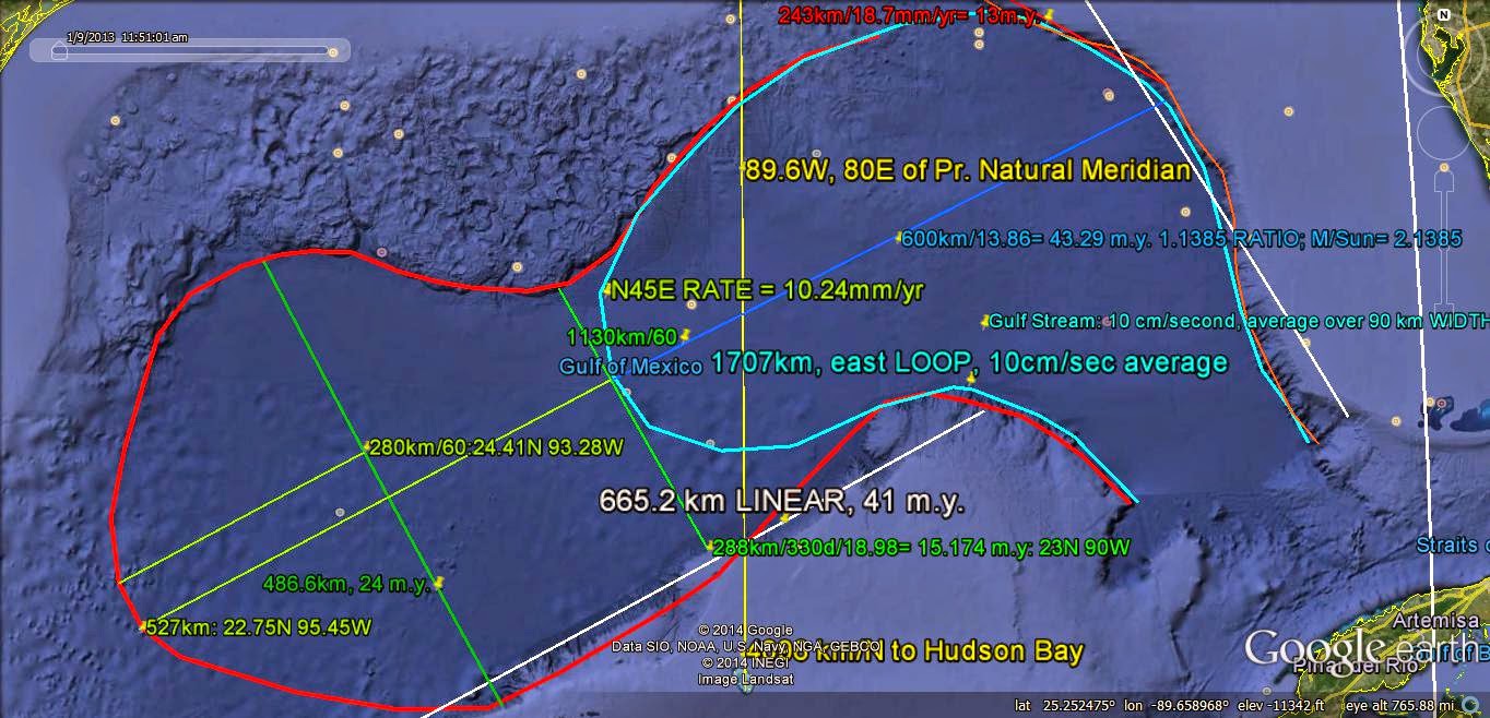
Most PERTINENT to Geology, and to Hydrocarbon DEPOSITS is the Gulf of Mexico "HOLE" straddling the slice through the Mississippi River Delta, at 90W (more accurately 89.6W):
ENLARGING:
The RED line is an outline of the ANALEMMA, which is divided by the Green LINE (a DIVIDER of the feature that allows CALCULATION of the RATIO of the 2 cells which make the Partial Figure 8):
NOT very accurate, but I will use it for the CALCULATION: {600 + 527}/527= 2.1385, is the ratio of the TOTAL DIAGONAL LENGTH to the small circle DIAMETER, which is a rough check for the influence of the Sun and Moon! Data so far indicate that 2.16= M/Sun ratio.
Notice that 600/527= 1.1385, compared to (600 + 527)/527= 2.1385, and the DIFFERENCE of 1.0 is regularly found with the Solar System MEASUREMENTS; 14.18 degrees/year for the Sun, as compared to 13.18d/day for the Moon, and Neptune's Inclination of 1.77, and .77 for Uranus; Venus's 3.398 degree Inclination and Mercury/Venus= 2.396.
Look at the Atlantic Ocean and its Mid Atlantic Ridge, MAR:
Half FIGURE 8, in this photo with North oriented to the LEFT (ORTHOGONAL) above, has the SINK (deepest) in the Northern portion of the MAR, with the RISE in the south near the Equator. It is DIFFICULT to determine the ratio of DIAMETERS, but it can be seen that the RISE (right) is larger than the North Atlantic SINK (left)! It is expected that the ratio is either 1.62, for Venus, or 1.3 for Jupiter:
The RATIO calculated from measurements is 1.18, for the aphelion/perihelion ratio, for Jupiter's ORBIT of 11.8 Earth Years (indicating that Earth and Jupiter are Gravitationally INTERCONNECTED!
What and where is the SLICE?
The slice is E-W, shown in BLUE, and is confirmed by a smaller expanding set of TRANSFORMS (in pink) which encloses the slice, and which exhibits 2 "jerks" of 3000 km each, from ANGLED TERRACES (Continental shelves) off the African Coast- all in Northern Latitudes. This hints that there will be a duplication in the South Atlantic!
South of the Equator:
Above Google Earth photo has TRANSFORMS mostly greater than 200 km N-S, and they are NOT along Latitude lines! MAR is shown in RED, and ANOMALIES occur at both ends of the BLUE LINES. 800 km is the separation commonly found in the Pacific, and this is EQUIVALENT to 7.2 degrees Latitude x 111.111 km/degree (40,000km/360=111.111).
Look at a LARGER VIEW:
It appears that I was lucky to analyze the Pacific first, since it was scribed MOSTLY by Moon and Sun Tilt and Inclination ANGLES; the Atlantic is complicated by occurrence of the Major Planets- which have introduced many ARCS of Gravitational SHEARING interactions!
A search will be made for the EQUIVALENT Moon's, Venus's, Saturn's, Mars's, Neptune's, and Jupiter's Inclination ANGLES, which are:
5.145 (moon), 3.3978 (Venus), 2.494 (Saturn), 1.8518 (Mars), 1.77 (Neptune), and 1.304 degrees (Jupiter); these multiplied by 111.111 km/degree Latitude are: 571.67 km in a N-S orientation; 377.531 (Venus); 277.138 (Saturn); 205.758 Mars); 196.673 (Neptune); and 144.889 (Jupiter):
Taking Venus first:
The first case is for Venus with its 377 km N-S between MAJOR TRANSFORMS. This is shown above, with a small error. I am selecting transforms which have two of these oriented E-W with a separation N-S for a small interval sufficient for measurement to the North (FEW in the Atlantic):
Above calculations depend upon the Moon to incur a small error! The DIFFERENCE of 8.6% appears to make this ANALYSIS Subjective, and I will select simpler cases:
Above case for Jupitear's influence of Regional ATTRACTION lies within the SLICE enclosure shown in PINK; lesser Transforms lie within the 144 km separation, and they can be for Uranus with .77 degrees Inclination (85.88 km). However, since there are 2 of them and the SMALLEST Inclination for Planets is .77 degrees, this requires that ASTEROIDS are involved (which are numerous and whose MASS is generally small, allowing only small depth penetrations in the Crust).
TRANSFORMS at the Equator are oriented E-W, which allows improved ACCURACY:
All this, in conjunction with the findings for the Pacific TRANSFORMS, indicate that the Solar System Bodies (planets, planetoids, asteroids, and comets) adjust to each other, so that their Inclination Angles change as Precession proceeds. Consequently, the angular precession creates a COMCOMITANT change in the others, i.e. the Inclinations "add up" to
offset changes.
Examples for the Sun TILT of 7.2 degrees, Mercury Inclination Angle at 7.0056, Moon at 5.145, Venus at 3.398, Saturn at 2.49424, Mars, at 1.851819, Neptune at 1.77006, Jupiter at 1.304, and Uranus at .77006 degrees yield:
Me 7.0056- Moon 5.145- Mars 1.851819= .0088, which is the smallest deviation (.17%)!
Added perspective is found with the Sun, where the Sun TILT has been investigated for PRECESSION (with an 80+ m.y. Total CYCLE). Since I have found that this ADDITIVE DEVIATION magnitude is too large, it may indicate why the following addition of Inclination angles is somewhat larger in ERROR:
Sun - Moon- Jupiter- Uranus yields .022 degrees, and should the PRESENT Segment be corrected to 7.178 (from 7.2 degrees, between Transforms in the Pacific), the result would be EQUILIBRIUM!
Similarly, if the following Sun+ Venus- Ceres (asteroid) at:
7.2+ 3.39778- 10.58= .017 (.5%), is corrected for the Sun's precession to 7.183, there would be equilibrium. Perceiving that there is presently near-equilibrium in the Solar System, the 7.2 degree Solar segment may exist at 7.178 to 7.183 degrees, or an AVERAGE of about 7.18 degrees (which is near that finally deduced in a previous Blog report).
The EQUATOR exhibits Transforms E-W, Parallel to others, with Jupiter as the most PROMINENT!
ENLARGING, at the Equator, 31W:
I will post 2 Lakes in Utah and Nevada, the Great Salt Lake and Pyramid, both of which I have ANALYZED and visited previously. These introduce new observations, since I observed them on my old computer, with Google Earth:
NOT seen by field workers is the faint CIRCULAR TRACE surrounding the Lake, terminating west of the Wasatch Range (mountains shown as 2 traces, displaced 5 degrees from each other. The Moon can be expected to exert 5.145 degrees of shift from the N-S Meridian, and this rough plot yields 5 degrees between SLICES, or linears (which could be improved with careful measurement- using amplification to find exact positions of FEATURES at termination points). Below is an enlarged VIEW:
REFERENCED to Mendocino 40.439N Latitude, and Prime Natural Meridian, 169.6W Longitude:
COMPARE with Pyramid Lake, to determine whether N-S oriented Lakes are shifted by the Moon's 5.145 degree Inclination from the Ecliptic Plane:
Pyramid Lake performs similarly to Great Salt Lake, in that the OLDEST (widest) part exhibits a Meridianal Slice on the east side, while the younger part to the south is ARCUATE. These are separated from the initiation by Linear's SHIFT of about 5 degrees (again, the Moon's Inclination Angle is 5.145 degrees from the Ecliptic Plane)! My CONCLUSION is that the Moon effects N-S LINEARS, but subsequently larger shifts greater than 16 degrees allow lesser Mass/separations squared to create ARCS. This justifies my OBSERVATION that an EQUATION of the type:
{72- (Latitude+1)}/(Latitude + 1)= must be used for DIAGONAL FEATURES, for other than Longitude. The Longitude EQUATION remains:
{180- (longitude + 1)}/[longitude + 1]= a RATIO, or dimension-less number, which can be related to Astrono-metrical Inclination degrees or ratios of 2 planets' Inclinations.
Pyramid Lake lies at CRITICAL COORDINATES; 40N 119.6W, 50E of Prime (mistake is shown on the photo)!
Another CASE, for Malheur Lake in Oregon, in the Desert of the Basin and Range Province:
The evaporitic lake is 831 k.y. and YOUNGER than deeper Malheur.This case exhibits the DIVIDER (slice) east of the "HOLE", with NO significant scarp! An analemma is visible, with the larger partial 8 to the east. The TIDAL MOVEMENT is 37.6 mm/year to the west:
Above analysis shows that the "TIT from the south is at the PERIPHERY of a CCW Rotation, with its abnormally-large RATE! Lake Malheur is a CASE where the SLICE lies east of the YOUNGER Hole, and where a "TIT" between 2 waterways is the separator of the Figure 8, with the Larger cell to the East. The ANALEMMA lies on the western edge of the Basin and Range, and shows that the BR Region is EXPANDING to the west!
Above calculations yield 1.279 m,y. (which is more likely 1.25 m.y. by the Binary Sequence), and the 831 k.y. Evaporitic Basin, in white to the West, is 448 k.y. younger. There would have been a drainage from east to west, but the Rising Tit between them has blocked it- forming the evaporites in the last 625 k.y., using the half ratio. These numbers and ratios have unknown accuracy, but are simple to remember with the Binary Sequence of 2, 4, 8, 16, etc. Accuracy may be estimated by measuring the separation of the 2 Foci (between the evaporitic and the Deep Malheur Lakes. Rates of movement vary from2 to 100 mm/year, acording to the proximity to the Periphery of the Rotation (maximum) or near the Focus (minimum Rates).
To be CONTINUED. Other cases are shown at:
Next TOPIC of Ajana Caves, India, Deccan Traps is introduced below:
20.5525N 75.700556E
DISTANT:
CALCULATIONS:
Barely discernible at 24 m.y. are the River TRACES' ARCS:
The DeccanTraps occurred at 42.84 m.y. as COMPARED to 64 m.y. for Chicxulub, and this can be checked with the OUTCROPS of Flood Basalts in India Geology. ERRORS may be appraised by using the 17.48 mm/year divisor, as it is adjusted for UPLIFT. Should there be little RISE in the E-W traverse, the accuracy is improved! 64 m.y. requires that the Diameter DIVISOR be 11.7 km/m.y. (748.8km/64 m.y.= 11.7 mm/yr., which is near the Sun TIDAL Rate)
No comments:
Post a Comment