
SUMMARY: There is NO CORRELATION of the Gravitational
ATTRACTION of the MAJOR PLANETS with the N-S Ecliptic Inclinations! The
CATASTROPHIC EVENTS such as SUBDUCTION, CASCADE VULCANISM, and movements
REVERSE to NORMAL Earth Tides are associated with the small planets and the Moon. The
LARGEST ECLIPTIC INCLINATIONS occur for the RETROGRADE movements: Pluto 17,
Mercury 7, Venus 3.39 degrees! Further, W catastrophes such as the 2008 Haiti
QUAKE and the SUBDUCTION movements are ADVERSE!
The moon has the DOMINANT INFLUENCE on SPIRALING MOVEMENTS within the Tropics of Cancer and that south of the Equator (Capricorn, but NOT at zero Latitude); this creates ROTATIONS near Baja Peninsula south end, Mexico. North of this NORTHERN LIMIT of the Earth’s 23.4375 degree tropic, there is next the Moon’s augmentation of 5.145d= 28.5825N latitude. Further north, the MAJOR PLANETS contribute to N-S gravitational LATERAL MOVEMENT, e.g. 3.39 degrees deviation for Venus + 2.49, Saturn, 1.85, Mars + 1.77, Neptune, + .77, Uranus, yields 10.27d, + 2.048 for Jupiter's moons and the asteroids= 12.318d, or 40.9N Latitude for the Mendocino Equatorial bulge. This is larger than 40.3 measured, and a 1.5% error for the asteroids.

California Mendocino Cape at 40+N latitude is the INITIATION of a traverse around the 16,000 km ELLIPSE of Qsna- the SMOOTHED PATH of ROTATION of nine 1777.77 km segments (9 x 1777.77= 16,000) stretching from an anomalous JUT into the North Pacific Ocean, just south of a VERTICAL ROTATION (subduction) under the NW, until Mt. Olympus, WA. The ellipse is rotating CCW (rising), south to the first 1777k TERMINATION, until the Baja Peninsula:

A comparison is shown for the BASE of the
 Earth’s TILT; this is near 23.2 degrees for the TROPIC of CANCER (23 26’15.142”N (23.4375 degrees) at present, for this PRECESSING EQUINOXIAL furthest north extent of the Sun’s path- 1st day of summer). At this time, the portion PROTRUDING above the ecliptic plane is subject to UPLIFT-RISE, and this continues until the northern boundary of the EQUATORIAL BULGE, at the Mendocino, CA transform! This is NOT centrifugally forced by the spin of the earth, but is GRAVITATIONALLY-LIFTED!


The first MAJOR ANOMALY is shown below (this is NOT ignoring others- such as the E-W fault system at Las Angeles, CA, but they are defined by another MECHANISM):

MAGNIFYING:

The 1777.77km distance SEGMENT is
 a 1777.77/111.11 km per degree= 16 degree of LATITUDE division, when it is measured exactly N-S. Otherwise, it is a portion of the 9 x 1777.77km= 16,000 km ELLIPSE surrounding Qsna- the North American Continent.


The MAJOR PLANETS, such as Venus, with 3.39 degree tilt from the ECLIPTIC create RECOGNIZABLE ANOMALIES- such as the one at the Mendocino Transform and the HI-Emperor Chain:
But Venus has NOT INITIATED this feature, since Pluto at 17.151d. Ecliptic deviation and Mercury at 7.01 degrees have preceded it:

Photo above shows that arcuate ROTATION still is in effect at 50N latitude!
Let's test the 2048 km N-S linear found in the Atlantic, to determine whether it is 1905.667 km- which would be for the Pluto ECLIPTIC 17.151 degree deviation (x 111.111= 1905.667):

EXPANDING the south end:

Expanding the NORTH END:

Above photo is at right angles to north, so that a MAXIMUM LENGTH can be presented. The influence of Pluto is NOT CONFIRMED! The MORE CORRECT measurement and calculated length is 2060 km (18.54d= large planets + Mercury + Jupiter moons):

GEOLOGISTS have NOT been able to INCORPORATE the ANOMALY at Baja, Mexico to the Central America SPIRAL in their TECTONIC PLATE FANTASY, so we will analyze this in terms of the ECLIPTIC DEVIATIONS NEXT:
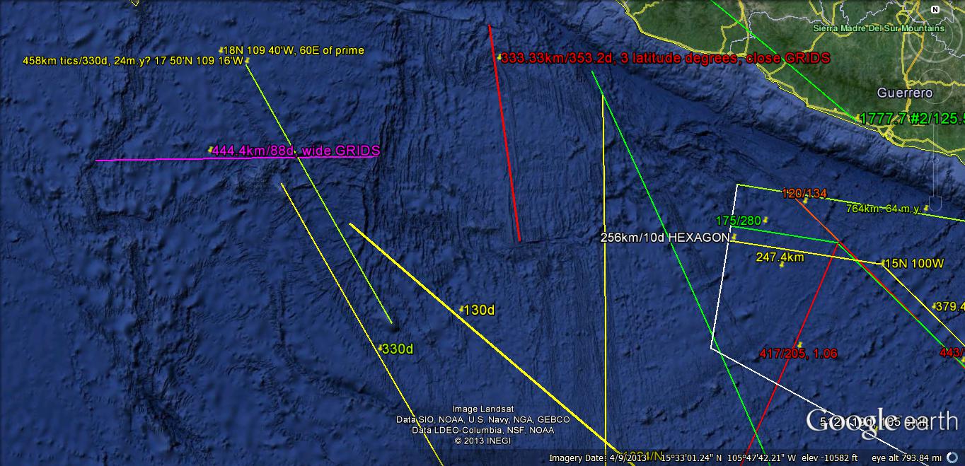
This will be SEARCHED for the 7.01 Mercury, 17.151 Pluto, and 3.39 degree Venus ECLIPTIC DEVIATIONS. The Pluto trace runs N-S, but the others may occur at 15 degree INCREMENTAL DEVIATIONS:

MOVEMENTS south of the Tropic of Cancer (23 26’15.142”N) should exhibit ONLY Moon + Sun’s ecliptic plane= 28.4375 degrees. North of this Latitude there may be other SOLAR SYSTEM masses exhibiting their gravitational shift. Pluto’s 17.151d (1905.667km) is shown, but this is complicated by the PRECESSIONAL MOVEMENT to the north with time. The TIME is calculated at 28 m.y. for 26+ minutes of ARC- averaging 1 minute/m.y. with an estimated error of 3%. Other errors arise from the REGULAR CYCLING of the EQUINOX, since it is known that PRECESSION has a Milankovitch period of 25,000 years approximately. This is subject to 3D trigonometry, and is shown in the following Google Earth photo:

MAGNIFYING, for the 1 degree ARC PRECESSION each m.y. (Pluto HARMONICS shown in white)

The FULCRUM of precession, of near 45 degrees, is shown below, to relate it to the CRITICAL LATITUDE of 24N (1/15th of the circle):

This PRECESSION is related to the Milankovitch 25,000 year CYCLE, but in this case is a HARMONIC with a period of NEAR 25 m.y. (1000:1). In addition to the regular precession of the EQUINOX, which is measureable in man's lifetime, this is a LONGER CYCLE of approximately 1 minute/million years! The SMALLER CYCLE is near 3.6 degrees/25,000 years= .144d/k.y.

Above analysis is NOT ACCURATE, but shows the GENERAL DIRECTION of movement and CW Spiraling. This is COUNTER-INTUITIVE, since the slope of Central America is to the east! South America LAGS North America, in a westerly movement, because of less EARTH TIDES along the Equator. This is a Minor COMPONENT of the LAG, and the Major movement is 30.72 mm/yr. for the SW continent (compared to NA, with 20.48 earth tides). The IMPORTANT FEATURE is the PROXIMITY of the spiral to 24N, which is a CRITICAL Latitude: 1/15th of 360 degrees, and the Longitude is near 114 40’N, or 55E of the NATURAL PRIME MERIDIAN at Diomede, AK.

These ECLIPTIC DEVIATIONS are all inter-connected, and a better COMBINATION for the 7.2d-800km transform spacing is Jupiter’s 1.31 + Saturn’s 2.49 + Venus’s 3.39d = 7.19, with small errors of 1/10th degree. This is more accurate than Mercury’s 7.01d ecliptic angle.
It seems COUNTER-INTUITIVE that these Planets with different ORBITS and MASSES would influence the EARTH CRUSTAL SHEAR-UPLIFT, but part of the mathematical connection is the relation of UPLIFT (tan angle x distance) to the angle in radians. Small angles exhibit: Tan = sine angle= angle, so that the uplift at borders is proportional to the ECLIPTIC ANGULAR DEVIATION. The distances are GRAVITATIONALLY-ADJUSTED, so that:
UPLIFT= ecliptic angle x linear mountain chain length= LATITUDE change x a constant= interval time x 50’/m.y. x 111.111km/degree- EROSION. An example is that of the COASTAL RANGE, where it rotates near 1 degree CCW, and has a length of 300 km, or 2.7 degrees of latitude change in a (180-152= 28degrees) SSW direction for an AGE of approximately 28 m.y.-Miocene. Note that the measured angle of Tropic/AGE of accompanying ARC= 23.26d/28.66= .8116 degrees per m.y. and the re-calculated age is 34.5 m.y.- closer to Oligocene:

The Atlas Mountains provide a VISIBLE CASE HISTORY, where the ROTATION of the N-S linear from the combination of at least 2 separate ECLIPTIC DEVIATIONS may be viewed. The LINEAR DIVIDER between the Western Atlas yields the orientation, and the extent provides the ORIGINAL N-S Latitude. This has been rotated from the original, and the ANGULAR ORIENTATION is now 37.77d, which is an ADDITION of 2 x 17.151, Pluto + 3.39d, Venus= 37.69 (error= 2.1%).

How is this ROTATION EFFECTED? It occurs from the OBLIQUITY of the equinoxial path. Referenced to the stars, the equinoxial reference shifts about 1 minute of ARC each million years. This is shown on Google Earth as a SHIFT (N-S) of the E-W baseline of the CYCLE. The calculated MORE PRECISE shift is about .9 minutes, or 54 seconds, each million years: Obliquity is reported on Wikipedia as NUTATION= 6.792” arc, for year 2000.

Above photo shows a ROTATION, which obscures the ORIGINAL N-S orientation; this allows a measurement of EXTENT to show the Latitude change before the rotation (but NOT the smaller, now exhibited). The ANGULAR CHANGE is the ECLIPTIC DEVIATION before rotation, and it identifies the Planet protruding above the plane:


The FULCRUM is the center of ROTATION of the Atlas Mts. about the Sahara SINK (rotating CW, oppositely to the Atlas RISE).

Cimarron Mountains., NM is a case where I have hiked and viewed the OUTCROPS at a N-S linear among the Baldy (Gold mines), Green Peak (oldest living trees- the Bristlecone Pine), and Touch-me-not- the dacite melt of Tertiary age (post Cretaceous). South of the Cimarron Creek, there is a granite RISE, where I have hunted grouse and elk; north, there is a N-S line of dikes and melt, where I experienced a BLOW-DOWN of 40 acres of timber. The area is accessed by old logging trails, and the grouse prefer the grassy trails! The melt is overlain by late Cretaceous, and the granite covered by Triassic Dockum- hence the granite RISE is older than the Oligocene? Melt (which produced a brick red sandstone to the east, the Poison canyon formation). Both of these linear outcrops are 11.11 km in length (1/10th degree latitude, or 6 minutes of ARC. This is the Obliquity-Nutation of the equinox, where the literature reports -6 units of change each year. This is timed by the 11.11km/17.48 km/m.y. = 635.58k.y. for a N-S traverse. Notice that this is 10 cycles of 40.96 k.y. AXIAL rotation + 10 cycles of 22.6 k.y. PRECESSIONAL cycles! Accordingly, not only is this effecting the NUTATION LONG TERM CYCLE, but also the Milankovitch POLAR WOBBLE-TILT relation! CALCULATED nutation is 6 minutes/.63558 m.y.= 9.44 minutes ARC per m.y.


The SEQUENCE OF ECLIPTIC movements, shown in N-S Latitude changes on the Earth’s crust:
1. The LARGE PLANETS: Venus, Mars, Jupiter, Saturn, Uranus (BUT NOT Mercury and Pluto), in addition to the Moon’s 5.151 degrees, exhibit deviations of INCLINATION, from the Sun’s ecliptic plane. This is 23.5 degrees for the EARTH’S ROTARY AXIS of rotation, and is shown by measurements created by the individual planets as they orbit about the sun; Venus 3.39, Mars 1.85, Jupiter 2.49, .77 Uranus, and Neptune at 1.77 degrees inclination to the ELIPTICAL PLANE:
2. The sum of all these LARGE PLANETS’ INCLINATIONS is 11.58 degrees, and this “fixes” the Latitude of the Mendocino transform EQUATORIAL BULGE north boundary at 23.3 Tropic of CANCER) + 5.2 (Moon) + 11.58= 40N Latitude, approximately;
3. The individual large planets add north progression according to their mass/distance squared, and this creates INFLECTIONS at the equivalent latitudes, in order of MAGNITUDE: Uranus, Neptune, Mars, Jupiter, and Venus (most NOTICEABLE, with its ratio of 1.6 to 1.625). Drastic GEOLOGIC ANOMALIES occur at each inflection, e.g. the E-W fault through Southern California;
4. The Moon is smaller and with less mass, but it is closer, and augments the NORTHERN PROGRESSION as shown at the CA coast.
There are 2 possibilities for the ECLIPTIC DEVIATIONS for the MAJOR PLANETS:
A: the largest masses with large ANGULAR DEVIATIONS obscure the smaller ones with larger deviations, so that they occur to the south. This requires a search for longer N-S linears near Mexico, with the smaller near Mendocino. This is shown for the Uranus ELIPTIC DEVIATION, near 40N latitude:

Cimarron Mountains., NM is a case where I have hiked and viewed the OUTCROPS at a N-S linear among the Baldy (Gold mines), Green Peak (oldest living trees- the Bristlecone Pine), and Touch-me-not- the dacite melt of Tertiary age (post Cretaceous). South of the Cimarron Creek, there is a granite RISE, where I have hunted grouse and elk; north, there is a N-S line of dikes and melt, where I experienced a BLOW-DOWN of 40 acres of timber. The area is accessed by old logging trails, and the grouse prefer the grassy trails! The melt is overlain by late Cretaceous, and the granite covered by Triassic Dockum- hence the granite RISE is older than the Oligocene? Melt (which produced a brick red sandstone to the east, the Poison canyon formation). Both of these linear outcrops are 11.11 km in length (1/10th degree latitude, or 6 minutes of ARC. This is the Obliquity-Nutation of the equinox, where the literature reports -6 units of change each year. This is timed by the 11.11km/17.48 km/m.y. = 635.58k.y. for a N-S traverse. Notice that this is 10 cycles of 40.96 k.y. AXIAL rotation + 10 cycles of 22.6 k.y. PRECESSIONAL cycles! Accordingly, not only is this effecting the NUTATION LONG TERM CYCLE, but also the Milankovitch POLAR WOBBLE-TILT relation! CALCULATED nutation is 6 minutes/.63558 m.y.= 9.44 minutes ARC per m.y.


At right angles, for a LARGER PERSPECTIVE, above photo is enlarged:


All of the above MEASUREMENTS show ECLIPTIC CHANGES-DEVIATIONS which are smaller than the .77 degree Jupiter influence. This reveals that HARMONICS are important in GRAVITATIONAL WOBBLE, SHEAR, and ANGULAR SHIFT due to ECLIPTIC DEVIATIONS! NUTATION-OBLIQUITY is a part of the influence of the TOTAL SOLAR SYSTEM!
I will now measure LOCAL FEATURES which I can hike and view CLOSEUP, SOUTH HALF of Whidbey Island- which has been mapped with LIDAR:

The SEAFLOOR is rising, and may be viewed at LOW TIDE:

My ERRORS are such as to make the AGE= 1/2 m.y. The LINEAR BEACH LINES indicate that ECLIPTIC DEVIATIONS-ANGULAR LATITUDE CHANGES may be calculated. Next, move inland to the Maxwelton DRAINAGE, where the various NUTATION VARIABLES may be measured on Google Earth:

Nutation= rate of WOBBLE= a constant K(360 degrees SPIN per day/cosine 23.5 equinoxial tilt), where the yearly length, tilt, SPIN, and 41 k.y. WOBBLE are inter-related.
There are 4 variables, with the Milankovitch AXIAL WOBBLE depending upon the SPIN of the Earth (360 degrees/day), the REVOLUTION of the earth’s ORBIT (which fixes the TIME per cycle), and the TILT (presently 23.5 degrees at the Equinox). THESE ALL CHANGE TOGETHER, fixed by SOLAR SYSTEM GRAVITATION! In addition, ELLIPTICITY (departure from a circular ORBIT) is a COMPOSITE of the AXIAL and PRECESSIONAL CYCLES, so that this is a hidden variable!


MATHEMATICS of DISTANCE and ARC for the Earth, with 4 digit precision:
Distance/degrees of Latitude= 40,000/360 degrees= 111.111 km/degree;
East to NE TIDAL RATE, solar= 10.24mm/yr.; NW earth tidal rate = 20.48; N rate = .707 x 10.24 + 10.24 (sine 45 degrees) = 1.707 (10.24) = 17.48mm/yr.;
N-S arcuate rate= 17.48 km/m.y./111.111 km/degree=.15732 d per m.y.; x 22.885 k.y (.022885 m.y.)= 3.6/1000 degrees= 10 x 360 degree circle/million;
.0036 degrees= .216 minutes ARC= 12.96 seconds ARC precession each m.y.
22,885 years= 22.885 k.y. is the Milankovitch precessional cycle, and one thousandth of this is the LONG RANGE NUTATION. The addition of 22.885 + 40.96 k.y.= 63.845- the 1/1.6 ratio of the 102 k.y. ELLIPTICITY CYCLE. The ICE AGE is a rare combination of Venus’s influence and the LONG RANGE m.y. 1000 x Milankovitch’s NUTATION; and,
The 40,000 km circumference earth is equivalent to the 360 degree circle, while N. Pacific TRANSFORMS are spaced 7.2 latitude degrees apart, or 800 km= 1/50th of the earth N-S.

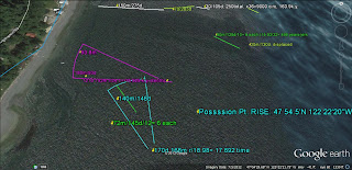
Above photo exhibits ARCS which may be water waves; this is tested by cross-counting, and the measurement in pink looks to be the TRUE AGE CALCULATION. If so, the area is subject to EARTHQUAKES in 500 year cycles! This offshore RISE is ACTIVE, and the overall evaluation is that it is an EXTENSION of the Island SOUTHWARD, similar to that of Tasmania and many other south side continental (or island) extensions:

The SCALE is 500 to 1, compared to Whidbey Island Possession RISE:

The BINARY THEOREM adds assistance to the N-S Ecliptic deviations:
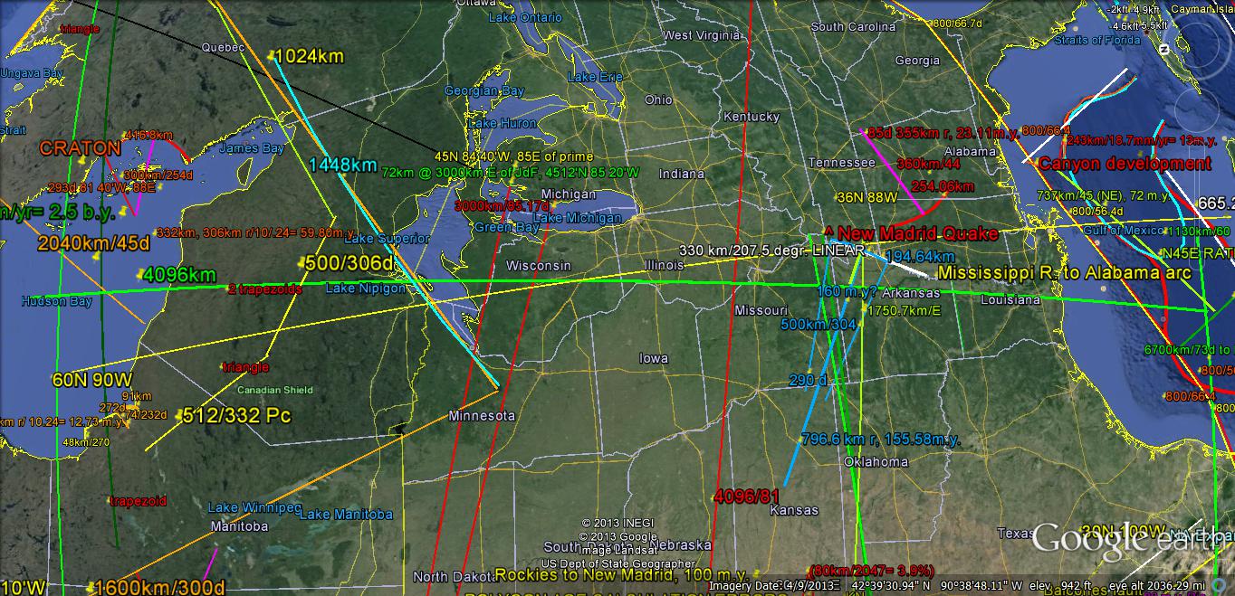
Adding all of the PLANETS’ angular ORBITS contributions, the sum = 34.751 degrees. This does NOT INCLUDE planetoids and asteroids- which have small masses. The THEOREM predicts that the other SOLAR MASSES contribute 2.048 degrees of Ecliptic ATTRACTIONS of the N-S movements along the Earth’s Meridian. This results in 36.8 Latitude, which is EQUIVALENT (x 111.111km/degree) to 4089 km in a N-S movement. There are several of these LINEARS on Google Earth, and the orientation is correct for the meridian through Chicxulub, the New Madrid earthquake zone (Mississippi River CRITICAL COORDINATES), the 2012 “Bangs” of Clintonville, WI, to the fulcrum of Hudson Bay. The 4096 km (by theorem) N-S Meridian is shown below, by a GREEN LINEAR:

Hudson Bay DETAIL:


B. Since both Mercury, 7d, and Pluto, 17d are larger in ECLIPTIC DEVIATION than any of the LARGE PLANETS, they may occur ATOP (S-N) the next smaller in size deviations (Venus with 3.39d). We'll have to solve this by TRIAL and ERROR:

These ECLIPTIC DEVIATIONS (expressed in both angles from the Sun's ecliptic PLANE, and Latitude North, on the earth'ssurface) should NOT OVERLAP, but progress from one to the next LARGER SIZE! I will proceed southward, to determine whether this is VALID:

The various MULTIPLES are shown for the MENDOCINO TRANSFORM TERMINATION. Now test for that near the CA Coast:

This does NOT arrive at a GEOLOGICAL ANOMALY, and we will backtrack and ENLARGE the Uranus case, which does:

There is considerable INFORMATION MEASURED, and this reveals the AGE, ANGULAR TURN, and E-W "Tic" timed RATE! The ratio of the tic distances is 1.25, and this "BELONGS" to Neptune/Uranus in the SERIES: n2= 1.25 (n1),as in 1.6 Venus/1.28 Mercury, and 2.5 Jupiter/2.0 Mars. ROTATION is near 45 degrees, for this small CRUSTAL SEGMENT being turned by Uranus in the TIME SHOWN by ANGULAR ANALYSIS!
ECLIPTIC DATA for the SOLAR SYSTEM
PLANETS, Planetoids, and Asteroids:
BODY ANGLE
1st Change 2nd Change REMARKS (Eccentricities,
Irregularities)
Mercury:7.0056d+ from Mendocino
778.3944 km N-S (x 111.111 km/degree)7th
Venus: 3.39d START Large pl.: 376.6666 km,
ratio= 1.6, 1.625 RETROGRADE; 6th
Mars: 1.85d, -1.54d first moon, -2.07d; 205.5555 km,
ratio= 1.88 or 2.0; 4th
Jupiter: 1.31d,- .54d, -1.0d, 60+
moons; 145.5555 km maximum BULGE, 2.5 ratio
Saturn: 2.49d, +1.18d, +1.72d; rings;
1.25x= 3.125;276.6666 km; SIZE ORDER:
5th
Uranus: .77d: -1.72d; +.54d; 85.5555
km; south of Mendocino, size 1st
Neptune: 1.77d: +1.00,; +.46d. Net=
-.35d, 4 planets; -.0875 ave., 3rd
Pluto: 17.151d: +10.145d from
Mercury; 66N latitude at Great Bear Lake, last
MOON: 23.43754d Tropic + 5.1450=
28.5825d at Baja offshore: 3175.8333 km
Notice that the 2nd derivitive yields -3.07d to Jupiter, +1.35d to Saturn, and +.35 to the last LARGE PLANET- Neptune! This is the 38.9 km length ACTIVE FAULTING in Central California!
The 90E Longitude in the Indian Ocean is well-known to sailors; it it a N-A LINEAR, which is expected to reflect the various ECLIPTIC INCLINATIONS! It is shown below, to demonstrate the CYCLES of some of the PLANETARY latitude shifts shown on EARTH. The QUESTION REMAINS: The NATURAL PRIME MERIDIAN has been used in the Western Hemisphere, Qsna, whereas now the Greenwich Meridian is REFERENCED. HOW COME? The answer involves the CHANGE of TIDAL RATES and direction of ORIENTATION for the other QUADRANTS:


The 90E Longitude in the Indian Ocean is well-known to sailors; it it a N-A LINEAR, which is expected to reflect the various ECLIPTIC INCLINATIONS! It is shown below, to demonstrate the CYCLES of some of the PLANETARY latitude shifts shown on EARTH. The QUESTION REMAINS: The NATURAL PRIME MERIDIAN has been used in the Western Hemisphere, Qsna, whereas now the Greenwich Meridian is REFERENCED. HOW COME? The answer involves the CHANGE of TIDAL RATES and direction of ORIENTATION for the other QUADRANTS:

This will be MEASURED for the known ECLIPTIC INCLINATIONS, to determine whether they are exhibited, and to find their RECURRENCE! This can be checked against the BINARY THEOREM, to test its VALIDITY:

Finally, the Mars and Mercury CYCLES are shown as a RATIO (2):

Even though Mercury is MUCH SMALLER than Mars and is Much closer to the sun, it exhibits twice the LINEAR PROGRESSION (TIME of a CYCLE of CRUSTAL SHEARING)! This determines that the VERTICAL ATTRACTION between the Planets and the SUN is NOT the determining FACTOR in shearing of earth's crust- it is the UPLIFT created by the Planet, as it moves away from the sun's ecliptic plane in an ELLIPTICAL ORBIT at an INCLINATION to the primary plane! Notice that the N-S ORIENTATION remains throughout TIME, except for Venus- which has RETROGRADE BEHAVIOR! This solves, PARTIALLY, the finding that some features on the Earth's CRUST ROTATE, while others remain N-S ORIENTED!
The CRITICAL ZONE is amplified:

Further:
Determining which Solar Body or PLANET creates the ROTATION, rather than the N-S linears requires a closer view:

Above GOOGLE PHOTO reveals that Jupiter creates the "TICS" and RETROGRADE VENUS creates the DIAGONAL LINEARS (which are nearly CONTINUOUSLY proceeding along a direction NOT NECESSARILY N-S! Consequently, ISOLATED SEAMOUNTS are indicative of MASSIVE JUPITER'S SMALL INCLINATIONS, while PARALLEL GRIDS are related to EARTH TIDES (which continue yearly)- which may be used to measure the km/m.y. RATE!
This finding is PARTICULARLY USEFUL for the OCEAN BASINS, where there is LESS EROSION from currents, and NONE from the Atmosphere! CLOSER INSPECTION is required for the LAND MASS aove Sea Level!

It is FRUITFUL to REVIEW the GRAVITATIONAL findings, shown
by CASE HISTORIES:
1.
The effect of all ECLIPTIC INCLINATIONS,
ROTATIONAL-SHEAR and POLAR WOBBLE is to create bands of UPLIFT and SINKING on
the Earth’s crust:
A.
45N latitude exhibits many ;LARGE LAKES,
starting with the Great Lakes, USA and proceeding eastward to Balkhash, Kazakhstan-
with the LARGEST VOLUME at the Caspian Sea;
B.
Large Lakes occur at FRACTIONS of the circular
360 degrees: zero Latitude for Lake Victoria and the Amazon basin; 1/30th
or 12N for Lake Nicaragua, and for 1/10th, 1/8th (45
degrees), etc.
C.
Geological ANOMALIES occur along MERIDIANS east
or west of the NATURAL PRIME MERIDIAN, by fractions of the 360 degrees Longitudinally,
e.g. 60/360= 1/6th;
D.
The MOST PROMINENT PATTERN is that of the FIGURE
8 or analemma, with ratio of the two circular portions of 1.6;

E.
Venus’s RETROGRADE orbit creates ROTATION of CRUSTAL FEATURES, so that the circular
shearing occurs, along with obvious side-by-side circles and ELLIPSES; and,
F.
There is a REPITITION in TIME and SPACE of
FEATURES, displayed in MANY SCALES- such as 1 km, 1000 km, and 10,000 km; 1
year, 100 years, 10,000 years, 1 m.y. up to 1 b.y.
2.
Patterns occur in TIME INTERVALS, such as 41,000
years for the Milankovitch AXIAL ROTATIONS, 41 m.y. (40.96?) for the PERIODIC
INSTABILITY of the Earth’s TILT, and 4.096 b.y. for the Moon’s INSTIGATION:

A.
Dynamic CATASTROPHIES occur at INTERVALS defined
by: 1, 4, 16, 64 (Chicxulub), 256 (PTr), 1,024 m.y. Great Unconformity, and
4.096 b.y.- the GRAVITATIONAL INSTIGATION of the present TIME INTERVAL. This is
a SUB-SET of the series: 1, 2, 4, 8, 16, 32, 64, 128, 256, 512, 1024, 2048, and
4096 m.y.;
B.
CONTINENTS expand LATERALLY, by 1 mm/year
(possibly 1.024), so that North America’s ORB has grown to 4096 km in 4.096
b.y., similarly to South America and the ORB of Africa west of the RIFT VALLEY;
C.
N-S SHIFT by Ecliptic INCLINATIONS is limited to
the 64N latitude (Great Slave Lake), and movements north of that limit reflect
SHIFTS by TILT INSTABILITY.

Now, by METAPHYSICS (first Principles), project the 3 Dimensional
GRAVITATIONAL BEHAVIOR, as contrasted with the 2 dimensional features found on
the Earth’s SURFACE:
I.
The Gravitational ATTRACTION of the SOLAR SYSTEM
has arranged the Planets in an ORDER: 4 ROCKY, starting with Mercury- which has
the smallest MASS and the largest Ecliptic INCLINATION (7.0055degrees),
proceeding to Mars.
II.
Next are the ASTEROIDS, which by similarity to
that found on 2D earth, exist in a ‘FORBIDDEN ZONE” such as the DIVIDER between
ARCS concave to the east next to those concave to the west. Planets which
existed there have been crushed by the GRAVITY of Jupiter;
III.
Next are the 4 Gaseous Giants of Jupiter,
Saturn, Uranus, and Neptune- all of which exhibit Ecliptic INCLINATIONS smaller
than the PLANETOID Pluto (17.151 degrees to the Sun’s Ecliptic Plane);
IV.
Forbidden ZONES occur in a CYCLICAL PATTERN
also: Kuiper belt, Oort cloud, and the disparate features within the Solar
SHIELD (to be explored presently).
QUESTIONS to be explored include:
a.
Why do the SMALLEST planets or planetoids exhibit
the LARGEST Ecliptic INCLINATIONS?
b.
How are the “WAVES” of Gravitational LATERAL
MOVEMENT related to the GEOMETRIC FRACTIONS of the Earth’s 360 degree globe?
c.
How do Orbital inclination degrees TRANSLATE to
degrees of LATITUDE on Earth?
d.
How does Jupiter create “jerks” as compared to
other Planets forming LINEAR PROGRESSIONS?


Above PHOTO exhibits
“JERKS”- (Pine Balley Monzonite, at Anderson Junction, just north of I-15 in a
rotated OUTLIER) WHICH are on a METER SCALE. These are formed by the PLANET
JUPITER, as solved by Trial and Error from the ECLIPTIC INCLINATIONS shown in
the LITERATURE.
It won’t solve anything to resort to the GEOLOGICAL LITERARTURE, since they
CANNOT FIT THESE INTO ANY CLASSSIFICATION! I have found them on the km SCALE,
as shown below. They represent HARDENING of the MONZONITE, above, and this is
performed in PARALLEL JERKING MOTIONS. This was solved by noticing that the
larger scale features are MORE RESISTANT throughout TIME.:


This CONTRASTS with SLICKENSIDES- where the
HARDENED SURFACE is CONTINUOUSLY BUFFED by the CURVILINEAR MOVEMENTS created by
VENUS. These are EASILY SORTED, and are from a COMPILATION of SLIDING, JERKING,
ROTATING-SHEARING, and ANGULAR RATE CHANGES:
e.
How do LINEARS widen with time, so that the
ORIENTATION of some remains N-S, while those associated with Venus ROTATE?
f.
What explains the CYCLIC RECURRENCE of the
multi-million year Mercury being a MULTIPLE of other Planets?
NEXT we have to understand how small bodied ASTEROIDS fit in with this ECLIPTIC INCLINATION-Latitude MOVEMENT N-S!
Ceres is the largest of the MEASURED ASTEROIDS, and has a MASS of 9.44 x 10 exponent 20; with a distance from EARTH of 2.704 x 10 exponent 8, it is MORE EFFECTIVE in gravitational UPLIFT than Pluto, because of the MUCH LESS distance squared! m/km squared= 3.491/2.704= 1.291 x 10 exponent +4. Its N-S traverse on EARTH is 111.111111 x 10.58km/degree= 1175.555km, and a SEARCH will be made for this Latitudinal CHANGE or TRAVERSE to determine whether it PENETRATES VERY DEEPLY into the CRUST! I suspect that it will be found in the ALASKAN PANHANDLE- such as the VAR IOUS CANALS? This feature should CORRELATE with SHALLOW METAMORPHISM in the NW !


VESTA:


NEXT we have to understand how small bodied ASTEROIDS fit in with this ECLIPTIC INCLINATION-Latitude MOVEMENT N-S!
Ceres is the largest of the MEASURED ASTEROIDS, and has a MASS of 9.44 x 10 exponent 20; with a distance from EARTH of 2.704 x 10 exponent 8, it is MORE EFFECTIVE in gravitational UPLIFT than Pluto, because of the MUCH LESS distance squared! m/km squared= 3.491/2.704= 1.291 x 10 exponent +4. Its N-S traverse on EARTH is 111.111111 x 10.58km/degree= 1175.555km, and a SEARCH will be made for this Latitudinal CHANGE or TRAVERSE to determine whether it PENETRATES VERY DEEPLY into the CRUST! I suspect that it will be found in the ALASKAN PANHANDLE- such as the VAR IOUS CANALS? This feature should CORRELATE with SHALLOW METAMORPHISM in the NW !

VESTA:
