
I measured with GOOGLE EARTH MEASUREMENT TOOL, further and further from the FULCRUM at Mt. Olympus (48N 123 40'W, referenced to Diomede at 169 40'W longitude, or 46E from this PRIME NATURAL MERIDIAN), TO FIND THE TIME INTERVAL where WATERWAYS WERE OPENING. The oldest was near 45 m.y., and this is the INSTIGATION of ROTATION of Vancouver Island's 45 degree turn towards Alaska. I have found that the ROTATION RATE is near 1d//TIME UNIT, regardless of the time interval, e.g. 1d/k.y. for a region, 1d/year for an OUTCROP, and 1d/m.y. for CONTINENTAL SHIFTS.


I started with the HOOD CANAL, since it exhibits a LINEAR, with abrupt turns. This is a clue that the POLYGONAL DEVELOPMENT yields the number of sides of the GEOMETRIC CONFIGURATION and the approximated CIRCUMFERENCE; e.g. a 45 degree shift, with length of 256 km on a side has an OCTAGON (360/45= 8) of 8 x 256km= 2048km, WITH DIAMETER OF 651.9 km, and time interval of 63.66 m.y, if the ARRANGEMENT faces DUE EAST (arcuate to the east), 40.96 m.y. if TIDAL MOVEMENTS are 15.915 mm/year- SSE:

The TIDAL RATES were calculated:

The MAP shows general information. Notice the 45 degree turn from the NW tip of WA State to Vancouver Island. Geologists have TRACKED the GRADUAL SLIP ALONG FAULTING, and it makes a 45 degree turn there also:

This bears FURTHER INVESTIGATION, since it EXHIBITS POLYGONAL, LATERAL, and TIDAL MOVEMENTS which normally CANNOT BE DISTINGUISHED in regional outcrops (there are many companions):

Above photo exhibits a SINK, which is larger than the Juan de Fuca CHANNEL; it is OLDER, since it has a WIDER-OLDER DIAMETER. The channel is near 1 m.y. AGE, and the ANALEMMA-FIGURE 8 shown above calculates nearly 2 m.y. (Eltanin EVENT). This division is SINKING on the east side, and RISING to the west- which is normal for COMBINATION AXIAL-PRECESSIONAL ROTATIONS (smaller shallower is to the west). This is REVERSE SIZE to usual (axial= 1.6 x precessional DIAMETER) and indicates that an ABNORMAL EVENT (ANOMALY, such as the Caspian Sea) has transpired!


The PROGRESSION so far:
1. Starting at 45 m.y. (41 m.y.,10% error), the Olympus Mountain began to rise, due to the NE-ward SHOVE of Paleocene-Eocene sediments; this occurred ATOP other sedimentary rocks, since the THRUST has no BEDROCK ROOTS;
2. At HALF of this time, Puget Sound began to open (reversal of tidal movement), as the WEST-WARD MOVING EXPANSION created CHATTER, with resulting ISOLATED ISLANDS;
3. Near 10 m.y., the SdF CHANNEL began to open (RIPPING to the EAST), due to a SPLIT in the FIGURE 8 RISE-SINK; this is a normal development, where an ANALEMMA develops a DIVIDER between the RISE-SINK. and,
4. The JdF channel WIDENS N-S, after the 2 m.y. ELTANIN EVENT!

I will document the MOVEMENTS shown on Whidbey Island, since I will be HIKING there all summer 2013:

I am particularly interested in the LEDGEWOOD SLUMP, since this occurred at the FULL MOON, April 27, shortly after MIDNIGHT- the time of MAXIMUM EXTENSION of the earth by the OPPOSING GRAVITATIONAL ATTRACTION of Sun and ,MOON. This was merely a TRIGGER, since the BLUFF was PRIMED by the CONTINUAL ROTATION of the coastline (triggered once in 20 years):


Other INFORMATION is viewed from FIELD TRIPS I made in previous years:
DOUBLE BLUFF, where I expect a NEW MOON QUAKE this year:


SIGNIFICANT EARTHQUAKES produce LIQUEFACTION, as the COMPRESSION forces sand and water upward; the ARCS Above indicate that the process is ROTATING VERTICALLY- starting with a "RIP" from the NEW MOON (and sun operating together, at this time when they both are creating a BULGE UNDERNEATH this CONJUNCTION):

Even though the EROSION is FAST, the PROTRUSION of the LAND MASS is faster, and the "JUTTING" continues to the SW:

CALCULATIONS show that this movement is due to EARTH TIDES, which are MAXIMUM in the SW direction- at least 30.72 mm/year (greater than one inch= 25.4 millimeters). When the LOCATION lies near a ROTATION FULCRUM, the RATE is greater- up to 100 mm/year (while near zero at the center of rotation):


These PRE-STONE sands were deposited by the WIND at episodes between GLACIAL RETREATS-advances; they have been subject to LIQUEFACTION BLOWOUTS whenever COMPRESSIVE SHEAR occurs at INTERFERENCES between the ELLIPTICAL, TILTING, and WOBBLE CYCLES- particularly when the 25,000 year TILT INFLECTION is at odds with the 41,000 year FLAT AND LEVEL WOBBLE This entails a REVERSAL of the TILT ANGLE CYCLE- changing the Latitude of the Tropic of Capricorn (and POLAR TILT):

A curious EXHIBIT of PRE-STONE is found near these sandstone deposits; it is a 2 x 1 dimensional LAYERED SLAB- which is soft on the outside, harder on the inside layer:


I will put more time in the below SLUMPING at Ledgewood, since this yields valuable information about CYCLICAL MILANKOVITCH SHEARING-ROTATING MOVEMENTS:

Another SLUMP OCCURRED at Fox Spit, near langley, WA, on May 27, 2013- the FULL MOON; this REINFORCES the observation that a small FRACTURE DEVELOPS when the SUN and Moon STRETCH EARTH'S CRUST. When previous EXTENSION occurs, the VERTICAL GRAVITATIOAL FORCES TRIGGER the SLUMP, NORMAL FAULT, or GRAVITY SLIDE!


FULL MOON SLUMP at Fox
Spit, 27 May/2013:
Accentuating that the OPPOSITION of sun and
moon creates FRACTURES in the EARTH’S Crust, Fox Spit exhibited a
CIRCULAR-SHAPED SLUMP at the time of MAXIMUM VERTICAL ATTRACTION of both SOLAR
MASSES to the ground surface:


This attraction AUGMENTS the
pre-existing LATERAL MOVEMENT of SCARPS and HILLS-RISES. This movement is
likely only the width of an ant, since the occurrence of ELLIPTICAL ARRAYS of
ant hills during this time of “STRETCHING" of the ground surface is noticed
monthly:

The FULL MOON opens MINUTE FRACTURES, and the ants work frantically for a week- knowing that at the NEW MOON, the opening will close again (sand grains are carried away, so that an ARTIFICIAL CAVE is produced!):

Further north is the Penn Cove LOBE of the last GLACIATION:


A SPRING FED Lake lies above Penn Cove, and is part of a TRAPEZOID:
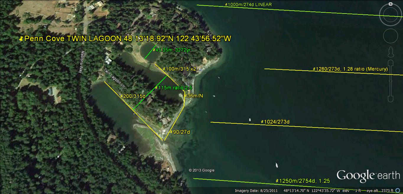
The LINEARS have REGULARITY; they exhibit either MULTIPLES of 1.6 or of 2.0 (these conflict in whole numbers):

Mounds are formed by COMPRESSION (d{jerk}/dt= CHATTER, the 2nd derivitive of GRAVITATIONAL ACCELERATION), and they may be seen as either:

Below there are CIRCULAR SHEAR JERKS each 100-1000 years apart:

The JdF, Juan de Fuca channel present them as "blips" 10k.y. apart:
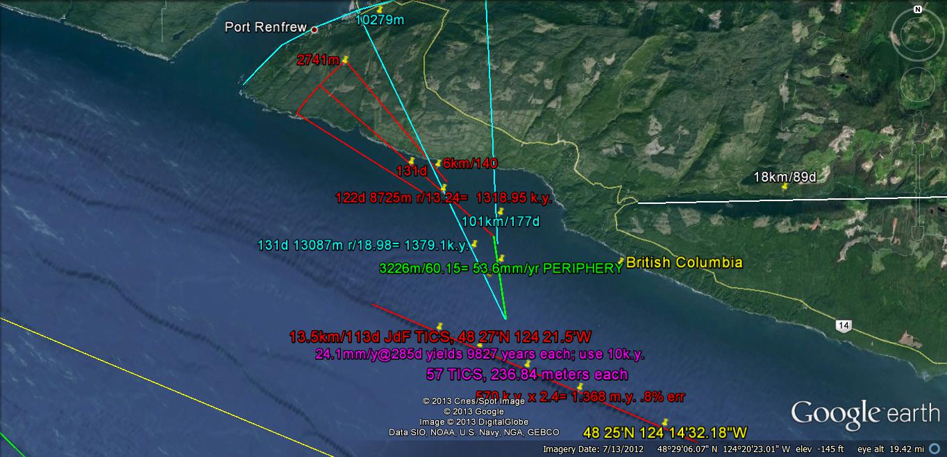
The East Coast of NA exhibits bays of equal TIME OF FORMATION, because there they are SINKS, due to the movement of the continent westward, while the CONTINENTAL ORB EXPANDS 1 mm/year in all directions. This shows a larger shift rate, since I cannot be sure where to make the N-S LINEAR DIVIDERS:


Mounds are formed by COMPRESSION (d{jerk}/dt= CHATTER, the 2nd derivitive of GRAVITATIONAL ACCELERATION), and they may be seen as either:
Below there are CIRCULAR SHEAR JERKS each 100-1000 years apart:
The JdF, Juan de Fuca channel present them as "blips" 10k.y. apart:
The East Coast of NA exhibits bays of equal TIME OF FORMATION, because there they are SINKS, due to the movement of the continent westward, while the CONTINENTAL ORB EXPANDS 1 mm/year in all directions. This shows a larger shift rate, since I cannot be sure where to make the N-S LINEAR DIVIDERS:
I made a field trip to CRESCENT Lake, where the ARCUATE FEATURES are shown at the beach. I will resurrect this from the "BOWELS" of previous submissions:

these PHOTOS will be be RE-ANALYZED later:

Above is the HALF ELLIPSE, which developed since Paleocene TIME:

A 45 DEGREE TURN is exhibited above- forming VANCOUVER ISLAND; easily seen is the CIRCULATION about the HUDSON BAY FULCRUM! Circulation to the south (Cascade VULCANISM) is about the NEW MADRID, MO division of Eastern USA CCW from Mid-Western USA CW (SINKING):


I have found areas in UT, where the 12,900 (12,800 by the BINARY THEOREM) year event left its arcuate trace, and this leads me to believe that the event occurred in ice-free areas. However, the crust would have shifted for the entire globe as the continental mass decreased. Again, this could have nothing to do with asteroid strikes, but small strikes might accentuate or trigger the changes. Notice the CIRCULAR ROTATION below, since it requres more imagination- above. Everyone can see the SPLIT which divides the ARC, and the Mima Mounds with the MULTI-DOTS above!

The ARCUATE OUTCROP TRACE is actually a series of "JERKS", as can be seen in this ROAD BED- where the casual ORV rider cannot erase them:


Mounds are formed by COMPRESSION (d{jerk}/dt= CHATTER, the 2nd derivitive of GRAVITATIONAL ACCELERATION), and they may be seen as either:
Below there are CIRCULAR SHEAR JERKS each 100-1000 years apart:
The JdF, Juan de Fuca channel present them as "blips" 10k.y. apart:
The East Coast of NA exhibits bays of equal TIME OF FORMATION, because there they are SINKS, due to the movement of the continent westward, while the CONTINENTAL ORB EXPANDS 1 mm/year in all directions. This shows a larger shift rate, since I cannot be sure where to make the N-S LINEAR DIVIDERS:


Penn Cove has kettles west of the Sound Lobe, and a HALF KETTLE is shown above! Below is DETAIL for the ones INLAND:

There is a REGULARITY to the LINEAR LENGTH, and it fits an ALGEBRAIC EQUATION:

Pondilla Lake is one of the LARGER KETTLES-SINKS; these are a REACTION to the Mima Mounds RISES to the east. Both are in A DIFFRACTION PATTERN:


