
Whidbey Island is an excellent example for determination of the influence of the rotating Earth (and its resulting Coriolis arcuate structures) on young sedimentary deposits. The island is mostly layered by glacial deposits, and is both young and covered by low viscosity (easily moved) silts and gravels. Should there be lateral movement of these young rocks (pre-stone), it can easily be seen in the vertical cliffs and Quaternary layered beds in the 150 miles of coast on the island. This writing is a resume’ of the observations and analyses made while hiking and exploring the coastline over ten years of “snow-birding”. Below is shown the model I have arranged to review the patterns and orientation of movements of the deposits found on the 50 mile-long island:

There are several large bays and many small ones on the western and southern parts of the circular parts of the Island. In addition, there are several major Heads, or Capes or Points, which jut into the two salt water Passageways- Admiralty and Saratoga, on the west and east sides of the “true” island. The bays are generally in circular shapes (near a third of a circle), while the Heads are of smaller size circular portions. Generalities are as follows:
1. Cliffs are of soft rock, while Heads are more compact and harder to scratch;
2. The circular shape of the Heads is of much smaller diameter than the associated bays on either side;
3. The bays, or sinks, are shallow and arcuate, while the heads are higher in elevation that surroundings;
4. Heads have obvious faulting nearby, while circular bays have mostly slumping and falling trees; and
5. Peat beds and multi-till layers are exhibited by the uplifted Heads, while the sinks have the Living Creatures associated with more serene waters and deposition. Bays are found on the extremities of the circular parts of the island, including Oak and Crescent Harbors at the south side of the bulges of the island around Silver Lake, and Cultus Bay, and Admiralty, Mutiny, and Useless Bays on the west side of the island.
Below is shown the couplet of Oak and Crescent Harbors (Bays), which has a tombolo on its south side and an uplift on the north side, and will be used as an example of the arrangement of bluffs and sinks which are formed in relation to each other:
.jpg)
Tombolos develop whenever there are two side-by-side lateral faults, and there is another example of this to the east about Polnell tombolo:

Bays and Points in circular patterns
Double Bluff beaches and cliffs have demonstrated that sinking bays create circular beaches, while uplifting cliffs are associated with CCW rotation of cliffs without wide sand beaches. Testing this association with another set- that of the section of coast from Bush Point to Lagoon Point- allows this to be added to the case histories. This is shown in the following digital photos, for a portion of Admiralty Bay which contains several sub-bays and minor points or jutting portions of the cliffs:


Notice that this portion of the Admiralty beach has an unusual covering of cobbles and boulders. These derive from slumping of till and bedded gravels from this sinking portion of the coast. Whenever there is a point or minor point, there occur hardened strata-even for the quaternary siltstone (pre-stone). These compacted beds are arranged in a circular pattern- around the periphery of the point, which is being uplifted. I interpret this to be an uplifted side of the sinking coast- that is, a tilted portion of Crust. Further, cliffs occur for the uplifted portion, compared to slumps for the sinking part. Evidently, rising is forced by compression, while sinking creates extension- maximizing slumping. The question remaining is “are there an equal number of sinking bays or sub-bays and points or sub-points?” By my reckoning, for every two sinks there must be an intervening uplift or rise, to prevent shearing friction warming the pore water (which would result in warm springs and exotic compounds- due to solubility change with temperature).

GOOGLE PHOTO SHOWS THE SPACE VIEW OF THE PREVIOUS CLIFFS' DIGITAL PHOTO FROM THE KEYSTONE FERRY:


Above photo from Google Earth shows that Admiralty Head is a protrusion into the Admiralty Passage- the main waterway to the Pacific Ocean (through Strait of San Juan de Fuca). The Head or Point may be seen from the Keystone Ferry, offshore Crocket Lake, as a double-uplift along the Baby Island-Ledgewood fault- which trends NW along a left-lateral trace. This fault and its associated slumping has caused a house to collapse above the Ledgewood beach (100 meters north of the County access park), separation of Baby Island from the main Whidbey Island, and creation of springs along the displacement at Greenbank at the narrowest part of the island.


There is a scarp associated with it, just north of the village of Greenbank, and “railroad tracks” of compacted-uplifted bedding boundaries in the low tide zone near Baby Island.
There are two separate uplifts associated with Admiralty Head- one created by vertical displacement along the NW fault (probably initiated during the Tertiary), and another by rebound after the ICE AGE terminated. These may be seen in digital photos taken onboard the Keystone ferry:
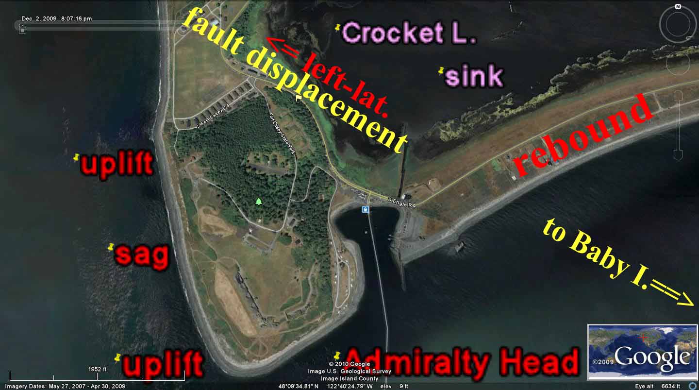

My interpretation is based on observations of the different angles of dips of the uplifts' bedding or strata and their adverse orientations, and on a traverse made on a line from the Crocket beach to the uplands to the north. The lake is a previous sink, created by weight of Pleistocene Ice, and it now is an abandoned bog- caused by rebound of the whole area (previously overlain by the kilometer thickness of GLACIAL ICE).This is shown in the analyzed photo the Crocket Lake to Admiralty Head area. Note that the fault trace occurs in a swale at the Seattle Pacific University location, while the rebound occurs noticeably at the beach- where dwellings are protected from winter storms by the mm/year rise. Salmon have “discovered" this reversal of movement, and now swim to the west near this beach (found by “trial and error” by fishermen)- opposite to that further to the south.
NOTE: OCEAN CURRENTS, ATMOSPHERIC WEATHER CELLS, AND THE EARTH'S CRUST ALL RESPOND TO CORIOLIS FORCE, BUT AT DIFFERENT RATES OF MOVEMENT (DUE TO VASTLY-CONTRASTING VISCOSITIES OF THE MEDIA BEING ROTATED).
BELOW IS THE MODEL DEVELOPED SO FAR, WHICH INCORPORATES FEATURES WHICH HAVE BEEN ACTUATED OR EXAGGERATED BY CORIOLIS ROTATIONS:

SPECIFICLY, FOR THE OAK AND CRESCENT HARBORS (BAYS) IN WHIDBEY ISLAND, WA
.jpg) BELOW IS THE DOUBLE BLUFF ROTATION (CW, IN THE ICE AGE- SINKING), AND ITS ASSOCIATED INTERMEDIATE UPLIFT SEPARATING THE SIMILARLY-ROTATING CELLS CONTAINING THE 2 SETS OF CLIFFS. SO FAR, BOTH SINKING IN THE ICE AGE AND RISING BY REBOUND (LATELY) ARE SHOWN IN GOOGLE PHOTOS AS ROTATIONS, AND A METHOD MUST BE FASHIONED TO SEPARATE THESE TWO OPPOSITELY-OPERATING FORCES (WHICH CREATE FAULTING REVERSAL OVER A 10,000 YEAR PERIOD):
BELOW IS THE DOUBLE BLUFF ROTATION (CW, IN THE ICE AGE- SINKING), AND ITS ASSOCIATED INTERMEDIATE UPLIFT SEPARATING THE SIMILARLY-ROTATING CELLS CONTAINING THE 2 SETS OF CLIFFS. SO FAR, BOTH SINKING IN THE ICE AGE AND RISING BY REBOUND (LATELY) ARE SHOWN IN GOOGLE PHOTOS AS ROTATIONS, AND A METHOD MUST BE FASHIONED TO SEPARATE THESE TWO OPPOSITELY-OPERATING FORCES (WHICH CREATE FAULTING REVERSAL OVER A 10,000 YEAR PERIOD): 
Whidbey Island geographical displays
Geography is not always pertinent to conclusions about geology or geomorphology, but the orientation of beaches on W.I. reveals that there is information from the island portrait. Below is shown a Google Earth map, for some generalities about the island. Notice the following:
1. The division of Whidbey from Camano Island is a line demarking the separation of concave beaches facing east from those facing west (you might remark that naturally all western beaches must be concave to the west, but there are eastern beaches which also are concave west- note the one near the SE town of Clinton);
2. Whidbey seems to be the result of rotations concentric with the shape of the Olympic Mountains. This is not definitive, but DOES NOT DISAGREE WITH THE PROPOSITION THAT THE MOUNTAINS ARE ROTATING AND SHEARING THE SURROUNDING CRUST, AT LEAST TO CAMANO ISLAND; and,
3. Separation of Whidbey from nearby islands and peninsulas is fairly consistent with the idea that there has occurred extension to the west because of movement of the Olympics westward. This would be consistent with TIDAL DRAG TO THE WEST OF PROTRUSIONS (RELATIVE TO LOWLANDS). Note the separation of about 3.8 km; this would be a maximal extension, because of daily erosion by water tides, turbidities, and dynamics from entities to the east of the island.

NOTICE THAT ABOVE PHOTO SHOWS CONCENTRIC BAYS, OR ISLAND COASTLINES, WITH CONCAVE WESTWARD CURVES. EAST SHORES WHICH ARE CONCAVE WESTWARD ARE NOT BEACHES, BUT SHEAR CLIFFS. THIS INDICATES THAT THOSE FACING EAST ARE ROTATING CCW (UPLIFT); THIS IS CREATING SHEER CLIFFS (WITH VERTICAL SHEAR), WHILE THOSE FACING WEST ARE ROTATING CW (SINKS). CONSEQUENTLY, THERE MUST BE AN INTERMEDIATE BUFFER CELL BETWEEN TWO CW BEACHES ON THE WEST SIDE IN ORDER TO AVOID GEOTHERMAL HEAT OF FRICTION. BELOW PHOTOS SHOWS SUCH A CASE, WHERE THE BAY BETWEEN DOUBLE BLUFF SOUTH AND D.B. NORTH HAS SHEER CLIFFS, UPLIFT- HENCE IS ROTATING CCW, WHILE FACING WEST:
 THE GOOGLE VIEW FROM SPACE SHOWS THAT THERE IS AN INTERMEDIATE ROTATION, BETWEEN THE TWO BLUFFS AT THE CLIFFS BETWEEN THE TWO SINKS AT MUTINY AND USELESS BAYS; THIS IS NOW CCW, WITH RISING, CONTRASTING TO CW, WITH SINKING DURING THE ICE AGE:

THE SHEER CLIFFS TELL AN ADDITIONAL TALE: THERE IS COMPRESSION, AS SHOWN IN THE WEDGE PHOTO BELOW, AND THIS WOULD BE THE CASE FOR UPLIFT AND CCW ROTATION(COMPRESSION, COMPARED TO EXTENSION FOR SINKS- WHICH ARE ROTATING CW):
 THERE IS A TREMENDOUS AMOUNT OF INFORMATION IN THESE CLIFFS, ONCE YOU "GET OVER" THE IDEA THAT PLATE TECTONICS IS MOVING EVERYTHING VERTICALLY. BELOW IS A PHOTO OF A SLUMP WHICH HAS OCCURRED THIS LAST WINTER, DUE TO SHEAR (WHICH IS ALONG A VEFRTICAL PLANE, BUT ROTATING LATERALLY, DUE TO ROTATION OF THE OLYMPIC MOUNTAINS CCW AS THEY REBOUND FROM PREVIOUS GLACIATION ON THE EAST SIDE (UPLIFT ALWAYS INCURS CCW ROTATION, EVIDENTALLY IN ONLY 10,000 YEARS FOR THIS QUATERNARY MELTING):
  BELOW IS THE LOCATION OF THIS DOUBLE BLUFF AND MUTINY BAY AS SEEN FROM SOUTH OF THE VILLAGE OF ADMIRALTY HEIGHTS:
WHIDBEY ISLAND IS LOCATED EAST OF THE OLYMPICS, AND IS IN THE PUGET SOUND PROPER. IT IS A TRUE ISLAND, AND THE FURTHEST EAST OF CRUSTAL MASS INFLUENCED BY OLYMPICS ROTATION (CAMANO I. IS ROTATING OPPOSITELY, AND IS GENERALLY CONCAVE EASTWARD):

 PHOTO ABOVE SHOWS A THRUST, WHICH HAS BEEN REVERSED DURING THE MELTING OF THE ICE (CW FOR SINKING, CCW FOR RISING WITH REBOUND). THIS IS SHOWN IN LARGE VIEW BELOW, TO SHOW THE SENSITIVITY OF THESE SOFT, LOW VISCOSITY SEDIMENTS- PRESTONE- TO ROTATION, SHEAR, AND LATERAL MOVEMENT OF THE CRUST:
 OTHER VIEWS ARE SHOWN BELOW, WHICH SHOW THE NORMAL BEDDING (ALMOST LEVEL) NEARBY TO THE EAST, OF TILL AND GRAVEL FROM THE MELTING OF THE ICE:

