

Additional EARTH SCIENCE findings from www.Googleearth.com
are found in other reports, and are located in www.PorOgle.blogspot.com
These include DYNAMICS of the Crust from: Coriolis rotations, EARTH TIDES (moving mass westward), the EQUATORIAL BULGE, and ASTEROID STRIKES.
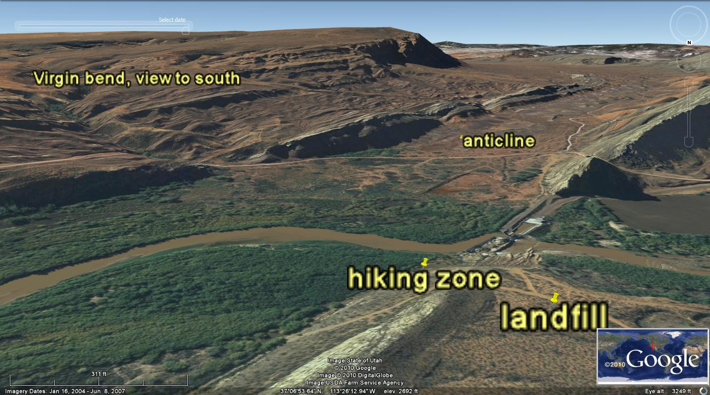
HIKE TO VIRGIN BEND, BETWEEN SAND MOUNTAIN AND LANDFILL ROAD
Access to this set of cliffs on the north bank of the Virgin River, is made via Telegraph Road, Washington City, UT. Turn south from Telegraph onto the landfill road (Note road signs), at the south boundary of Coral Cliffs housing area, proceeding 1.4 miles to a “T” in the hard-surface road. Take the right fork, and continue on the road as it deteriorates, first, to gravel at a left turn at 2.0 miles, and finally to unimproved roadway with barriers to turning off the road. An iron gate is by-passed at 2 miles, and if the gate is locked, TERMINATE! There are "NO TRESPASSING" SIGNS on the surrounding lands, so park at the first sign (NEAR 2.5 MILES) and continue south on foot. The green fields of Washington Fields lie ahead, on the opposite side of the river. The goal for this hike is to view and analyze the set of sheer cliffs with slickensides and exposure of Mesozoic rocks, which have been scoured on the outside of the river bend. This is reverse from normal, due to the rotation of a large anomalous portion of Crust from Sand Mt. to the WA fault. Proceed a quarter mile, until reaching the cliffs on the north side of the river. There are signs of H.V.MTN. MEN on the way, and it is legal to stay on the road to the Wa. dam site. Walking further to the left requires some cross-country brush-hopping, but hike as close to the north river bank as possible, without getting into soft and brushy lowlands. Look for the obvious cliffs above the river to the north.
See attached photos of the banks and Google views, to determine the dynamics of this region. There is a rotation of the river path to the north, as the anomalous cell of CRUST rotates in reaction to the WA fault. This fault is left-lateral, creating a CCW rotation of the cell about the main fault, but the faulting at the river bend rotates CW (sink), and there is a level farming area on the south side of the river. The river follows this rotation to the west, and makes a right turn from its main path on the south side of the Virgin Anticline- crossing over the SE limb. This can only occur by action of shear developed by the rotation. I anticipate that the process is produced by POLAR WOBBLE- whose trace is shown on the Google Photo. THIS IS A MAJOR FINDING, where the wobble has left its trace on Mesozoic rocks. The trace can be as old as Cretaceous, and I assume that it has formed as a result of the KT strike. However, the river path is young (post-Tertiary volcanics), and the process is continuing- developing shear as the WA fault continues to trace laterally (as well as normally).
 THE MOVEMENT IS SHOWN BY THE ABOVE CIRCULAR traces at the THRUST- SHOVING THE MESOZOIC ROCKS TO THE SOUTH, AT THIS LOCATION; slickensides below are of poor quality but indicate lateral movement:

POLAR WOBBLE, since KT, shown on Sand Mountain: HIKE DETAILS for Virgin River, UT
Below is a Google Photo which shows the region to be explored near Washington City, where the Virgin River makes a right turn- crossing the SE limb of the Virgin anticline and creating a series of meanders. This area is accessed by using roads excavated to drive to the development area, on the north bank of the Virgin. Hiking will start there; search for sheer cliffs containing slickensides will be made in the vertical wall. These will confirm lateral movement, and hopefully show “cat steps” or indentation marks as chert is dragged along the wall to “dig in” the opposing wall. This should result in right-lateral faulting (horizontally) and striations along the path to the northwest.

Note that there is a .26 km hike from the construction site, to reach the cliffs to be explored. Normally, meanders have the concave side of the arc with cliffs, since the water scours that side with increased velocity and abrading agents. In this case, the cliffs exist on the north convex side, but we will scan the south bank to determine whether there are vertical banks there also. Below is an oblique view of the area, and I will rotate Google Earth, to determine whether a south view can be scanned:

 BELOW IS THE FIRST INTERPRETATION OF THE MOVEMENTS ABOUT THE WA FAULT- CREATING THE ANTICLINAL ROTATION AND SHEAR:
BELOW I COMPARE THE POLAR WOBBLE AND SINUOUS PATH SHOWN IN SOFT TERTIARY AND RECENT SEDIMENTS IN THE SAN JUAN de FUCA STRAITS. THIS BODY OF WATER WAS FORMED SUBSEQUENT TO a 41 M.Y. ASTEROID STRIKE, CAUSING THE ROTATION OF THE REGION NORTH TO MOVE WESTWARD- WITH THE FULCRUM CENTERED ON THE OLYMPIC PENINSULA. YOU WILL NOTE THAT THE CASCADES ARE ALIGNED N-S UNTIL (SOUTH OF USA BORDER) JdF, AFTER WHICH THE REGIONAL COASTLINE ORIENTS TO THE NW. I SPECULATE THAT AN ASTEROID STRUCK IN EASTERN CANADA, CAUSING FRAGMENTATION OF ISLANDS, CIRCULAR HUDSON BAY, AND GENERAL MOVEMENT TOWARDS THE NW. THIS IS REGISTERED IN THE JdF STRAIT AS A SERIES OF SINUSOIDAL WOBBLE FOOTPRINTS, WHICH INDICATE THAT THE REGION MOVED TO THE NW- A DISTANCE OF ABOUT 18.3 KM (.45 MM/YEAR SINCE OE- Oligocene boundary with Eocene-at 41 M.Y.)


PHOTO ABOVE SHOWS THAT THE WASHINGTON FAULT IS THE CENTERLINE OF A ROTATION ABOUT THIS REGION- FROM THE VIRGIN RIVER TO SAND MOUNTAIN. I WILL CHECK FURTHER, REGIONALLY- BELOW, TO DETERMINE WHETHER THE REGIONAL VIEW SHOWS THAT IT IS LEFT-LATERAL (AS WAS SHOWN IN A HOUSE SLAB FRACTURE IN DOWNTOWN WASHINGTON CITY). WHEN YOU ANALYZE THESE LINEAR LATERAL FAULTS, SUCH AS Hf, YOU FIND THAT THE EASIEST WAY TO RELIEVE THE STRESS ALONG A LATERAL FAULT IS TO ROTATE THE CRUST SURROUNDING THE LINEAR, SUCH THAT THE ROTATION RELIEVES THE TENDENCY TO DRAG ONE SIDE OF THE FAULT COMPARED TO THE OPPOSITE SIDE:

This complicated structural feature may be viewed from several trails:
1. Climbing the Shnabkaib Hill alongside the Washington fault. This is a prominence, which protrudes as an isolated protrusion north of the backhoe-pit examined site. There is a rugged trail on the NE side of the hill, which is steep and used for local exercise. Use this trail to examine a concrete block, which has been fractures and shoved to the north by the left-lateral fault under investigation:
2. The Virgin Dam Road, from the Washington Fields area, leads to a crossing and dammed portion of the Virgin. With permission, a hike may be made to the Sand Mountain highlands and canyons on the south side of the river. Climb into the canyons from 100 meters north of the dam, and expect rough hiking;
3. A new trail has been paved and improved with benches, signs, and dog bags off the Telegraph Road in Washington City. This trail has a parking area and access (non-motorized only) across from the Washington Parkway off I-15. From I-15 go east to Telegraph until the junction. The trailhead is across (East) from the termination of the Parkway. Photos from this easy trail are shown below:

ABOVE PHOTO INDICATES THAT LATER-DEPOSITED FOSSIL WOOD FRAGMENTS HAVE BEEN ERODED AND DROPPED INTO A LOWER FORMATION- THE MOENKOPI, Trm. THIS WOULD HAVE BEEN DUE TO THE PTr EXTINCTION CONTINUING FAR INTO THE LATER TRIASSIC- SOMEWHAT REMOVED IN TIME FROM THE INITIAL PERMIAN ASTEROID STRIKE. THIS STRIKE CREATED THE APPALACHIAN MOUNTAINS AND CONTINUED its work INTO JURASSIC TIMES (AS INDICATED BY THE BARREN TRIASSIC, WITH ITS RED BEDS AND PAUCITY OF A "LIFE ENVIRONMENT". THIS COLLECTION OF WOOD FRAGMENTS WAS PHOTOED ALONG THE DRY ARROYO, WHICH IS ASPHALT-PAVED AND EASILY ACCESSIBLE TO CASUAL WALKERS. TAKE A FRIEND AND LOOK CRITICALLY AT THE ROCKS ALONG THE WAY:

 BELOW IS A PHOTO OF SLICKENSIDES FOUND IN ORTHOGONALLY-FRACTURED BLOCKS ALONG THE TRAIL (NOTE THE CALCITE FRACTURE-FILLING PLATING OR SCALE, AND LATER STRIATIONS PARALLEL TO THE BEDDING:

 ABOVE IS A DIAGRAM, ARRANGED BY ME AS AN ORIGINAL- WHICH SHOWS HOW THE FASTER-MOVING MANTLE DRAGS THE CRUST EASTWARD, CREATING SUBDUCTION. THIS IS ONLY ONE OF 4 MECHANICS' ACTIONS, WHICH DETERMINE THE STRUCTURAL ANOMALIES NOTICED IN THE EARTH'S CRUST. LINEAR MOVEMENTS (THRUSTS) CREATE A DYNAMIC WHICH CORIOLIS FORCE SENSES AND WITH WHICH ROTATIONS OF THE CRUST ARE INITIATED. ASTEROID STRIKES DISTORT THESE MOVEMENTS, AND CREATE OTHER WOBBLES AND MOVEMENTS OF THE CRUST. THESE ARE LARGE OR INSIGNIFICANT, ACCORDING TO THE SIZE OF THE IMPACT. THE LARGEST I HAVE STUDIED WAS PTr (PERMIAN-TRIASSIC BOUNDARY), THE NEXT WAS KT(CRETACEOUS-TERTIARY BOUNDARY) AND OTHERS WHICH ARE SMALLER (BUT SIGNIFICANT) OCCURRED AT 41 M.(OE), 28 M.Y.(MIOCENE) AND THE ONE WHICH INITIATED THE ICE AGE AT APPROXIMATELY 2 M.Y. I WILL INCORPORATE THESE ALL- USING FIELD MEASUREMENTS, GOOGLE EARTH, DIGITAL PHOTOGRAPHS, AND EARTH SATELLITES VIEWS OF ATMOSPHERE AND OCEAN MOVEMENTS, WHICH ARE DETERMINED BY MOON-CREATED TIDES (EARTH TIDES).
  QUADRANSPHERE (MY WORD!) IS AN ELLIPSE WITH GAPS. THE TWO MOST IMORTANT ARE THOSE IN THE EASTERN PACIFIC, SOUTH OF HIWAII AND ALSO BETWEEN THE PUERTO RICO TRENCH AND THE MAR (MID-ATLANTIC RIDGE):
BELOW IS A MODEL FOR THE CORE-MANTLE INTERFACE, WHERE THE CORE IS HYPOTHESIZED TO ROTATE FASTER THAN THE MANTLE. I DON'T USE THIS MODEL, SINCE I FIND THAT ALL STRUCTURAL CHANGES INVESTIGATED ARE THE RESULT OF CRUSTAL MOVEMENTS (VERSUS THE SLIGHTLY FASTER-MOVING MANTLE). THE GAP SHOWN IN THE ATLANTIC NE OF THE PUERTO RICO TRENCH IS SHOWN, BUT THE GAP SE OF HAWAII IS NOT SHOWN. THIS IS AN IMPORTANT DIFFERENCE, SINCE I FIND NO CRUSTAL ANOMALIES IN THAT REGION. THE QUADRANSPHERE, Qsna, IS AN ELLIPSE (AS IS SHOWN IN THE MATSUSHIMA (PINE ISLAND) MODEL, BUT IT SO FAR SEEMS TO BE MOTIVATED BY ASTEROID STRIKES AND CORIOLIS ROTATIONS OF THE CRUST:
A MODEL FOR THE EARTH-MOON SYSTEM, WHICH CREATES EARTH TIDES, FRICTION WITH THE VARIOUS PROTRUSIONS ON THE EARTH (EQUATORIAL BULGE, MOUNTAIN RANGES, AND DOMES FROM ASTEROID STRIKES) IS SHOWN BELOW. I MUST DETERMINE THE INFLUENCE THAT THE ANGLE OF THE MOON TO THE ECLIPTIC AND THE HEATING FROM THE SUN CREATES ON EARTH STRUCTURES:


Below is shown the result of analyzing the rotary shear about the Washington fault- tracing N-S alongside the Shnabkaib hill. This is strongly indicated to be a left-lateral fault, via the traces left on the rocks and in canyons encircling the linear trace. The proof is as follows:
1. A left-lateral fault will have the block opposite the viewing position moving left, regardless of where you stand;
2. Since one side of the fault is moving relatively oppositely to that on the opposing side, there will occur brittle friction, unless the earth moves a larger cell of Crust to offset this slide. Gouge from vertical displacement may obscure this lateral movement, so that a geologist who is satisfied with finding measurable VERTICAL displacement will miss the entire feature;
3. Rather than generating heat from the opposing motions, the entire Crustal block rotates in similar directions as that along the fault. The result is that the block moves leftward, or ccw, for a left- lateral fault, and vice versa. The cell of Crust rotates according to the tendency of the motivating shear along the fault plane;
4. The direction of shear may be determined by viewing small segments of rock (ON GOOGLE EARTH), which are very near the perimeter of the rotation. These are dragged along the shearing direction, showing tapering of the rock towards the perimeter; and
5. Field observations may be used to find the direction and orientation of the movement- via slickensides. Near-horizontal lineations indicate lateral faulting, and if there are chert or other hard particles in one wall of the slippage planes, the chert will “dig in” the adjoining wall, These are not as prevalent as the lineations shown on the slickensides, so that Google photos may be the principal means of determining direction of slippage (but not as accurately).
Considering that most of the large faulting occurring on the Colorado Plateau, CP, proper are right lateral faults, why is this one at odds with this trend? First, this WA fault lies in the transition zone, where many conflicting movements occur. Although the Hurricane, Hf, and Sevier faults are right-lateral, they are in concurrence with the overall rotation of CP- which is ccw and rising (UPLIFT, from an asteroid strike, on the antipode-where a crater or depression occurs).
Secondly, this is a short-range fault, comparing with the large Hf and Sevier faults. It is reported that the displacement is some 750 feet at its southern boundary, and it is noticeable as terminating near the Pine Valley Mountains, PVM. This means that its impetus is different from Hf, and not connected with the CP uplift. Analysis of edge effects from hiking around the perimeter indicates that this fault has been initiated in the Pleistocene or later (canyons at the south edge cut Pleistocene flows). My tendency is to locate an asteroid strike occurring in the Pliocene or later, or to substantiate a near-miss- which created the ICE AGE. This would be done by moving the earth further from the sun in an eccentric orbit, from which it is gradually recovering. I MUST DETERMINE THE INCIPIENCE OF THE WA FAULT- WHICH IS LIKELY A PLEISTOCENE PHENOMENON!
Earlier submissions for the www.PorOgle.blogspot.com blogsite have a finding that an asteroid struck in the south Atlantic, expelling the Shetland Islands, etc. and occurring in the Pliocene. This is in another hemisphere from the KT and EO events which struck in the northern hemisphere; hence we may expect, as with PTr off Australia, that reactions will be adverse to those in our own hemisphere. We will find other characteristics of the WA fault, and measure the AGE, INCIPIENCE, AND BEHAVIOR, compared to others on the CP proper.
 THE WOBBLE NOTICED AT THE UPPER PART OF GREENS SPRINGS ROAD REPRESENTS A REVERSAL OF THE TREND. PAST ANALYSES SHOW THAT THIS OCCURS DUE TO A WOBBLE OF THE POLES. WE WILL TRY TO FIND IF THIS IS THE LATEST, AT THE ICE AGE TERMINATION.

WE WILL HIKE TO THIS RIVER BEND FROM THE SOUTH, AT THE SAND HOLLOW DEVELOPMENT GOLF COURSE, SINCE THERE APPEARS A GRABEN IN THE WALL ABOVE THE WA DAM. THIS GRABEN DEFINITELY INDICATES EXTENSION (NOT COMPRESSION AS OCCURS WITH THE UPLIFT OF THE SAND MOUNTAIN), AND THIS MEANS THAT THERE IS A DOUBLE ROTATION AT THE GRABEN. ONE SIDE IS ROTATING CW, WHILE THE OPPOSITE IS ROTATING CCW- AS IS THE CASE FOR HARMONIOUS ROTATIONS (NO GEOTHERMAL HEAT OF BRITTLE FRICTION, BUT ALSO MEANS THAT ONE SIDE IS SINKING RELATIVELY TO THE OTHER):

 HIKES WERE MADE TO THE SAND MOUNTAIN (WHICH HAS BEEN UPLIFTED BY THE DYNAMICS OF THE ASTEROID STRIKES), TO VIEW THE ROTATIONS AND SHEARING OF CANYONS UP-CLOSE. BELOW IS THE BARE PHOTO OF THE CANYONS ANALYZED ABOVE, TO SHOW THE REGULARITY OF THESE MOVEMENTS:
 I HAVE VIEWED SEVERAL BOX CANYONS BELOW, TO DETERMINE THE LOCAL SPIRALING AND SHEARING OF WALL ROCK:
 BELOW IS THE MESOZOIC ROCK FACE IN THE BOX CANYON, ILLUSTRATING THAT THE EROSION RATE IS NOT ABLE TO KEEP UP WITH THE PROGRESSION OF THE SPIRAL CLEAVAGE ADVANCE. THE HEAD OF THE CANYON REPRESENTS THE LATEST WOBBLE- THE MOVEMENT UPWARD (CCW REBOUND FROM EARLIER ICE, IN THE NORTH OF NA, SINCE 14,000 YEARS AGO):
BELOW ARE PHOTOS OF The FEATURE, WHICH INDICATES VARIOUS ROTATIONS AND SHEAR PLANES AS THE EARTH WOBBLES FROM ITS MONTHLY EARTH-MOON CENTER-OF-MASS GYRATION, TO EXTREME FEATURES DERIVED FROM LARGE AND SMALLER ASTEROID STRIKES. TO SEE ALL OF THE GROUNDWORK NECESSARY TO DETERMINE WHICH DRAINAGES AND ROTATIONS ARE DUE TO THE VARIOUS CELESTIAL MECHANICS' MOVEMENTS, YOU WILL HAVE TO SCROLL THROUGH SEVERAL SUBMISSIONS MADE IN THE LAST TWO YEARS, ON THE BLOGSITE: www.PorOgle.blogspot.com.

 BELOW IS A DIGITAL PHOTO OF THE SPIRAL DOWNWARD INTO THE BOX (CW) AND THE UPLIFT OF THE WALLS- WHICH ARE ROTATING OUTSIDE OF THE SINK:
I am simultaneusly investigating the large faults of the Colorado Plateau, CP, WHICH YIELD CLUES AS TO THE INFLUENCE OF POLAR WOBBLE. BELOW IS A PHOTO, WHICH TENTATIVELY INDICATES THAT THE PARASHANT FAULT- ON THE EDGE OF THE TRANSITION ZONE OF CP, IS A LEFT-LATERAL FAULT (WHERE I HAVE OBSERVED OTHERS TO THE EAST ARE RIGHT-LATERAL. THIS DILEMMA REQUIRES FIELD INVESTIGATION, AND WILL PRODUCE MORE ANALYSES AND PHOTOS IN THIS AND OTHER OLDER BLOGS:


ABOVE AND BELOW ARE DIGITAL PHOTOS OF MIDDLETON MESA TO FT. PIERCE WASH- WHICH ARE ANOMALIES TO THE NW OF SAND MOUNTAIN. THE REASON THAT THIS IS SUCH A COMPLICATED AREA, IN TERMS OF SHEAR, ROTATION, AND INFLECTIONS ON GOOGLE EARTH- IS BECAUSE OF THE B&R FAULT WHICH TRACES ROUGHLY ALONG I-15 FREEWAY; THIS, IN ADDITION TO THE SMALLER ROTATIONS ABOUT THE GRASS VALLEY VULCANISM, THE SAND MT. DOUBLE ROTATION (DUE TO TRACES OF WOBBLE ON ITS WEST SIDE), AND TO THE SINKING OF THE ST. GEORGE BASIN, CREATE THE LOCATION FOR THE BEST EARTH SCIENCE INVESTIGATIONS I HAVE FOUND. EVERYTHING IS HERE! TRIPLE JUNCTIONS, LATERAL SHEAR, ROTATION OF CRUSTAL MASS, UPLIFT, DEPRESSIONS, DOMES, SPIRALING ZION UPLANDS, SCARPS, BASINS- EVEN A BIT OF OIL (LONG SINCE EXPLOITED). THE MIDDLETON MESA IS A BASALT FLOW WHICH FOLLOWED AN ARCUATE RIVER PATH OF LATERAL SHEAR (BASALT FLOWS SIMILARLY TO WATER, DOWNHILL)- IT HAS BEEN EXCAVATED BY THE HIWAY ENGINEERS, BUT NEVERTHELESSS CAN BE SEEN TO BE SLICED BY NATURE, BY THE WESTWARD MOVEMENT OF B&R. YOU WILL NEVER SEE THESE FAULTS WITHOUT USING SLICKENSIDES, SHEAR OF CONCRETE SLABS, OR BY LOOKING AT RIGHT ANGLES TO THE NORMAL FAULTING OCCURRING AT THE WA FAULT- FOR GOOGLE EARTH TRACES AND PRESENTATIONS. SHOULD YOU USE THIS METHOD, NOTICE THE SHEAR LINES SURROUNDING SAND MT. THERE ARE SEVERAL OF THEM, AND I HAD HOPED TO MAKE THIS VERY GENERAL. BUT THERE ARE INTERVENING ROTATIONS, AND IT NOW APPEARS THAT ALL OF THE GLOBAL LAND MASS (EVEN THAT UNDER THE OCEAN) IS INFLUENCED BY ROTATION AND SHEAR CAUSED BY:
1. ASTEROID STRIKES- THE MAGNITUDE OF WHICH CREATES CRATERS AND ANTIPODES OF VARYING SIZE- WHENEVER THERE IS A DIRECT STRIKE (OBLIQUE STRIKES MAY CAUSE EXTENSIONAL FAULTS, WHEREAS DIRECT HITS ARE COMPRESSIONAL);
2. EARTH TIDES, CAUSING WESTWARD MOVEMENT OF PROTRUDING CRUST (MOUNTAINS, DOMES AND UPLIFTS, e.g. THE SIERRAS, WHICH ARE MOVING WESTWARD, WHILE SIMULTANEOUSLY ROTATING CCW);
3. CORIOLIS FORCES SENSING INDEPENDANT MOVEMENTS, AS WITH THRUSTS, UPLIFTS, AND DEPRESSIONS, AND CREATING CIRCULAR PATTERNS FOR LATER WATER EROSION TO ACCENTUATE THE CIRCULAR PATHS; AND,
4. THE EQUATORIAL BULGE, EB, AND OTHER LARGE DOMES- WHICH DIVERT MOVEMENT, EVEN FOR THE WEATHER (LOOK AT MENDOCINO, CA- NOTICING EB AT 40N- AND FOLLOW ITS INFLUENCE ON CA DRY VS. OREGON WET WEATHER).

THIS IS AN IMPORTANT FINDING- THAT MANY GEOLOGICAL ANOMALIES RESULT FROM THE WOBBLE OF THE POLES, DUE TO ASTEROID STRIKES (POSSIBLY THESE CAN BE SORTED FROM WOBBLES CREATED BY OTHER EVENTS-SUCH AS THE PLEISTOCENE ICE AGE BULGE). STAY TUNED, AND CONTRIBUTE YOUR ASSESSMENT, VIA THE COMMENT SECTION BELOW.