EARTH TIDES are responsible for CREATING the various ARCUATE FEATURES seen on GOOGLE EARTH: Volcanos, River TRACES, RISING SPIRALS, CIRCULAR SINKS (giving way to LATER ELLIPSES), and FULCRUMS of ROTATION. Look for them in these INTRODUCTORY PHOTOS:
 Sullivan Knoll above, and PAH TEMPE hot spring below, in Hurricane, UT indicate GEOTHERMAL Gt emissions due to EARTH TIDAL FRICTIONAL SHEAR:
 PAH TEMPE Geothermal location (hot spring adjacent to the Virgin River):
ZION NP is a SPIRALING-UPWARDLY RISE (CCW ROTATING), and it is best seen in OBLIQUE VIEW:

The influence of the MOON and SUN’S ATTRACTION for the earth are listed in ORDER of IMPORTANCE:
2. Moon attracts the CRUST VERTICALLY monthly- augmenting the sun’s attraction during the NEW MOON, and offsetting it during the FULL MOON. This results in CONTINENTAL LATERAL SEPARATION, since the NET ATTRACTION HORIZONTALLY is WESTWARD by about 30mm/yr during full moon, and 20 mm/yr during the NEW MOON. FOR EACH VERTICAL MOVEMENT, THERE IS AN ASSOCIATED SIDEWAYS, or lateral-horizontal, SPREAD of the 3D BULGE. An ELLIPSE RESULTS, with 12 sinks and RISES occurring around the ALMOST-CIRCULAR horizontal PATTERN; over a LUNAR CYCLE, there occur 13 full moons alternately, so that 13 rises may occur in some GOOGLE EARTH PRESENTATIONS.
3. The MOON-SUN COMBINATION causes an EARTH WOBBLE; this is best visualized by referring to the CENTER OF MASS of the EARTH-MOON SYSTEM, where the earth and moon gyrate around this point in the earth’s mantle, resulting in a rotation around this FULCRUM monthly. Similarly, the earth wobbles referenced to the sun. These gyrations causes the water in creeks to SHIFT from bank to opposite bank, monthly (called MEANDERS). This MOVEMENT OCCURS WITH EACH CYCLE, but requires KILO-YEARS TO FULLY EXPRESS the 3D Bulge. This bulge is not a standing wave, but it is almost stationary- moving westward 20.48mm/year in the WESTERN HEMISPHERE (do not expect this result in another hemisphere or quadrant). CONSEQUENTLY, CONTINENTS REMAIN ALMOST STATIONARY, due to the offsetting of solar tides by the moon. NA, SA, and North AFRICA EXPAND LATERALLY by 1 mm/year, and have enlarged from a point in an ocean basin to bulges near 4096 km DIAMETER (laterally, less vertically due to EROSION and the GREATER FORCE NECESSARY for a RISE COMPARED TO A LATERAL SHIFT)- SINCE MOON'S GRAVITY EXERTED ITS INITIAL ATTRACTION, at 4.096 b.y. ORIGINATION.
4. VERTICAL MOVEMENTS have concomitant HORIZONTAL (LATERAL) SHIFTS; Observe a water wave- it rises and falls, while simultaneously rotating the water column ELLIPTICALLY (SPREADING SIDEWAYS with individual WAVE WIDTH about TWICE the HEIGHT).
5. CORIOLIS ROTATION ACCOMPANIES all MOVEMENT, whether vertical or horizontal- this is CCW RISING in the Northern Hemisphere, and CW sinking. This is accompanied by ANALEMMA DEVELOPMENT- which creates FIGURE 8 PATTERNS in CRUSTAL SHEAR, in the LOOP CURRENTS in the sea, and in ATMOSPHERIC CLOUD EXHIBITS.

nNtice the Analemmas (Figure 8s) for both the HURRICANE FAULT above, and the SOUTHERN OCEAN below. ANALEMMA ORIENTATION is generally N-S within the 40N-40S latitudes, and E-W OUTSIDE:


SIGNIFICANT CHANGES OCCUR in the ATMOSPHERE, which would happpen on a KILOYEAR BASIS on the EARTH'S SURFACE. Consequently, we can view the PROGRESSION of ARCS, CIRCLES, ELLIPSES, and WHOLE CONTINENTS during a day's viewing!
 Continuing for a DAY'S VIEWING:
LATER:

COMPARE ATMOSPHERE TIDES with earth tides which have formed the PROTRISION (TIT) south of Dugualla Bay:


Below is the GOOGLE VIEW:

And the CIRCULAR POND (artificially-formed in the last century) has been contrived by LATERAL GRAVITATIONAL ROTATION:

BACK to ZION NP- which has risen in the last 2 million years:

Further east of this geothermal feature is ZION NP, which is spiraling upwardly, rapidly, and which exhibits ELLIPTICAL CANYON WALLS, VERTICALLY:
This MINOR CANYON-INFLECTION is located at the WATCHMAN- ENTRANCE to the ZION NP. It exhibits DIP ANGLE CHANGE due to the boundry between a FLAT and LEVEL POLAR WOBBLE ROTATION and a TILTED CHANGE of ANGLE PRECESSION; the change of wobble is primarily due to long cycle EARTH TIDES, but recognized as GRAVITATIONALLY-INDUCED CHANGE of the EQUINOX.
An ELLIPSE FORMED by the LUNAR CYCLE is shown SURROUNDING the CHECKERBOARD MESA- a SHEARING-ROTATING HARDENED REMNANT from the AGE of the DINOSAURS:
 And a NIPPLE, AROUND which the ancient rocks SPIRALED, is shown below:
 This ROCK HAS FALLEN FROM ITS PERCH to the WATCHMAN TRAIL; IT EXHIBITS a CENTERLINE FAULT- INDICATING THAT IT WAS ALSO A BOUNDARY BETWEEN THE 2 WOBBLE CYCLES.

Earth tides are similar to Ocean tides, having a WAVE NATURE, but which is smaller in height. Whereas open ocean tides' WAVES are about 1/2 to 1 meter in height and 1-2 meters in width, EARTH TIDES WAVES are 1.0 centimeters high and 2.0 centimeters wide (nearly an inch) in the Northern Hemisphere- this has a vertical/horizontal ratio of 50 to one, comparing water and rock waves. The INDIVIDUAL WAVE VERTICAL/LATERAL RATIOS of two to one are fixed by the GRAVITATIONAL VERTICAL ATTRACTION/LATERAL (HORIZONTAL) SPREAD of all forces in the SOLAR SYSTEM. This is not obvious, until you notice that many everyday features are ELLIPTICAL, when viewed in 3 DIMENSIONAL SPACE: Mt. Erie beside Lake Campbell, and the island shape in the Lake below, ELLIPTICAL VERTICAL CANYON WALLS in Zion HP-Virgin River, and lakes viewed from above.
CALCULATION of INTERVAL TIME of FORMATION of a CIRCULAR FEATURE, such as a VOLCANIC CRATER:

 Campbell Lake is a HALF ELLIPSE, with an almost LINEAR NORTH BOUNDARY. The crust has moved northerly to form Mt. Erie, which is on a LOXODROME aligned with salt water N-S trending Holmes Harbor:
Holmes Harbor orients N-S to Mt. Erie:


Photo of Mima Mounds at Freeland, WA


Whereas ocean tides come and go daily, earth tides occur on a 100,000 year basis. Consequently, they may not be noticed daily, until you observe that springs stay open even when you think that they should “dry up” (they result from the yearly shear of more than 1/8th inch horizontally), that your water pipe set in your concrete slab has sheared, or that a river MEANDERS from side to side over the course of a few years (this can be related to the OSCILLATION about the BARYCENTER, ANNUALLY or to the MULTI-YEAR MOON CYCLE).
Hot springs more well-known to youth are the "boiler" (below) at the Washington City, UT location just north of the crossing of I-15 freeway by the DEVELOPING 1 m.y. (initiated) lateral fault- which is 20 km from the Hurricane Fault (20.48 km in the northern hemisphere is the time necessary to emplace a CONCENTRIC ARC about the further east Hf). THIS IS THE SITE OF THE NEXT VULCANISM in the area! Photo was taken at a "GIBBOUS" MOON, and exhibited a 70F temperature: see "upwelling" warm water, with copious Calcium-loving edible water growth (water cress):

 Closeup, you can see the now-deactivated PAH TEMPE (closed, NOT DUE TO LOW TEMPERATURE, but due to legalities). It is located on the south side of the Virgin River, about 200 meters from the Hurricane N-S fault. this is on a location which is at the intersection of two perpendicular SHEARING ROTATIONS!
Above fracture Patterns are located 4 km to the east, and they result from the vertical rotation of 23k.y.- the MILANKOVITCH PRECESSIONAL CYCLE- due to changing POLAR TILT:

PAH TEMPE is shown related to an analemma in the VIRGIN MEANDERS, RADIO TOWER CRATER, and the towns of HURRICANE-LAVERKIN:

Hot Springs, AR is probably the most well-known (a National Park), being located at the GREAT SCARP along the NE-SW DIAGONAL DIVISOR of Arkansas, with several drainages and FAMOUS QUARTZ CRYSTALS- some as large as my head (but not as thick):

Other GEOTHERMAL- HOT SPRINGS in the NA continent are shown below:
Harrison Hot Springs, CANADA:

These are from GOOGLE EARTH:


Near the GREAT BASIN NP, at the UT-NV border, there is an ARCUATE CREEK, formerly a resort for those wanting HOT WATER TREATMENT:


Warm Springs state park:

Jemez, Mtns., NM (James) is the host, and the stinking, sulphurous emissions occur south of the mountains.
Pamukkale (Cotton Castle in Turk) lies near the famous Roman ruins, with limestone CRYPTS scattered about. Working with UNESCO, we developed a log for the SUPER-HOT WELLS producing WET STEAM, BELOW:
 Veyo hot springs, UT is located near the INFAMOUS SANTA CLARA RIVER- which has produced considerable damage in recent years, with its RAMPAGING FLOODS:
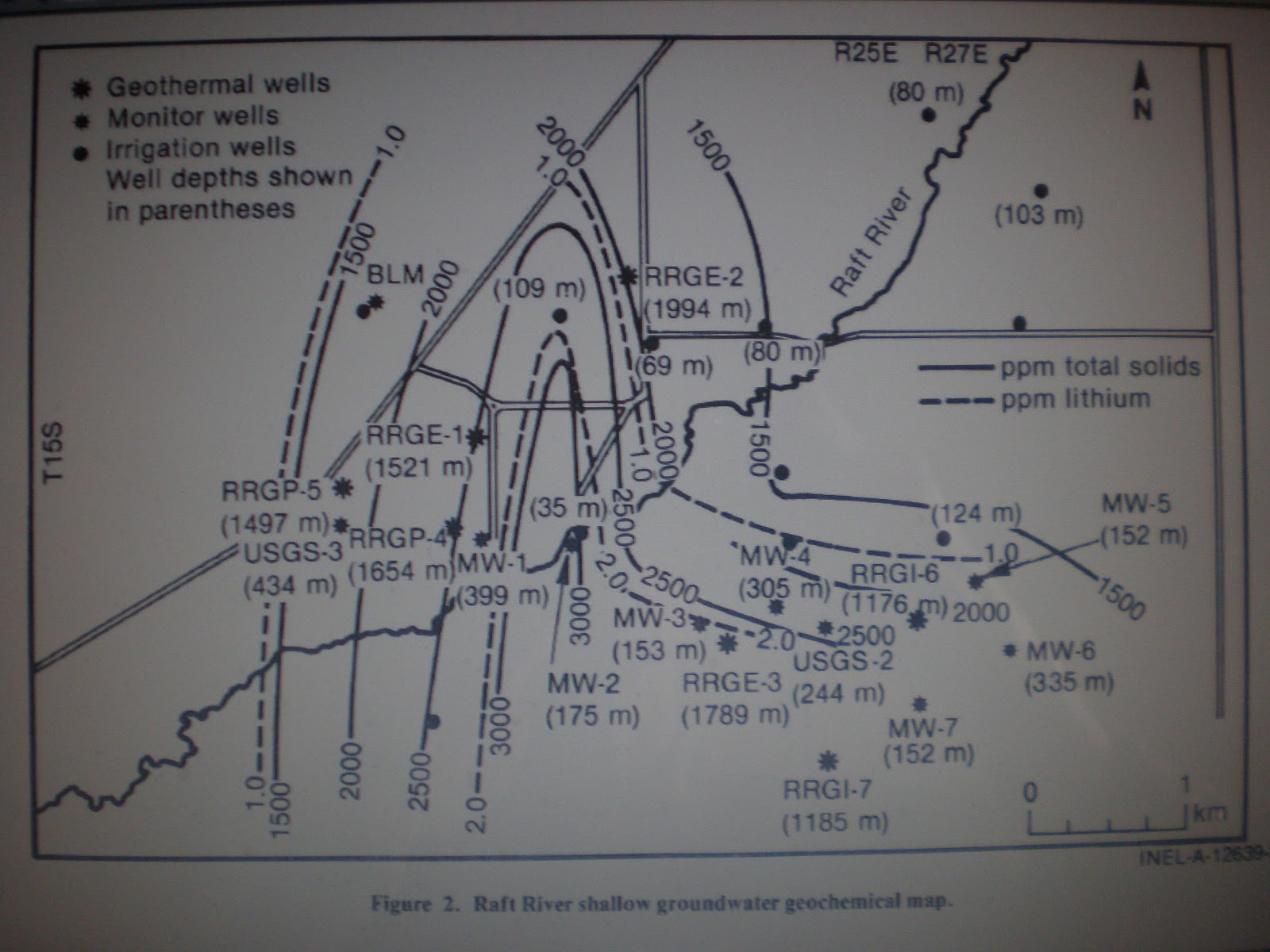
And finally (for my case histories visited in the field) the Raft River warm wells, which I logged by GEOCHEMICAL ANALYIS OF THE WATER:

I will post the exact LOCATION LATER. In the meantime, below is a GEOCHEMICAL WATER CONTENTS PLOT, where ORTHOGONAL TRENDS show how UP-WELLING is at right angles to LATERAL DRAINAGE:
Wikipedia placed WRONG COORDINATES, and I had to resort to finding a real AN0MALY FROM SHEAR-ROTATION INDICATIONS:

Or somewhat WORSE, introduced ELECTIVE,
Terminology from the GREAT DEFECTIVE-
Which becomes the NEW OBJECTIVE.
How to revert to SCIENCE TRACK,
Which leaves us taken most ABACK?
Best to take a road now black,
Improvement for some future hack.
Sometimes there occurs a warm spring, found by searching at the INTERSECTION of TWO SIGNIFICANT RIVERS or creeks:

Note the ARCUATE SHAPE of the minor creek; it has a diameter less than the Virgin arc- hence it develops HEAT with the VARYING ROTATION RATE (BRITTLE FRICTION of LATERALLY-SLIDING ROCK SURFACES):

Below is shown the 2 WATERWAYS CONJUNCTION:
 The RULE which I have found EXPERIMENTALLY is that the SCARP of an UPLIFT is 1/50th of the ROTATIONAL DIAMETER- the 400km diameter of rotation yields 8 km depth for the MUDDY FORMATION, or about 25,000 feet, at its thickest- adjacent to the Beaver Dam Mtns.
 A larger view shows the SCARP FACE- OBLIQUE:
ENLARGING:

TO BE CONTINUED!