

Whidbey Island is particularly susceptible to shear and rotation of the crust of the earth, with MILANKOVITCH-type cycles resulting from POLAR WOBBLE. A visible result of all this occurs in concrete slabs, artificial structures- such as roads, and in circular shear of cliffs and valleys.
The above digital photo was made off HIWAY 20, south of the intersection of Scenic Road and Pioneer (the main thorofare in Oak Harbor). This road has been condemned due to the continual slumping and sloughing of the asphalt at the cliffs overlooking Oak Harbor Bay. There are houses to the west, and a resident who has live there for 30 years, provided many details of the behavior of the hills west of the cliffs shown. She reports that her SE house corner has noticeably sunk- leaving cracks, and that there were seeps in the pasture behind her house. There are springs running now, in the gravels below the cliffs (too high for the daily tidal surge).
The cliffs are about 8 meters high, and are vertical, because of the yearly shear. These are shown below, with remarks about the indicated convex (outwardly) bulges and the concave (inwardly) curvatures in the cliffs. These must be interpreted in terms of what has transpired since the ICE AGE. During the ice buildup, the surface was compressed downwardly (CW sinking with the added weight), and has subsequently REBOUNDED CCW, with water transferred to the seas. This causes CHATTER, which is an opposing force to normal EARTH TIDES- that are shoving the crust WESTWARDLY. Consequently, the open ocean 20km/m.y. movement is reduced to a VARIABLE- which must be measured for the local area. This can be initially approximately with the MEASURED separation of GRID LINES, which orient N-S and E-W, and can be measured on Google Earth in both directions. The N-S lines are not disrupted by Latitude or Solar Tides, as are the E-W lines. Their spacing is smaller than the 20km/m.y. movements noticed in continental regions, such as near the Hurricane Fault, Hf:

This is ENLARGED to view the SHEAR ROTATIONS, CREATED BY POLAR WOBBLE, as exhibited by MILANKOVITCH-TYPE CYCLES:

The cliffs are vertical, with bulges extending to the east, and concavities adjacent to the bulges. These indicate sinks for the concave rotations and rises (rebound or uplift) for the bulges.
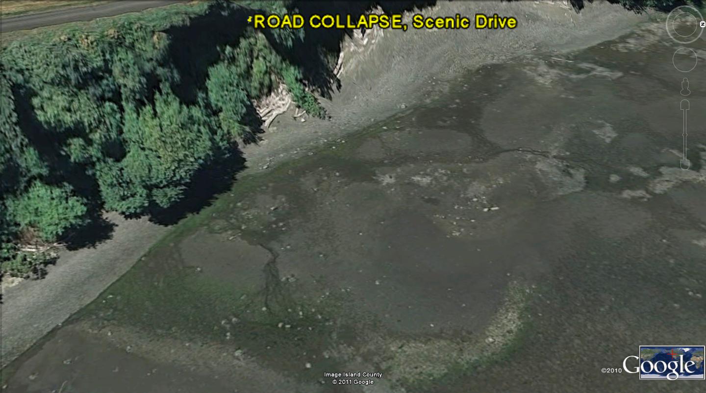
 VIEWING THE OPEN WATER IN OAK HARBOR BAY, THE ARCUATE CROSSING OF "CHATTER" LINES, OR RIDGES, MAY BE SEEN TO INDICATE SPACING (WHICH MAY BE ANALYZED FOR TIME OF INITIATION; SEE ARCUATE CROSSINGS AT PUGET SOUND, EAST OF SILVER LAKE, IN A PREVIOUS BLOG SUBMISSION) AND UPLIFT-SINKING GRID LINES ALTERNATIVELY EXHIBITED:
OTHER GOOGLE EARTH VIEWS ARE SHOWN BELOW, TO GET A VERTICAL AND AN OBLIQUE PERSPECTIVE:

THIS AREA MAY BE HIKED, AFTER PARKING AT THE CLOSEST SPACE ON SCENIC DRIVE, SOUTH OF HIWAY SR20. YOU NEED A ROPE LADDER TO DESCEND TO THE BEACH, OR YOU MAY DROP TO THE BEACH BACK TO THE NORTH- WHERE THE TIDELANDS ARE OPEN TO THE PUBLIC. BRING A GPS LOCATOR, A COMPASS, CAMERA, HIKING BOOTS FOR THE ROUGH TIDAL ZONE, AND A HIKING POLE. YOU MAY VIEW ALL THIS FROM MAYLER POINT (HOUSING AREA) NAVY RESERVATION TO THE EAST ABOUT 1 KM. MAYLER IS AN ATROPHIED TOMBOLO, WHICH HAS PROGRESSED TO BECOME A PENINSULA RISING WITH REBOUND, WITH ITS OWN THRUSTS, UPLIFTS, AND CURVILINEARS

SUMMARY of Scenic Drive, Oak Harbor ROAD COLLAPSE:
Scenic Drive had a metal post-barricaded border which has collapsed, along with the eastern portion of the road. This could be dated, and it has sheared away from the road in the 50 years since installation. This represents about 10 cm/year migration of the cliffs to the west, and this can be measured by the thickness of the blocks which have sheared away from the cliffs below the road. These cliffs shear intermittently- not necessarily every year.

The cliffs are vertical, except for bulges and cavities; the bulges represent rotations vertically, as do the cavities- both shearing in opposite directions (bulges easterly, or CCW, with shear developing between those planes (vertical slices) rotating oppositely.
Land or Earth Tides, similar to water tides, move the cliffs westerly- up to 20mm/year; the 200mm/year observed for Scenic Drive is excessive, and probably indicates a ten year cycle (at least) for “jerks” or CHATTER of opposing movement against the normal 20mm/year.
Horizontal arcuate features can be seen on the Bay bottom, with digital photos and Google Earth scans. These are similar to Mima Mounds, with arcuate features crossing each other in a diffraction-type pattern. They can be analyzed with photos from a digital camera or Google Earth. They result from transfer of mass of ice from the ICE AGE to the sea laterally- yielding CHATTER, or reduced earth tidal movement yearly. The chatter has been calculated to occur on a 1000 or more YEARLY cycle, after the ice has been moved- to create a rare and mass-shift POLAR WOBBLE. The resulting shift to the west is on the order of 1mm/year or more (less than 20mm/yr.).

Processes observed locally can be used as a general tool for predicting shear and sloughing of roadways and cliffs. It occurs where there are observable arcuate traces in the bays and waterways near cliffs. This can be predicted for the eastern shorelines of islands, as well as for any cliffs convex to the west, or concave to the east.
BELOW IS AN ANALYSIS OF ROAD COLLAPSE IN A REGION FAR FROM WHIDBEY ISLAND. THE SAME FEATURES ARE DISPLAYED ALONG THE VIRGIN RIVER, UT, AS WITH THE OAK HARBOR SHEAR: A SINKING CW ROTATION ALONGSIDE A RISING LAND PORTION, SHEAR MARKS IN THE TRAIL PARALLEL TO THE GENERAL ROTATION OF THE AREA (SHOWN BY THE WATER'S EDGE), AND A DEMARCATION OF THE HALF-WAY POINT IN THE DISRUPTION OF THE CYCLE. THIS CALCULATES A 50K.Y CYCLE, AND MY ERRORS ARE SUCH AS TO ADVISE THAT IT IS A MILANKOVITCH 40K.Y. CYLE OF AXIAL WOBBLING OF THE POLES (PHOTO TO FOLLOW)

ENLARGING:

THE TRAIL WAS BLOCKED, DUE TO SHEAR CIRCLE ENLARGEMENT DURING 2011 (ASPHALT NOW MISSING- VOLCANIC GASES "HISSING"):

