
“Sinkholes are ROUND” when viewed from sufficient distance, and this is a clue to their origin. Coriolis rotations dictate that a sinking entity rotates clockwise, as is well-known from viewing Hurricanes from space, with remote photography. The main destructive portion of a hurricane rotates CCW, as the rising moisture-laden air mass sheds its water via violent rains. Rising terminates at the top of the system, since there is no light saturated air to ascend further (water has a molecular weight of 18, lighter than the normal dry air with 29, hence saturated air is lighter than dry air). The dry air has to exit, and with its increasing density, it descends- creating an “EYE” in the otherwise cloudy system. This eye is dry, it rotates CW, sinks, and reveals calm clear cloudless skies inside it. Hurricane systems are created by low pressure waves of air over warm tropical seas. They are called typhoons in the Pacific, and cyclones elsewhere. Their destructive power is related to the size and decrease of atmospheric pressure in the edge of the system. Cyclone CATARINA OF 2004 IS SHOWN BELOW, FOR THE SPACE VIEW OF THE ROTATION AND EYE FORMED BY DOWNWARD SPIRALING OF THE DRY AIR:

Similarly, the CRUST of the Earth rotates with many orientations, under the impetus of its wobbles- which are created by the orbital cycles, such as PRECESSIONAL, AXIAL, and ELLIPTICAL gyrations (relative to the normally-spinning and revolving globe). The question now investigated is the cycle and time of evolution of sinkholes seen on the surface of the earth. Below is the one I have already solved and photoed:

 THIS FEATURE IS SHOWN IN OBLIQUE PERSPECTIVE, SO THAT THE VARIOUS MILANKOVITCH CYCLES, JUTTING OF THE RIGHT-LATERAL FAULT INTO THE SAND HOLLOW RESERVOIR, AND THE LINEAR WHICH SEPARATES THE NORTH-MOVING THRUST TO THE WEST FROM THE SOUTH-MOVING ROTATION TO THE EAST MAY BE SEEN:


 Below is a digital photo of a Specimen of unique SLICKENSIDES made FROM shearing and scraping BY the adjacent brittle rock. This rock was part of a basalt extrusion, which has been sheared after cooling:
  ABOVE IS A DIGITAL PHOTO OF THE DRAINAGE OF SULLIVAN KNOLL TO THE NORTH. THIS BREACH HAS BEEN CREATED BY AN ORBITAL ROTATION (NOTE THE CONCAVITY TO THE LEFT- EAST, OF THE 40K AXIAL SHEARING). DRAINAGES, AS FAR AS I CAN ANALYZE, ARE MOSTLY DUE TO MILANKOVITCH CYCLES OF THE 40 AND 100 K YR. VARIETY. RARELY DO I FIND THE PRECESSIONAL 23-25 K YR. CYCLE.
 THIS SHEARING ROTATION HAS LEFT ITS IMPRINTS ON THE SURFACE OF BASALT OUTCROPS. NOTE THE FAINT CIRCULAR AND STRAIGHT CURVILINEARS:
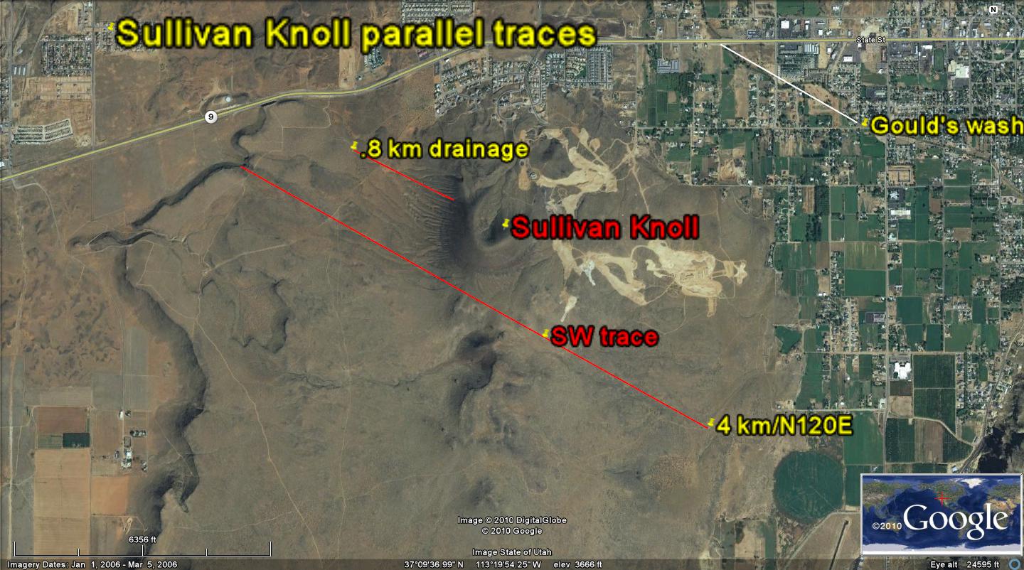 ABOVE IS AN EXAMPLE OF AN ARCUATE COVE, WITH A DIAMETER OF 20 METERS, AND ONE OF THE SMALLEST FOUND; POSSIBLY IT RELATES TO THE PRECESSIONAL ROTATION.
Another one is located south of I-15 freeway, as shown in the following photo:
 NOTICE THAT THE SHEAR INDICATIONS ARE CW, FROM THE THRUSTS. THIS MUST BE CHECKED FOR OTHERS, SINCE ONE "NORMALLY" THINKS OF BATH TUB DRAINS AS ROTATING THE WATER CCW AS IT IT SPILLS. ONE CAN REVERSE THE WATER DIRECTION MERELY BY PLACING A FINGER IN THE STREAM, SO IT SEEMS A WEAK FORCE, BUT IT IS OMNI-PRESENT, NEVER CEASING SO LONG AS THE EARTH ROTATES.
I will locate these on Google Earth, for Latitude and longitude, so that they can be centered within a Milankovitch cycle (hopefully round and not elliptical). Below is a larger one, named the Devil’s sink or throne, south of Mesquite, NV. This is found at 36 42'49.31"N latitude, 114 3'26.1"W longitude:

ITS AGE IS CALCUATED FROM A "ROUND" QUATERNARY FEATURE, SHOWN IN THE FOLLOWING PHOTO SOUTH OF THE VIRGIN RIVER, NEAR THE TOWN OF MESQUITE, AND OFF OF THE PAVED ROAD TO GOLD HILL. I HAVE AN ERROR POSTED FOR THE RATIO OF DIAMETER TO WIDTH OF The SINK; IT SHOULD BE 20 km/.03km= 600, and this ratio has not been calculated elsewhere, so is SUSPECT:
Notice that there is a tremendous disparity in size, and this should be correlated with the diameter of the orbital cycle which created it (large sinks should have surrounding them circular shear patterns in the rocks of at least 20 km diameter).