Path of the Sun, illustrating a Figure 8, is shown below, ARTIFICIALLY:

DIAGRAMMED, Mars requires 1.88 times Earth's year to Orbit, being further from the Sun. The path scribes a Figure 8 in a complete Orbit, when viewed from Earth's Neighbor.This scribing (cuts, as with an etching tool) SHEARS outcrops in the Earth's Crust in an ELLIPTICAL Pattern also:

Venus photos show Figure 8s on its SURFACE:

COLOR CODE is as follows: red, for COMPRESSION or Rising; blue for EXTENSION or Sinking; black for FACTUAL Information; Pink for scenarios; yellow for location or OUTCROPS; green for measurement, and white for N-S linears.
An ANALEMMA is the PATH exhibited by the ORBIT of one Solar mass (Body, Planet or Asteroid) around another in an ORBITAL year.This can be observed on Google Earth as a Partial Figure 8, e.g. for the Virgin River at a Great ANOMALY- the Hurricane Fault, Hf:

MAGNIFIED to view the Vertical OUTCROP at the Virgin River Power Plant. A scarp's Tilted sink rotates CW, with a CCW Rise which lies above its Elevation in an Outcrop; this is the case shown, where both Meanders are ERODING the outside BANKS of the river for a CW rotation of the Entire Reverse "S":

Above ANOMALY can be accessed for Hiking, by taking the Confluence trail at the Laverkin side, at the end of Center Street (turn south at the Traffic Light on Highway 9). This is further enlarged to find the adjacent METAMORPHIC Rocks:

Should you believe that above photos exhibit nothing but simple MEANDERS, look at the FORWARD "S" on the RISING Virgin River's uphill PART, above the Hurricane FAULT (crossing of the UPLIFT of the Colorado Plateau, Cp):

Below is a Figure 8 in a wall Rock, FRESHLY EXPOSED after the hill has been Blasted (Mining). The RATIO of Diameters of the 2 parts of the Figure 8 is 16/10= 1.6, which is APPROXIMATELY that for Earth days per year/Venus's days per ORBIT= 1.62:

Above Figure 8 at 48.47082N 122.640775W yields: (90, 1.221; 180, 2.194 ratios, for 1.19 S-J and 2.16 Moon/Sun, with 2 to 3% error).
DETAIL of the UPLIFT Fault or FRACTURE:
.jpg)
Similarly to the SINKING Analemma, the river erodes on the OUTSIDE of the banks; this produces a CCW Rotation with Time! EROSION is working in concert with Lateral Gravitation MOVEMENT to yield a SHEARING Rotation, CCW (Uplift), of the river PATH! In other words, the Colorado Plateau is STILL RISING, while the Hurricane Valley is SINKING NOW!
Here’s how UPLIFTS (Rises) and Basins (sinks) are formed (including their relation to an ANALEMMA):
1. While Planets move around the Sun in Elliptical Orbits, ALL of them exhibit Inclinations to the Ecliptic plane; these small angles allow the body to move AWAY from the Ecliptic and allow the Planets to individually, Gravitationally, Attract portions of the Earth’s Crust (when they orbit oppositely to the position of the Sun from Earth- both are on opposing sides of Earth). This attraction creates UPLIFTS, according to their Mass/(separation from Earth) squared.
2. During the Planet's elliptical orbit (at least half of the Time) there is Lateral movement somewhat PARALLEL to Earth’s orbit; this creates SHEAR;
3. During CONJUNCTION of Sun and Planet, there is combined attraction to PARTS of the Earth, creating Basins on Earth next to Uplifts (RISES were formed when the Sun and Planet were in OPPOSITION);
4. All Planets create this Rising and Sinking, while some create interference with others; this creates Elliptical COMBINATIONS, where rises and sinks may be ADDITIVE, or they may OVERLAP (see Inclination Angles from the Ecliptic and Planetary ORBITAL Planes in the following DIAGRAM);

and,
5. Additive ADJACENT movements yield a side-by-side set of ellipses, which in the simplest case is a Figure 8, with a ratio of diameters of the ratio of days of Earth Orbit/days of Planet orbit, which in the case of Venus is 1.62. This Figure 8 is an ANALEMMA, with a ratio of the two diameters dependent upon the Planet and its separation from earth and its Mass squared.
NOTE, here is a VISUAL METHOD that you can use to compare EARTH TIDES to Ocean Tides, by watching the coming and going of SALT WATER, as it oscillates at the Beach while you fish for Salmon:
Starting with the Full Moon, where the Moon and Sun are on OPPOSITE Sides of the Earth, note that there are 2 MAXIMUM Ocean TIDES Daily. At FULL Moon time, at 9pm (Moon is completely ROUND, since the Sun shines on it with NO interference from Earth Blockage, except for an Eclipse), the Maximum Moon high tide occurs (called Sun and Moon OPPOSITION). Within a few hours, the ocean will have advanced to your Beach Position at its Highest Elevation! Use AVERAGES and Time is allowed for the DELAY in reaching your fishing spot, because of constrictions in the PATH (such as narrow inlets).
12 hours of Elevation CHANGE, from the lowest level, comparing Moon High Tide to Sun High Tide, will effect 2.16 times as much Height change, since this is the RATIO of Moon’s GRAVITATIONAL ATTRACTION compared to the Sun’s. This is related to the Mathematical Relation: Force= a Constant x Mass of a Solar Body/(separation distance) squared, and while our Moon is much smaller than the Sun, it is MUCH CLOSER!
At 9pm, two weeks later at New Moon, the Moon and Sun will be at CONJUNCTION (both on the same side of Earth), and the Combined ATTRACTION will be on the opposite side of the Earth from you. This results in a LOW TIDE, since the earth has pulled inwardly from you. This is called a depression, basin, or SINK (in Earth Tides).
SIMILARLY to Ocean Tides, but much smaller, are EARTH TIDES' moveaments. These create RISES and SINKS with inverse MAGNITUDES of the Viscosity RATIO of Rock/water, which is LARGE! The resulting Rate magnitudes are near millimeters yearly, for Rock, compared to meters 4 times-daily for water (4 x 365 days x 1000 mm/meter yields a 1,460,960 ratio).
Between Highest and Lowest TIDES for the 2 weeks between Full and New Moon, the Moon follows a PATH which is somewhat adjacent to the Earth’s, and the result is SHEAR, forming CIRCULAR or Arcuate designs on the Earth Crust's Rocks- a Partial Figure 8 (ANALEMMA).
 (Full Moon occurs on September 9/2014, above; New Moon at 24 September)
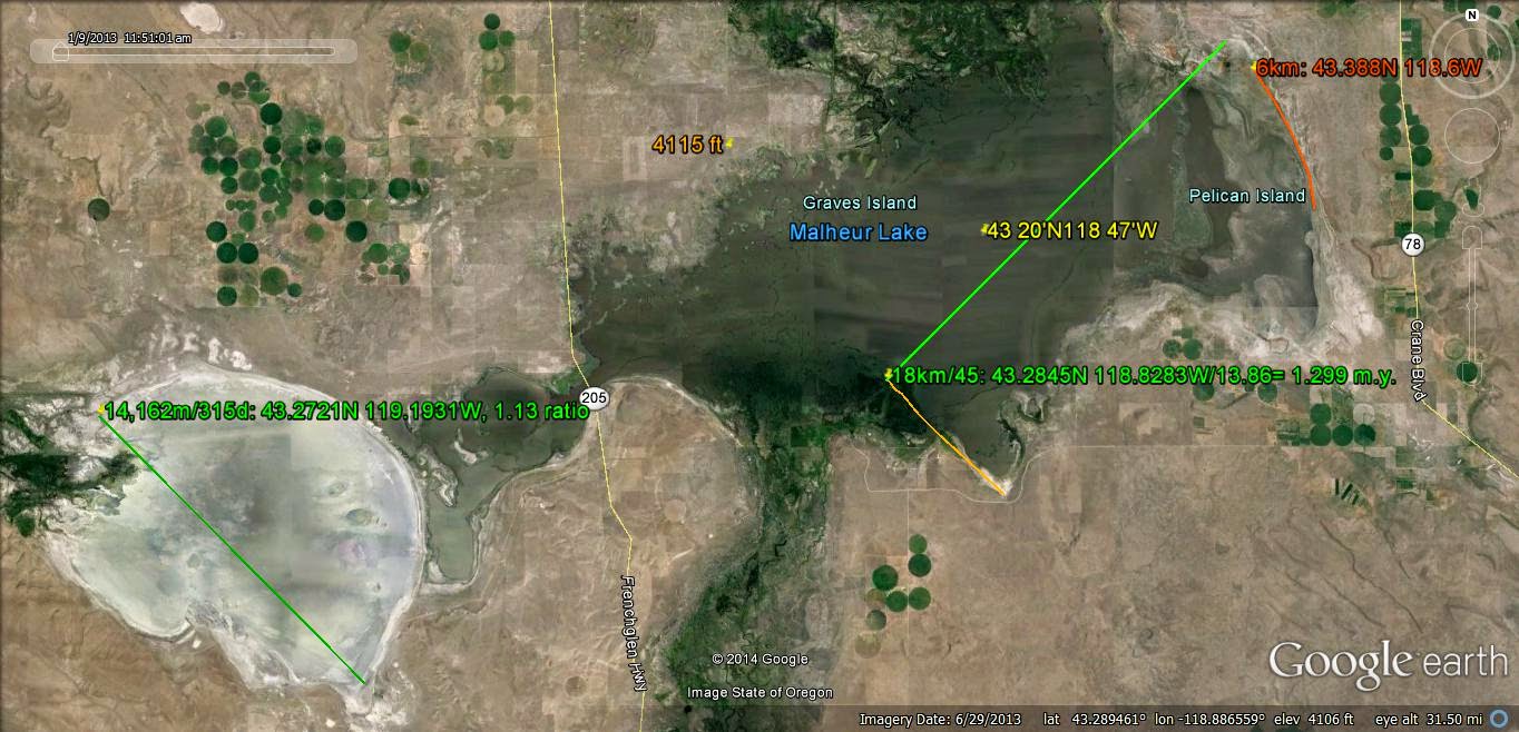
ELEVATIONS are shown for the 2 Lakes:

A better example is for ELLIPTICALLY-shaped OUTCROPS (Note the SLICE, called a Terrace or Outwash Plain by Geologists, that SEPARATES the 2 Arcuate Outcrops):

Hand SAMPLE exhibits Multi-shearing in a Figure 8 PATTERN, with a DIVIDER separating the Circular Axial (LARGER) part from the irregular Precessional portion:

Note that the DIVIDER is incomplete, since it ^ initiates another CW Rotation, RIGHT Side above!
Digital PHOTO of Checkerboard Mesa, which is a SUPERMOUND, of an approximate 41 k.y. Milankovitch AXIAL cycle:
.jpg)

I have followed the Path shown on Google Earth, which is a SET of adjacent LINEARS leading from the ALCOVE to the adjacent (present) mesa, and which RETURN to the Alcove. This represents an ORTHOGONAL ARCUATE Turn shown on the west side of Checkerboard. leading to the Alcove. Three DIMENSIONS would present this ERODED MASS as an ELLIPSOID, which has been eroded and carried away through the stream valley and by the winds. I speculate that there was removed, also, an ellipsoid of the OUTCROP which is now where State Highway 8 occurs on a terrace! This can be CHECKED by examining other Amphtheatres, such as the one at Red Canyon State Park, in a Jn almost-vertical outcrop:

ENLARGED:

ALCOVE is left of the Quail Creek SLOT or SLICE, in center of photo:

The above Anticline exhibits ARCS which have smaller arcs within the SCARP; each of these has cycles of Erosional slices (canyons or slots) formed by WATER and WIND. Erosion paths are determined in advance by Lateral CIRCULAR sheared zones, formed by ROTATIONAL SHEARING. The LARGER Scarp, viewed as a vertical figure, is a half Figure 8, or Partial ANALEMMA (look broadly, across the TOP of the photo diagonally)!
Red Cliffs Park is within Part of the Virgin ANTICLINE:

Also on the St. George, UT Sand Mountain RISE, there is an ANALEMMA, within a Larger ELLIPSE; notice that the SLICE is exhibited Along-side (the dark line), and NOT within the Figure 8 (the lower grey outcrop):


Notice that the forested Mesa cap, in CONJUCTION with the Alcove, is a Figure 8 with a linear DIVIDER; the linear approximates N30E orientation.
Re-measured, with Elevation of 6610 feet:

NOTE: There are at least 12 of these Mesas formed from an original CONTINUOUS vast Sand Dune deposit (Navajo or Aztec, in NV), and each of these has been "sheared off" at different starting TIMES (forming differing DIAMETERS, West to East). The IMPORTANT one is that which exhibits BOTH the Axial Cycle of 41 k.y. (Milankovitch's Cycle for completion of one Flat and LEVEL revolution, NOT an Orbit, but a 360 degree movement of the AXIS of the "spinning TOP" with its 41,000 Yearly earth ORBITS) and an Approximate Precessional cycle of 23,000+ ORBITS, yielding 41 + 23 to 25 thousand years total! These cycles may be CONCURRENT, with overlapping Time INTERVALS. The smaller Rotation may occur SIMULTANEOUSLY (forming an ELLIPSE of 41 k.y.), or it may be ADDITIVE (yielding a 64 k.y. Time INTERVAL). A Time INTERVAL of 100 k.y. will yield the ELLIPTICAL Cycle of Milankovitch.
The most IMPORTANT Mesas are the ones shown above, and the west one has ALREADY formed an ANALEMMA at its top SURFACE (see the 2 ellipses above the Alcove, or the Hole-in-the-Wall). Therefore, it will have a TIME INTERVAL of at least 64 k.y. if there is NO OVERLAP of time intervals (IF NO overlap, this"fits" the Binary Theorem of 2, 4, 8, 16, 32, and 64 units!).
New Concepts in Global Tectonics may be followed at: www.NCGT.org/
Checkerboard Mesa, shown with North to the RIGHT, is developing in two parts: an AXIAL Cell of estimated AGE of 41 k.y. (shown by the immediate Mesa Neighbor to the east), and an ANGULAR PROTRUSION to the South, which portrays the Milankovitch PRECESSIONAL Cell of 24.4 k.y. (65.4- 41 k.y.). This approximates the 24.4 k.y. Equinoctial CYCLE of the Precession of Earth's Tilt.
Compare above Google Earth photo with the neighboring Mesa to the east:

The TRIANGULAR-SHAPED Mesa top will ERODE on its left side, in an ARCUATE movement, and this will form an Arcuate Figure, an Analemma- one part RISE (original bedding, uneroded), and the other an eroded "hole" or SINK!
This Mesa has been measured and AGE-calculated, to show how its 6630 feet maximum Elevation has eroded LESS than adjacent Checkerboard Mesa (both are Jn, Navajo sandstone):

Since this Mesa has a Calculated AGE of near the Milankovitch 41 k.y. Axial CYCLE, it represents an excellent opportunity to determine HOW the eroding sandstone develops an ANGULAR part NOT EXISTING in this younger Mesa!

Mesa to East:

Neighbor to East, with 6570 feet Elevation, is NOT as tall as Checkerboard, i.e. it has been eroded more! Since its calculated AGE is less (near the Axial cycle of 41 k.y.), it cannot develop an angular turn via less erosion of a lower-in-elevation stratum. This hints that the angular portion of Checkerboard has somehow DEVELOPED to the west, after the more linear portion has developed in the first 41 k.y! My assessment is that EROSION removes part of the WEDGE, making it a more LINEAR portion (oldest), and an original REMNANT, appearing as a backwards "L" shaped entity overall.

This MYSTERY is partly solved, by noting that there is Selective EROSION. There is an ARCUATE uneroded development to the south, allowing the angled-off Precessional cell to be initiated, as a "Hole" above.
Below is a VIEW into the CANYON between them:

The Hole-in-the-wall is related to the development of the Precession to the East. This relates that Greater shear occurs in the Canyon, while the Precessional with less erosion develops! Look at the Alcove closer:

The TURN at the side of the Mesa may be more easily VISUALIZED with the following Rock Sample, which has been SUBJECTED to Gravitational SHEAR and Rotation on the 1/1,000,000 scale. The ELLIPSE (LARGER Part) is near 3 to 4 times the width, and the Longer/smaller axis is at least 3x:

SLICE separates the ellipse from the smaller "TIT", similarly to the smaller Sink of Checkerboard Mesa forming to the west. The Ellipse forms FIRST, but more SLOWLY; the Tit may be a Rise Shown with the rock sample, or a Sink, shown at the Mesa!
The TOP of a pinnacle, which has fallen to the Watchman trail, Zion NP, Utah illustrates how a DIVIDER (tilted slice through the stratigraphic Column) separates the two parts of a Figure 8:
.jpg)
Checkerboard Mesa TURN:

Viewing the TURN of Erosion toward the Alcove:

Above is the SLICE (Canyon) HOLE (Alcove) arrangement, showing that the slice BORDERS the hole. The N-S CANYON is Moon-related, while the Hole is a RETROGRADE phenomenon, on the 1/1000 SCALE.
Nearby Peaks, in the ELLIPTICAL Arrangement:

Zion Checkerboard Neighbors, East:

LENGTH of the Fault N-S indicates that it was Gravitationally sheared by an ASTEROID, where 456.51/111.111= 4.1 degrees Inclination (largest Planetary I. = 3.39 degrees, 1/1.62 years for Venus, and Jupiter has 1.304 degrees, with 11.86 years Orbit) and where the previous Mound's rotation was influenced by Jupiter and Neptune.

Mesa to the east:

Using a better computer, another Mesa to the east is shown, to determine if it is Younger; all those to the east should have been INITIATED Later:

Mesa NUMBER 6 is as close to the Milankovitch Axial cycle of 41 k.y. as I can measure; it is at the Eastern border of the ELLIPSE of N-S oriented Mesas. The ONLY entity to check now, is the TIME INTERVAL (whether the Uplifts have reduced the Lateral Tidal RATE to something less than 10.24- which is suspected whenever there is a Significant UPWARD Attraction)!
Mesa 6 to 5 exhibits SCRAPING (arcuate erosion, in White):

All this has been Photographed on a smaller Scale, for Jn at Washington City, near the I-15 Freeway; this is a PANORAMA, but the distorted Figure 8 is obvious:

An ANALEMMA develops with selective EROSION, because of the Gravitationally-produced FRACTURES, which form the PATH or which SHEAR in advance of EROSION:

The DIP of bedding is near 5 degrees, corresponding with the 5.145 degrees Inclination from the Ecliptic for the Moon, whenever the Orientation is near N-S. This feature is easily hiked, even to the summit:

You can now determine that Alcoves, Erosion PATHS, Holes, and Slices are "fixed" by selective EROSION, following Gravitationally-determined SHEAR PATHS!

INTUITION suggests that the Scale FACTOR of 1000 will yield Information for Man's LIFETIME: DISRUPTIONS should occur on the 24.4 year cycle, and possibly on the 2.44 year (24,400/10,000) cycle of the Moon, and the 4.1 (41,000/10,000) cycle of our Sun. The first should occur in September 2015, 2.4 years from the Ledgewood Full Moon SLUMP (destroying 4 houses) of April, 2013:
.jpg) EARLIER Slump is shown below, from 12 years prior:
EARLIER Slump is shown below, from 12 years prior:
 Two slumps have occurred at the Ledgewood beach; the one above slowly collapsed the Home, and the 2013 slide was SUDDEN- occurring during the Full Moon:

ORTHOGONALLY:

Sun CYCLE OF 4.1 years should create small QUAKES, along a Latitude line (parallel). This anniversary may occur after the Washington City Asphalt Trail collapse of 2011:

POSSIBLE vertical Shear may occur, as with this Scarp at the Honeymoon Trail spiral:
 Our Moon AUGMENTS the vertical RISES yearly:

ORTHOGONALLY:
Sun CYCLE OF 4.1 years should create small QUAKES, along a Latitude line (parallel). This anniversary may occur after the Washington City Asphalt Trail collapse of 2011:
POSSIBLE vertical Shear may occur, as with this Scarp at the Honeymoon Trail spiral:
Place your COMMENTS below; this requires IDENTIFICATION!