Wednesday, April 14, 2010

PERMIAN EXTINCTION, PTr (NOT EXTENSION) SHOWN IN THE MOENKOPI

EARTH SCIENCE postings from www.googleearth.com are reported in blogsites in: www.PorOgle.blogspot.com for other locations.
PHOTO ABOVE SHOWS THE TOQUERVILLE THRUST, WHERE A VIEW MAY BE MADE OF THE CONTACT OF PERMIAN LIMESTONES WITH THE OVERLYING MOENKOPI. A FAULT OCCURS, ALLOWING THE YOUNGER Trm TO BE SEEN IN A CANYON CREEK BED- GYPSIFEROUS BEDS FRON DESSICATION IN THE AFTERMATH OF THE PERMIAN STRIKE. WE WILL USE TOOLS SUCH AS SLICKENSIDES (BELOW) TO DETERMINE THE MOVEMENT OF SEDIMENTARY BEDS, SO THAT STRESS DIRECTION AND ORIENTATION MAY BE ASSESSED
GOOSEBERRY MESA IS ANOTHER LOCATION WHERE THE MOENKOPI IS EASILY HIKED, FOR INSPECTION OF THE STRATIGRAPHIC COLUMN (AND ITS CONNECTION WITH THE PERMIAN EXTINCTION- JUST PRIOR TO THIS TRIASSIC TIME):


WE'LL GET BACK TO THE LOCAL TRIASSIC, BUT FIRST WE'LL FIND IF THERE IS EVIDENCE FOR THE PTr EXTINCTION NEAR THE EAST INDIES (WHERE THE PATTERN IS SIMILAR TO THAT FOUND IN THE WEST INDIES, FOR THE KT STRIKE):


By analogy with the fairly certain strike offshore Yucatan- which left significant traces in the Gulf of Mexico- I will search for similar indications in the SE Asia region. The most obvious clues are:

1. The sink known as the Gulf of Mexico, itself;
2. The configuration of Cuba, which is a circular island with Mesozoic outcrops- arrested in its development by rising during the aftermath of KT;
3. The array of islands broken off from the continents, or West Indies;
4. Silting offshore Yucatan, evidently from fall-back of fragments; and,
5. The configuration of Central America (reversal of circular trends).

THERE IS ANOTHER CLUE IN THE YUCATAN REGION- DESTERRADA ISLAND. WE'LL RESEARCH THIS SMALL BIT OF INFORMATION AND SEE HOW IT FITS WITH THE IMPACT IN ROCK:
The difficulty in this task is with the TIME OF OCCURRENCE- WHERE 200 M.Y. HAS ELAPSED SINCE THE GREAT EXTINCTIOIN TRANSPIRED. During this time interval, Coriolis re-arrangements have occurred, the KT strike has had a world-wide reaction (life has made major adjustments- interacting with the EARTH, CREATING CHEMICAL AND BIOLOGICAL WEAHERING, the Equator has shifted (because at least 10 degrees of polar wandering has transpired), and the Earth has slowed, reducing EB, contracting the earth, and uplifting linear mountain ranges.
The Celebes Sea fits the requirements, for similarity to the Gulf of Mexico, the occurrence of many islands, the circular arrangement of the sea, and presence of silting- even though the sea is as much as 5 km deep.
Chicxulub is not an obvious exhibit for a model for an asteroid strike. It probably would not have been found except for rock-hounding in the search for hydrocarbons (shock rock is a god clue). I can’t see the results, except faintly, on Google Earth maps. Therefore the search for a pattern of island shape location, and three-dimensional changes (such as water depth, circular arrangements, and siltation) may be the best method of locating an asteroid crater- before doing geophysical work. Desterrada Island, Mexico
The only clue offered by the long-atrophied remains of the Chicxulub asteroid (A-Steroid?) strike is the small reefal island of Desterrada. This type of structure requires that originally there must have been a near-sealevel protrusion such as a volcanic mound or crater for growth of the coral reef. The island, being far to sea from Yucatan (22 degrees 24’N, 89 40’W longitude), has no indication of being connected to the mainland, and seems to be removed from anything analyzable. The only information useful for larger involvement other than that of a simple reef is that of the well water composition. It is highly anomalous in HCO3- ion, indicating that it has been de-composed by bacterial activity or heat of decomposition from the reefal CaCO3, according to the relation:
CaCO3+ 2H2O + CO2 > >Ca++ and 2HCO3-
There are some intermediate steps to this relation- this being the end result, requiring a change of acidic pH first to dissolve the limestone and later create alkalinity. The acidity can come from the rain or from subsurface heating to bake off the gas. Regardless, the island must have been near the surface to form the reef- with the action of Life.

PRESENTED BELOW IS ANOTHER (LARGER) VIEW OF THE ISLAND OF DESTERRADA, MEXICO- WHICH MIGHT YIELD A CLUE TO FINDING ASTEROID CRATERS FROM SEA BOTTOM DISRUPTIONS IN THE NW AUSTRALIA OR CELEBES SEA AREA: PHOTO BELOW SHOWS THE DECCAN TRAPS- WHERE A MOUND OF CRUST, REACTING TO THE PERMIAN STRIKE (UNDER THE INDIAN SUBCONTINENT AT THE TIME) CREATED A MASSIVE FRACTURING AND SUBSEQUENT FLOODING OF BASALT AT ABOUT THE PERMIAN STRIKE TIME OF 250 M.Y. AGO:
THE "BIG PICTURE" OF THE EAST INDIES (WHERE I LIVED FOR 3 YEARS) IS SHOWN BELOW, AND A VIEW OF THE DECCAN TRAPS- WHICH ARE PROBABLY RELATED TO MASSIVE OPENING OF THE CRUST DUE TO THE ASTEROID STRIKE:
ANOTHER POSSIBILITY FOR AN ASTEROID CRATER IS IN THE WEST AUSTRALIA BASIN, WHERE THERE EXISTS A SINK WITH SOME FRAGMENTED ISLANDS:

The Montebello (NW Australia- where I was involved in the atomic testing military program in the 50s) location and nearby anomaly to the north is a prime candidate for an asteroid strike, more so than the Banda Sea. It has considerable siltation adjoining an obvious fault linear on its South side. The one caveat is the centerline linear, which I have generally found is related to an independent movement. This could be augmentation of a dynamic feature such as an asteroid strike, but it could indicate a Coriolis rotation; however, the occurrence of a linear on its southern boundary may be supportive. I have tracked Australia, and it moves to the NE, after the KT strike at Chicxulub, so that the linear on the south side would not be expected to be related to Australia dynamics. This could add to the possibility that the whole feature is related to an independent dynamic- such as a strike.
ANOTHER INTERESTING FACTOR IN THE STUDY OF AUSTRALIA PHENOMENON OF ASSOCIATION WITH AN ASTEROID STRIKE, IS THE APPEARANCE OF SEVERAL ENTITIES WHICH ARE SIMILAR TO THOSE IN THE NORTH AMERICAN QUADRANSPHERE:
1. A "WASATCH LINE" SEPARATING THE CONTINENT IN TWO CIRCULAR ROTATIONS;
2. A NEW ZEALAND "YELLOWSTONE", DIVIDING THE ISLANDS IN TWO PARTS AT THE 40S EQUATORIAL BULGE TERMINATION BORDER (USA TRACK LIES ABOVE THE 40N EB BORDER);
3. A LINEAR MOUNTAIN RANGE- THE OWEN STANLEY CHAIN- IN NEW GUINEA; AND
4. THE ASSOCIATION OF THE TRIPLET OF THE 3 ENTITIES ABOVE, SIMILAR TO THE B&R, CP, AND SIERRAS COMBINATION OF FEATURES WHICH INTERACT WITH EACH OTHER (AND ARE INTER-RELATED).

CONSIDERING THAT THE ATLANTIC OCEAN MAY HARBOR CLUES TO THE POSSIBLE STRIKE OFFSHORE AUSTRALIA, LOOK AT THE CHANGE IN THE INFLECTIONS IN THE TRANSFORMS IN THE ATLANTIC BASIN; IT APPPEARS THAT THERE IS DRASTIC CHANGE IN THEM WHEN APPOACHING BERMUDA (A CLUE TO THE NW-TRENDING CRUSTAL MOVEMENT TOWARD APPALACHIA):

ALSO LOOK AT THE LOCATION OF BERMUDA, AND INVESTIGATE WHETHER IT OCCURS DUE TO A POSSIBLE PERMIAN STRIKE ON THE OPPOSITE SIDE OF THE EARTH: Enlarging and homing in on Appalachia and its NE-SW TREND, there is more information on the association of the transforms offshore and the Permian strike:
THE LOCATION ON THE OPPOSITE OF THE EARTH FROM THE BERMUDA LOCATION IS SHOWN OFFSHORE PERTH, AUSTRALIA- EXHIBITING A CIRCULAR ANOMALY AND SILTED AREA AS A POSSIBLE 3RD LOCATION FOR A PERMIAN ASTEROID STRIKE IN THE GENERAL AREA:

Australia, cont’d
Solving the problem of the Permian extinction, related to an asteroid strike and the traces left on Google Earth ocean basin floors requires that a judgment be made as to the predominant feature displayed (out of several):

1. The total pattern left on surrounding crust which has been broken into many islands;
2. The crater traces left, which must be contrasted with those made by Coriolis rotation, drag from linear movements- such as that at the borders of EB, and rotating crust between oppositely-moving fault planes;
3. Drastic movement along transforms, such as those along the Equator in the Atlantic;
4. Inflections in nearby transforms or lines of shear displaying discontinuities in their presentation; and,
5. Patterns of traces of transforms NOTED in the ocean basin, which have been overlain by succeeding ones due to the later KT strike.
Considering each of these in turn:
The West Indies (1), which seem to have been related to the K strike, are inferior to those in the East Indies, in terms of area covered, and this fits positively for the two general areas of Central America versus Australia and the East Indies. Most confidence!
The craters (2) seen are many, and allow too much subjectivity for important conclusions, concerning which is related to a Permian strike. Least confidence!
The slide along transforms (3) is best presented at the Atlantic Equator, and the only equivalence is noted to occur with siltation on the ocean bottom-which extends considerably near Australia to New Zealand. However, there is a lengthy slice in the Tonga trench, but this is so rapid and fresh that it should be eliminated due to its modernity. Intermediate confidence!
Inflections (4), which can be confirmed for two or more linears, are few, and can be given more confidence as to their relation to an Asteroid strike. Intermediate confidence!
Patterns of parallel transforms (5), which are overlain BY OBVIOUSLY YOUNGER PATTERNS are few, and the best example is that of the collision producing Appalachia- a NW thrusting. Low confidence!

BELOW ARE EXAMPLES OF THE CONTRASTING FEATURES, FOR ANALYSIS OF LEVEL OF IMPORTANCE TO LOCATING AN ASTEROID STRIKE:
Calculation of rates of Progression of the MAR westward from the West Coast of Africa:
The following analysis relies on several assumptions:

1. That both the drastic changes in fauna, inflection of transforms, and patterns of rifts and blocks of oceanic crust are determined by asteroid strike‘s- both for the Permian-Triassic boundary, PTr, and the Cretaceous-Tertiary EVENT, KT- extinctions and disequilibrium of the Earth’s crust;
2. That the older PTr is discernible on the ocean floor via Google Photos, and that it may be seen to be obscured by the younger KT traces;
3. That the present movement rate may be calculated by measuring distances between major inflections and the present MAR on the Google earth map and then dividing this by the age of the KT boundary;
4. That the movement rate is constant over the distance and period for a segment of the Earth’s Crust; and,
5. That the movement rate calculated by this method is appropriate for earlier events- such as the PTr strike-induced rearrangement of the Polar Axis and position of the Equator.


There is a significant angle of departure from the present orientation of rifts orthogonal to the MAR, to that noticed (evidently) creating the Appalachia collision with its NW-SE orientation. This is assumed to be a result of the PTr extinction and compression of Paleozoic sedimentary rocks parallel to the east coast of North America. This angle of at least 30 degrees is significantly at variance with the present shear along latitude lines, and will be assumed to be discernible from (and obscured by) the more distinct traces. Using the start of this departure as the initial measuring point, the photo below yields a movement of rifts of 18 mm/year (westward). I have found that this is usual for the entire globe- that the tidal friction creating slowing of the crust has a due westward component, even when the island or crustal segment is oriented away from a N-S arrangement (e.g. the Sierras). Behind this finding is the next assumption that the westward movement is steady, so long as there is NOT another mechanical disturbance, such as an asteroid strike or close encounter with another body from SPACE.
This calculated movement of the MAR westward can now be used to determine the time since the west cost of Africa separated from the MAR. Using the constant rate of 18 mm/year, for the preceding earth arrangement, and the measured 2958 km distance between Africa and MAR (including the silted area- which is evidently created by the PTr disturbance preceding the KT strike), the calculated age of the of an earlier strike is found to be 165 m.years. This is short of the expected 250 m.y., but is encouraging in that it is at the approximate time (Jurassic, instead of Permian). Should all the other assumptions be essentially correct, this would indicate that the 18 mm/year rate is too large; 11.8 mm/year would yield the expected separation.
A MAJOR CONCLUSION: THE ASSUMPTIONS ARE CORRECT ENOUGH TO JUSTIFY THE PROCEDURE. The average movement rate has been influenced by the average of NO significant movement at the top of the BULGE (where westward movement has been offset by eastward movement of a CW-rotating cell in the Atlantic, about the 38N Latitude), compared to the Equatorial transforms tracing E-W at double the rate of that used in the calculation.
BELOW ARE SOME PHOTOS WHICH YIELD INFO ABOUT THE TRIASSIC, AND ITS ARTIFACTS:

QUAIL LAKE HAS TRIASSIC SHINARUMP (LOCATED ABOVE THE MOENKOPI FM.) WHICH EXHIBITS FOSSIL TREE LIMBS AND TRUNKS, AND SLICKENSIDES FOR DYNAMIC ANALYSIS):


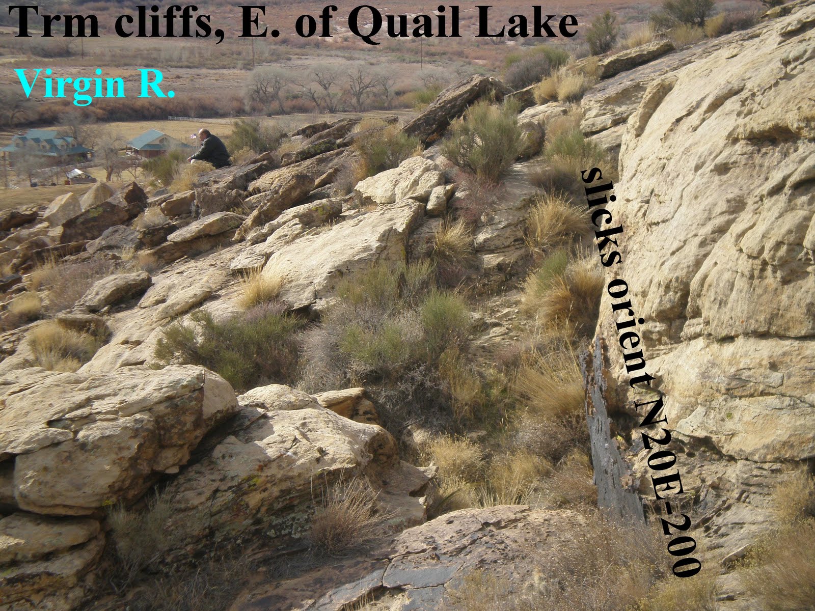
ANOTHER LOCALE WHERE WE CAN STUDY THE MOENKOPI AND ITS CONNECTION WITH THE PERMIAN EXTINCTION IS THAT AT THE KAIBAB-MOENKOPI CONTACT FOUND AT THE TOQUERVILLE BLOCK FAULTING, E OF TOWN: THE MOENKOPI FORMATION IS SHOWN, WHICH CONTAINS INFORMATION OF SEVERAL TYPES, IN THIS ASH CREEK DRAINAGE- WITH ITS UPLIFTED TO THE EAST BLOCK FAULTING:
1. THE LOCAL STRESS DIRECTION IS SHOWN BY THE FRACTURE ORIENTATION;
2. THE TYPE OF ENVIRONMENT- EVAPORITIC BASIN, WITH GYPSUM- AT THIS EARLY TRIASSIC TIME CAN BE SEEN;
3. THE UPLIFT, WHICH IS UP TO THE EAST, BACKWARDS FROM MOST B&R FAULTING AT THIS LATITUDE ALONG THE B&R LATERAL FAULT (WEST OF THIS LOCATION), IS SHOWN; AND,
4. SEEPAGE OF WARM WATER CREATING GYP ROSES (PSEUDOMORPHS) ARE FOUND NEARBY, AT INFLECTIONS IN THE STRATIGRAPHIC COLUMN.


BELOW IS THE TOQUERVILLE THRUST, SHOWING Pk DIPPING DOWN TO THE WEST, UNTIL A CROSS FAULT IS ENCOUNTERED TO THE SOUTH; THEN MESOZOIC MOENKOPI, WHICH LIES ABOVE Pk, IS SHOWN. THIS IS THE CANYON WHICH CAN BE USED TO VIEW THE MOENKOPI IMMEDIATELY ABOVE pK (WHERE THE GYP BEDS AND THE EXTINCTION OCCURRED):


THIS TREATISE IS IN PREPARATION; SCROLL DOWN FOR INFORMATION LEADING TO THIS MISSIVE.

Sunday, April 11, 2010

Divergence of two or more Great Faults creates Extension and Vulcanism

EARTH SCIENCE postings from www.googleearth.com are reported in blogsites in: www.PorOgle.blogspot.com for other locations. ABOVE IS A PHOTO SHOWING ZION NP, AND BELOW IS THE WIDER AREA TO THE WEST, WHERE THE DIP OF THE TOQUERVILLE FAULT BLOCK IS DOWN TO THE WEST (REVERSE TO MOST BASIN AND RANGE FAULTING- WEST ALONG THE LOWER PART OF THE B&R IN NEVADA). NORTH IS TO THE RIGHT IN THIS LOWER PHOTO:


This case will be exemplified by the divergence of the Basin and Range, B&R, fault and the Hurricane fault, Hf, near the Anderson Junction at I-15 Freeway near the town of Toquerville. This area has State road 17 which exits I-15 southward along Hf. Black Ridge is a ramp of basalt which has a steep section requiring some switchbacks, to descend into the Hurricane Valley. All of this area may be accessed and photographed from the road, but some is private land not allowing crossing the fields and outcrops.
My conclusion regarding small volcanic vents, which are numerous near Hf, both on the east and west sides, is that they are created by FRICTION OF BRITTLE ROCK (that is, the Crust), whenever the lithosphere above the mantle rotates against the wall rock. Should the rock be rising, as with an emerging magma, it spirals counter-clockwise, CCW. This is not the normal case, since most crust is sinking or shrinking due to contraction and slowing with time- due to tidal friction from the gravitational attraction of the Moon. This effect has caused parts of the crust to sink when they are lower in elevation than surrounding crust. The opposite effect incurs from higher than normal elevation, such as mountains salt domes, or protrusions- that is, CW rotation of part of the crust. The case of sinking occurs for the B&R, because it is lower in elevation than the Colorado Plateau, CP, relatively. The broad result is a rising CP and a sinking B&R- creating the Wasatch Line, which has both masses moving to the south at their common boundary. They are in harmony, except for differences in velocity, along the Wasatch Line, but pull apart at the Black ridge, Anderson junction, and along I-15 freeway turning towards St. George to the SW. We will study this case, using Google Earth mapping, field observations, and locations of basalt vents- which are emplaced by extension at the divergence of the two faults.
Below is the location map for this area, AND AN ENLARGEMENT OF THE IMMEDIATE AREA TO THE NORTH- THE WET SANDY ARCUATE CREEK AND SURROUNDING MESOZOIC SEDIMENTARY AND INTRUSIVE REMNANTS:
BELOW IS A GOOGLE PHOTO, WITH MY PRESENT ANALHSIS OF FACTS TO BE CONSIDERED FURTHER:
Both the Google Map and my interpretation of major features on a separate map are shown above and below. It appears that the occurrence of the large block fault east of Toquerville is due to the extension created by the divergence of the two great faults (Hf and B&R), and that the saw-tooth in the block’s edge is due to the difference in velocity of movement of the two faults. I am trying to measure these, and it appears that Hf is moving near .5 mm/year, compared to B&R moving somewhat less- creating the jagged edge of the block fault scarp. Ash Creek follows the most westward splay, while Laverkin Creek follows the one to the east. The creeks never junction, but follow separate paths until reaching the Virgin River- some 100 meters or so separation at the narrowest. This occurs, because of the two fault systems- Hf influences the one to the east and B&R determines the one to the west- due to the two velocities of movement (rotation , with two different diameters of cells).
What determines the direction of tilt of fault blocks: up to the west (older sedimentary beds high on the west side)- which is most common, or up to the east, which is the case for the Toquerville block faulting east of town- the sliver of crust between two splays of Hf? Below is shown the case of the Beaver Dam Mountains, BDM, which has Cambrian exposed to the west:

BDM is a monocline, created by the westward shove of the B&R lateral fault, which stretches from the Wasatch Line toward the Valley of Fire, NV. There is compression from the east, caused by the CW rotation of this whole B&R region. The transition zone, which BDM terminates, starts a major depression or sink, and Littlefield is obviously at a low elevation referenced to the CP and land to the east. The Muddy Formation of LATE TERTIARY TO Pleistocene age has eroded from the BDM, and the youth of the feature is another puzzle to be solved. Why has the BDM risen so rapidly and so recently?
Back to the Toquerville fault block and its tilt down to the west, this is a segment of Crust which is under extension (as shown by the numerous basaltic vents which rose just ot the west), and its tilt defies the notion for much of Hf that the Mantle is dragging the base of the Crust to the east; this is being dragged oppositely! For this case, B&R fault is dominating the action; Hf is moving southward, but the B&R lateral fault is dragging westward, and the result is that the block is moved subsurface to the west, while rotating southward (CW) by Hf.
SOLVING THIS PUZZLE REQUIRES THAT I RESORT TO A MODEL, TO ELIMINATE SOME OF THE COMPLEXITY. BELOW ARE PHOTOS AND DIAGRAMS TO HIGHLIGHT THE IMPORTANT FEATURES:

BELOW ARE SOME PHOTOS OF IMPORTANT DETAILS, FOR LATER INTERPRETATION OF STRESS AND ASSOCIATED DIRECTIONS- WHICH WILL HAVE A BEARING ON PORTIONS OF THE GREAT ROTATION SHOWN FROM LITTLEFIELD CREEK TO THE VIRGIN RIVER TO THE Hf AREA (BOTH WITHIN THE BOUNDARIES OF THIS FAINT, BUT YOUNG DEVELOPING CELL- YOUNG BY VIRTUE OF THE LATE TERTIARY TO QUATERNARY AGE OF THE MUDDY FORMATION, NOW FORMING ON THE WESTERN BOUNDARY FROM EROSION OF THE YOUNG SCARP ON THE WESTERN EDGE OF BDM):
AT THE EASTERN EDGE OF THE SINKING CELL, THE RATIO OF N-S TO E-W MOVEMENT IS 1/2, WHICH IS A FOURTH OF THAT CALCULATED FOR SAND MOUNTAIN MOVEMENTS. THIS TELLS THE STORY THAT THE MOVEMENT WESTWARD OF CP IS TWICE THAT OF THE SOUTHWARD ROTATION ALONG Hf. IN OTHER WORDS, THIS GREAT CELL (FROM LITTLEFIELD TO CP) IS RAPIDLY FORMING TO THE WEST- MOVING TWICE AS FAST AS THE COLORADO PLATEAU IS ROTATING. THIS IS CALCULATED TO BE 700 KM/41 M.Y. OR ABOUT 17 MM/YEAR. THIS MUST BE SUBSTANTIATED BY SOMETHING OTHER THAN MOVEMENT WESTWARD OF BASALTIC VENTS, BUT FOR NOW THIS RESULTS IN THE BDM SCARP MOVING SOME 34 MM/YEAR, WESTWARD. THIS PARTIALLY EXPLAINS WHY VALLEY OF FIRE PARK, NV HAS MOVED WESTWARD IN THE TERTIARY.


NOTE THE ORANGE MESOZOIC SANDSTONES, COMPARED TO THE HIGHER-IN-ELEVATION AND OLDER PALEOZOIC LIMESTONES IN THE VALLEY OF FIRE STATE PARK, NV:


I AM WORKING FROM MEMORY, AND NOW MUST HIKE INTO THE ASH CANYON EAST OF TOQUERVILLE, TO SCAN THE BLOCK FAULTING THERE. THIS IS A BLOCK WITH TWO SCARPS- ONE FORMED BY THE ASH VALLEY, ANOTHER FORMED BY THE LAVERKIN SPLAY TO THE EAST. SIMULTANEOUSLY WE WILL SCAN THE MOENKOPI FORMATION IN THE CENTER OF THIS, TO DETERMINE THE RELATION OF THE GYPSUM FLOWERS, SLICKENSIDES, AND SEEPS TO THE UPLIFT THERE. THIS GREAT AGE OF DESSICATION, LOSS OF FOSSILS- DUE TO THE PERMIAN EXTINCTION, RED BEDS- DUE TO INTRODUCTION OF COPIOUS AMOUNTS OF IRON, AND INLAND LAKES OF SALTY WATER WILL BE RE-CONSIDERED IN TERMS OF THE THEORIZED ASTEROID STRIKE AT THE P-Tr JUNCTION.
I will now present a MODEL, WITH A LARGER PERSPECTIVE- SHOWING COMPARISONS OF TWO SEPARATE TRANSITION ZONES. ONE OF THESE, IN WHICH I HAVE MORE FIELD WORK, IS THE VERDE VALLEY GRABEN, WHERE THE ROTATION SINCE THE OLIGOCENE HAS CAUSED THE DRAINAGE PATTERN TO DIVERT FROM NORTH-EASTWARD TO SOUTH-EASTWARD. WE'LL WEIGH THIS CASE AGAINST THE ST. GEORGE FEATURE, TO DETERMINE WHETHER THE ST. GEORGE CELL IS LARGER THAN A SIMPLE TRANSITION ZONE:
FOR NOW, NOTICE THE FOLLOWING:
1. THE ST.G. CELL IS ABOUT 4X LARGER THAN THE VERDE GRABEN, HENCE IS TOO LARGE FOR A SIMPLE TRANSITION ZONE;
2. THE GREATER TILT OF THE ST. G. CELL RESULTS IN RAPID UPLIFT OF ZION RELATIVE TO THE MUDDY FORMATION AND ASSOCIATED SCARP TO ITS EAST; AND,
3. THERE IS A LARGE MONOCLINE- BDM- FOR THE LARGER SINK, AND THIS IS A RESULT OF THE B&R LATERAL FAULT SHEARING ALONG THE VIRGIN RIVER- ROTATING AND COMPRESSING THE ZONE TO THE WEST (PROTRUSION, WITH GREATER CRUSTAL THICKNESS AND SUBSEQUENT GREATER VELOCITY ASSOCIATED WITH THIS THICKER MASS). REFER TO THE FOLLOWING PHOTOS, FOR THE LOCATION AND IMPORTANT FEATURES- WHICH ARE SHOWN ON THE MODEL:


BELOW IS THE ST. GEORGE SINK (BASIN) RE-DRAWN, TO ELIMINATE SOME BIAS. SHOULD THE CANYONS- SHOWN AS OVERLAPPING- HAVE THE YOUNGEST IMPRESSED OVER THE OLDER, THE ROTATION OF THE CORIOLIS CELL WILL BE TO THE NORTHWEST (CCW, RISING). THE OLDER CANYON IS DEEP AND ENTRENCHED, HENCE MAY NOT RELATE TO THE PRESENT STRESS SYSTEM. IN THIS CASE, WE WILL HAVE TO ENTER THE PARK TO DETERMINE THE PRESENT ACTIVE SLUMPING AND INCISION (NOT NECESSARILY THE VIRGIN RIVER COURSE NOW): THE "FIT" OF THE CURVATURE OF A CIRCLE OF SHEAR, CREATNG THE PATH OF THE LITTLEFIELD RIVER AND THE YOUNGEST CANYONS IN ZION PARK, IS SHOWN BELOW; NOTICE THAT THE YOUNGER CANYON YIELDS A SHARPER IMAGE- INDICATING THE YOUNGEST IN AGE. WE WILL HAVE TO DETERMINE WHAT IS CAUSING THIS MOVEMENT, OTHER THAN THE PROTRUSION OF THE HIGHLANDS INTO THE ATMOSPHERE (CREATING A GREATER DRAG DUE TO THE INCREASED FRICTION OF TIDAL DRAG ON THICKER CRUST- SINCE UNTIL THERE IS A HIGHER ELEVATION, THERE IS NO IMPETUS TO INCREASE TIDAL FRICTION!): ONE FACTOR OF IMPORTANCE REFERS TO THE GENERAL OBSERVATION THAT THE MANTLE DRAGS THE BASE OF THE CRUST EASTWARD, DUE TO THE LESSER INFLUENCE OF TIDAL EFFECTS (SINCE IT IS FURTHER FROM THE MOON, AND HAS LESSER SLOWING WITH TIME):
This is shown in larger view, to see the "BIG PICTURE":
IT’S ALL FITTING TOGETHER, USING CORIOLIS ROTATION AND THE EASTWARD MANTLE DRAG OF THE BASE OF THE CRUST (acronym: MAD-MACS, MANTLE DRAG, MOUNTAIN-AUGMENTED CRUSTAL SHOVE):
1. AS THE ZION REGION RISES, IT ENCOUNTERS TIDAL FRICTION INCREASE- MOVING IT (RELATIVE TO LOWER ELEVATION SINKS) TO THE WEST;
2. THE HIGHLANDS CRUSTAL BASE ENCOUNTERS DRAG FROM THE EASTWARD MOVEMENT OF THE MANTLE, CAUSING THE ENTIRE REGION TO TILT DOWN TO THE WEST. THIS RESULTS IN A SINK TO THE WEST (ST. GEORGE BASIN) WITH ZION HIGHLANDS TO THE EAST;
3. CORIOLIS FORCE ROTATES THE ENTIRE REGION CCW AROUND THE RISE, ALLOWING GOOGLE EARTH TO EXHIBIT THE SHEAR FOR US TO SEE;
4. PREVIOUSLY, THE REGION WAS RISING AND ROTATING, BUT IN A LESSER AMOUNT AND FURTHER TO THE EAST. THIS MAY BE SEEN IN THE FOSSIL TRACES AND CANYONS IN ZION PARK;
5. RATIOS OF E-W/N-S DIMENSIONS OF FEATURES SUCH AS THE RECTANGULAR TRACES OF THE VIRGIN RIVER, SHOW THAT THE WESTWARD MOVEMENT IS TWICE THAT OF THE COLORADO PLATEAU ROTATING SOUTHWARD ON ITS WEST BOUNDARY (HURRICANE FAULT, Hf). ALL OF THESE VELOCITIES ARE SMALL- IN THE MM/YEAR CATEGORY, AND WE WILL BE ABLE TO SOLVE ONE OF THESE VELOCITIES WITH LATERAL STRIATIONS OF SLICKENSIDES OR FROM GPS MEASUREMENTS. THEN WE CAN OBTAIN THE OTHER FROM THE 2:1 RATIO; AND,
6. SINCE THIS FEATURE IS DOMINATED BY THERMAL EXPANSION (HEAT FROM SOME SOURCE SUCH AS RADIOACTIVITY, AND FROM SIMPLE HEAT OF FRICTION FROM SHEARING BRITTLE ROCK), VULCANISM PROGRESSES CONTINUALLY TO THE WEST ALSO. WE KNOW THIS FROM TAKING VENT DATES FROM THE RIO GRANDE RIFT, STARTING WITH OLIGOCENE AT 41 M.Y. TO St. GEORGE TODAY (VEYO, DIAMOND VALLE).
WE DON’T NEED THE ADDITIOINAL TOOL OF THE CHANGE OF SHEAR AT THE 40N BOUNDARY (WHERE THE EQUATORIAL BULGE, EB TERMINATES), BUT THIS WILL BE USEFUL IN EVALUATING THE SPREAD OF THE VALLEYS IN B&R- WHICH ARE WIDER IN THE SOUTH, COMPARED TO THOSE IN THE NORTH OF UTAH.

CHECKING ALL THIS WITH AN EXPANDED VIEW OF THE ZION AREA, THE FIT NOW SEEMS TO BE MORE CLEAR, AND THE CONCLUSIONS “CLOSE TO THE MARK”!


HOMING IN ON ZION NP Virgin River and Canyons:
The photo below shows the interior of ZNP, emphasizing the shear as shown by canyons:


There are several truncations of canyons against the N10W grid, and logic requires that these be the youngest, even though the present Virgin River canyon is in the trend of those older truncated grid lines. This could be explained by entrenchment, where the first orientation in a time of rapid uplift exhibited erosion more rapid than the uplift (retaining the older pattern, which was entrenched). This seems against my grain, so I will keep it n the background. After all, erosion is a “trailing phenomenon” which should follow the uplift. For now, the appearance is one where the N10W grids are less curved- hence exhibiting a larger diameter of Coriolis cell. This hints that the uplift is expanding, or becoming more shallow in its movement. This would be the case for a thermal event, which is rising due to the buoyancy of lesser density (warmer) rock.
Another factor impinging on all this is the lack of truncations on the east side of the main Virgin canyon. Should the general movement of the uplift be to the west and the center of it be near to the present Virgin, then the east side would be relatively unaffected, comparatively. A way to add some confidence to the general conclusions is to measure Temperature and composition of any emerging water or seeps. Should the uplift be due to rising hot crust or mantle, there should be radioactivity, Potassium, or temperature anomalies. I will do this on my next foray into ZNP, using a conductivity meter and thermometer. Radioactivity surveys may already exist in ZNP files.
TO GET SOME SENSE OF THE PROGRESSION OF FEATURES TO THE WEST, WE NEED TO FIND THE RELATIVE AGES OF THE DISTINCT SHEAR CIRCLES, AND THE SIMPLEST WAY FOR THIS IS TO USE AGES OF THE VARIOUS CRATERS, WEST OF THE PARK. IN GENERAL, CRATERS BECOME YOUNGER, THE FARTHER WEST OF THE ZION HIGHLANDS THEY ARE FOUND. ONES NEAR THE AGE OF 1 M.Y. WILL BE TAKEN FROM THE UGS RADIO-DATES. I REMEMBER THAT THIS IS THE AGE OF THE FLOW JUST TO THE NORTH OF THE TOWN OF VIRGIN- UP THE KOLOB RIVER, AND SOME 1000 FEET ABOVE THE CANYON FLOOR (SEE PHOTO, ABOVE). THERE IS A TERTIARY SEDIMENTARY BED OF GRAVEL (CONGLOMERATE) JUST BELOW THE BASALT ,THAT I HAVE SAMPLED:
ABOVE IS A PHOTO, WITH FEW COMMENTS,SO THAT YOU CAN ANALYZE FOR YOURSELF THE VARIOUS VOLCANIC CRATERS AND THEIR RELATION TO SHEAR CIRCLES- WHICH I INTERPRET AS BEING OLDER THAN THE ONES NEAR THE HURRICANE FAULT, Hf. THESE IN TURN ARE YOUNGER THAN FEATURES SURROUNDING THE GREAT WHITE THRONE NEAR THE UPPER VIRGIN RIVER IN THE ZNP PROPER.

OTHER VIEWS OF THE AREA ARE SHOWN BELOW, ALLOWING THE READER TO SEE FEATURES WITHOUT MY COMMENTS. MAKE YOUR OWN INTERPRETATIONS, USING THE PHOTOS, OR GO TO GOOGLE EARTH- TO HOME IN ON THE AREA BARE OF ALL SYMBOLS:


Scenario to be checked in the field, entirely from theoretical considerations, considering Mantle Drag of the Crustal base and Coriolis rotation along the Wasatch line.
The Wasatch- Hurricane fault is a lateral and normal fault proceeding with Hf to the south, which creates the extension of the province- beginning after the deposition of the inland lakes containing the Paleocene to Eocene Claron formation:
1. At the termination of the compressive regime of the Laramide activity, the area now known as the SW Colorado Plateau, CP, was a land-locked area featuring many lakes or basins (Uinta, Piceance, etc, which were recipients of exotic sediments- that did not drain to the sea);
2. Due to the Sierras moving westward under the influence of tidal drag, the region from the mountains to the Rockies became under extension- creating valleys about a million years apart, and basins which separated N-S ranges in Utah and Nevada;
3. These valleys terminated at the northern boundary of the Equatorial Bulge, EB, (40N or higher in latitude) and created rhyolitic extrusions at the head of each valley- mainly in Idaho, but starting at the border of ID, NV, and UT;
4. Consequently, all that was west of the Wasatch Line until reaching the Sierras was under extension, including the part of Utah now occupied by the Pine Valley Mountains, PVM, and Iron Mountain;
5. Coriolis rotation created a circular movement from the Wasatch Line, turning SW-ward at the SE edge of the PVM. The great extension and subsequent fracturing initiated extrusion of Iron Mountain (prior to PVM). The age of the earliest is about 24 m.y. with PVM intruding at about 21 m.y; Iron Mt. is more rhyolitic, while PVM is an extrusion on the south with some basalt on the north;
6. This divergence from Hf (which continued south-ward) created extra extension, allowing massive basalt flows, such as Black Ridge and vents near Leeds and Anderson Junction. This turning point can be seen at I-15, as the freeway makes a gradual turn to the SW (as does the lateral fault);
7. Subsequent to the intrusion of PVM, a basin was created on its south, all the way from Zion to the Beaver Dam Mountains BDM. This is now the St. George basin, which has been subdivided by the Hurricane fault NEAR its centerline; Even with this uplift of the CP to the east, the general drainage is westward all the way to the scarp of BDM. The only outlet is the Virgin Gorge, created by a Coriolis shear in the large sink‘s monocline to the west (BDM). NOTE: I HAVE FOUND THAT MOST CORIOLIS ROTATIONS OCCUR SURROUNDING A LINEAR WHICH IS INDEPENDANTLY MOVING (SUCH AS THE HURRICANE FAULT);
8. With uplift of CP and magnified by Hf, the rise has created additional shift westward of the Zion highlands and Hf, resulting in aN Hf scarp which remains vertical from the rotation of the scarp vertically (eastward at its base, westward at the ground surface);
9. Due to the rise of the Zion highlands and expanding its diameter with time, the CP at its westward border is moving westward and rising simultaneously. This results in unusual erosion- dumping sediments in the Muddy Formation from the BDM and the Zion highlands to create great thicknesses of this late Tertiary sandstone;
10. There is a resultant tilt down to the west of the St. George basin, with differences of elevation from 6000 down to 2000 feet near Littlefield, AZ (4000/50 miles, or about 2% grade);
11. The basin from Zion to BDM is a circular sink, and it is punctuated by uplifts- such as Sand Mountain, volcanoes, and remnants of the sedimentary column (Gooseberry Mountain and Hurricane Mesa);
12. The Virgin River is the lowest elevation of all in this basin, and the sedimentary column now tilts toward the river from both the north and south- yielding slightly dipping beds on the south side and more obvious dipping on the north. This hinge creates fractures running E-W, orthogonally to Hf, and fissures which parallel the stresses N-S. Ones I have found have a ratio of 2:1 indicating that movement of Hf westward is twice CP rotation on the east side and 1:2 on the west side;
13. Vulcanism accompanies the westward movement of CP, with the older on the east side of Hf, and the youngest on the west side; and,
14. The volcanoes may date the various progressions, because they accompany the circular shear shown on Google maps. These shear circles become larger in diameter as the CP moves westward. Crater Hill has been dated at 320k years, with the Firepit and Spendlove craters further north and west along the Kolob road at 220k and 310k (younger than Crater Hill). According to these measurements, the west LARGER shear circle is younger than the smaller- the one closer (to Zion Park) being older.


Complicating all this, THE ZION UPLIFT MAY BE REPRESENTED AS A SPIRAL! FOR A SPIRALLING CTRUST, THIS WOULD STILL BE A RISING AREA- WITH CCW ROTATION (REINFORCED BY THE SPIRAL FINDING). SPIRALS I HAVE ANALYZED INCLUDE THE ALEUTIAN ISLANDS GREAT SPIRAL- WITH CW ROTATION, BEING DRAGGED BY THE SW MOVEMENT OF THE ALEUTIANS, ACCORDING TO GPS MEASUREMENTS. ANOTHER WHICH IS DRAGGED CCW IS THAT AT THE AZ BORDER AT Hf, WHERE THE INITIATION IS UPHILL (WITHIN A HALF KILOMETER DIAMETER CIRCLE, SEE BELOW, ESPECIALLLY THE SLICKENSIDES- WHICH ARE A "DEAD RINGER" WHEN HORIZONTALLY-STRIATED):

ZION HAS CAPTURED MY ATTENTION, SINCE IT IS RARE TO SEE THE INFLUENCE OF RISING VOLCANOES OR OTHER UPLIFTING FATURES. SALT DOMES ARE THOSE WHICH DEFINITELY RISE, BECAUSE OF THEIR LOW DENSITY- COMPARED TO SURROUNDING SEDIMENTARY ROCKS (2.2, COMPARED TO 2.6 GM/CC, USUALLY); BUT RISING VOLCANOES ARE TOO RAPID FOR LARGE LATERAL MOVEMENT. FOR ZION, HERE IS AN AREA WHICH YOU CAN SEE WITH YOUR OWN EYEBALLS THAT IS RISING MORE RAPIDLY THAN SHEAR AND EROSION CAN DEGRADE THE CANYON WALLS. WE SEE ITS IMPRINT ON THE SURROUNDING REGION- THE CREATION OF SHEARED CANYONS, VOLCANOES, AND A TRAIL OF FRACTURED ROCK. THE ENTIRE FEATURE HAS EVOLVED FROM A SMALL ROTATION TO ONE NOW OF ABOUT 32 KM IN DIAMETER; THIS IS A HUGE UPLIFT, AND ONE WHICH IS ROTATING DUE TO THE DRAG OF THE HURRICANE FAULT TO THE SOUTH AND THE VIRGIN RIVER LATERAL FAULT TO THE EAST- AT THE BASE.
THIS IS AN IMPORTANT OBSERVATION, WHERE THE YEARLY MOVEMENT OF THE SPIRAL IS ON THE ORDER OF A FOOT- WHICH IS OMINOUS! THIS AREA IS KNOWN FOR ITS ROCKFALLS, AND HERE IS ONE REASON FOR IT. I AM GOING TO TRACE THE SPIRAL TO ITS OUTER EXTREMITY- THE LAVERKIN CREEK ROTATION JUST ABOVE THE TOWN OF LAVERKIN. THIS AREA CONTAINS A QUARRY, ADJACENT TO THE LAVERKIN RIVER WITH NO DWELLINGS, SO THAT ONLY THE PEOPLE OPERATING THE ROCK REMOVAL WOULD NOTICE THE ROCK MOVEMENTS (AND IT WOULD BE TO THEIR ADVANTAGE TO HAVE LOOSENED AND FALLING ROCK THERE). I INCLUDE A PHOTO BELOW, WHICH SHOWS HOW THE CIRCULAR SHEAR OR SPIRAL AFFECTS THE INFLECTION OF TRE STRATIGRAPHIC COLUMN, AND HOW IT OFFSETS THE NORMAL POSITION OF Hf:
LOOK AGAIN AT THE INNER PART OF THE SPIRAL, AND NOTE THAT THIS SECTION IS UPLIFTING THE FASTEST, BUT THAT DAMAGE WILL OCCUR WITH THE MOVING OUTER SPIRAL- NEAR THE TOWN OF LAVERKIN (WHERE WE HAVE ALREADY POINTED OUT THE LAVERKIN SINK, WITH ITS HOUSES TILTING INTO THE CHASM OF THE LAVERKIN RIVER. NOW THERE IS ANOTHER ADVISORY: THE TOWN IS SINKING AND BEING SHEARED. WE CAN INSPECT THIS FEATURE VIA CONCRETE SLABS, ROAD REPAIR, AND FALLING ROCK!


NOTICE THAT THE SPIRAL AGREES WITH THE ROTATION OF THE VIRGIN CHANNEL LATERAL FAULT TO THE EAST (CW), AND WITH CP WHICH MOVES SOUTHWARD ALONG Hf. THIS FORCES THE CONCLUSION THAT THE WHOLE FEATURE IS A RESULT OF THE DRAG OF THE TWO LARGER MOVEMENTS (CCW OF ZION IS IN HARMONY WITH CW OUTSIDE MOVEMENT OF THE GRASS VALLEY CELL, AND ALSO AGREES WITH CCW ROTATION OF THE CP- WHICH SURROUNDS THIS SMALLER FEATURE). THIS ALL SUGGESTS THAT THE VELOCITY OF CP GOING SOUTH IS ABOUT THE SAME AS THE VELOCITY OF ROTATION OF THE GRASS VALLEY LATERAL FAULT ALONG THE VIRGIN RIVER (THE DIAMETERS OF THE CIRCLES AND SPIRALS ARE ABOUT EQUAL FOR NORTH-SOUTH AND EAST-WEST MEASUREMENTS). THIS CONCLUSION DOESN'T AGREE WITH PREVIOUS CALCULATIONS OF ABOUT 2:1 FOR RELATIVE VELOCITIES OF THE TWO FEATURES.
BELOW DIAGRAM SHOWS THAT THE "TEAR" OR RIP AT THE FRONT OF PROPAGATION OF THE ADVANCING SPIRAL PROCEEDS ALONG THE LAVERKIN RIVER CANYON (WHICH IS THE EAST SPLAY OF THE HURRICANE FAULT, FOR THE MOST NW-WARD PART OF THE SPIRAL). THIS MEANS THAT THE INITIATION OF THE RIP IS MOVING ABOUT A FOOT/YEAR (NOTE THAT THE SPIRAL IS NOT ROTATING BY THIS AMOUNT). THE ZION RISE IS PROBABLY ROTATING ABOUT THE SAME AS THE VIRGIN LATERAL FAULT IS ROTATING EASTWARD: 1 MM/YEAR, SIMILARLY TO THE TOTAL GRASS VALLEY CELL CENTERED ABOUT Hf TO THE SOUTH. ANOTHER COMMENT: WHEN YOU TEAR A SHEET OF PAPER, YOU ARE LIFTING ONE PORTION OF IT WHILE CREATING A RIP. THE RELATIVE ROTATION OF THE SHEET OF PAPER CAN BE VERY SMALL, BUT THE RELATIVE CROSS-TEAR IS LARGE (THIS IS PERTINENT TO THE UPLIFT RATE OF ZION, WHICH I HAVEN'T SOLVED YET)

BELOW IS AN "UNDOCTORED" PHOTO OF THE LAVERKIN CANYON TRENDING TOWARD THE QUARRY AT THE LAVERKIN BRIDGE IN THE TOWN OF LAVERKIN, SO THAT YOU CAN SEE THAT THE CIRCULAR PATH OF THE CREEK AGREES WITH THE SPIRAL TREND (AT LEAST FOR THE NW PORTION OF THE SPIRAL):
I will take photos of the canyons and outcrops on a subsequent hike into the area to the east of the LAVERKIN QUARRY. BUT FIRST, BELOW ARE GOOGLE PHOTOS OF THE HIGHLY-DISTORTED AREA. THIS IS AN ANOMALOUS AREA, REGARDLESS WHETHER YOU KNOW OF THE SPIRAL ADVANCING INTO THE AREA. NOTICE THAT THERE ARE MANY FAULTS (EVIDENCED BY SADDLES ARRANGED LINEARLY, AND BY GOUGE, SHEARED ROCK WALLS, AND MEANDERS IN THE ARROYOS). RECALL THAT FOR EVERY SADDLE THERE IS A FAULT- IN THIS CASE A LATERAL ONE- AND THAT CORIOLIS FORCES CREATES CIRCULAR FEATURES, SUCH AS MEANDERS IN STEEP STREAM BEDS, AND AROUND RISING OR SINKING FEATURES.

MY REMARKS ARE SHOWN BELOW, PREPARATORY TO HIKING THE ARROYOS TO THE EAST OF THE LAVERKIN QUARRY:


THIS SUBMISSION IS A COMPLEX ONE, AND WILL CONTINUE UNTIL I AM SATISFIED THAT ALL OF MY OBJECTIONS ARE MET. THE PRINCIPAL ONE NOW IS THE UPLIFT OF ZION IN AN AREA NOTICED AS A SINK (RAPID DRAINAGE AND TILT TO THE WEST), AND WHICH IS PARTIALLY WITHIN THE COLORADO PLATEAU- THAT IS ALSO RISING. CP IS ROTATING CCW, AS EVIDENCED BY THE OPPOSITE ROTATION OF THE PROGRESSION OF VOLCANIC VENTS FROM THE RIO GRANDE RIFT, AND MORE CLOSE TO HOME, BY THE EASTWARD (DIAGONAL) COMPONENT OF STRIATIONS ON NEARBY SLICKENSIDES. THERE ARE A NUMBER OF LARGE-SCALE ANOMALIES IN THIS AREA:
1. MIOCENE RISE OF IRON MOUNTAIN;
2. SHARP BORDER AND DROP TO THE NORTH AT THE CEDAR BREAKS AREA;
3. SEVERAL MAJOR NORMAL FAULTS, BEFORE THE TRANSITION ZONE IS ENCOUNTERED (CP EDGE TERRITORY); AND,
4. VULCANISM IS PROCEEDING WESTWARD.