Above is the easily-accessed Deception Pass, and below is the Saratoga Channel (Deception Pass going east)- which will be the OBJECT of our AFFECTIONS:

Whenever there exist SMOOTH ARCUATE CURVES, there are few younger intervening features to complicate the analysis (ABOVE).

DOUBLE BLUFF is a similar feature, with an INTERVENING OPPOSITELY-ROTATING SINK BETWEEN 2 CCW RISES:

This is UPDATED and RE-MEASURED, to show the GLOBAL REPETITION of ARCUATE FEATURES (regardless of scale):

The GLOBAL REPETITIVE NATURE is shown in a DIAGRAM , for the MUCH LARGER MILANKOVITCH'S CYCLES (41 m.y. for the Colorado Plateau-Basin and Range):

 The TRANSITION ZONE of CP exists west of the Hurricane and east of the Parashaunt FAULTS; this zone tapers in CRUSTAL thickness from about 40 km at CP to 25 km further west (40/25= 1.6 -sound familiar?).
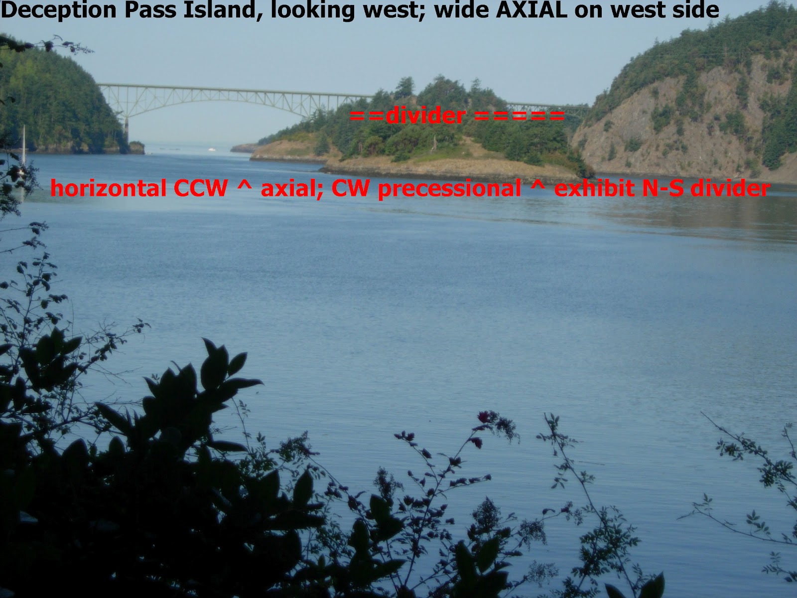
The repetitive FEATURES are shown, and we will EXHIBIT these for the HIKE-ABLE ones on Whidbey Island:
1. A TRIPLE ARC occurs, with the central ROTATION opposite to those surrounding it;
2.A WASATCH LINE (in WHITE) separates the two OPPOSITELY-ROTATING ARCS (these are the Colorado Plateau and the TRANSITION ZONE of about 40 km in Southern Utah);
3. WAVES WITHIN WAVES for the larger features; and,
4. Solubitity changes at the intersections (iron, potassium increase)- indicating THERMAL RISES.

Whenever there is a EARTH TIDAL SHIFT
ACROSS QUADRANT boundaries, the TIDAL RATES CHANGE SIGNIFICANTLY:
The case investigated is that of the Hoypus
Point in the Deception Pass-Saratoga shipping channel. This waterway exhibits a
DEVILS MOUNTAIN FAULT SPLAY that makes a significant turn (INFLECTION) at
Hoypus Point. This inflection represents the TIME WHEN the EARTH changed its ORBITAL
distance from the SUN SIGNIFICANTLY! When the NEW MOON and the SUN combine their
GRAVITATIONAL ATTRACTION for the earth (requiring kilo-years of repetitive actions),
the earth is pulled toward the sun to accelerate, compress, and decrease its
diameter slightly.


The combination of all this is such as to
decrease the EARTH TIDE FRICTION RATE, as the EARTH INCREASES ITS ROTATION RATE
SLIGHTLY- OFFSETTING NORMAL LUNAR FRICTION and creating thrusting within the
crust. Below is my version of a SINKING BASIN, SUBJECT MOSTLY to EXPANSION and NORMAL FAULTING. COMPRESSION WOULD EXHIBIT the opposite- CONTRACTION and THRUSTING:


This is exhibited by the HOYPUS POINT
TRANSITION ZONE, where two oppositely-rotating ARCUATE FEATURES are divided
along a WASATCH LINE-DIVIDER (see the transition OFFSHORE HOYPUS POINT):


Further south, the PENN COVE FEATURE is near the
center of another CRUSTAL BLOCK, which exhibits 4 QUADRANTS with varying TIDAL
RATES. THESE ARE SMALL for the NE corner quadrant, MID-MAGNITUDE for the NW
corner, and LARGE for the SW quadrant:

After accelerating and then shortening the
distance to the sun, the earth RECOVERS and subsequently slows, increasing its
distance from the sun, and expands (diameter increases slightly, with
EXTENSION-NORMAL FAULTING). This is normal for the EARTH-MOON DANCE monthly about their CENTER of MASS,
but in this case there is UNUSUAL ELLIPTICAL EXPANSION due to some
as-yet-determined GRAVITATIONAL EVENT (which probably is associated with the 2
m.y. ICE AGE, where the cold is produced by the greater distance from the sun).
It is likely that some large SOLAR SYSTEM BODY attracted the earth from its usual path (such as a large asteroid or
comet, but nevertheless in the SOLAR SYSTEM GRAVITATIONAL ARRANGEMENT) .
Although the LOXODROME MATHEMATICAL THEOREM
predicts a N-S LONGITUDINAL ORIENTATION, there is something which diverts this
expectation, and it is a few degrees off N-S. Notice that Double Bluff divider is oriented N250W- which is the same orientation as the last ICE FLOW at Penn Cove and for the orientation of GLACIAL STRIATIONS on Goose Rock.This probably will reveal
new information about crustal-tidal dynamics, and it will require additional
work to determine it. NEXT, I will detemine how a SPIT (arcuate, located at an INFLECTION, and determined by SHIFT ACROSS QUADRANTS) is GRAVITATIONALLY-LATERALLY SHOVED away from the shoreline.
STAY TUNED!
No comments:
Post a Comment