SUMMARY:
The LaGrange
Equilateral TRIANGLE is a Useful Math Tool for Dating and CYCLE Determination
of Hot Springs and VOLCANOS! It works BEST for Oceanic TRANSFORM FAULTS, which combine with Sun's CYCLES of 7.2 degree SEGMENTS to SHEAR along these LINEARS! All that required is the LOCATION
of a HEAT emission Latitude and Longitude, the Distance to a VISIBLE LINEAR
(such as a Harmonic of 1.111111 meters), and the confirmation of the Straight-line
Portion of a Scarp, Anticline, Valley, or other visually-seen LINEAR. Pah Tempe
and Veyo hot springs are shown to “fit” these requirements.

2. 60 degree CORNER ANGLES, and, MOST EASILY SEEN and Measured,
3. the Hurricane fault Hf LINEAR PORTION of 100 meters. These fit the requirements for the LaGrange TRIANGLE- which has HEAT CREATION at POINT #1, according to the MATH of LaGrange! HEAT is that of FRICTION, at a fixed Location, but "Jerking"!
ERRORS arise from the Trigonometric DIVISOR, which can be CALCULATED PRECISELY! I have used my Contrived Trig CIRCLE, shown below:

The PAH TEMPE CASE indicates that the TIME INTERVAL is 3.6 k.y. (allowing for small Trigonometric errors, from the above DIAGRAM), and this has HARMONICS! EXPECTED is the 1/1000th Harmonic, which is a 3.6 year CYCLE!
The BINARY PROGRESSION predicts that POWERS of 2, such as 4, 8, 16 and 32 form CYCLES, and this is borne out by 4 SEASONS, WEATHER in 4 year cycles, and Major EVENTS: 256 m.y. PTr Orogeny, 64 KT Extinction, 16 m.y. Columbia Flood Basalts! Both 2, 3, and 4 divide EVENLY into 3.6 (1.8, 1.2, and .9 ratios), so that these ALTERNATES must be CONSIDERED!
LaGrange Point #1 has a STABLE GEOGRAPHIC LOCATION, with HEAT from Friction of the MOVING SURROUNDINGS. The direction of EARTH TIDAL MOVEMENT is unknown, and must be found from a LINEAR SCARP, RIVER Valley, or Anticline. Knowing the Point #1 LOCATION, a SEARCH must be made in all DIRECTIONS to find the LINEAR which fits the REQUIREMENT for a MULTIPLE of the 1.1111 km DISTANCE! Finding this LINEAR, "fixes" the TIME INTERVAL, according to the chosen EARTH TIDAL RATE.
Find whether there is a YOUNGER TRIANGLE (shorter SIDES) shown in the Virgin Canyon. There should be something younger, since the TEMPERATURE remains Hot at 100F:

NOTICE that the TRIANGLE, as seen by SHEAR LINES in the Canyon is now shown in the MIDDLE of the canyon. Blue TRIANGLE is the Younger one.. Further, it ORIENTS in a Significantly DIFFERENT DIRECTION, from the RED, which is the LARGER TRIANGLE! How can this be EXPLAINED?
LOCATION above is further into the Canyon, from the present Hf! This means that the FAULT has advanced to the WEST, and that the TELL-TALE MARKS have remained.
The TIME INTERVAL portrayed is 1410 years- about HALF of the previous TIME INTERVAL CALCULATION!
"Shouldn't the Calculation yield a THIRD of the 3600 years?"
ANSWER is that the TRIGONOMETRIC TIDAL RATE is smaller as the ORIENTATION proceeds to the NW! Colorado Plateau has ROTATED CCW with Time Passage! Looking MORE CLOSELY:

These REASONABLE RESULTS may have small ERRORS, but they exemplify that SIMPLE MOVEMENT RATES may be found from DATA found on Google Earth! The LARGEST 51.6 mm/yr RATE less the 27.72 NORMAL Basin rate yields a NET RATE of 23.88 (Generalized, and a Basin Rate is UNKNOWN)! Veyo HOT SPRINGS RATE found below, (Scroll down) is 24.33 mm/yr., and this is as ACCURATE as possible with the FEW CASES Calculated!
Another CASE which can be HIKED and observed CLOSEUP is that of the Veyo Volcano, near St. George, UT, which has a NEARBY HOT SPRING:


Above wil be RE-ANALYZED, to INCORPORATE New Findings:


ENLARGED:

Above has the LARGER TRIANGLE at 9.1257 k.y. ROTATING CCW toward the smaller. This indicates RISING, which is CORRECT for HEAT GENERATION!

TIME INTERVAL is 9.1257- 4 k.y.= 5.1257 k.y., and this alllows CALCULATION of the NET MOVEMENT RATE:
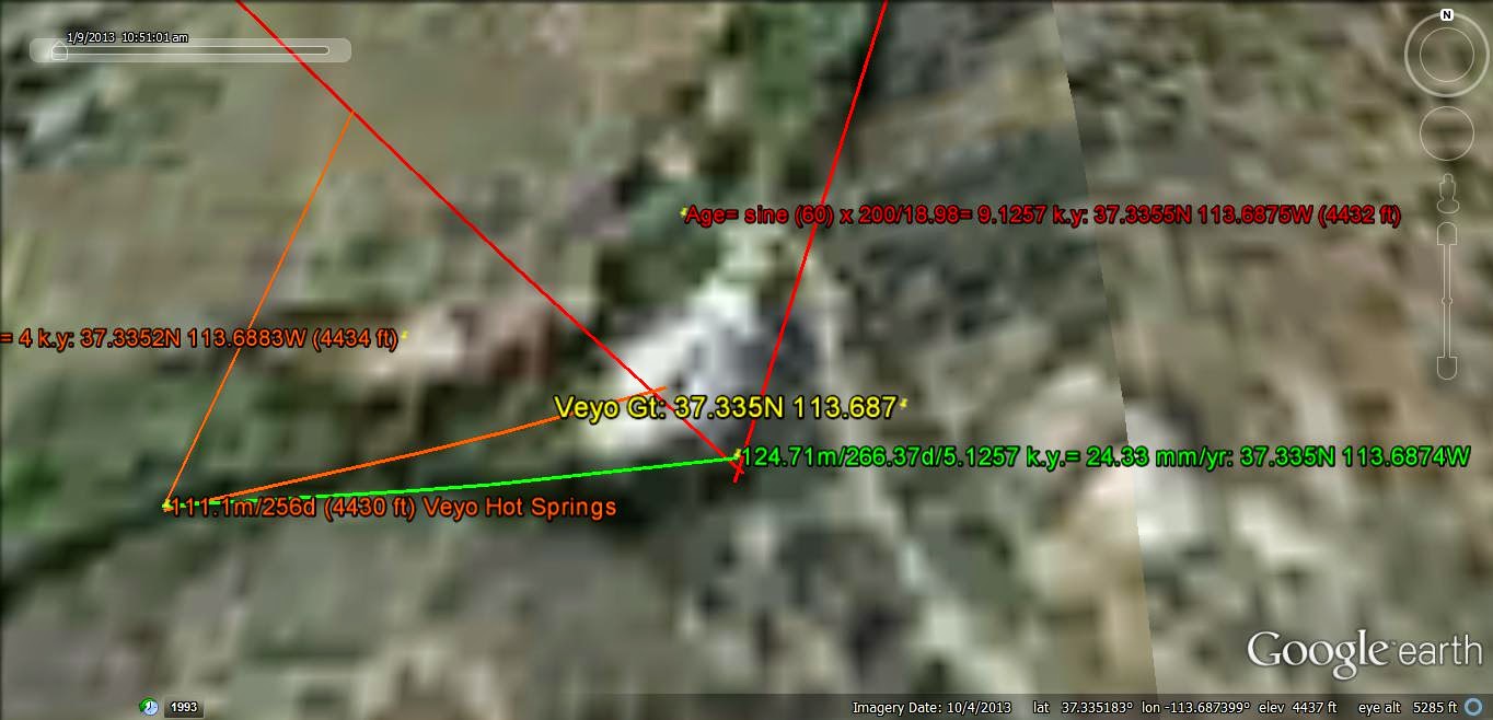
RATE of 24.33 mm/yr is REASONABLE, for a WESTWARD MOVEMENT (WNW yields 24.1 mm/yr, according to the TIDAL DIAGRAM shown earlier!)
Veyo is within the Basin and Range, away from Hf and the Colorado Plateau, CP. Its MOVEMENT RATE is that of the SLOWER MOVING SIDE of Hf (to the West)!
What is the VALUE of all this? Can we expect "CRACKING" in the slabs of the nearby HOUSES?
Hf is moving to the WEST! this is a COMPRESSION, NOT an extension! 24.33 millimeters is about an INCH YEARLY. Expect the Hf CLIFFS to move WESTWARD by this amount yearly- yielding ROCKFALL and TERRACES formed by the 3 "JERKS"!
From Sullivan Knoll:

NOTE: the LaGrange EQUILATERAL TRIANGLE has allowed an ANALYSIS of the SMALLEST POLYGON, the TRIANGLE, to MEASURE and MATHEMATIZE the LINEARS shown on Google Earth. I knew that ARCS were composed of many Head-to-Tail linears, and NOW we can more SIMPLY place them in a UNDERSTANDABLE RELATIONSHIP!
DIGITAL PHOTO, showing the TRIANGLULAR RELATION of an UPLIFT:

TERRACES viewed from Sullivan Knoll:

ENLARGED:

Above DIGITAL PHOTO is several years OLD! Note that assumptions of TIDAL RATE were INACCURATE, and that .16 km (160 meters, or 160,000 mm) SEPARATION/25 mm per year. yields 6400 years! This is near that found from the TRIANGULAR CALCULATION, and is the INTERVAL TIME between "JERKS"!
Other INFORMATION is CORRECT, and this PHOTO should be used for discerning the "JERKS" as compared to a creeping movement!

Hf is shown above in a DIGITAL PHOTO, and the 3600 year JERK is shown below (drop from the SKYLINE, of the BASALT to a lower elevation- Lower ELEVATION):
 -
-
Hf Gouge (indicated by COLOR CHANGE):

WIDE VIEW, lookng EASTWARD:

Hf SLICKENSIDES at Hiway 9, Laverkin, 3 km to the NE:

 Shiny Slicks, ILLUSTRATING that there is CREEPING, or slow movement (NOT "JERKING") just 3 km DISTANT from the Virgin River
VIRGIN RIVER has made the "DIFFERENCE between JERKING and Creeping"! The MAIN FACTOR is the CW ROTATION at Laverkin, shown by the HOGBACK, and the CCW Rotation of the COLORADO PLATEAU, CP!

UPPER Right shows the DISPLACEMENT caused by a "JERK" (Normal Fault))
This RATE may be used to solve the Hf Pah Tempe NET RATE!

NOTICE above, that the "JERKS" (Separate TERRACES) compare with the fading or eroding FRACTURES shown on the NORTH SIDE of the Vigin Canyon. Hf is formed by "JERKS" separated by indicated TIME INTERVALS! This presages VIOLENT EARTHQUAKES at 6400 year INTERVALS, and less shaking at 3600 year INTERVALS!

BLUE LINEAR Triangle denotes the smaller TIME INTERVAL, and Red the larger! The FRACTURES ALIGN with one SIDE or POINT of the TRIANGLES! VIOLENT "JERKS" CYCLES are more closely-SPACED than expected.
"When will the NEXT VIOLENT QUAKE OCCUR?"
ALL activity depends upon the HILDA ASTEROIDS; an INCREASE of Mass in the Asteroid-Jupiter TRIANGLE will produce this "QUAKING"!
Since ASTEROIDS are the "TRIM TABS" of the SOLAR SYSTEM- reacting to OTHER EVENTS (such as FEEDBACK from Earth), this MAY BE PREDICTABLE!
Let's COMPARE with the FISSURES, 5 km to the NE, which is a VERTICAL PRESENTATION

Above FISSURES produce NO HEAT, since they are exhibited VERTICALLY, and the LaGrange STABILITY creates FRICTION LATERALLY!

Fissures CALCULATIONS yield 10 k.y. below:

ALL this is NOT to infer that Hf has this AGE; this small SEGMENT is YOUNG!
AGE of Hf is shown by the TOTAL TRACE:

NORTH LATITUDE of Hf is shown above, with South Latitude below:

TOTAL LENGTH of 820.3971 km yields 46.9335 m.y. or 50.517, if MOVING SOUTHWARD!
CONJECTURE:
1. Hilda ASTEROIDS produce HEAT, where
2. MASS of all ASTEROIDS in this STABLE ZONE determines the EXTENT on Earth!
3. ASTEROIDS act as "TRIM TABS", where the GRAVITATIONAL RE-ARRANGEMENTS react to Changes on Earth!
4. TOTAL MASS of Asteroids in the "Hilda" ZONE determines the HEAT PRODUCTION on Earth, and this should occur in a REGULAR CYCLE;
5. ASTEROID YEAR is irregular, the YEAR for Jupiter is 11.86 Earth Years, which NORMALLY would be GREATER than normal Asteroids' years;
6. ASTEROIDS' ORBITS are IRREGULAR, but average 6 Earth Years! This will determine the CYCLE of THERMAL EVENTS, acknowledging that the "Hilda" category may LINGER in a PERIOID Not yet determined!
7. Relate this CYCLE to the 3600 year "JERK" of the Hurricane Fault, and this indicates that a LONG RANGE COMET or Asteroid's CYCLE is involves!
A SEARCH of Comets' PERIODS will be made.
HALLEY'S COMET has a PERIOD OF 76 years, and the Chinese have reported OTHERS of LONGER CYCLES. Best to glean from GOOGLE Earth!
Jupiter's MOONS may interact with Earth, SIMILARLY to Earth's MOON, where the influence is N-S along MERIDIANS.
CARPO has 58.56 degrees INCLINATION, yielding 111.111 x = 6506.67, with 1.667% from 6400 years, DEVIATION, EQUATING Time with DISTANCE, as was shown by Milankovitch!
Himalia has 30.486 degrees Inclination yielding 3387.33, with 5.91% DEVIATION!
Literature has considerable VARIATION with MEASURED INCLINATIONS, and I am NOT SURE which is the SOURCE of the Variation (Mine or theirs)?
FACTOR to be CHECKED: whether the Jupiter MOONS act N-S to Earth's Meridians, as does our MOON, in this CASE along the Hurricane-Wasatch Fault.
Testing, for PAMUKKALE Geothermal AREA in Turkey:

Above Gt field has a CALCULATED HIGH RATE of Movement to the SW! It may involve a LARGER TRIANGLE, since the Hot Springs (which are very ACTIVE) lie on the EASTERN BORDER of the LARGER TRIANGLE:

LARGER TRIANGLE yields a MORE LIKELY Tidal Rate: 27.265 mm/year to the SW!
The GEOLOGY of Kizildere FIELD is Literature searched to find that the TECTONICS are during the Pliocene until NOW (2400 meters DEPTH in the Menderes Massif), and I am presenting the SHALE LOG I ran in 1971:

ROCKS from CUTTINGS were METAMORPHIC, and when made into a SLURRY with distilled WATER yielded the ABOVE LOG (Patented).
Above ANALYSIS is NOT satisfying, and it is RE-PRESENTED below:

Above ANALYSIS is better, since it has an EVEN LATITUDE at the "Hotspot"!

FINALLY, a view of the Kizildere (Red Creek) AREA:

SEPARATION of Production area from 38N is 4 km, and this is CLOSE ENOUGH for the Main REQUIREMENTS:
1.Even Latitude;
2. 16,000/88.8888= 180 RATIO;
3. TRIANGLE has 3 SIDES of 88.888km;
4. AGE is 5.554 m.y, close to the Harmonic of 111.111 km (Milankovitch's Time equivalent to Distance);
and,
5. 180 ratio MAY Refer to RETROGRADE BEHAVIOR (Uranus)!
NOTE that Uranus' INCLINATION ANGLE= .773, and this is CLOSE to the Harmonic of 111.111, where RATIO = 111.111/.7729813= 143.7436. as COMPARED ro 177.4 degrees (ROLLING along its ORBITAL OATH)!
There is DIFFICULTY finding the LINEARS in this MOUNTAINOUS Region! Try another CASE in the Atlantic Ocean, the CAPE VERDE ACTIVE VOLCANIC FOGO:

AGE of Cape Verde from the LaGrange MATH= 31.2419 m.y. , which is in the Oligoocene. Literature rerports .VARIOUS AGES from 22 to 180 m.y. since they have LITTLE INFORMATION to use, except Basements and the MISLEADING PLATE THEORY (leading in the WRONG DIRECTION)! Further, the MANTLE PLUMES have NOTHING to do with Gravitational UPLIFT!
FOGO on the big Island has erupted RECENTLY! This gives INSIGHT into the MECHANISM! Increasing MASS in the "Hilda" ASTEROID CATEGORY will be investigated!

Mt. Ararat in Turkey is an ACTIVE VOLCANO:

BASELINES cannot be easily seen, compared to those in the Ocean (TRANSFORMS)!

Literature reports an AGE = Quatternary, with the LATEST at 1840 AD. Earlier EPISODES are in the Oligiocene, with Mt. Ararat developing LAST!
Below is a PHOTO closeup:

BEST to make AGE CALCULATIONS for Volcanos associated with Oceanic TRANSFORMS!
CLOSEUP:

MENDOCINO TRANSFORM Development:

RATE of Movement= 19.04 mm/yr, which is REASONABLE for the NORTH SHIFT (17.48 is the TRIG Rate, with 8% ERR)! More PRECISION is necessaty!
DETAILS show the DISTURBED AREA, which will be INVESTIGATED:

ANALYZING:

RATE of earth tidal MOVEMENT IS 25.824 mm/yr, which COMPARED to the expected Trig's 20.48 has a 26% deviation! This is EXCESSIVE, but may be CORRECT at this ANOMALY! There is FAST ROTATION, at the PERIPHERY of Large CIRCULAR MOVEMENTS (such as the HI-Emperor Seamount Chain, yielding 86 mm/year)!
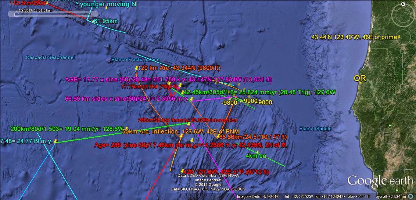
Partial FIGURE 8 shown below indicates REVERSAL, or SINKING:

DEPTHS are shown for the RIDGES and SINKS. Saddles and Basins are sinking!
HOFSTEDTER TRIANGLES:
Further ANALYSIS of the OFFSHORE MOVEMENT is provided by the Relation of 2 Hofstedter TRIANGLES- one smaller (younger) than the other:

Hofstedter MATH has the LARGER enclosing the smaller TRIANGLE! This is NOT the case above, but this is an EXPERIMENTAL TRIAL! Expected is the creation of MOVEMENT of the CENTER toward the Younger's position, yielding the formation of Uplifting, Heat, or Direction! This will be treated further:
, PROGRESSION to the NORTH is shown for YOUNGER TRANSFORMS:

Smaller TRIANGLE lies within the LARGER, and the TRANSFORMS agree! TIME INTERVAL is near 4 m.y. SIMULTANEOUS with the formation of a PARTIAL FIGURE 8.
There is EXCESSIVE SUBJECTIVITY with above ANALUSES, and Hofstadter MATH will be ABANDONED!
STRING LAKES in WA State (Shannon) are ANALYZED below:

UNINTERRUPTED Section of Lake is 5 km in LENGTH; find the Volcano to the WEST, matching this TRIANGLE SIDE, 3rd TRIAL yields 718.693 k.y. (Pleistocene) for the TWIN SISTERS Peaks:

LARGE Picture of TRIANGLE with 20 km SIDES:

MOVEMENT RATE to the North at 27 mm/yr is REASONABLE! There is a ROTATION to the north east, CW!
MEASURING from 3 SISTERS Peaks, the TRACK of the EARTH TIDES may be followed! It has PROCEEDED SOUTHWARD (from OLDEST Three Sisters PEAK) then REVERSED to a mostly NORTHWARD PATH (see the Green to Yellow LINES)!

Above PATH suggets that the VOLCANIC SEQUENCE has a mostly N-S PATH, but REVERSES from some LIBRATION of a Moon (NOT NECESSARILY our Moon, but from one of Jupiter's)!
To be CONTINUED!
No comments:
Post a Comment