
SUMMARY:
Mima MOUNDS are FORE-RUNNERS of Conical Hills and Mountains; they prevent two CW-rotating Crustal ARCS (valleys or waterways) from interfering with each other, which would otherwise develop HEAT of FRICTION (as they scrape against adjoining edges). Vulcanism, and Hot Springs would develop (this forms a buffer zone between the 2 RISING FEATURES that they separate). They exist adjacent to two actively-shearing features, such as 2 Milankovitch rotations in the Crust of the Earth (or with HARMONICS for smaller scale features). They pin-point ANOMALIES, such as Double Bluff, Whidbey Island and the Willamette, Umpqua Rivers ERRATIC paths (east turn from previous N-S traces). They locate regions or localities which exhibit inexplicable ANOMALIES!
Mima MOUNDS are a product of the MECHANICAL Movements of the Earth; they result from the Mathematical DERIVITIVES of the Distance Vectors (which entails direction, or ANGULAR CHANGE): d(S= distance)/dt= VELOCITY, V; dV/dt= Acceleration, A; dA/dt= Jerk, J; dJ/dt = Chatter, C, which is the Sinuosoidal movement producing the Mounds. These can be visualized for your auto, where V is the speed, A occurs upon changing the speed, J happens with sudden acceleration, as with sudden push down on the gas pedal, and C is the UNEVEN application of pressure, causing back and forth movement of your head for an VARYING uneven pedal pressure.
These pertain to LINEAR Equations, and for a 3 Dimensional Earth, may only be APPROXIMATED! Consequently, I will post estimated ERROR, which is small for a LOCAL area or distance. However, REGIONS and Continents yield increasing errors, where even the measured ANGLES are variable from 2 different DIRECTIONS! Consequently, the Presentation of Mima Mounds is fairly CORRECT, for a Golf Course, but has large ERROR for Mounds which occur as Islands in an ARCHIPELAGO!
WHENEVER there is Lateral Compression, Sinusoidally, Mima Mounds occur (sometimes called Pimple Mounds), Accompanying REDUCED TIDAL LATERAL MOVEMENT- from Slight slowing of EARTH'S ORBIT and SIDE-WAYS SHIFT, for SAN JUAN ISLANDS, WA.
NOTE: They are RISES, between SINKS or waterways:


Above is a preliminary calculation of MOVEMENT RATE, and below is the ELLIPTICAL exhibit (ring of Mounds) for the set of Lateral, westward THRUSTS:
SILTATION (lateral disturbance) at Lopez Island:

Mt.Constitution, being the TALLEST, is the oldest by this height measure:


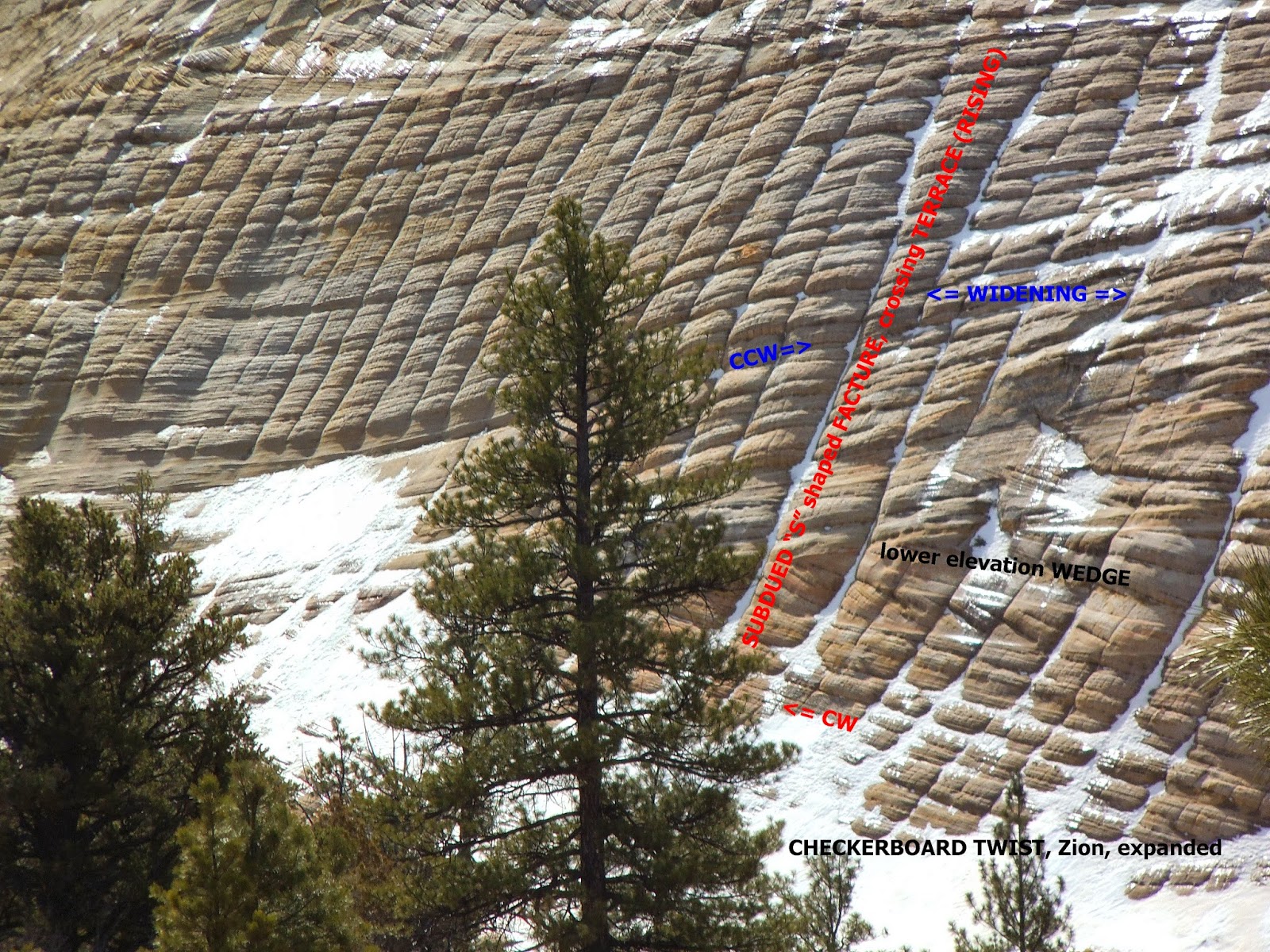
View from Mt. Constitution shows the HARDENING of the rocks, due to Compression and TWIST:

San Juan Islands result from THRUSTS from the east, which are post-Mesozoic for these Cambrian to Cretaceous Rocks. This allows an appraisal of movements occurring in smaller scale Mima Mounds. The SINUSOIDALLY-UNDULATING Mounds (similar to water waves, oscillating laterally, BUT resulting in miniscule water TRANSFER) appear to exhibit little DISTORTION of the sedimentary column. This is shown below for a mound which was used for road gravel:


Above is the PATTERN for those at Little Rock, WA, State Park, and below is the UNEDITED view of the Coupeville, WA gravel pit:

The INVERSE of Mima Mounds is the KETTLE, or a Circular SINK, shown for Crescent Lake:

South of the Lake is Sol Duc Gt, Hot Springs:

What is demonstrated is that Mounds are the result of LATERAL MOVEMENTS (similar to thrustimg). which cause the SEDIMENTARY COLUMN to RISE and SINK (fall), with little distortion of the beds. With TIME, the HEIGHT increases, as does the DIAMETER; this yields a SINUSOIDAL Wave on the Surface of the ground, developing a Mountain or CONE later!
Return to the Mid-Range PATTERN of Mounds.


OBLIQUE:


THEY OCCUR LATERALLY WITH ELLIPTICAL FEATURES, SUCH AS THE PINE VALLEY INTRUSION (AN ELLIPSE ITSELF, WHICH HAS SMALLER ELLIPSES SURROUNDING IT):


THE MOUNDS I HAVE FOUND FROM 10 CASES STUDIED ARE INFLUENCED by the INTERFERENCE of AXIAL (40 k.y. or their HARMONICS) AND
PRECESSIONAL (21.5-25.5 k.y.) tilted ARCS. This is shown in ABOVE DIGITAL PHOTO OF MOUNDS SURROUNDING THE PINE VALLEY LACCOLITH-INTRUSION.
THEY SURROUND THE SAHARA DESERT, WITH MOUNTAINS "ALL AROUND":

BELOW IS A CASE I AM WORKING ON AT PRESENT, AND WHICH ANYONE CAN ACCOMPANY, SINCE it is EASY WALKING, at the AZ BORDER, IN FORT PIERCE WASH, WHERE THE FOLDING CAN BE SEEN IN THE CLIFFS TO THE NORTH, AND WHERE THE MOUNDS ARE SOME 10 METERS IN HEIGHT. I WILL SEARCH AT THE BASE TO DETERMINE IF THERE IS ANY UPLIFT, BUT I EXPECT THAT THE SEDIMENTS WERE SHOVED LATERALLY (AT THE EXPENSE OF SURROUNDING MATERIAL:

BELOW ARE MOUNDS YOU HAVE SKIRTED EACH TIME YOU HAVE USED 1-15 NEAR HURRICANE CITY, UT. a UNIVERSAL FEATURE WITH THE EARTH, occurring in


 ELLIPTICAL PATTERNS, EACH TIME THERE IS "CHATTER" from Sinuosoidal POLAR WOBBLE, which offsets NORMAL WESTERN EARTH TIDES. THEY SLOW THE EARTH IN ITS ROTATION (SLIGHTLY) AND CAUSE THE EARTH TIDES to be SOMEWHAT LESS THAN 20km/m.y., or mm/yr. NEAR SUN'S EARTH TIDES OF 10 km/m.y.
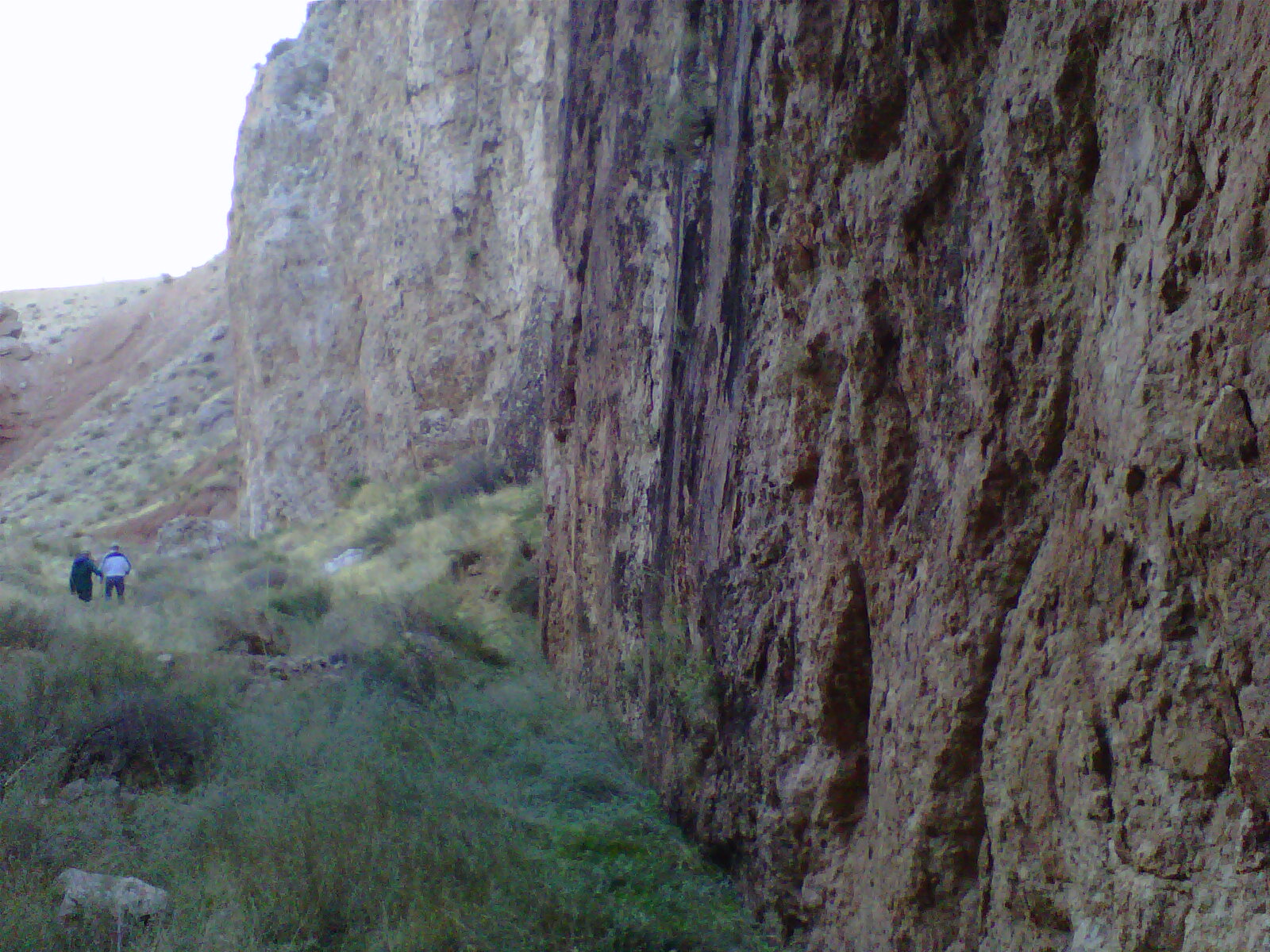

FINALLY, THEY SURROUND THE NORTH AMERICAN CONTINENT WITH EXTRUSIONS, IN AN ELLIPTICAL (with GAPS) ARRANGEMENT OF VOLCANIC ISLAND-MOUNDS (with depths SUFFICIENT TO EXTRUDE NORMALLY-HEATED BASALT FROM THE TOP OF THE MANTLE). This EMPHASIZES THAT THE ALTERNATION OF bottoms to MOUND Tops RESULT FROM A WAVE PHENOMENON (AS WITH A NORMAL WATER WAVE, WHICH MOVES MASS UP AND DOWN AS THE WAVE "RIPPLES" LATERALLY).

The Amazon basin in South America is a LARGER EXAMPLE:

MIMA-TYPE MOUNDS, resulting from LATERAL MOVEMENT OF THE CRUST. WHENEVER THIS OCCURS, THE NORMAL EARTH TIDE OF 20 mm/yr. IS REDUCED AND MUST BE MEASURED LOCALLY. SOLAR TIDES, NOT INCLUDING THE LUNAR TIDES, ARE NEAR 10mm/year. compared to the NORMAL Crustal Movement of EARTH AT 20 km/m.y. EarthTides. A distance REFERENCE fot these can be found for N-S distances is 40,000 km CIRCUMFERENCE OF THE EARTH/360 degrees= 111.111km/degree. CHATTER CAN BE IDENTIFIED WHENEVER THERE OCCUR ELLIPTICAL ARRANGEMENTS of SEAMOUNTS, ISLANDS, REBOUND from LATERAL Compression, alternating with Extension!
When Mima Mounds are LOCATED, what is their IMPORTANCE, in terms of EARTH SCIENCE?
The location of Holmes Harbor Golf Mounds lies between 2 SINKS, indicating that the Mound ELLIPSE absorbs the SHOCK between the two, which would create HEAT, were the ellipse not present. Two CW rotating features are separated by one CCW rotation, and the result puts the ENERGY into raising the Mounds, rather than geothermal heat! We'll see how this conclusion "FITS" other cases, e.g. Double Bluff, to the south of the Freeland larger Mounds:
This fits, with the Caveat that I have used 69 k.y. for the Double Bluff AGE. TIME INTERVAL should be less, making the 44.5 mm/yr movement to the NNE too small!
Let's see whether this SERINDIPITY is found at the Eugene, OR mounds:

Mounds are in 45 degree arrangements, with a ELLIPTICAL pattern, above.

Double Bluff, below, and the Freeland Fish Road Mounds, above, indicate that the Mounds started RISING at 13.43 k.y. (AGE, after last ICE movement), and that they have resulted from a NNE-ward MOVEMENT! This is "against the grain" and could indicate that the MOUNDS absorbed the Lateral Gravitational MOVEMENT, resulting in SINUSOIDAL "HUMPING" or buckling, rather than shear.

Direction of MOVEMENT for thrusting on Whidbey is shown for a SCARP south of Hancock Lake:


Below is a Major CONE, at Juneau, AK, exemplifying the ENLARGEMENT of the mound, both Vertically and Laterally:

Below is a GOOGLE Earth view of Juneau:


METAMORPHOSED scarp, at frontal street, Juneau:

CHECKING against the Original Mima Mounds State Park- the Namesake:

LARGER AREA:

LARGER, yet:

Finally, the AGE of the enclosing POLYGON, 2.46 m.y:

Checking the Pacific DISPLAY:

The Mounds, above, are related to the enlargement of the Puget Sound, SOUTHWARD, as shown by the east LIMB of the 10 sided POLYGON.
This suggests that the CHATTER, shown by the mounds, is a set of complex rises between waterways (in this case, Puget Sound and the Columbia River):

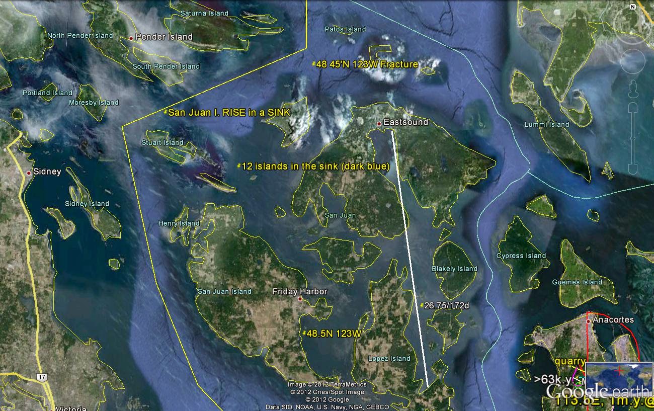
Next, I will focus on the Deception Pass, Whidbey Island, where both RISES (Islands) and SINKS (Cornet Bay) portray the CONTRAST:

DETAIL:

CORRECTED LARGER View:

DIRECTION (westward) is determined by the Protrusion of the ARCS, and this is important for determination of the Divisor 24.1, which is between 20.48 and 27.72 degrees, by Trigonometry for NW to Westward. Time Interval is found by Distance TRAVERSED/Rate of Tidal MOVEMENT. Expect errors of 2-3%, because of EXTRAPOLATION of rates between known Trig ANGLES!
I do not find any indications of HEAT, and one should traverse the SCARP to find temperature RISE at open fractures.
What is the PRATICAL VALUE of all this?
1. Mounds are EXCELLENT for the Gardener; they have continually-opening microcracks, and VEGETATION finds these for Capillary Water. The mounds always grow flowers better than surrounding low spots! Camas love them, as does the Golden Paintbrush:


2. Finding MOUNDS means finding water; streams ORIGINATE nearby, and the More Sheer will develop Hot Springs;

Green Springs, Washington City, UT, above, and Sol Duc Hot Springs, Olympic National Park, WA, below:

3. Golf course afficianados will love these mounds; they make excellent spots for the Developer;

4. Mounds solve the Metamorphic problem; they form Metamorphosed Mountains at shallow depth, with the CONTINUAL TWIST;

Juneau City above, and Mt. Roberts- a Metamorphic feature, below:

Larger view:

An ANALEMMA is composed of 2 or more mounds, which can be seen to be separated by a SLICE, or divider:

Mt. St. Elias, at AK, Canada BORDER:

and,
5. They form TERRACES, as the twist rotates the Mound CCW (Rising), and hikers can realize that the narrowing TRAIL will soon DEAD-END!
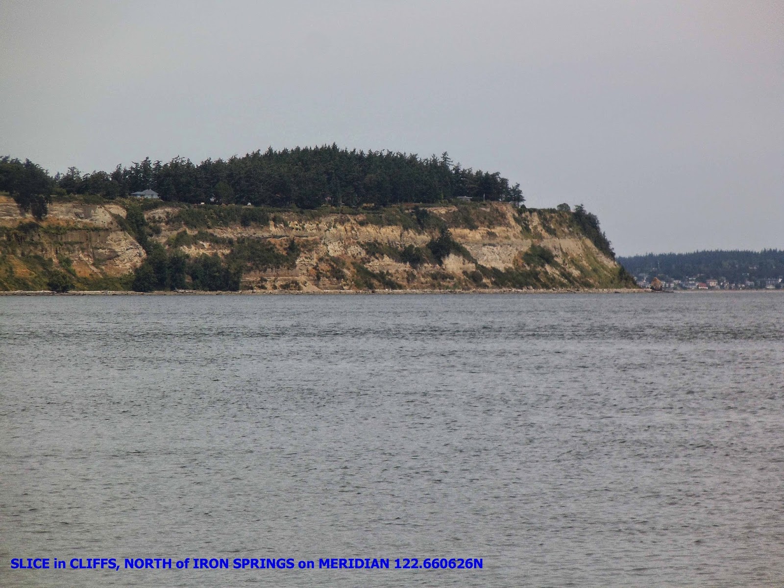
Below is an INVESTIGATION into Iron Springs, Penn Cove, Whidbey Island, WA: there is only a slight increase in Temperature, but ENOUGH to increase the Iron SOLUBILITY! When the water emerges, its T drops, along with Pressure, and the Fe++ changes to Fe+++, which is less soluble. This produces an EXOTIC display, with a clear indication that the spring emerges along a N-S Meridian, and is due to expansion of the ARCUATE Bay (creating a HOLE along a SLICE, which widens with time):

LARGER VIEW, with COORDINATES:

Above the EXOTIC springs occurs a HOLE:

Across the Penn Cove, the MERIDIAN exhibits a SLICE oriented N-S, but slanted with an angle of 30 degrees (Pallas has 34 degrees Inclination above the Ecliptic Plane):
SNAKELUM Point is named for the last known Tribal Chief, for the existing Clan:

FROZEN SPRING
Something stopped me by a mountain stream-
Something which caught my eye;
A glistening fantasy of bluish light
Shimmered, as water slowly trickled by.
High on a hillside, fixing my stare,
An infinity of color came through-
A trickling spring, arrested by fate,
Broadcast its indigo hue.
Woven in grass by clever design-
Its icicles showing their smile-
The fragile brooklet waited that day,
For springtime to be in style.
How curious that water crystals should stop my trek
And accelerate my heartbeat anew,
While a million tiny pulses are locked in mid-air
By winter’s frigid curfew
Harold L. Overton
No comments:
Post a Comment