One degree of Latitude is EQUIVALENT to 111.111km (from 40,000 km)/360 degree CIRCLE); this is the DISTANCE necessary to TRAVERSE from a N-S drainage at the Green, Colorado Junction, to a POINT of INSTABILITY on the Earth's surface. For the 36N Latitude, the drainage then proceeds SW-erly, and CONTINUES until reaching the 35 degree Latitude- where it then returns to N-S DRAINAGE!

Above 37N Latitude is the start of the CONVERSION of the Colorado River from a N-S trend with the Green, to a DIAGONAL TREND until reaching 36N, where it REVERTS to a N-S trend going towards Mexico!

The Colorado River TRANSITIONS from a DIAGONAL to a N-S FEATURE south of Lake Mead, after which it is DOMINATED by Lunar TIDES!

Let's see how the Columbia River, flowing WEST after its SOUTHERLY DRAINAGE at the Idaho border, fits:

The CHANGE of LATITUDE is .3 degrees, EQUIVALENT to 33.33 km, and the calculated TIME INTERVAL is 2 m.y. for this TRAVERSE from N-S to W-E to occur. This is much FASTER than the Colorado and Green TRANSIT requiring 2 degrees of Latitude to make the shift to the N-S path at the CA Border, Lake Mead location (from the Green-Colorado JUNCTION), STRONGLY suggesting that Latitude is the Prime FACTOR!
The Columbia traverses from N-S to E-W according to the Latitude EQUATION:
(90- 46.92687)/46+= .91797= 1/1.0894, which is the ap/perihelion RATIO for Jupiter. This LARGEST of all Planets (2.5 x mass of the rest) is therefore RESPONSIBLE for the 16 m.y. Columbia FLOOD BASALTS, which occur nearby! This SIMULTANEOUSLY occurred witht the INITIATION of the Grand canyon "CHATTER", and we must inquire why the shift occurred 3 times as fast! INTERVAL TIME may be identical with AGE, but age is always equal to or greater than INTERVAL Time. 16 m.y. is the AGE of the basalts, but their Placement occurred in a SHORTER TIME INTERVAL!

There is the usual 1 degree Latitude SPREAD, CONFIRMING the use of the UNIT 1 in the Equation: (90 -45)/45= 1. Now the QUESTION arises: "Is the APPROPRIATE DIAGRAM the one using (60- x)/x= INDEX, or is it (72-2)/2= 35", in which event, the CASES may pertain to a MORE GENERAL ANALYSIS of many Solar masses, including the Prime SUSPECT Venus!

There are several POSSIBILITIES for DIAGONAL EQUATIONS. We will check for those within the Latitude RANGE of interest. First, they must FIT the 360 degree circle, with an EVEN MULTIPLE: 360/5= 72, 360/8= 45. 360/9= 40. ALL OF THESE WILL PERTAIN to the Latitudes less than 66N- which is the boundary of those belonging below the ARCTIC CIRCLE (at 66.567N):

The Grand Canyon is INITIATED at an OBVIOUS "CHATTER", which is shown at Lake Powell

Parallel canyons at the INITIATION of a TURN to the SW, I interpret as being CHATTER= d(JERK)/dt, the THIRD derivative of VELOCITY d(distance)/dt

CHATTER at Colorado River:

North to the Green River
The Green (visibly noted as the Brown)
There was an old man from AZ,
Who thought he would just take a spree;
So he cleaned out his flat,
And lost all his fat- just to make ready, you see.
With copious enthusiasm he planned;
All superfluous motions he banned-
He filled out his beard,
E’en his toenails he sheared (all for a spree on the sand).
Twould be in the year ninety-seven,
That the fling would be made to his heaven;
He would drive to the Green,
And hope to be seen, with a crew of 3 plus eleven.
He would throw all his cares to the winds,
Would abandon all his graces for sins;
He would have a great time-
Even fashion a rhyme, and much later do his amends.
The first evil omen he found
Was that raindrops were coating the ground,
And the crystal clear stream-
Being the heart of his dream- had turned up a chocolate brown.
The sand which was central to Grace,
Was nowhere to be found in that place;
But not to be daunted,
All the elements he taunted- his ashes now reside in a vase.
The boat promptly sub-marined down
Causing all the mosquitoes to drown;
But it took our ol’ man,
With his expression dead-pan, to Davy Jones’ locker in Brown.
It was never quite clear, how his spirit so dear
Remained ever so strong in that realm;
But a smile on his face, remained TRANSFIXED in all space-
When his corpse was found strapped to the Helm!
Harold L. Overton
Latitudes 36 to 37N are CRITICAL locations creating INSTABILITY of the Earth in the Western Colorado River REGION. The INTERVAL TIME of 16 m.y. makes this a Time of CHATTER in the Boundary ZONE, CHATTER= d(JERK)/dt, which is d{d(acceleration)/dt}/dt, where a= dv/dt.
The EQUATION (72- 9)/9, and (72-8)/8 may be tested in the CURLICUE of Central America, where the one degree of Latitude difference becomes important- shown in the shape of the bridge to South America:

LARGER VIEW:

The WATERWAYS of the EARTH are arranged in PATTERNS, such as the Major Lakes- which are exhibited at FRACTIONS of the 90 degree half HEMISPHERE! Examples are the LARGEST Lakes at 44 to 45N Lartitudes, and 12N for Lake Nicaragua, the Equator for Lake Victoria and the Amazon basin.

Large lakes are placed along theINTERVAL 44-45N Latitude, for Europe, part of western Asia, and North America Southern HEMISPHERE follows tthe same RULES, but there are mostly DRY SINKS, except for the Amazon and Lake Victoria at the EQUATOR:

Above VIEW exhibits lakes in the Northern Hemisphere, which are placed by Latitude FRACTIONS, according to the EQUATION: 90- 45)/45= 1, the INITIATION of Gravitational WAVES resulting in FRACTIONS which determine their arrangement: 0, 1, 2, 3, 4, 5, 6, 8, 9, 10, 12, 15, 18, 20, 24, 30, 36, 40, 45, 60, 72, and 90; these are ALL even FRACTIONS of 180 degrees (e.g. 72= 1/5 of 360).

NOTICE that the Lake is on the south side of the EQUATOR; this is the case for the Amazon also, indicating that there is more MASS in the SOUTHERN HEMISPHERE, even though there are FEWER Continents there! This occurs because of the PEAR-SHAPED Earth, with the dominant BULGE occurring in the South Seas, where Islands are RISING by Vulcanism (mainly). The Earth ATTEMPTS to OFFSET this by shoving the Australian and Antarctican land masses NORTHWARD! You can prove this for yourself by measuring the Pole to Pole distance through the South Sea Islands as COMPARED to that through the Indian Ocean on Google Earth.

Lake Nicaragua is UNUSUAL, occurring at 12N, thirtieth of 360:

Let's CHECK the Great Bear lake, which is the farthest NORTH latitude before reaching the ARCTIC CIRCLE:

The INDEX 11 is near 10.58d- the Inclination ANGLE for Ceres. Again, this is INVERTED (Reciprocal) and indicates that the DOUBLE CIRCLE or Ellipse is appropriate for this Latitude; I'll check further:

An IMPORTANT CONCLUSION is that the UNIT 1 degree of latitude, or INCLINATION ANGLE, is an indicator of the EXTENT of ANOMALOUS activity (such as the Grand Canyon), and of the TRANSITION to the "CHATTER ZONE" prior to the anomaly. It creates ANOMALOUS BEHAVIOR for those Solar Masses ORBITING at significant angles above the Ecliptic Plane, such as Pluto and ASTEROIDS, even as far north as the ARCTIC CIRCLE! These can be "SEEN" by us below (even though the Sun may NOT), so these Masses exert GRAVITATIONAL ATTRACTION on portions of the Earth's Crust below them!

Great Bear Lake is shown in relation to the Arctic Circle: 66.567N


The Olympic Peninsula-Mt. Olympus is another CRITICAL COORDINATE in relation to the INSTABILITY of the Crust, ROTATING near 40 degrees from the N-S Meridian!

Below is the "JERK" of 1.85 k.y. INTERVALS, 1000 x Jupiter's 1.88 Earth years:

CHATTER is change of JERK, d(jerk)/dt = d{d(acceleration)/dt}/dt. These will be put in USEFUL MATHEMATICAL FORM, 3 frames down:

Juan de Fuca SHIFTS 50 DEGREES at the Critical LONGITUDE of 45 degrees:

Graph it!
It appears that the BINARY NUMBERS, 1.024 BASE, occur in the Jerk INTERVAL:

Above is a LINEAR series of "Jerks" where the DERIVATIVES may be used for Mathematical INTEGRATION, and below shows the DIVERSION to the EAST:

CRITICAL COORDINATES are shown below:

RATIOS, such as 11.86 to 1.88 for Jupiter’s/Mars’ years relative to EARTH’S year, require an equation (90- 10)/10= 8, and (90-9)/9= 9. This is similar to the (72- 8)/8= 8, and (72- 9)/9= 7 (difference of 1 degree latitude), which yielded an ANOMALY at Central America: (72- 36)/36= 1, the initial start of the cycle. The total SPREAD of 2 degrees incorporates the TRANSITION ZONE- including the 1 degree of latitude PRIOR to the ANOMALOUS SPREAD, where the Grand Canyon for example occurs at an OBLIQUE ANGLE to both Latitude and Longitude. This is shown for Panama:

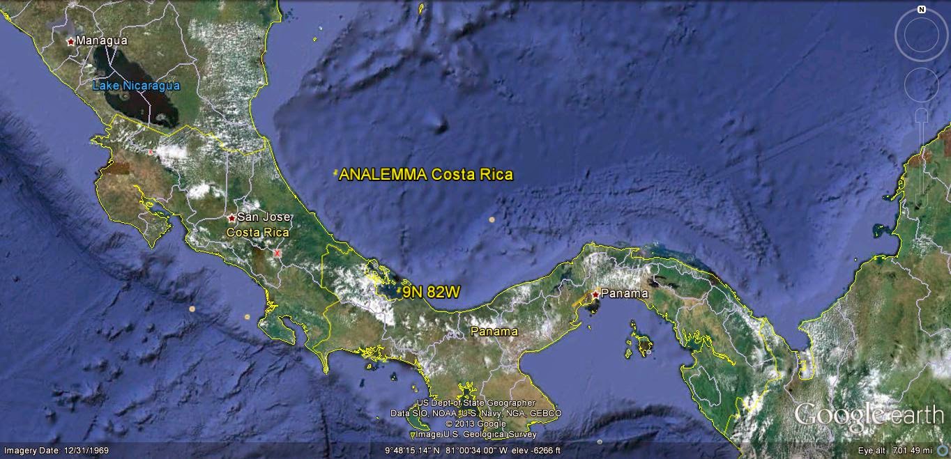
Panama, with its CRITICAL COORDINATES 8 to 9N, "fits" the EQUATIONS:
(90- 9)/9=9, and (72- 9)/9= 7, The last equation can pertain to Mercury's Inclination of its ORBITAL plane to the Ecliptic PLANE, SO THAT IT SHOULD MORE LIKELY APPLY!

DETAIL:


The Analemma, or FIGURE 8, is OMNIPRESENT on the Google Earth view of SHALLOW CRUST, and this should be used as a REFERENCE for DYNAMICS of the Earth! It will EXHIBIT a DIVIDER (usually N-S, buf IF NOT, will indicate a clue to the MATHEMATICAL EQUATION to be used for DECIPHERING the Astronomical INDEX, e.g. 5.145 degreees TILT of the Moon requires a N-S Meridian: (180- 6.145)/6.145= 28.2921074, which SUBTRACTED from Prime NATURAL Meridian at 169.9W (relative to Greenwich) yields 141.307893; checking, (180- 38.6921074)/38+= 141.307893. (180- 29.2921074)/29+= 5.145 degrees (which is a DIMENSION-LESS Ratio, comparible to degrees!):
These OCCUR on at least 10 SCALES, from CONTINENT-SIZE to the TREE ROOT below, which has followed ARCUATE SHEARING FRACTURES in the shallow SOIL:

The LARGEST forms CONTINENTS, shown below in the Continental USA and Canadan CRATONS:

The Canadian CRATON is 122 m.y. years OLDER than the NA Orb, and its AGE is found from the COMBINED Uplift-Reduced TIDAL RATE of 1.024 km/m.y. Uplift of Continents, is mostly OFFSET by EROSION, and the main DETERRENT is that of the expenditure of LATERAL TIDES' ENERGY while GRAVITATIONALLY-LIFTING the Crust! This is NOT very ACCURATE, but exemplifies the RELATIVE AGES.

Followibng ARCS, you find that they are PRESENT for the ENTIRE GLOBE:

Near the North POLE:

ANALEMMAS or Partial Figure 8s, occur throughout ALL regions investigated. The LARGEST is formed by the RATIO of Moon/Sun being 1.5 or larger. Other Planets have different ratios, according to their TILTS, INCLINATIONS, or other dimension-less RATIOS:

CRATONS fit this ANALYSIS, and below is shown the OLDEST on the North American Continent (NOTE that the RISE exhiibits a SINK at the center, and that the Cratons in RED, are ARCUATE for at least 5 separate ROTATIONS or INTERVAL TIMES):

COMPARE with the South America ORB:

To be CONTINUED.
No comments:
Post a Comment