


FINALLY, WE SEE AN EXPANDED VERSION OF IVIN KNOLL, WHERE THE AGE, DRAINAGE, ROTATION, AND FORMATION OF RINGS OF ELLIPTICALLY-ARRANGED BASALT MOUNDS ARE SHOWN:


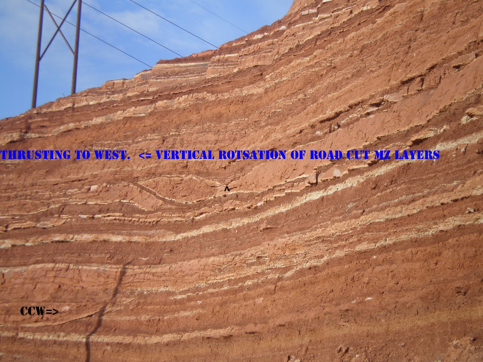
SUMMARY: Basalt plugs are the simplest type of extrusion, forming under the impetus of a MILANKOVITCH- type 100 k.y. or 1 m.y. elliptical rotation. The spread of the earth’s annual revolution about the sun is gradually lengthened by gravitational perturbations at nearby Moon, Planets and the Sun (Earth spirals further out and more slowly around the center of mass of the planetary system). As the earth slows (day length increases) and both enlarges overall while shrinking in the mid-section (bulge shortens at the equator, as centrifugal force decreases), it undergoes extension and basin formation N-S- creating 20 km/m.y. intervals of TIDAL SHEAR and avenues for basalt to rise at the base of the crust. Examples of these regular events occur at Crater Hill, Hurricane fault, and finally the Washington City fault- all separated by exactly 20 km- 1 m.y. intervals. The next volcano will occur at the “boiler” warm spring near I-15 freeway off the north feeder, and it has already shoved the ridge up to the east there. The Green Springs road and valley is the site of the present basin, which will yield a volcano. The time of extrusion- being within the million year interval- is yet to be solved, but the rate of uplift of the east side of the fault could be measured to mirror the sequence of vulcanism at Hf and Red ash crater in the town of Hurricane. The time also could be related to the extension north and south of the N-S Washington fault, and this could be measured with GPS annually. My calculations indicate that the uplift is about a millimeter annually, so that imminent extrusion would require an additional 10 meters uplift, or more than 5000 years. Exaggerations due to E-W extension of 20 mm/year are noticed, and this will shorten the time to extrusion (measured at the Middleton Mesa I-15 road cut-westward thrust of sedimentary redbeds,
and at the Laverkin Hogback fissures). NOTICE THAT LEEDS CRATER IS EXTRUDED FROM THE CENTER OF A ROTATING BASIN, AND THIS IS FOUND TO BE GENERALLY TRUE. THIS ACTION IS CREATED BY THE ELLIPTICAL ROTATION OF PORTIONS OF THE CRUST UNDER THE IMPETUS OF 100 K. AND 1 M.Y. MILANKOVITCH-TYPE MOVEMENTS OF THE EARTH TOWARD THE LARGE PLANETS OF JUPITER, SATURN, URANUS, AND NEPTUNE. THIS HAPPENS WHEN THEY TEND TO BE IN ALIGNMENT WITH EACH OTHER, CREATING UNUSUAL GRAVITATIONAL ATTRACTION OF THE EARTH. THIS ACTION ENLARGES THE DIAMETER OF THE EARTH, SLOWS REVOLUTION AROUND THE SUN, DECREASES THE EQUATORIAL BULGE AS CENTRIFUGAL FPORCE DECREASES, AND OPENS DEPRESSIONS IN THE CRUST:

Although the title suggests an action which seems contrary to reason, I will document this case, which is only one of five mechanisms of VULCANISM:
1. After local heating (HOT SPRINGS) by BRITTLE FRICTION, the case of small basaltic extrusions is the simplest expression of GEOTHERMAL HEAT DEVELOPMENT by ROTATION of a portion of the EARTH’S CRUST (e.g. Leeds Crater);
2. More siliceous extrusion develops at the edge of a regional rotation, CW, of a circular MILANKOVITCH CIRCLE, or cycle created by gravitational influence of the planets, moons, and the sun (e.g. Red Ash Crater in Hurricane, UT);
3. Larger MULTI-TYPE blasts, with rhyolite, basalt, and andesite occur at large regional intersections of two or more MILANKOVITCH CYCLES (e.g. San Francisco peaks, AZ);
4. Yellowstone type violent state-wide blasts (e.g. Krakatau) occur at the north edge (N. Hemisphere) of the intersection of hemispheric bulges and extension due to EARTH TIDES; and,
5. SUBDUCTION-TYPE vertical rotations of the crust downward, due to MANTLE DRAG (e.g. Mt. Baker, WA).
Below is that of a small rise of a basaltic plug, which is near my domicile and part of Sullivan Knoll:
 BOTH OF THESE "POP-UPS" EXIST IN SMALL BASINS, OF LESS THAN 100 METERS DIAMETER. NOTICE THAT THE SINKING CREATES A RIDGE SURROUNDING THE BASIN, AND THAT THE DOWNWARD MOVEMENT OF THE BASIN FORCES THE BASALT PLUG UPWARD TO OFFSET THE MASS TRANSFER. USING SHEAR LINES AND EXTRAPOLATION, WE WILL INVESTIGATE WHETHER THIS PERTAINS TO THE ORIGINAL MAGMA RISE FROM THE ASTHENOSPHERE (BASE OF CRUST) ACTING SIMILARLY. THAT IS, WHETHER THE SINKING OF AN ELLIPTICAL MILANKOVITCH ROTATION (CREATED BY THE EARTH BEING MOVED OUTWARD IN THE ELLIPSE, BY PLANETARY, SUN, OR MOON WOBBLE) HAS CONCOMITANT SLOWING OF THE EARTH'S VELOCITY IN SPACE (ENLARGING THE ANNUAL REVOLUTION PATH), EXTENSION OF THE CRUST, AND CREATION OF BASINS IN CYCLES OF 100 K.Y. OR 1 M.Y.
  THIS IS ILLUSTRATED WITH A DIAGRAM, WHICH RELATES THE ENTIRE PHENOMENON TO GRAVITATIONAL ADJUSTMENTS CREATED BY WOBBLES AND PERTURBATIONS OF THE EARTH'S ORBIT. I USED ABBREVIATIONS BECAUSE OF A SOFTWARE PROGRAM "GLITCH", AND EXTR. REFERS TO EXTRUSION, EXT. TO EXTENSION OF THE CRUST, AND HF TO THE HURRICANE FAULT. THIS IS TO ELIMINATE ANY REFERENCE TO THE MANTLE, EXCEPT FOR THAT AT THE ASTHENOSPHERE- WHERE A LATERAL MOVEMENT OF HOT PLASTIC ROCK MOVES AT THE BASE OF THE CRUST. THIS ALSO IS TO ELIMINATE FANTASIES ABOUT "HOTSPOTS, MANTLE PLUMES, AND MANTLE-CORE" MANIPULATIONS:
The digital photos show up-welling of small outliers protruding from larger extrusions, and are in the center of small sinking basins on the flanks of Sullivan knoll. It might be named a pop-up from a magma chamber, and can be classified and measured according to the diameter of the basin and its associated MILANKOVITCH-TYPE cycles. This one is centered within a 100 meter radius circular arrangement of edge ridges- which define the small basin (axial cycle of 40 k.years rotation). This illustrates the concept that there is a counter-current of magma uplift in a sink, with a time of development less than the age of the parent extrusion.
Extending this case to that of the whole volcano dome or crater, below is shown Leeds Crater:
 THE ENTIRE FEATURE CAN BE ANALYZED FOR AGE, DIAMETER, ELLIPTICITY RATIO= R1/R2 (IN BOTH E-W AND N-S DIRECTIONS), AND FOR A RATIO WHICH DEPENDS UPON THE TYPE OF ROTATION- WHETHER AXIAL (40 K), ELLIPTICAL (100 K), OR PRECESSIONAL (20-25 K,YEARS). THE PRECESSION OF THE EQUINOX IS NOT SUFFICIENTLY ACCURATE FOR AGE DETERMINATION, SINCE THE TILT OF THE EARTH- AS NOTED BY THE TROPICS OF CANCER AND CAPRICORN LATITUDES- CHANGES DURING THE CYCLE AND PERTURBS THE RATIO. THE FORMATION OF THESE VOLCANOES DURING ELLIPTICAL MOVEMENTS OF THE EARTH FAR AWAY FROM ITS NORMAL REVOLUTION IS AS FOLLOWS:
A. DURING A 100K.Y. ELLIPTICAL DEPARTURE FROM THE NORMAL EARTH-SUN ORBIT, THE GRAVITATIONAL EQUILIBRIUM IS SUCH AS TO MOVE THE EARTH FARTHER FROM THE SUN AND CLOSER TO THE LARGE PLANETS OF J,S,U, AND N. WHEN MOVING OUTWARDLY FROM THE SUN, THE EARTH SLOWS, ENLARGES AND SHRINKS IN ITS EQUATORIAL BULGE;
B. GRABENS, DEPRESSIONS, AND SINKS DEVELOP IN THE GRAVITATIONALLY-DROPPING BASINS;
C. DOWNWARD MOVEMENTOF THE CRUSTAL BASINS MOVES MASS TO THE EDGES OF THE BASINS AND TO THE CENTER OF THE ELLIPSE- FORMING AN EXTRUSION, AND AN UPLIFT AT THE OUTER DIAMETER (SUCH AS NOTICED AT THE EDGES OF THE HURRICANE FAULT);
D. PROOF THAT THIS IS NOT A MANTLE OR CORE PLUME OR OTHER HEAT PHENOMENON EXISTS WITH SALT DOMES. THEY PERFORM SIMILARLY, RISING FROM THE MESOZOIC SALT BEDS, WHICH EXIST AT SOME 10 KM DEPTH (NOT AT THE CRUSTAL BOUNDARY);
E. SINCE THIS OCCURS WITHIN THE ELLIPTICAL CYCLE(S), THERE WILL OCCUR ANOTHER EXTRUSION AT A LATER TIME. THESE ARE OBSERVED IN HAWAII, AND ARE NAMED REJUVENATION CONES. THEY OCCUR AT LATER 100 K.Y. MOVEMENTS, AND REQUIRE MULTIPLES OF THE 100 K.Y. TIMES- AS MUCH AS 1 M.Y. IN THE CASE OF HAWAII;
F. SMALLER MILANKOVITCH CYCLES OF 40 AND 25 K.Y. DURATION FORM AS A RESULT OF THE MOVEMENT OF THE EARTH BACK TO THE NORMAL REVOLUTIONARY ORBIT ABOUT THE SUN; AND,
G. SMALLER YET CYCLES ALSO EXIST, AND I HAVE FOUND ONES AS SMALL AS 5000 YEARS DURATION. ALL OF THESE CAN BE VIEWED ON GOOGLE EARTH, NEAR CONSTANTLY-MOVING FEATURES SUCH AS THE HURRICANE FAULT, THE MENDOCINO TRANSFORM, AND FOR THE HAWAIIAN CHAIN.
I HAVE THIS ANALYZED FOR THE NORTH AMERICAN QUADRANSPHERE, Qsna, AND WILL PUBLISH IT SHORTLY. IT WILL DEMOLISH ANY FANTASIES YOU STILL RETAIN ABOUT "HOTSPOTS, MANTLE PLUMES, AND RECTANGULARLY-SHAPED PLATES". ALL OF THIS HAS TO DO WITH THE MECHANICS OF THE EARTH, AS IT IS INFLUENCED BY ASTEROID STRIKES, CORIOLIS ROTATION ABOUT THE THRUSTS CREATED BY THE STRIKES, EARTH TIDES WHICH CONTINUE INDEFINITELY (20 KM/M.Y. IN NORTHERN HEMISPHERE), AND MILANKOVITCH-TYPE SHEAR OF ROCKS (WHETHER SEDIMENTARY OR IGNEOUS- BOTH OF WHICH CAN BE DATED BY THE USE OF GOOGLE EARTH AND ITS MEASUREMENT AND OBLIQUE TOOLS).
I HAVE BEEN EXPLORING THE WESTERN USA, AND IT WOULD BE INSTRUCTIVE TO COMPARE ALL OF THE ABOVE COMMENTS WITH A SINKING AREA OF WIDE EXTENT- SUCH AS THE GULF OF MEXICO, WHERE I GOT MY START AS A DRILLING ENGINEER. THIS WILL BE FURTHER SOUTH, SO THAT WE CAN CHECK SEVERAL CONCLUSIONS:
1. IS THE EARTH TIDE WESTERN RATE OF MOVEMENT LARGER THAN AT 45N LATITUDE?
2. IS THE CORRELATION OF ELIPTICAL CYCLES WITH GEOTHERMAL ZONES STILL PERTINENT?
3. DOES THE ORIENTATION OF ELLIPSES EITHER E-W OR N-S YIELD INFORMATION ABOUT THEIR FORMATION? AND,
4. ARE MILANKOVITCH CYCLES IN THE MIOCENE BASINS OF THE SAME DURATION AND TIME OF ROTATION?
 NOTICE THAT THERE ARE OBVIOUS 20 KM SEPARATIONS OF GRID LINES, AND THAT THERE ARE BOTH N-S AND E-W ELLIPTICAL ROTATIONS. THIS YIELDS A CONFIRMATION OF FEATURES FOUND IN THE HIGHLANDS OF THE WEST USA:
1. EARTH TIDES ARE WORKING IN A BASIN CREATED BY THE KT STRIKE OF CHIXCULUB, YUCATAN, MEXICO. THE SAME MEASUREMENT ON AVERAGE OF 20 KM/UNIT IS FOUND AT THIS 20N LATITUDE AS WAS FOUND FOR MID-LATITUDES IN THE FOUR CORNERS AREA (AND IN THE NORTH PACIFIC BASIN);
2. EXTRUSIONS OCCUR, BUT NOW IN THE FORM OF SALT DOMES. THESE ROTATE CCW AS THEY RISE, AND MAKE A LATERAL "TURN" AT ABOUT THE 1000 METER DEPTH. I HAVE INVESTIGATED THESE INTENSIVELY IN MY TEXAS DAYS, AND FIND THAT HAVE AN OPENING (SINK) IN THE TOP AS SHOWN IN RISES OF THE WEST. THIS OCCURS AS A FRESH WATER LAKE, WITH A CIRCULAR PATTERN- AS IN AVERY ISLAND, LA;
3. THIS SHOULD DISMISS ANY THOUGHTS THAT THE RISING EXTRUSIONS ARE DUE TO MANTLE PLUMES, SINCE THE BASE OF THESE SALT DOMES IS AT THE LOUAN SALT BEDS OF MESOZOIC AGE (THE PLASTIC SALT ACTS SIMILARLY TO THE ASTENOSPHERE OF THE CRUST IN THE WEST USA); AND'
4. THIS COMPARISON YIELDS SOME TENTATIVE CONCLUSIONS, WHICH WE WILL CHECK WITH OTHER MEASUREMENTS AND MEANS:
a. THE TIDAL MOVEMENT OF 20 KM/M.Y. IS NOT CHANGED WITH LATITUDE, AS I SUPPOSED. IT REMAINS AT A FAIRLY CONSTANT MAGNITUDE IN THE NORTHERN HEMISPHERE, INDICATING THAT THE COMBINATION OF SUN+MOON TIDES HAS COMPENSATION WITHIN THE ZONE- THAT I CALL THE EQUATORIAL BULGE (40N AT MENDOCINO CA). IT IS POSSIBLE THT THE ANALEMMA ROTATION (SEE BELOW) OF THE SUN IS SUCH AS TO MAKE THE COMBINATIOIN OF SUN+MOON TIDES REMAIN AT 20 MM/YEAR AS LATITUDE CHANGES. THIS HINTS THAT THE ROTATIONS AT THE OLYMPIC MOUNTAINS (BEING NORTH OF EB) ARE DUE TO THIS INFLUENCE OF THE SUN VERSUS MOON (AND OTHER PLANETS) AS THE GRAVITATIONAL RE-ARRANGEMENTS OCCUR. WE'LL INVESTIGATE THIS POSSIBILITY.

b. AS OBSERVED IN MY "OIL EXPLORATION" DAYS, ONE SIDE OF AN OILFIELD HAS A HIGHER THAN AVERAGE TEMPERATURE. THIS, I ASSUMED AT THE TIME, WAS THE LOCATION OF THE VERTICALLY-MOVING FLUIDS. THIS FEATURE CAUSED CHAGRIN WITH THE GEOLOGY CULTURE- WHO ASSERTED THAT ALL WAS MOVING HORIZONTALLY. THE EARTH IS DE-GASSING, AND THE HOT FLUIDS TAKE THE VERTICAL FRACTURES AND FAULTS TO MOVE UPWARD WITH TIME INTO TEMPORARY TRAPS. FLUIDS MOVE VERTICALLY, UNTIL FINDING TEMPORARY RESIDENCE IN ROCKS WITH LOW PERMEABILITY CAPS. ROCKS MOVE LATERALLY, WITH OBVIOUS VERTICAL DISPLACEMENT, AND THIS AGAIN REMAINS UN-NOTICED BY THE CULTURE- MISSING THE IMPORTANT LATERAL FEATURES CREATED BY MILANKOVITCH CYCLES AND EARTH TIDES (NOT TO MENTION CORIOLIS ROTATIONS WITH EVERY ASTEROID STRIKE- WHICH CREATES LOCAL THRUSTING).
 ABOVE IS THE VIRGIN OILFIELD, UTAH (NOW ABANDONED), WHICH IS BOUNDED BY ELLIPICAL AND AXIAL ROTATIONAL CELLS, AND BELOW IS THE VIRGIN ANTICLINE WHICH HAS OIL "SHOWS" BUT NO HYDROCARBON PRODUCTION:
Since we will be referring to vulcanism associated with the 2.15 m.y. ELTANIN asteroid strike, let’s look a the pattern developed by the CRATER HILL vulcanism inside Zion NP. The basalts to the north of this are the oldest in the area, and there is a spiral formed as the extrusions proceeded to the south and east. Earth tides form a N-S linear each 20 km, and this has the crater 20 km from the Hurricane fault (due west, 1 m.y. AGE).


This indicates that the feature started in the edge of the expected 20 km “tic” from the one million years estimated starting point. I have found that the CRUST of the EARTH regularly moves land masses westward by 20 mm/year or by 20 km “jerks” each million years. There are both MOON and SUN-EARTH TIDES, so that both have to be taken into account. Measured, so far, are 10 mm/year for the sun (sometimes 5 mm/y.), and 20 mm/year for the moon; at the equator, this would be the approximate westward movement. This movement depends upon the Latitude, since there is no westward shift at the poles. The combination is 30 mm/year at the Equator, x trigonometric sin of 45 degrees at mid latitudes = .707 x 30= 21 mm/year. This small error of 7% is smaller than the expected measurement and translation inaccuracies, and we will use 20 km/m.y. at USA latitudes:

Google earth shows that basalt vulcanism (the smallest category)derives from ELLIPTICAL Milankovitch rotation- either 100 k.y. or 1 m.y. I anticipate that the following events create this effect:
a. Gravitational changes due to DEVIATIONS OF ORBITS of other planets, the moon, or the sun increase the attraction of EARTH to the resultant center of mass:
b. The locations on the CRUST which are impinged SINK (creating basins), due to the expansion of the earth as it moves further from the center of mass (increasing its distance from the sun). This increase of EARTH-SUN SPACING extends the ORBIT of the earth about the sun and slows the earth’s travel of revolution. The overall effect is to shrink the earth by contraction-compression, and to enlarge it by expansion- thereby forming local, regional, and large basins according to the extent of the ellipse diameter from the original path of the earth (RIDGES ARE FORMED BY COMPRESSION, and there is a cycle to all this- see the Gulf of Mexico below);
c. Milankovitch has calculated that there is an elliptical diversion of earth from its normal revolution about the sun each 100 k.years. I have found that after the Eltanin strike of about 2 m.y, there occurred a 1 m.y. ellipse, as shown by shear of outcrops in the SW deserts (and other regional locations). I do not extrapolate back into geologic time further than 2.15 m.y., since I get hints that previously there were other events which changed the 20 km/m.y. tidal changes or GRID SPACINGS- which must be measured for earlier TIME PERIODS; and,
d. I expect that multi-basaltic extrusion events, such as Divide-Ivins Knoll duo were arranged in an elliptical pattern, and the first look at this is shown below:

A comparison with Iron Mountain, an event occurring in earlier Tertiary (before the Pleistocene), is shown below to contrast the spacings of shear lines and rotation diameters with that of the Quaternary analyses:


COMPARE THE PREVIOUS PHOTOS WITH ONE FROM THE SE CORNER OF THE PINE VALLEY MOUNTAINS, PVM (WHICH IS EXPECTED TO HAVE DIFFERENT RATIOS OF MILANKOVITCH CYCLE DIAMETER TO EDGE CYCLE RADIUS MEASUREMENTS):

DIVIDE VOLCANO, WHICH STRADDLES THE HURRICANE FAULT AT A DRAINAGE DIVIDE, IS LIKELY THE OLDEST EXTRUSION ALONG Hf, WITHIN THE GRASS VALLEY ROTATION FROM THE VIRGIN RIVER TO HORSE VALLEY, TO FORT PIERCE WASH, TO THE WASHINGTON FAULT. THIS IS USEFUL TO STUDY, SINCE IT HAS HAD TIME FOR SEVERAL SUBSEQUENT ACTIONS:
a. Hf HAS MOVED SOUTH, UNDER THE IMPETUS OF CP ROTATING CCW (EAST SIDE MOVING SOUTHWARD). THIS MOVES THE DIVIDE BASALT SOUTH ON THE EAST SIDE AND NORTH ON THE WEST SIDE. CONSEQUENTLY, THE TWO PREVIOUSLY CONNECTED FLOWS ARE NOW SEPARATED, AND THE WESTERN PORTION HAS ROTATED ACCORDIN TO THE PICTURED ARCUATE PRESENTATIONS;
b. THERE HAS BEEN MOVMENT OF Hf TO SEPARATE THE SPILL OVER THE EDGE TO THE WEST, AFTER UPLIFT AND SPALLING. THIS CAN BE MEASURED ON GOOGLE EARTH; AND,
c. THE LANDSCAPE HAS BEEN LIFTED AT THE DRAINAGE DIVIDE, WHILE BEING SLICED BY Hf:
 THE SLUMP MOVEMENT TIME CAN BE CALCULATED, PROVIDING THE WESTERN RATE OF 20 MM/YEAR IS PERTINENT. THIS SLIDE WAS PROBABLY SLOW, BEING TRIGGERED BY THE 20 K.YR. PRECESSION OF THE EQUINOX. THIS CASE EXHIBITS HOW THIS PRECESSIONAL MILANKOVITCH CYCLE HAS SIGNIFICANT VARIATION OF TIME OF ROTATION- CHANGING FROM 20.5 TO 24.5 DEGREES OF TILT (THIS DETERMINES THE LATITUDE OF THE TROPICS OF CANCER AND CAPRICORN). DO NOT USE THIS ONE FOR AGE CALCULATION, SINCE THERE IS A POSSIBLE 25% ERROR!
  THERE IS A DISPARITY BETWEEN THE EAST AND WEST PORTIONS OF THE DIVIDE VULCANISM- CALCULATING A YOUNGER AGE ABOVE THE Hf CLIFFS. WE WILL MAKE ANOTHER FIELD HIKE ON THE PORTION WEST OF Hf, IN APRIL 2011, TO ADD DIGITAL PHOTOS.AS OF NOW, THERE HAS BEEN SUFFICIENT TIME (MORE THAN 1 M.Y.) TO ROTATE- BY PRECESSSINAL, AXIAL, AND ELIPTICAL CYCLES- BOTH SEGMENTS OF THE BASALT FLOW- ADDING TO THE COMLEXITY OF THE ANALYSIS.
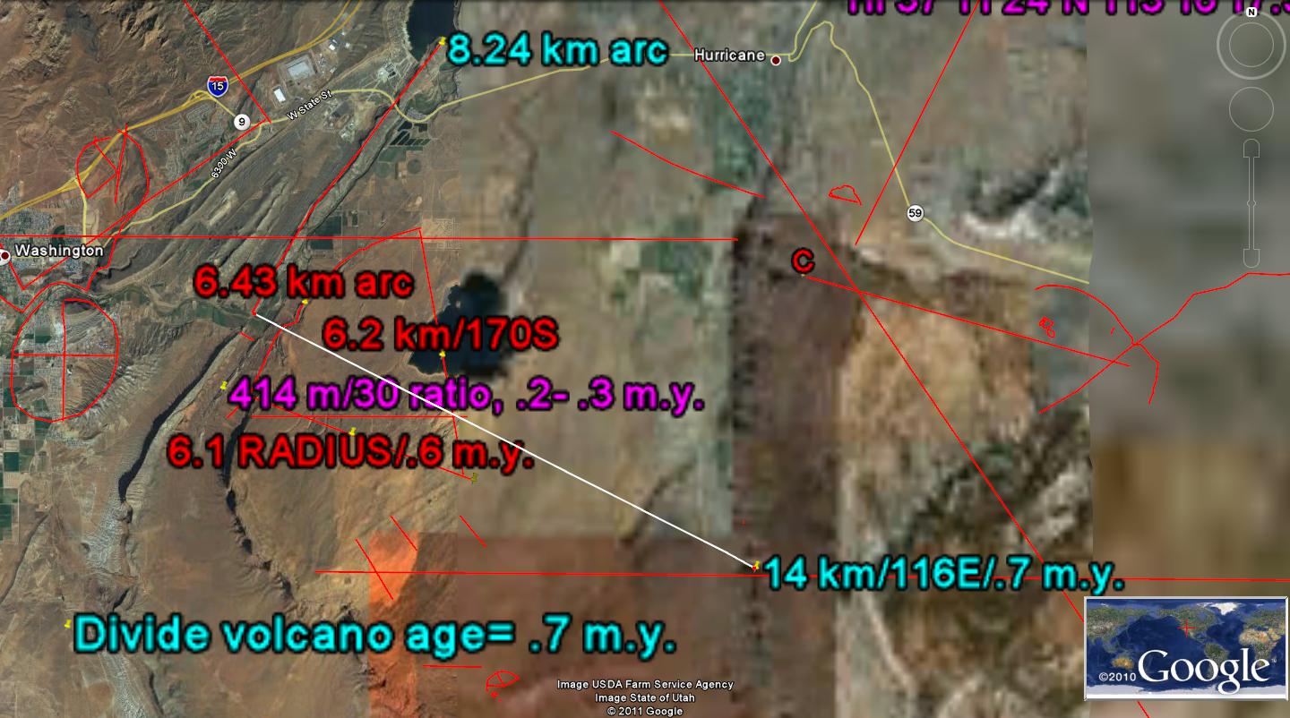
 PHOTOS TAKEN DURING THE FIELD HIKE ON 4/28/2011 INCLUDE A LOOSE BASALT BOULDER'S SLICKENSIDES (THE LATERAL STRIATIONS ARE NOT INDICATIVE OF ACTUAL DIRECTION OF ROTATION), AND VIEWS FROM ATOP THE DOME, JUST WEST OF THE DRAINAGE DIVIDE YIELD INFORMATION ABOUT THE RISE, SHEAR, ROTATION, AND TRANSLATION OF THE DIVIDE MULTI-FLOWS:

 ABOVE GOOGLE EARTH PLAN VIEW SHOWS THAT THE DIVIDE VULCANISM IS SURROUNDED BY MILANKOVITCH ELLIPTICAL SHEAR, AS INDICATED BY DRAINAGES AND CANYONS IN Hf CLIFFS. THIS CONFIRMS, AGAIN, THAT VULCANISM IS PRODUCED BY SINKS WHICH ARE CREATED BY INCREASE OF THE EARTH'S ANNUAL DISTANCE FROM THE SUN (WITH ELLIPTICITY). THIS NOT ONLY CAUSES COOLING OF THE EARTH (MINI-ICE AGES), BUT IT ALSO CREATES GRABENS (THE EARTH EXPANDS WITH SLOWING AS THE ORBITAL DISTANCE INCREASES, AND DEPRESSIONS AND SINKS ARE CREATED BY THE EXTENSION). I HAVE FOUND 2 AGES OF ELLIPSES: THAT CALCULATED BY MILANKOVIOTCH AT 100 K.Y. (WHICH IS USEFUL FOR AGE CALCULATION, MUCH MORE ACCURATELY THAN THE PRECESSIONAL 23 K.Y. CYCLES), AND 1 M.Y. CYCLES- WHICH I PROPOSE ARE IN RESPONSE TO THE 2.15 M.Y. ELTANIN STRIKE.
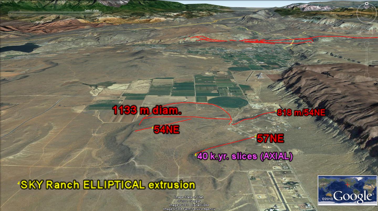 SKY RANCH IS A VILLAGE WITH ITS OWN PRIVATE AIRPORT; IT IS LOCATED SOME 6 MILES SOUTH OF SULLIVAN KNOLL, IN THE TOWN OF HURRICANE. IT LIES JUST EAST OF A BINARY VOLCANO- WHICH CAN BE VIEWED IN THE ABOVE GOOGLE PHOTO. THE CRATERS FORM AN ELLIPSE, WHICH WAS CREATED DURING A MILANKOVITCH CYCLE OF 100 K. OR 1 M.Y. ROTATION. AN ELLIPSE IS FORMED BY THE UNUSUAL ATTRACTION OF JUPITER, SATURN, URANUS, AND NEPTUNE (WHEN THEY ARE CLOSELY ALIGNED- SUCH AS DURING APRIL 2011).
 ABOVE AND BELOW ARE SHOWN PHOTOS WHICH SHOW THE ALIGNMENT OF THE BINARY IN A N-S DIRECTION. NOTICE THAT THE TILT IS DOWN TO THE RIGHT, AS WAS SHOWN IN THE MODEL DIAGRAM FOR A ROTATING AND SINKING FEATURE; THIS LEAVES ITS IMPRINT IN THE ROCKS AND ELEVATION CHANGES:
 ABOVE PHOTO SHOWS THE ANCIENT EXTRUSION, AND GOOGLE EARTH ALLOWS THE ANALYST TO MEASURE OR CALCULATE SEVERAL FEATURES:
1. THE TYPE, WHICH IS DISTINGUISHED BY 40 K.YR. AXIAL ROTATION, AND WHICH HAS A RATIO OF 50:1 FOR DIAMETER:EDGE SHEAR PARALLEL OR CONCENTRIC ROTATION LINES, BY 100 K. ELLIPTICAL ROTATION, OR BY 20-25 RATIO PRECESSIONAL CYCLES- WHICH CANNOT BE RELIED FOR ACCCURACY.
2. AGE, WHICH CAN BE CALCULATED IN SEVERAL WAYS:
a. DIAMETER IN AN E-W DIRECTION DIVIDED BY 20 KM/M.Y.- WHICH IS THE MOVEMENT BY EARTH-MOON SUN TIDES IN THE NORTHERN HEMISPHERE. YOU MUST USE DIAMETER IN KM, FOR THE AGE TO BE STIPULATED IN M.Y.
b. RATIO OF THE E-W DIAMETER TO A 100 K.Y. ELLIPSE. WHEN THE DIAMETER IS TWICE THE ELLIPTICAL DIAMETER, THE AGE IS 200 K.Y. THIS IS ACCURATE WITHIN 12%, COMPARED TO RADIO-ACTIVITY DATING.
c. WHEN THERE IS NO ELLIPTICITY, AS MEASURED BY THE R1/R2 BEING LESS THAN 1.2, THEN THE AXIAL CYCLE DATING MAY BE USED. THIS CYCLE IS ACCURATELY MEASURED AS 41 K.Y. BY MILANKOVITCH, BUT FOR THE BINARY SERIES OF 2, 4, 8, 16, 32, 64 ETC. AND 10, 20, 40, AND 80, WHICH ALLOWS SOME SLACK OF EXTERNAL INFLUENCES IN THE UNIVERSE (INCLUDING OUR OWN 10% FREEDOM OF CHOICE), I USE 40 K. AS THE BASE. THEN FOR A DIAMETER OF 1000 METERS (1 KM), THE AGE IS CALCULATED AS MULTIPLES OF 41 K/PI YEARS. 13 KM IS EQUIVALENT TO 40 K.YEARS.

COMPARE THE MOVEMENTS OF THE EARTH NEAR VOLCANOES, TO THAT WHICH YOU HAVE SEEN ON YOUR TELEVISION RECENTLY, ON WEATHER PORTRAITS- WHETHER ON SATELLITE DISH OR FROM THE WEATHER CHANNEL. YOU HAVE 2 SINKING ATMOSPHERIC CELLS (HIGH PRESSURE, ROTATING CW) CONVERGING IN THE SE USA DURING APRIL 25TH, 2011. THE TWO WOULD CLASH, CREATING CONSIDERABLE WIND SHEAR, EXCEPT THAT AS THEY APPPROACH, THERE IS A "BUFFER" WHICH ACTS TO INCORPORATE BOTH CW MOVEMENTS. THIS IS THE CCW CELL, WHICH ABSORBS ALL OF THE ENERGY OF THE CLASHES, BUT NOW WITH VIOLENCE AT THE GROUND SURFACE (DESTROYING HOUSES). YOU INQUIRE "WHAT HAS THIS GOT TO DO WITH VOLCANOES?" THE ANSWER IS THAT "BOTH OF THESE ARE FORMED BY THE UNUSUAL ATTRACTION OF THE LARGE PLANETS TO THE SIDE OF THE EARTH FACING THEM- IN WEATHER MAKING RISING TORNADOS, AND IN THE CRUST OF THE EARTH, MAKING RISING VOLCANOES". BOTH OCCUR FROM THE ELLIPTICAL MOVEMENTS OF THE EARTH, REPEATING IN 100 K. OR 1 M. YEARS FOR VULCANISM, AND DAILY FOR AIR MASS WHICH HAS ONE 10 BILLIONTH OF THE VISCOSITY OF THE CRUST OF THE EARTH, AND BOTH FORM AT SINKING FEATURES- EITHER BASINS IN THE CRUST, OR SINKING HIGH PRESSURE CELLS FOR THE ATMOSPHERE. IN ONE CASE VOLCANOES ARE EXTRUDED, AND IN THE OTHER THE AIR IS SQUEEZED UPWARD, RISING WITH LOW DENSITY AIR (MOIST AIR IS LIGHTER THAN DRY AIR- WHICH SINKS). YOU WILL ALSO NOTICE THAT TORNADOS "TILT" AS THEY SWEEP ACDROSS THE PLAINS, AND VOLCANOS TILT TO CREATE THE DIP ANGLE NOTICED IN THE ABOVE PHOTOS.

SKY RANCH VULLCANISM IS ONE OF THE OLDEST OF THE EXTRUSIONS ALONG THE HURRICANE FAULT, NEAR THE TOWN OF HURRICANE. IT IS INSIDE SEVERAL MILANKOVITCH 100 K.Y. ELLIPSES, AND WE WILL USE THAT FEATURE TO CONFIRM A LOWER LIMIT AGE FOR THE FEATURE. NOTICE THAT THERE IS TILT TO THE EAST, AND THAT THERE IS AN INFLECTION (CHANGE OF ORIENTATION OF Hf) AT MOLLY'S NIPPLE- A PROMINENT LANDMARK STANDING ABOVE OTHER PEAKS AND MESAS IN THE REGION:

REMARKS AND ANALYSES SHOWN ON FOLLOWING PHOTOS SHOW THAT THERE ARE AT LEAST THREE 100 K.Y. ELLIPSES, AND THIS MEANS THAT THERE HAE BEEN AT LEAST 300,000 YEARS SINCE THE FEATURE FIRST AROSE. WE NOW NEED TO FIND AN UPPER LIMIT TO THE AGE:
CONTINUING WITH THIS COMPLICATED SET OF MOVEMENTS, REMEMBER THAT WE HAVE AT LEAST 3 INTERFERING ROTATIONS IN THE AREA:
1. THE HURRICANE FAULT IS MOVING WITH THE COLORADO PLATEAU CCW ROTATION- SOUTHWARD ON THE EAST SIDE;
2. THE GRASS VALLEY ROTATIONS PROCEED CW, FROM THE VIRGIN RIVER TO ZION NP, TO HORSE VALLEY, TO FORT PIERCE WASH, AND THROUGH THE WASHINGTON FAULT BACK TO THE VIRGIN RIVER (ARCUATE, CIRCULAR "ROUND" SHEAR CIRCLES); AND,
3. ZION UPLIFT IS SPIRALLING UPWARD (RISING, NOW) WITH A CCW ROTATION, CREATING SHEAR CANYONS FASTER THAN THEY CAN ERODE. ROCK CLIMBERS LOVE THIS, BUT GRAVITY RULES THE DAY!
REVIEWING, LOOK THE REGIONAL PHOTOS AGAIN:
 AND FINALLY, THE MAP, IN AN OBLIQUE ATTITUDE, OF THE ENTIRE REGION OF QUATERNARY VOLCANOES- FROM THE DIVIDE TO SULLIVAN KNOLL IN THE TOWN OF HURRICANE:
SUMMARY: Basalt plugs are the simplest type of extrusion, forming under the impetus of a MILANKOVITCH- type 100 k.y. or 1 m.y. elliptical rotation. The spread of the earth’s annual revolution about the sun is gradually lengthened by gravitational perturbations at nearby Moon, Planets and the Sun (Earth spirals further out and more slowly around the center of mass of the planetary system). As the earth slows (day length increases) and shrinks (diameter shortens at the equator, as centrifugal force decreases), it undergoes extension and basin formation N-S- creating 20 km/m.y. intervals of TIDAL SHEAR and avenues for basalt to rise at the base of the crust. Examples of these regular events occur at Crater Hill, Hurricane fault, and finally the Washington City fault- all separated by exactly 20 km- 1 m.y. intervals. The next volcano will occur at the “boiler” warm spring near I-15 freeway off the north feeder, and it has already shoved the ridge up to the east there. The Green Springs road and valley is the site of the present basin, which will yield a volcano. The time of extrusion- being within the million year interval- is yet to be solved, but the rate of uplift of the east side of the fault could be measured to mirror the sequence of vulcanism at Hf and Red ash crater in the town of Hurricane. The time also could be related to the extension north and south of the N-S Washington fault, and this could be measured with GPS annually. My calculations indicate that the uplift is about a millimeter annually, so that imminent extrusion would require an additional 10 meters uplift, or more than 5000 years. Exaggerations due to E-W extension of 20 mm/year are noticed, and this will shorten the time to extrusion (measured at the Middleton Mesa I-15 road cut-westward thrust of sedimentary redbeds, and at the Laverkin Hogback fissures).
2 comments:
Hello Harold, we spoke earlier about Mima Mounds, and I think I found the park where my husband and I went.
http://www.dnr.wa.gov/AboutDNR/ManagedLands/Pages/amp_na_mima.aspx
http://www.southsoundprairies.org/visit.htm
http://thecentralcascades.com/mima-mounds-natural-area-preserve/
It was good talking to you.
Alicia
I found the Mounds near Olympia, and used their PIX for the blog. Reply to overtonharold@yahoo.com I searched for golden paintbrush near your house, but the MOWER beat me! If you see them please photo, as the season is almost over. I have lots of extra info in a newer blog, but google won't post lately! Any suggestions? HLO
Post a Comment