
Before you scan these Case Histories, here are some guidelines, which I have found by determining the common features for the 100 or more Rotating Coriolis cells investigated (mostly in the NA Quadransphere):
1. The shear zone width of a circular cell’s boundaries is about 1/200th of the diameter of the cell- e.g., for the Grass Valley (Virgin River-north boundary), shown above, it is about 100 meters for a 20 km cell N-S:
2. The direction of rotation is found by determining the direction of “cat scratches or tracks”- which are claw marks “dug in” by chert or hard particles of the adjoining surface in the direction of travel;

3. Vertical rotation is found by examining GPS positioning of a feature (rising vs. sinking), or by determining the preponderance of grabens and sinks compared to uplifts or compressional features (e.g. B&R vs. CP);
4. Am ellipse is formed wherever the Coriolis Rotation is constrained by a larger phenomenon- such as the Great Cell of B&R impinging on the somewhat smaller cell of the Sierra-Sacramento Valley rotation;
5. The outer realm of a rotating cell has the faster velocity, compared to that near the center of the cell- where velocity is near nil;
6. Coriolis cells rotate about a linear feature such as the Hurricane fault, Hf, and if not, then the cell is a Reactionary Cell, which is forcibly rotating because of two moving borders- such as the Valley of Fire, NV thrusts;


and,
7. The size of the cell determines the rotational velocity, where larger cells are slower, compared to local or regional ones.

The Structural Geology of the Western NA Quadransphere is dominated by four main factors:
1. Latitudes greater than 10N or 10S have Coriolis rotations determining the movements of landmasses and Structural anomalies, until reaching the edge of the Equatorial Bulge, EB;
2. 40N and 41S Latitudes (approximately) incur shear between the EB and latitudes greater, where there is less slowing of the Earth's spin (less tidal friction from the Moon-which increases LOD), relative to lower latitudes. Consequently reactions are somewhat disconnected from the first type of anomalies;
3. Meteor or asteroid strikes re-arrange the Polar Axis (hence the Equator and EB), so that there may be relict (fossil) traces of previous shearing action exhibited;
4. The fourth factor- cycling of the magnetic polarity- is shown by cycles of parallel grids south of the "Big Island" of Hawaii, about 200 k.years apart, and this feature is out of my range of operation, but I will record these grids wherever found (so far at three locations on Google Earth).
The first case presented is that of our neighbors- the West Indies:

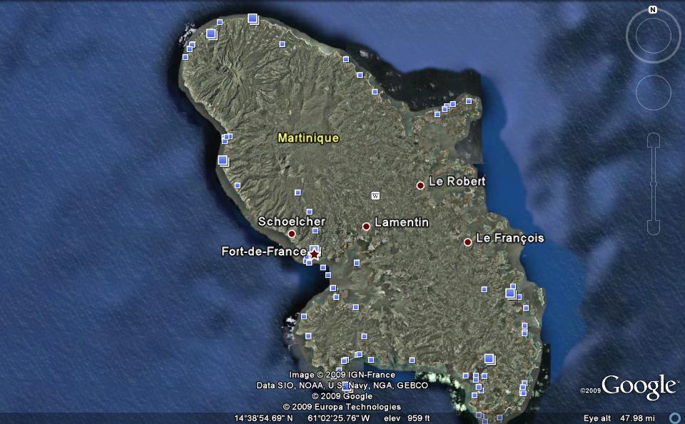
The island of Martinique is shown separately, since it has a fairly recent history of extrusion. The violent eruption in the 20th century (1902)is reported to have killed everyone, except a prisoner (incarcerated in a somewhat thermally-insulated underground cell). You can expect that this type of blast was siliceous-inspired and not a basaltic flow from the Mantle. In other words, this was NOT a Mantle Plume, "hotspot", plate movement, or other asserted classification. The above photo shows that it is near a conflicting CORIOLIS ROTATION and linear displacement in the West Indies.
Below are my analyses:

Iceland as a global phenomenon (Quadransphere, in this case):
 Above shows a large view of Iceland, as it is situated in relation to the MAR and to Coriolis Tectonics. Below, Iceland is enlarged, so that you can see the relation to circular rotation and shear between similarly-rotating cells.
Another complicated geological anomaly is that of Death Valley, DV, on the border of CA, junctioning on a diagonal 45 degree line with the state of NV. This region is at an elevation, at its lowest point, below sea level. Normally, the Geology Culture has classified it as a simple Basin and Range structure, B&R, but the Coriolis Rotation theory now requires it to be re-examiined. The Photos from Google Earth aligns it with the CA-NV border, so as to get a maximum view of the ellipse:
 Death Valley is an impingement between the Sierra-Valley and B&R cells The following Diagram shows a model for the intermediate position of Death Valley between the CA vertically and horizontally-rotating elliptical cell and the Basin and Range region (which is also vertically and horizontally rotating within the Crust).
This is a tough one! Not only do we have the diagonal-ellipse of the Sierras-Sacramento rotating two ways (3D- horizontally and vertically), but we have the B&R impinging on both at Death Valley- creating a double feature dominant fault system (diagonal to each other) within the National Park. This is a three-dimensional geometrical arrangement, involving the Coriolis rotation of the Crust, horizontally, within the three states of CA, NV, and UT, and for the two cells rotating, vertically and separately, for NV (B&R) and CA (Sierras uplifting). Look at the photo I made of a fault tracing N-S in the DV basin, and notice that it has not only created vulcanism by the shear of the general area, but the shear has continued- to produce a N-S fault through the extrusion created by the HEAT from the process:


This is going to take some field work- which I will perform in December. More to come!
Anyone interested in comparing my analyses with an area of interest (preferably in the NA Quadransphere) may comment below and get my analysis for areas (where they have command of the structural geology). I have worked in several areas of the world, so will not eliminate any of them.
I will conintue to post analyses of areas where there is an internationally-known anomaly- such as Valley of Fire, NV (next) or geothermal fields- but can temporarily relate to any area that you suggest.
No comments:
Post a Comment