An Example
of shearing versus rotating, which results in DRASTIC FAULTING, HEAT GENERATION and EARTHQUAKES, is shown with the TRANSFORM FAULTING at the
California coast; the transforms are spaced 7.2 degrees of Latitude apart, and
rotate away from this regularity in a Great ARC. This is EQUIVALENT to 800
kilometers on the VERTICAL LATITUDE SCALE, and represents 1/50th of the 360
degree circle, or 800/40,000 on a CURVILINEAR EARTH:
The relationship may be MATHEMATIZED with the
following EQUATION:
(A/B) x 360=
{(1/4)® x (A+B)/360}, where ®= an exponent, with values from -4 to +4, including
zero. For zero, (1/4)®= 1. This Sierras Range,CA case is the simplest, with the
800 km distance and 360 degree circle:
(512/288) x 360=
640 = 1 x (512+ 288= 800) x 288/360= 640, or 400 x 1.6.
Note that the RATIO 512/288 or any larger RATIO of numbers with MULTIPLES of 16/9= 1.7777+; 16+9 = 25, where the investigated multiple-harmonic occurs in the
BINARY THEOREM SYSTEM: 2, 4, 8, 16, 32, 64, 128, 256, 512, 1024, 2048, and 4096,
yields the IRRATIONAL NUMBER 1.7777+, which is an IMPORTANT MEASUREMENT NUMBER
for the Earth’s CRUST-OUTCROPS. This numbers’ 1000x HARMONIC occurs for the
QUADRANSPHERE of North America, for linear distances from Mendocino, CA south
to obvious COASTAL ANOMALIES, and for the “TIT” of Alaska’s PARALLELOGRAM of a 4-sided 1777.7+ km POLYGON.


Smaller distances, such as 400= A+B, have the exponent of -1,
-2. etc., and result in:
256/144) x 360= 640= {(4)(400) x 144/360}= 640, where the exponent
is necessary for the 2 squared mathematics.
Larger distances, e.g.1600km for the Owen Stanley Mountains
LINEAR, RESULT in:
1024/576) x 360= 640= {(1/ ATTEMPT THIS ONE YOURSELF!These 800, 1600, 2400, 3000 km distances show up as LINEARS on a broad view of Google Earth, for several Mountain RANGES: Sierras, Owen Stanley, Atlas, and Andes, for example, and represent Graviational UPLIFT (vertical ROTATION) near oceans:


The CANADIAN CRATON exhibits 1600- 2500 km LINEARS, and is calculated to be of 2.5 b.y. AGE, MAXIMUM. Geologists have RADIO-DATED this feature to be 3.0+ b.y., and we must determine which is more correct! This feature is EXPANDING 1 mm/year, as is the MAIN ORB to the south, and I am inclined to believe that the craton is a "TIT" off the 4096 m.y. CONTINENTAL BULGE to the south. This will have to be proved with reference to similar bulges in other continents (Africa, South America and Australia). Australia has ROCKS of almost 4 b.y. AGE, and is the one to analyst first:

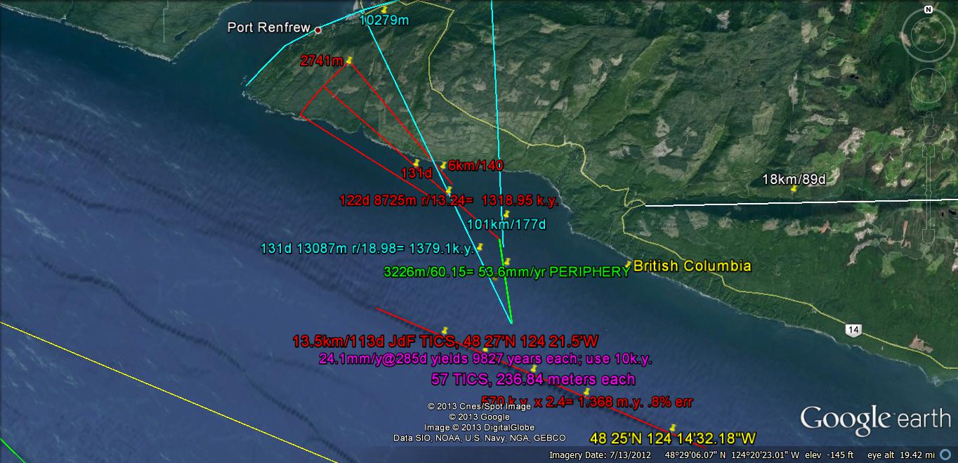
This is REFERENCED to the SHARP TURN at the entrance to the channel of Juan de Fuca, using the PERTINENT PARALLEL INDICATIONS. Added info is shown with an additional analysis:

This is ILLUSTRATING that the LAND MASS of the North America CONTINENT has a DIVISION at the SdF to 45N latitude at the GREAT LAKES, USA! This calculates the reference of 1.6 ratio, which is created by Venus; Further, TRIANGLES are exhibited, rather than POLYGONS, and I believe that this is a function of LATITUDE. A CHANGE OCCURS at the 45 degree HALF WAY POINT to the poles, as happens at The Caspian Sea with its influence of Venus and the 1.6 ratio. Latitude is proving to be a SIGNIFICANT FACTOR for EARTH TIDES, CORIOLIS ROTATIONS, and POLAR WOBBLE!
Below is another view of SdF to the Olympic Mountains, to view the LATITUDE INFLUENCE:


The LATITUDE of the Olympics is closer to 48N, so that the CURVILINEAR to the Great Lakes is not along a PARALLEL of LATITUDE- it is a GREAT ARC!

"TIC" MARKS are revealing INFORMATION which is not obvious! The AGE of the MOVEMENT is near 10 k.y. per tic, in this case, and we still have to prove that this is accomplished by the Mars GRAVITATIONAL FIELD:

The JdF channel, at a CRITICAL LONGITUDE, DIVIDES the North American QUADRANT, Qsna- quadransphere, in a Northern part without Cascades to the southern 800 km VOLCANIC EXTRUSIONS. Consequently, Canada has the INTRUSIONS (in the NE), while CA to WA exhibits BASALTIC VULCANISM- in the NW! The CRATON is a part of this division; it exhibits POLYGONS with sides less than 6, compared to 5, 8, 10 or more in the USA middle latitudes:

I am sure that this division can be seen MATHEMATICALLY, and will work it out- using OTHER CONTINENTS, where other CRATONS are displayed (Australia, Africa, and South America). Each of these EXHIBITS a DISTINCT LINEAR- in terms of the LENGTH, ANGULAR ORIENTATION, and the SALT WATER BODY facing it!

Africa above, and Australia, below, show the 4096 km PRESENT DAY ORB (the continental mass, which has EXPANDED LATERALLY( and risen upwardly)1 mm/year, SINCE INCEPTION 4096 million years ago:

Comparison of PHYSICAL FEATURES below
and north of 45N Latitude:
In Qsna, for the LANDMASS of the continent,
the fairly-stable Canadian CRATON lies above this 45N half-of-the hemisphere
PARALLEL. The multiple 2 (inverse half) is the base of the BINARY SERIES, where
both TIME and SPACE are involved PHYSICALLY. The most noticeable changes are:
1. Pentagons to Octagons give way to
TRIANGLES and trapezoids, e.g. Great Slave Lake and the 3 or 4-sided figures
inside the craton;
2. Cones are prominent along the
metamorphic outcrops of the INLAND PASSAGE;
3. Basins are rare in the hard rock
cratons, and the fairly-common Mima Mounds, SOUTH OF THE BORDER, are noticed as
Metamorphosed CONES (the cross-section of which is a triangle);
4. The RATIOS of 1600/1000= 1.6- which is
most common to the south- gives way to 1280/1000= 1.28, which I have postulated
as being part of the 1.25n series: 1.28 Mercury, 1.6 Venus, 2.0 Mars, and 2.5
Jupiter. This series continues for the 7 planetary gravitational influences,
but the larger numbers are NOT SIMPLE (3.125 for Saturn, etc.); and,
5. Metamorphism seems more pronounced to
the north, and appears to be a function of LATITUDE (compared to depth in the
south).
QUESTIONS:
A. Does Mars appear more above the HIGH
LATITUDES? This can be solved, referenced to a planetary almanac;
B. Since Mars is associated with the
simpler ratio 2, this might be related to the simpler polygons!
C. Find the proportion of time that Mars
is nearer to the earth, compared to Venus.
I am going to test the
PROPOSAL that there was a MAJOR PLANETARY REARRANGEMENT in the interim between
1500 b.y. and the GREAT UNCONFORMITY of 1024 m.y. (viewed in the Grand Canyon).
I have strong hints that this EARTH CRUST EJECTION was attracted by Venus-
causing RETROGRADE BEHAVIOR by the collisions, (postulated) and introduction of
the 1.6 ratio of Earth/Venus ORBIT TIME. Before that time there was NO MULTIPLE
of this number exhibited, and any such ratio harmonic was introduced much later,
for small linears!
A. RATIOS up to 1024 m.y. are RARE for
the Australian 1500 m.y. and the Canadian Craton 2.5 b.y- being mostly harmonics
of 100. This is a MAJOR INDICATOR for the separation of Venus and Mars- where
Venus has impressed multiples of 1.6, whereas Mars (and Jupiter) exhibit
multiples of 2.0 or 2.5, and the LINES are almost ORTHOGONAL for Mars, but not for
Jupiter- which is sometimes parallel with the VENUS TRACK.
B. The IMPLICATION for the GRAVITATION
RE-ARRANGEMENT is that before 1024 m.y., there was LATERAL EXPANSION in all directions,
as has occurred for the 4096 km ORBS of Australia, Africa and South America (1
mm/year or 1 km/m.y.);
C. A PROBLEM seen in advance is that the
Continental 4096 km ORBS have continued to expand in all directions, whereas
the SUPPOSEDLY-OLDER CRATONS have NOT! I will consider that the OLDEST OUTCROPS
of 4 b.y. in Australia, and 3 b.y. are INDICATIVE that the Canadian Craton times are correct, and
are found in the craton proper, and not in the SURROUNDING “TITS” which are
much smaller, but have grown from the main orb. This occurs on all scales, e.g.
for the Zion NP Checkerboard Mesa and its ELLIPTICAL ASSOCIATES.


The CHECKERBOARD is one of 12-13 ENLARGED MOUNDS, which are separated in SPACE-TIME:


Mounds are COMMON- BEING "HILLS" according to my wife, from Kentucky:


Mounds are formed by COMPRESSION (d{jerk}/dt= CHATTER, the 2nd derivitive of GRAVITATIONAL ACCELERATION), and they may be seen as either:

Below there are CIRCULAR SHEAR JERKS each 100-1000 years apart:

The JdF, Juan de Fuca channel present them as "blips" 10k.y. apart:
The East Coast of NA exhibits bays of equal TIME OF FORMATION, because there they are SINKS, due to the movement of the continent westward, while the CONTINENTAL ORB EXPANDS 1 mm/year in all directions. This shows a larger shift rate, since I cannot be sure where to make the N-S LINEAR DIVIDERS:

RECALL that eastern LAND MASS is moving WESTWARDLY- yielding BAYS-WIDE CONTINENTAL SHELVES, while the WEST COAST develops SCARPS, CLIFFS and few beaches:

The possibility that
exterior tits are actually CONTIGUOUS and that they must be added to the
DIAMETER of the craton must be considered. However, since they are generally
smaller than 1000 km indicates that they have been formed AFTER the Great
Unconformity of 1.024 b.y. This will add information for the analysis, since
this may indicate that the EXPANDED ARCS impinge upon the initial CRATON. Why
then does the original craton remain un-expanded, while the tit expands? It can
be that the GRAVITATIONAL RE-ARRANGEMENT has transferred the energy of craton
to the adjoining tit. This seems unreasonable, but I will keep it in the
hopper.
 Viewing Australia, the tit diameters are less
than 1000 km also, and the 863 km measurement occurs in both an adjoining SE Basin
and Range and to the SW. This augments the finding that there was gravitational
rearrangement between 1024 m.y. and the PALEOZOIC (retrograde movement of Venus
is the USUAL SUSPECT). An interesting sideline is that the Burgess Shale
PROLIFERATION occurred at half of the TIME INTERVAL since the great
unconformity (512 m.y.)!
Viewing Australia, the tit diameters are less
than 1000 km also, and the 863 km measurement occurs in both an adjoining SE Basin
and Range and to the SW. This augments the finding that there was gravitational
rearrangement between 1024 m.y. and the PALEOZOIC (retrograde movement of Venus
is the USUAL SUSPECT). An interesting sideline is that the Burgess Shale
PROLIFERATION occurred at half of the TIME INTERVAL since the great
unconformity (512 m.y.)!
Overall it appears that the tits represent
POST-Great Unconformity expansions, while the ORIGINAL CRATON ORBS have
stagnated. I don’t believe this, and will attempt to show that the CRATONS have
expanded towards the tits. This has happened with all younger ELLIPTICAL
ARRANGEMENTS of mounds and lakes (SINKS). However, the possibility of a major gravitational
rearrangement would NULLIFY all the RULES I have so lengthily ferreted from
Google Earth!

There is a HINT as to the CONTINENTAL SHELVES-TERRACES' DERIVATION. It has formed in the MINIMUM WIDTH SHELF in the CCW DIRECTION:

Alice Springs is a FAMOUS STOP for the overland journey; it is near CRITICAL COORDINATES (24S Latitude, 1/15th of the circle):


Notice the ELLIPTICALLY-SHAPED Mountain Range array; it is formed referenced to the CRITICAL COORDINATES (almost):


Latitude is a MAJOR FACTOR for development of Earth BULGES
throughout all TIME:
Although I have been mainly
developing the mathematics of LATERAL MOVEMENT- which has been in the middle
latitudes- the vertical attraction, creating a BULGE on the CRUST is sensitive to the position of
the Sun and Moon. The sun mainly attracts portions of earth which are within
the Tropics (30N to 30 S), and the moon travels OVERHEAD between similar
latitudes. Consequently, the Force of ATTRACTION varies according to a TRIGONOMETRIC
FUNCTION: Bulge Height RATE= K, constant, x cosine Latitude. The average
Latitude now for the Canadian CRATON is near 60 degrees, which reduces the
UPWARD BULGE MOVEMENT RATE. Present conditions require that the rise of 1
mm/year (1 km/m.y.) for the noticeable 4096 km width (since the inception time
of 4096 m.y.) for North and South America and Africa- in the low latitudes- be
made ½ km/m.y. or less for Canada. This has become apparent for the case of Australia
at mid-latitudes exhibiting 2500 km widths, compared to Canada at 1500 km,
where the ratio is 3/5 or 60% as wide. I will use the EQUATION:
Craton upward elevation increase
RATE= 1 x cosine Latitude, mm/yr.
I will compare this rate for
cratons at large latitudes to those nearer the Equator (such as South Africa,
Mongolia, and Canada, compared to the Sahara, Australia, and Brazil).
North and South America have been
moving WESTWARD for the last 256 m.y., and this is no difficulty for the Latitudes
of the CONTINENTAL BULGES (SPHERICAL ORBS). However, this is only a fraction of the 4096 m.y.
ELAPSED TIME since the cratons have been rising (1/16th)! Geologists
have insinuated that the continents have shifted north and south, and this may
be partly true. Studies of the NORTH WINDS creating sand dunes moving southward
accentuate that there has been movement of the Crust southward and then northward
between the Permian Coconino and the Jurassic Navajo DUNAL sandstones- a period of
about 100 m.y. The occurrence of TROPICAL DEPOSITS in Alaska is another indication,
but we cannot use this as an excuse to terminate the MATHEMATICAL MODEL!

Using this TRIGONOMETRIC TECHNIQUE allows an age calculation closer to the EXPECTED INITIATION. Checking South Africa:

I don't have a good FIX on the GOLD-DIAMOND AREA, and the AGE of the craton is near 2.7 b.y. This is in the Archean- before the 1.024 Great Unconformity and the 2.048 BENIGN re-arrangements of the crust. How about SOUTH AMERICA, where the CIRCULAR BULGE lies adjacent to the EQUATOR (Amazon)?

This EQUATORIAL EXAMPLE should have small Latitude CORRECTION; the 3500km DIAMETER lies near the 6-8S Latitudes, and also fits the FRACTIONAL CRITICAL LATITUDE-LONGITUDE COORDINATES (6= 1/60th, 8= 1/45th, with 120E of the Diomede NATURAL PRIME MERIDIAN! 3500km/.9 is near the EXPECTED 4096 m.y.!
AFTER GETTING INPUT, I will CONTINUE THIS INVESTIGATION!
1 comment:
Very interesting, would love to see more of your investigation in the future.
Post a Comment