
Ol’ Fisher
There was an old man they called Fisher-
Who was considered a MOST DEDICATED FISHER;
He fished all the West, was certainly the best,
And was better at Rainbows- a fish, sure.
One day he fished in a FISSURE,
Instigated by a deviated Hacker- a Phisher;
In a GEOLOGICAL FIT, the earth tremored a bit,
Entombing ol' Fisher forever in the fissure.
Harold L. Overton

Photos ABOVE were taken before I found it NECESSARY to measure the ROTATION ANGLES and to CALCULATE the RATES of rotation- for Calculation of EROSION related to UPLIFT and SPIRALING of the STRATIGRAPHIC COLUMN. These are shown below:

The CALCULATED RATES are related ONLY to the CRUSTAL BLOCK measured; the rates are degrees/k.y. for this case, and for LARGER BLOCKS, the rates are nearly the same, but for degrees/m.y. (near 1/3rd to 2 d/time period):

Viewing LARGER:

There are many DIRT ROADS leading to this feature near Virgin Town:

FISSURES are oriented fairly consistently at a N15W angle; these are NOT PARALLEL to the river! They relate to the LARGER SHEAR of the REGION.

LARGER;

These FEATURES are created by LATERAL GRAVITATIONAL ROTATION, in conjunction with CORIOLIS ROTATION (CCW for RISING):
 "Don't WORK ON THE GEOLOGY of just a SQUARE MILE!" my old geologist-buddy Safa Ozbey admonished me. Below is a view toward the NORTH:
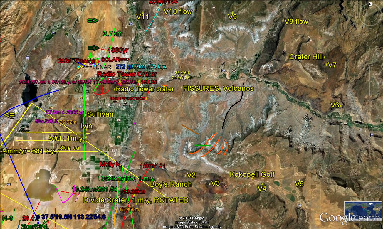
Looking toward the SOUTH, there is a clue that VOLCANOES tell the tale (Follow the Money, the Materialistic detectives admonish):

The VIEW is NOT YET LARGE ENOUGH!

We're beginning to see the relation to the ENTIRE COLORADO PLATEAU, Cp. Notice the polygon formed BY THE LINEARS; Cp has been formed as a MULTI-SIDED FIGURE, with linears for sides. The Mogollom RIM is formed subsequently, as VULCANISM EMERGES from the FISSURES- arising as GRAVITATIONAL SHEAR-ROTATION (by "JERKS"- one each per LINEAR) forms 2-dimensional figures. We are dealing with a figure which becomes rounded as subsequent events (Bays or Protrusions) mis-shape the original POLYGON:


Mt, Trumbull is a VOLCANO along the way:

But the roads require a 4WD vehicle:


Above is Hurricane Mesa- which aligns almost N-S ALONG FRACTURES; this is displaced 20 degrees. whenever the greater distance is viewed by COMPASS, compared to the POSITION at the cliff top:

That this is ANOMALOUS is noted, since the RIVER is DIVERTED 135 degrees from its path above (NORMALLY, rivers MEANDER about 60d-90d at the most):

Further, ANOMALOUS SHEAR is noted at the WHITE DISTURBED AREA:

This can be related to a MUCH LARGER PHENOMENON, since it does NOT MATCH the local fractures; this pertains to the ENTIRE COLORADO PLATEAU:

SEARCHING to the east, to the edge of CP, the CAPULIN VOLCANO (less than 10,000 years last eruption) lies on an extension of CP- a TIT:

EXPANDING the investigation, you see that the VOLCANIC FIELD is much larger than the last Capulin ERUPTION (REMEMBER that INTERVAL TIME is proportional to a MEASURED DIAMETER or DIMENSION):
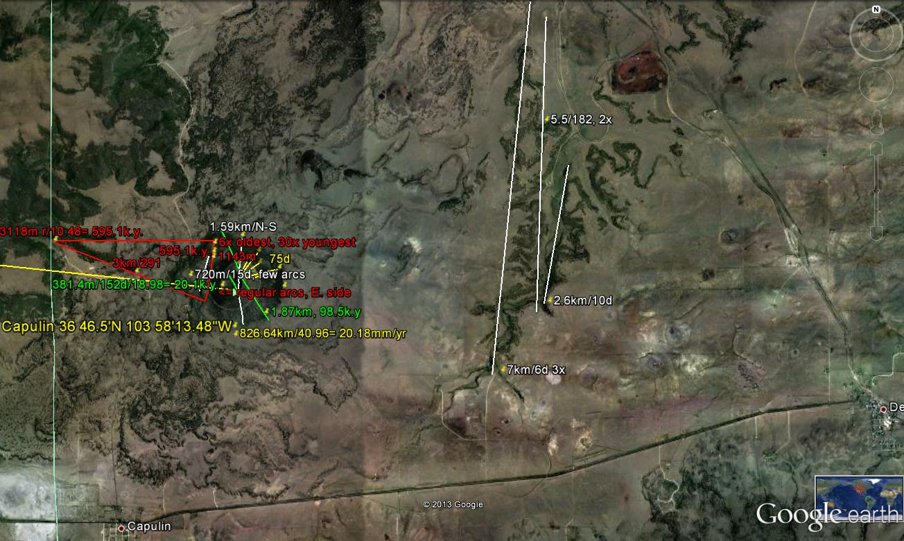
The MEASURED DISTANCE (Google distance tool) is 802 km- which may be used to find EARTH TIDAL RATE for the interval since 41 m.y.- the AGE of the MAJOR EARTH TILT CHANGE, of 41 m.y. Dividing, the rate is: 802/40.96= 19.58 mm/yr- which is a rate found for the NNW corner of the Plateau. 20.48 mm/yr is the normal MAGNITUDE for the NW (N45W) corner of any SEPARATE BLOCK).
FOLLOW the VULCANISM to find the path of CRUSTAL POLYGON FORMATION; this relates to a 20-sided FEATURE- WHICH IS AN APPROXIMATE CIRCLE, but with corners. How I arrive at this figure, since I cannot follow the path with the resulting LARGE SEARCHING ERRORS, is by finding the dimension of one side and relating this distance to that necessary for obtaining a circle with diameter of 800 km (20 x length of a segment, assuming that the other 19 segments have similar lengths- on the average):
This INTERESTING PHENOMENON may be accessed near the LAVERKIN OVERLOOK TRAIL- which has an improved road leading to the VIRGIN RIVER CLIFFS, off hiway 9 to Zion NP:

REVIEW:


To be continued, after FIELD WORK!
No comments:
Post a Comment