NOTE: I have selected CASES which demonstrate the CONCLUSIONS STATED ABOVE, and I have included the ANOMALOUS EXHIBITS- which do not fit. These ANOMALIES have proven to yield much more information about the GRAVITATIONAL INTERFERENCE of Jupiter with the more obvious Venus CYCLES.

Starting with Lake Victoria at the EQUATOR, ellipticity becomes more exaggerated N-S, and finally- upon surpassing 40N, orients E-W. This relationship becomes difficult to evaluate in the southern hemisphere, but appears to apply in Australia. Simultaneously, the TIDAL RATE TRANSITION changes in jerks- near SEPARATION LINEARS-with the deviation in compass degrees x 3 calculating the latitude (e.g. 10d interval x 3= 30N latitude degrees.
Below is the GREENWICH, ENGLAND reference system- exhibiting the ARBITRARY LONGITUDINAL CONVENTION (there is no natural basis for LONGITUDE, as compared to LATITUDE- which relates to CIRCUMFERENTIAL FRACTIONS, e.g. 30 degrees is 1/12th of the earth's 360 total):

Not only has the GEOLOGICAL CULTURE to contend with GRAVITATIONAL LATERAL MOVEMENTS (NULLIFYING the researchers' favorite TOYS: HOTSPOTS, MANTLE PLUMES, and PLATE TECTONICS), but now they have to "put up with" EARTH'S GEOMETRY determining the LOCATION of Lakes and Rivers:
Lake Nicaragua is a lake fitting the same LATITUDINAL FIT (12N) as Asian lakes- which are in a much larger LANDMASS. It exhibits a SEMI-ELLIPTICAL PROFILE, and contains RISES WITHIN A SINK! Further, it is surrounded by a LARGER ELLIPTICAL ARRANGEMENT of small lakes! Strain yourself to incorporate this GEOMETRICAL ARRANGEMENT of features- which are determined by the LATITUDINAL POSITIONING of both rises and sinks according to PLANETARY GRAVITATIONAL INTERPLAY.
Below is Lake Nicaragua- which is located at 12N, or 1/30th of a GLOBAL CIRCLE:


NOTE the CIRCULAR LAKE and the adjoining UPLIFT-ANALEMMA (figure 8), above.
Below, the Antilles in the Caribbean, at 15N latitude (1/24th circle:

 The Great Lakes, USA:
Above "BIG PICTURE" of the Great Lakes shows that the spiraling feature is a COMBINATION of a CIRCULAR SET and a FRAGMENTED Lake Superior. Think of the comparison of the elliptical Colorado Plateau (AXIAL)and the TANGENTIAL BASIN-RANGE IRREGULAR (precessional) feature (explained further,15 photos below).


Above, jerking on a 100 year interval (with significant quakes), and below is a small ROCK SAMPLE-ANALEMMA INSCRIBED:


Angular changes in the direction of ARC convexity indicates that there is a change of TIDAL DIRECTION. Lunar tides have convex west ARCS, with Solar tides showing eastward convexity. The 2 cases below exhibit a LINEAR between the 2 opposing tides. The DIVIDER-LINEAR is a physical entity, shown as continuous (or discontinuous) lines of movement. It separates two ELLIPSES, which may be used to determine the DIAMETER RATIO. If 1.62, this is created by Venus, and if 2.5, it refers to Jupiter:

Black Sea ABOVE, and Gulf of Mexico BELOW yield valuable CONFIRMATION:

The GREAT SALT LAKE lies at an ANOMALOUS POSITION- being influenced by the 40N termination of the EQUATORIAL BULGE. I will analyze this further- scroll down:

Ignore all DOGMA INDOCTRINATED by your CLASSIFICATION-BASED CULTURE, and notice that all the LANDMASSES exhibit ARCUATE river valleys, rising ELLIPTICAL chains of hills-mountains, and CONTINENT-WIDE ROTATIONS:

The GREAT SALT LAKE, UT:

There is ORDER in this IRREGULAR SALT PAN; it is ENLARGING with time, so that the CURVATURE has been modified by SUBSEQUENT EVENTS! One must look to the AVERAGE BETWEEN protruding tits and receding bays. This is not a JUGGLE FACTOR- the smaller arcs modify the OLDER LARGER CURVILINEARS!

Australia- being mainly a desert- exhibits an almost DRY LAKE; notice the LONGITUDINAL CONFIRMATION (135E- a multiple of 45 degrees, in addition to the LATITUDINAL FRACTIONS):

Lake Torrens lies at 30S:

UN-NAMED LAKES:

At the coast:


There is a MAJOR ROTATION at the Great Lakes, USA, as is obvious with the CIRCULAR EXHIBIT of the lakes; they are rotating CW (sinking), and the FULCRUM is approximately as shown:

RE-CALCULATING:

A CLUE to the SPIRALING LAKE SUPERIOR is found from its several BASINS- SIMILAR to those exhibited in the BASIN and RANGE PROVINCE of the USA. It EXHIBITS 12-13 BASINS-which are correlated with RHYOLITIC EXTRUSIONS at the OR-NV-UT BORDER. This feature is older, so that the number of basins has to be determined from the literature. Possibly the MARITIME PEOPLE will have this information:

LINEARS separating ARC REVERSAL yield a start to finding the STEP FUNCTION of the locations of the Great Lakes, USA:

Sometimes the DATA are so ENLARGED that one CANNOT SEE THE FOREST, FOR THE TREES! After working many cases, I found that CIRCULAR SINKS were divided into 30 degree SEGMENTS- usually on the EAST SIDE! Returning to the Great Lakes, this was indicated by the LAKES' LOCATIONS. There is a small error of 2 degrees on the north side, but I am used to having a NOT QUITE PERFECT FIT!

Above SEGMENTATION of CIRCULAR FEATURES is so regular, that I can now use it to determine the PROGRESSION of TIDAL RATES on the east side of all ELLIPSES, e.g. the Gulf of Mexico. The rate is not a standard 10.24 mm/year, but has a MAGNITUDE CHANGING EACH 30 DEGREES, in "JERKS"!

JERKS are commonly shown for CIRCULAR FEATURES, and you must search for the EXHIBITING LINEARS- which are "true" straight lines, and NOT CURVILINEARS!
JERKS are defined by engineers as: d(dv/dt= acceleration)/dt= 2nd derivitive of velocity.
d("jerk")/dt= 2nd derivitive of acceleration= CHATTER. This is easily noticed, when you unevenly accelerate your auto. Your head jerks back-and-forth, according to your action on the foot peddle. This is my DEFINITION, not used by anyone else, but you can see the RELATIONSHIP below, as MOUNDS which have been compressed and shoved in ELLIPTICAL PATTERNS upwardly (each mound results from a jerk of gravitational movement- alternatively downwardly):

How about Asian Lakes?

THE "S" shaped ANALEMMA PORTION shouldn't escape you, and the bottom portion ANGLE SHIFT is 15 degrees (which multiplied by 3 yields the 45N latitude.
This CONFIRMS that ISOLATED LAKES' location- latitudinal- is determined by EARTH GEOMETRY. This indicates that EARTH DEVELOPS SINKS, whenever a circular fraction of the total circumference is FULL MOON-INFLUENCED by expanding diameter and opening spaces- such as grabens, circular sinks, and DOWNWARD-SPIRALING ROTATIONS.
There is no significance to LONGITUDINAL ANGULAR SHIFTS, since Greenwich is arbitrary (they "aced-out" the French- who wanted 400 degree circles and a location in Paris). But IT TURNS OUT that there is a MERIDINAL RELATION, just that it is NOT REFERENCED to GREENWICH!

I HAVE RE-WORKED THIS CASE, since the orientation and the analemma are oriented N-S (this is north of the equatorial bulge, at 40N). The main reason for this deviation from the average (from CASE HISTORIES) MUST BE due to the CRITICAL LONGITUDE of 50E. I have yet to believe this, and will incorporate other cases:

The Caspian Sea lies at a CRITICAL LOCATION: at the INFLECTION of the EURASIAN reverse "S". This infers that the double-continent is SINKING, but it appears to me to be RISING (while the forward "S" of the Caspian Sea-SINK indicates RISING? This further anomaly is explored below:

There is an ELLIPSE of smaller lakes- surrounding the ANOMALOUS CASPIAN SEA; this is similar to elliptical arrangements of RISES, about Zion NP and the Checkerboard Mesa. Others include the San Juan Islands, where THRUSTING has instituted COMPRESSION (similar to many observed MIMA MOUNDS and their counterparts in the Sand Mountain, St. George, Utah, where the mounds erode at the flanks and harden for the remaining parts- ROTATIONAL SHEARING).

Added is the DISCONTINUOUS SMALL LAKE ELLIPSE; this shows that both JUPITER and VENUS are in CONJUNCTION at this CRITICAL LATITUDE, LONGITUDE!

KARABOGAS (Black region, in Turk) EVAPORITIC BASIN is an interesting anomaly: it is so hot there, that water continues to INFLOW and EVAPORATE- leaving the lake to concentrate salts-minerals:

Karabogas is a source of salt for humans, but it has eliminated most cloride, and replaced it with sulfate- which is a new source of sulphur as organic life chemically-reduces it at the expense of carbon compounds, which are ingested. The feature not solved is the unusual concentration of Magnesium- which is usually about 1/10th calcium. In this bay, Mg/Ca= 2 or more. Since this is GRAVITATIONAL ANOMALY, and dee-, below sea level- Mg derives from previously-buried MgCO3 or MgSO4. The solution of this rarity will shed light on the CHEMICAL PATH REVERSAL for the sinking basin.

The SOUTH POLE provides a start in understanding the geometry of the Caspian Sea 40N 50E ANOMALY. It is due south of the "TIT" on the west side of the sea (all roads lead to Rome, since any due south Meridian will terminate at the south pole):
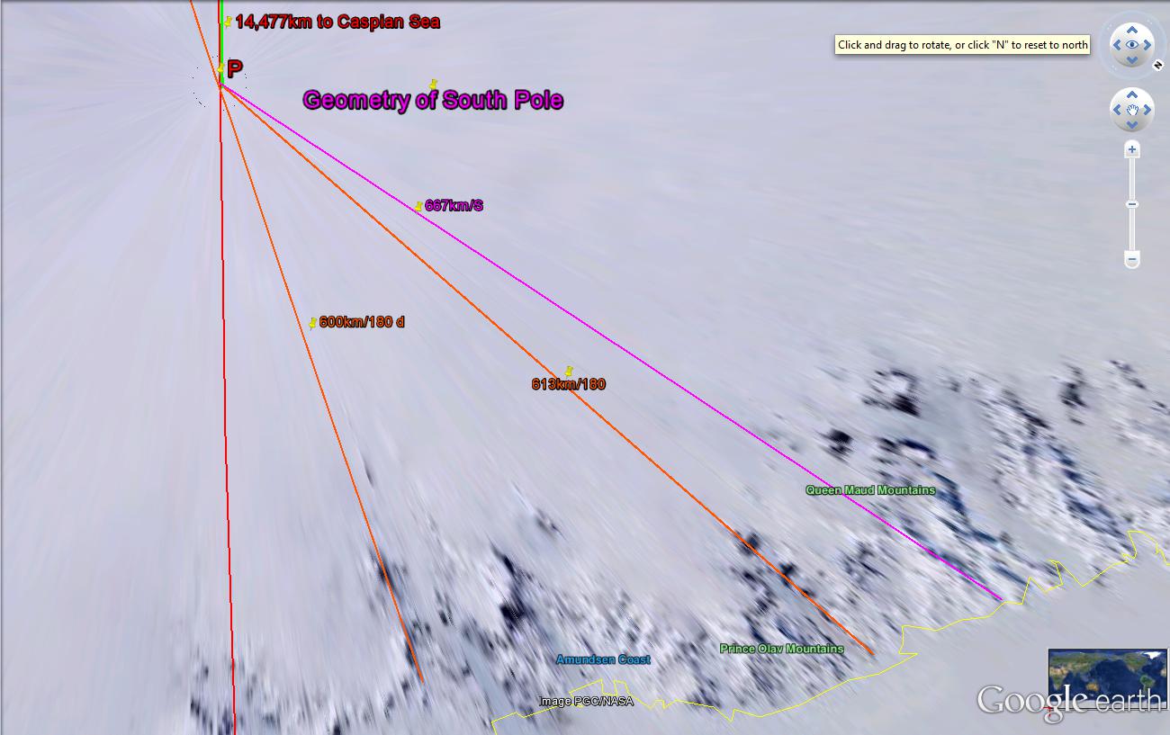
There are measured some CRITICAL NUMBERS (RATES) and we have to fit this in with the VENUS' GRAVITATIONAL INFLUENCE. There is the 243 year REPETITION of the Venus pattern, and this divided by the EARTH'S is 1.6255 (our old friendly ENIGMA). The next CORRELATION to pursue is the similarity of 243 years to 24,300 years: a 1/100th HARMONIC of the MILANKOVITCH PRECESSIONAL CYCLE (the "ragged" entity, developing TILTED-IRREGULAR Basin and Range features). Not only is DV (Death Valley, on the same Meridian as Great Bear) a tilting basin, but the Great Bear Lake is also irregular, cross-patterned, and "ragged". All of these clues are suggesting that Venus is next in IMPORTANCE to the MOON:

We now have another TRAPEZOID: 40N 50E to an ANOMALY at the White Sea (66N latitude), Great Bear: 66N 116W to Death Valley and the diagonal lines connecting these locations:
WHITE SEA is the significant anomaly along the CASPIAN SEA MERIDIAN; it exhibits a reverse"S", indicating SINKING (again the reverse of that expected):


This is put on hold, until the data elsewhere tells me the ANSWER!

A clue to the LARGE LAKES/small lakes DICHOTOMY is shown for the lake exhibit near the SUTTER BUTTES-GEYSERS GEOTHERMAL ANOMALY:

The "larger picture" exhibits the smaller lakes along the 45N latitude in Eurasia, and they become progressively smaller to the east! This indicates that RECENT TIME, or EVENTS, is to the east (CCW or RISE to the east prohibits further SINKS), and I will appraise this after incorporating as many cases as I can find (that are large enough to be significant). ALL EURASIAN LARGER LAKES are located along a CONSTANT LATITUDE LINE (in this case- along the 45N latitude, yielding the clue that 180/45= 4 is an IMPORTANT RATIO that must be searched in the MEASURED PLANETARY DATA), so that there is NO LATERAL AGE CALCULATION POSSIBLE:

Proceeding along a constant LATITUDE LINE entails observing a circle or RING AROUND EARTH: an ARC of NO LATERAL CURVATURE (vertical only), so that for this case TIME MAY NOT BE CALCULATED FROM CURVATURE! I escape this circumstance, above, by finding that there are shear lines along a curved path. East Asia is moving faster (TIDALLY) than GRAVITATION CAN FORM LAKES-SINKS!
Let's revert to a smaller-younger feature to the west: the ARAL SEA. As I have found for rising MOUNDS in ELLIPTICAL PATTERNS, there should be EQUIVALENT SINKS in similar patterns:

Aral sink is mainly ROUNDED, and exhibits a smaller diameter-AGE. It has not yet progressed to a FULL-FLEDGED ANALEMMA (although the smaller PRECESSIONAL EXHIBIT exists at the lower part of the photo). Similar to that found at the WARM SPRINGS, NV State Park, there occurs a rise (offsetting sinking) which develops into a Basin and Range configuration. This is accompanied by HEAT, PRODUCING VULCANISM after sufficient time. The reader can calculate the TIME INTERVAL, by taking a continuous arc/30.72 km/m.y. for the EXACT SW corner. This will be greater than the NORMAL MILANKOVITCH 25 k.y. time interval, since VULCANISM DEVELOPS within a m.y. cycle.
SEE WARM SPRINGS STATE PARK, NV BELOW:

I perceive that there is a LONG-TERM CYCLE of 100s, of at least 123 million years (3 x the 41 m.y. polar CYCLICAL tilt change OF 3.6 DEGREES- 410 km) in which the FULL MOON CYCLE introduces expansion of the diameter of the earth, with subsequent expansion and GRABENS' OPENINGS: SPIRALING DEPRESSIONS-SINKS.
How about the Mediterranean It is near this arrangement of Lakes, but it is so large (old- three 41m.y. POLAR ANGLE SHIFTS or 123 m.y.) that it has developed many TITS, BAYS, and coastal FEATURES which must be "averaged out" by SMOOTHING!

Again, the "S" is reversed- indicating that there is CW ROTATION-SINKING.
Egypt and the QATTARA DEPRESSION (a sabkha dry lake) lies on a 15N latitude line also:

PROCEEDING with our own continent, view the GREAT BEAR LAKE, in Canada:
 This FEATURE EXISTS at 66N 120W, and although the Longitude is a MULTIPLE of 30d (1/3 of a circle), the latitude of 66N is NOT!
Great Bear Lake, at the JUPITER-VENUS CONJUNCTION:

There is a LONGITUDINAL ARRANGEMENT of the ANOMALIES, created by the CONJUNCTION of events established by GRAVITATIONAL AUGMENTATION of the MAJOR SOLAR SYSTEM MASSES (possibly for all solar bodies, but Jupiter has 2.5 x the mass of all the others- NOT INCLUDING SUN). I have to correct preceding work, which assumed that the Moon and Venus were the MAJOR PLAYERS! Now we see that the UNEXPLAINED ANOMALIES (ICELAND, MARIANAS TRENCH, GREAT BEAR, CONTINENTAL SEPARATION) result from CONJUNCTION or OPPOSITION of the SOLAR MASSES!
A clue to the importance of the Great Bear Lake is found at Death Valley- where the SINK lies directly south of Great Bear (on the same MERIDIAN):

UN-LINED BELOW:

Notice that the POLAR TILT CHANGE CYCLE: 41 (40.96, by the BINARY THEOREM) m.y. and its HARMONICS of multiples of 41 k.y. are exhibited. I suspect that PLANET VENUS is involved, and we will have to find a way to confirm this important GRAVITATIONAL LATERAL INFLUENCE.

Death Valley exhibits an ANOMALOUS CYCLE- the SINK SHOWS a REVERSAL of angular rotation; this in conjunction with the FAULT LINE ANGULAR SHIFT(that I noticed on my field trips) indicates that a GRAVITATIONAL INFLUENCE other than the regular MOON-SUN CYCLES is involved!
The Basin and Range valleys are spaced 1 m.y. apart, at the start. With time they proceed to enlarge, or widen E-W. Considering that they have not enlarged at this 2 m.y. ELTANIN EVENT, they average a rotation of 5 degrees/m.y. EXCEPT FOR ANOMALOUS DEATH VALLEY! This valley is ORIENTED DIFFERENTLY, and the hints are that the VENUS TRANSITS cause the disruption! It has reversed by an estimated 3.6 degrees, and this is the amount associated with 400+km, or the 41m.y. PERIODIC SHIFT of the POLES! I will proceed to determine whether VENUS is ALWAYS ASSOCIATED with the PERIODIC EQUINOXIAL SHIFT.
A CAVEAT IN ADVANCE: Venus lies between the earth and the sun; it cannot GRAVITATIONALLY-EXPAND EARTH as does the Moon, Jupiter, and the other planets. It can only attract earth, thereby SHRINK-CREATING THRUST FAULTING with its normal interaction. I do not expect that Venus can create GREAT SINKS-such as Death Valley. There has to be another mechanism, besides LATERAL EXPANSION! REVERSAL of normal VALLEY ROTATION, as shown above, must depend upon the RETROGRADE ORBIT of Venus. It fits that Venus, early on, has gravitationaly attracted mass (earth's crust portions at the Great Grand Canyon Unconformity)- flung from earth by the 1.024b.y. GRAVITATIONAL "SHAVING" of the crust (FRAGMENTATION). This has been repeated later: the archipelagoes of Indonesia, the West Indies, down to the FLORIDA KEYS are composed of fragments. In the process, Venus became retrograde (reverse orbit compared to other planets), incorpoated earth mass (there are NO MOONS!), and exhibited a PECULIAR ORBIT about the SUN.
The NEXT HINT exists at the MOLUCCAS- 2/3rds of the earth distant- where the longitude is 120E. The globe is relating that there is a relation of thirds, and that the N-S meridians are in a TIMED order. This can be explored by referring to those PROMINENT MERIDIANS: the WASATCH LINE and the meridian through the New Madrid Mississippi River location.
First, look at the "S" or incipient ANALEMMA-SWASTIKA for the island of Celebes-Sulawesi. Notice the LINEARS- STRAIGHT LINES of no curvature (reversal of CURVATURE BETWEEN islands north and south of the Equator). This circumstance is repeated for the entire GLOBE, for rotations- regardless of scale:

I live near the Wasatch line- Hurrricane fault- which traces IRREGULARLY along the portion from Hurricane to Salt Lake City:


Above trace is NOT HELPFUL, so look at the N-S TRACE of the CHICXULUB to Mississippi River:

BINGO! Above MERIDIAN and Latitude line (30N) both conform to the FRACTIONAL CIRCULAR EXHIBITS! (of the earth's 360 degree or 40,000 km CIRCUMFERENCE). This will yield valuable information about the LONGITUDINAL INFLUENCE, so long as there is a DIVIDER NEAR the GREENWICH ZERO north line. I visited this location in London long ago, carefully straddling the BRONZE SLOT. We still have to determine why the Great Bear Lake (can I bear it?) and the Caspian Sea are ANOMALOUS, in terms of their ORIENTATION!

FURTHER HINTS are shown for the SOLUTION of SINKING-RISING FEATURES at FRACTIONAL GLOBE DIVISIONS, in the Indonesian ARCHIPELAGO above- where the ANALEMMAS display ROTATIONS at CRITICAL LATITUDES. This one is located just south of the EQUATOR- SIMILAR TO LAKE VICTORIA (BOTH in the southern hemisphere and both displaying the CIRCLES ADJACENT to the EQUATOR!). This one is oriented E-W, as have been others- EXCEPT CASPIAN SEA, for latitudes less than 40N.
OBSERVATIONS:
1. INLAND LAKES occur when they are land-locked- indicating that TIME HAS NOT BEEN SUFFICIENT TO ALLOW EROSION to break down the MILANKOVITCH SCARPS-UPLIFTS;
2. N-S ORIENTATIONS occur for locations where there occurs a DIVIDING LINEAR;
3. N-S DIVIDERS OCCUR as boundaries between AXIAL (41 k.y. multiples) and PRECESSIONAL CYCLES (approximate 25 k.y. multiples, being a variable within these time periods); and,
4. The Great Bear lies well north of the monthly movement of the MOON- yearly EQUINOCTIAL OSCILLATIONS, but within the ECCENTRIC VENUS ORBIT influence.
VENUS has no moons, and has early-on gravitationally attracted EARTH CRUST thrown off during the 1.024b.y. GRAND CANYON GREAT UNCONFORMITY (to be proven!)

A COMPARISON with the sun indicates a mere IRRITANT- a fly-in-the ointment, but the ORBITAL RATIO of days/year to EARTH'S: 1.62 KEEPS "CROPPING UP" in my analyses!
The track of
RETROGRADE VENUS crosses the position of Great Bear Lake, and this is confirmation
that Venus is able to GRAVITATIONALLY-SHOVE the EARTH’S CRUST LATERALLY. Since
there is an ANALEMMA, this infers that another MAJOR MASS is still offsetting whatever
happens OCCASIONALLY. LIKELY the MOON
and the sun have residual influence, even though they are only on the horizon
(Great Bear is north of the MONTHLY and YEARLY BOUNDARIES of the regular travel of SUN-MOON ORBITS.
The persistence of ARCUATE FEATURES in the time domain of MILANKOVITCH’S AXIAL,
ELLIPTICAL, and PRECESSIONAL CYCLES (multiples of 25, 41, and 100 k.y.)
indicate that they are operating, while being over-impressed with the VENUS RETROGRADE CYCLES.
Great Slave performs similarly to Great Bear: it lies on the 60N Latitude, has younger MILANKOVITCH CYCLES, has been recently revised, displays an ANALEMMA, and exhibits several ARCUATE SHEARING ROTATIONS. Its LONGITUDE has as yet no IDENTIFIABLE RELATION, and requires more work to CATEGORIZE IT (sounds like geological DOUBLE-SPEAK):

Our own continent has escaped the attention of EARTH SCIENTISTS; it exhibits INLAND LAKES along the 45N and 60N latitudes. I am still working on the LONGITUDINAL PERIODICITY:
The Great Slave Lake fits within a LARGER ANALYSIS:

Larger yet, for the NE CORNER OF NA:

And looking at the St. Lawrence SEAWAY, in particular, we see that there is a regularity to the positioning of the GREAT LAKES, when all scientists thought that they were simply created by the ICE AGE DEPRESSION. This DEPRESSION (SINKING) accompanied the ICE MOUNTAINS, but the INCIPIENCE was due to SPIRALING SINK CREATION- brought about by the PERIODIC FULL MOON CYCLES and their HARMONICS, with EARTH DIAMETER EXPANSION and CONSEQUENT EXTENSION of the crust- causing SPIRALING DEPRESSIONS- the opposite of MOUNDS or MOUNTAINS:

How about South America?

The Amazon Basin is the GREATEST LAKE in the entire globe; it is surrounded by 12 ARCUATE FEATURES (I have drawn 6 for half of it), and exhibits the usual ANALEMMA, for a sinking basin- a reverse "S". I will not analyze further, but interested scientists should "PORE OVER" the continent- to discover why it has filled the basin with vegetation, rather than open water. This is the REVERSE of Africa, where there is exhibited a dessicating desert, and where the Lakes are concentrated about the GREAT AFRICAN RIFT!

There is CONSIDERABLE SUBJECTIVITY above, but the white LINEAR divides the 2 ARCS, according to the INFLECTION POINTS. Surprisingly, there is a RISING PORTION (FORWARD "S") which contains the SINKING FEATURE, and this may account for the INCREASING ENCROACHMENT of the Sahara desert. The colors are backwards from my usual BLUE SINKING and RED RISING, but the positions relatively are correct!
Reference to the MAR may shed light on the SHEARING ROTATIONS, yielding insight on the EARTH TIDAL MOVEMENT RATES. This is shown for 10N Latitude, where there is ACCELERATED MOVEMENT ALONG the transforms ABOVE AND BELOW THE MAR SHEAR ZONE:

I will select a MAR PORTION where there is relative movement along TRANSFORMS. RATIOS of the spread should determine the TIDAL RATES' RATIOS, e.g. 20.48mm/yr at the NW corner/16.24 at the S boundary= 1.26:

CLOSE but no BANANA! The various ratios are nearer 1.6 than anything else! This finding emphasizes that Venus and its 1.62 orbit ratio is the most PREVALENT of the GRAVITATIONAL RATIOS ivestigated!

Checking CLOSER to the EQUATOR:
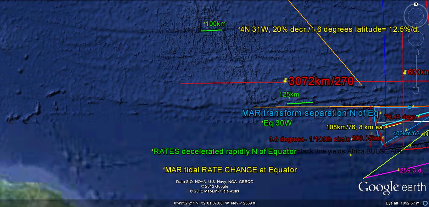
You can see how CRITICAL is the ARCUATE PLACEMENT CENTER; one degree of Latitude, or on the COMPASS ROSE, makes errors up to 12.5% in the TIDAL RATE. This makes it CRITICAL that the ARCUATE CENTER of calculation be EXACTLY at the QUADRANT CORNERS or at CARDINAL POINTS! I have not yet solved the SE CRUSTAL BLOCK RATES; they vary somewhat over the NE to SE locations!
Photo below shows how the EASTERN HALF of a CIRCULAR FEATURE has an IRREGULAR CONFIGURATION; I still have to find a model which demonstrates the TRIGONOMETRIC PRESENTATION of the EASTERN TIDAL RATE MOVEMENTS (I have used 10.24mm/yr but is is SUSPECT, and probably varies from 16.24 S, to 10.24E, to 17.48mm/yr N, with gradual changes in the interim). The average would be 43.96/3= 14.65mm/yr- a 30% error!

Below is the SEAWATER TIDAL VARIATION- which is TRIGONOMETRY-RELATED (sine functions), and it is the basis for EARTH TIDES, as well as atmospheric tides:

The ANALEMMA DEVELOPMENT-which is the basis for lateral faulting for the entire CRUST- IS SHOWN BELOW:

I have replaced the below diagram of the TIDAL RATES with a more accurate one, and it will be published later SCROLL down:

Although the sun is constantly GRAVITATIONALLY-ATTRACTING the earth, its LATERAL SHIFTING is interfered with the moon and planets. The Moon, although smaller, is closer and creates the greatest slowing FRICTION. Rather than using more absolute PHYSICAL PROPERTIES, RATIOS allow us to determine the RELATIVE TIDAL FRICTION or RATES:
The Metaphysics of Jupiter and the GASEOUS GIANTS:
After 7 years of analysis of the influence of GRAVITATIONAL LATERAL SHEARING, I am going to indulge my non-rational “gut feelings“.
1. Similarly to the ASTEROID BELT being a FORBIDDEN ZONE, where there exists a DISCONTINUITY, there are locations-times where the EARTH’S CRUST exhibits GRAVITATIONAL FRAGMENTATION. These are mostly in the dim past, but the Florida Keys is a young feature, and there exist others younger- Cape Hatteras along a N-S linear being less than 1 million years of age.
2. The asteroids are arranged in a zone between Jupiter and the Rocky Planets, where they replace a once-present major planet. This X planet has disintegrated, under the SHEARING FORCES of the largest solar planet Jupiter.
3. This zone of asteroids acts as a SCREEN- where the discontinuity there NULLIFIES the lateral gravitational influence of the OUTER giants. Although the masses in this outer region follow the rules of VERTICAL ATTRACTION, they appear NOT to follow the LATERAL RULES FOUND FROM CASE HISTORIES.
4. It appears that gravitation operates in waves- where periodically, in TIME AND SPACE, there occur FORBIDDEN ZONES. This applies to LINEARS on the EARTH’S CRUST, where you may not calculate time interval from CURVILINEARS, but where a LINEAR OCCURS instead.
5. It also appears that the Caspian Sea is such a DIVIDER, where there is a discontinuity in the shape of the reverse “S” across the Eurasian landmass, and where the regions to the east and west imply a DISCONTINUITY in the RISING-SINKING RELATION.
Jupiter is HIDING BEHIND the MOON!
This largest planet has a 11.86 earth year ORBIT AROUND the SUN; when in CONJUNCTION (aligned outside earth and sun), it attracts earth oppositely or EXPANDS EARTH (BULGING). When it occupies space with the sun in the middle, it CONTRACTS EARTH- causing COMPRESSION (SHRINKING). Since this happens on about the same 1:12 ratio as the moon (yearly, as opposed to monthly for the moon), it is difficult to separate the effects. But the MAGNITUDE is greater for Jupiter, since mass/separation (m/d) is almost 16 times as much. NOTE THAT m/d squared is Newton's MATHEMATICAL RELATIONSHIP! This effect is continually changing, but the most OBVIOUS EFFECT is that of creating SINKS whenever Jupiter opposes the sun. I expect that the "JERKS" occur as the Moon monthly augments or 2 weeks later offsets Jupiter, in vertically attracting earth! RISING- occurs, at inferior conjunction (Jupiter locates between sun and earth). This becomes noticeable whenever the CONTRAST OCCURS near sea level, or at LARGE LAKES- such as the Caspian Sea (notice the 6 small lakes around the perimeter). An excellent example is exhibited at the Puget Sound:

The DUO of a sinking Saratoga Passage and a rising Camano Island exists in the Puget Sound-Island Archipelago. This is duplicated in many places in the world, and I will determine whether it occurs ONLY with OBVIOUS ANOMALIES- such as the San Juan Islands ELLIPTICAL ARRANGEMENT of islands. The separation of individual islands should be due to the "jerks" between movements of both the Moon and Jupiter from one 30 degree crustal rotation to another about a FULCRUM. This must be happening on both the monthly and the yearly scale (developing over many repetitions):

THE 12-13 RISES are shown for the San Juan Islands- which fortunately the Americans rescued from the "PIG WAR" with the British-Canadians!

Looking more closely, where I have done 14 years of HIKING and field work, at Whidbey Island we find that another MYSTERY HAS BEEN SOLVED! The small lakes surrounding Holmes Harbor (a lobe formed by the later ICE AGE PROTRUSIONS to the south) are in an ELLIPTICAL ARRANGEMENT, with indications that the RATIO of 2.5 is exhibited! This is the ELLIPTICAL/AXIAL ratio found by MILANKOVITCH, and which is the less common ratio calculated from OUTCROPS. Usually I find the ratio 1.6 for ARCUATE DIAMETERS of much older outcrops. Proceeding on the idea that we are finding the GRAVITATIONAL "JERKING" due to the planet JUPITER, we now have a method of sorting Jupiter from the MOON- which is STILL MORE forceful! If TRUE, we can merely calculate the ratio of observed features and their dimensions across the DIVIDER, and we can separate these two entities:

I'll find another YOUNG FEATURE (preferably from the Pleistocene) which we can use to test this finding: Cape Hatteras, or Delaware Bay N-S movements.

My AGE estimated was incorrect! I'll try the Delaware Bay:

MAGNIFYING:

Notice the REVERSE "S" for the INLET to the east; it indicates SINKING- which should be correct, since they grow CRANBERRIES there!
What have we proved? This analysis shows that the direction of ROTATION is an indicator of not only SINKING-RISING, but that the INFLUENCE of Jupiter determines the placement of these SINKING "JERKS"! The movement is NOT CONTINUOUS, but evidently occurs whenever the MOON-JUPITER CYCLES REINFORCE each other to produce earth diameter expansion, whenever the planet occurs at opposition.
The "big PICTURE" reveals another VITAL DISCOVERY. It shows that the CONTINENTAL SHELVES-CANYONS are also GEOMETRICALLY-ARRANGED (each 40km and 15 degrees angles of SEPARATION)! Will wonders never cease?

The REGULARITY of the CANYON ORIENTATION indicates that they orient at angles which change with NORTHWARD PROGRESSION. This is determined by the CYCLE ALTERNATION from AXIAL to PRECESSIONAL (40 to 25 m.y. harmonics of Milankovitch's 41 to 25 k.y., with 2% error- see total 239/6= 40-):

Different ANGULAR INTERVALS are examined below, and the most useful one is the 15 degree interval- showing the CANYON SEPARATION:

I'll revert to the one I can hike and see for myself- Whidbey's Holmes Harbor, which exhibits MIMA MOUNDS and the UPLIFTED ELLIPSE with TERRACES:

Magnifying the SE corner of the Harbor Golf MIMA MOUNDS:


The CALCULATED AGE requires some investigation; I have previously found an exotic rock- carried by GLACIATION- adjacent to a local mound. The time of the N-S GLACIATION is greater than 15,625 years, by the BINARY THEOREM; above calculated AGE fits this evaluation.


As usual, there are 6 in a HALF SET:

The ELLIPSE lies along the DIVIDER of the LARGER LAKE ELLIPSE! This yields clues about the GRAVITATIONAL PHYSICS CONNECTION between the Jupiter ANALEMMA of small lakes and the "popup" of the mounds. Again, this represents a RISE within a SINK of 12 lakes- both of which are DISCONTINUOUS in TIME AND SPACE! They are NOT CONTINUOUSLY FORMED along an arc, but are formed by"JERKS"!

Puget Sound may now be recognized as GRAVITATIONAL FRAGMENTATION:

The IDENTIFYING CHARACTERISTIC, beside the 2.5 ratio, is the INDENT (in this case at Double Bluff):

I always wondered how it was that the bluff PROTRUDED into the Admiralty Passage, and yet remained ahead of EROSION! It is hardened by the Jupiter COMPRESSIONAL CYCLE (half of the 12 year orbit, the other half is a sinking effect):

Mass, referenced to total NON-SUN solar bodies: 2.5 x all other;


Notice that the east side is composed of 6 separate arcs, representing half of the MOON CYCLES/YEAR (requiring many cycles to develop the volcano crater and ANALEMMA). This model will require a TRIGONOMETRIC MODIFICATION to the simplified 10.24mm/yr rate used previously.


I have reworked this FEATURE, USING ANOTHER COMPUTER, since this has the potential to form the BASIS for EARTH TIDES in the EASTERN QUADRANT. Above is shown the crater subdivided by 30 degree segments. Notice that they are easily identified, by merely drawing a line from shear orientations and small bays! This relates that twelfths of the GLOBAL CIRCUMFERENCE are NATURAL GRAVITATIONAL DIVIDERS ("jerks"). This was hinted with the CASPIAN SEA ANOMALY.

Photo above indicates that there have been many ERUPTIONS: from as far back as 189 k.y. (192, considering the BINARY THEOREM, and my 5% errors). The latest I can find is only a few thousand years AGE.
This finding indicated that I should analyze 30 degree segments of the ARCUATE WEST COAST, with the FULCRUM of the Mississippi River BEND (New Madrid infamous 1812 super-quake):

This analysis confirms that the segment from Santa Barbara, CA to the Columbia River outlet (30 degrees by the compass at the river bend) exhibits measurements which have RATIOS appropriate to those found from the TRIGONOMETRIC SINE VALUES shown on my DIAGRAM. This is 27.72mm/yr at due W: 27.72- .5 x (27.72-20.48)= 24.6mm/yr, for the 30 degree interval- average!

I expected that the segment would terminate at the Olympic Mountains FULCRUM, but you can see that the rotation changes (INFLECTION) at the Columbia River. Let's look at the NEXT 30 DEGREE SEGMENT:

The segments separated by 30 degrees are shown in white; the ratios of segment length are appropriate for those for the shown magnitudes. These are NOT for the APPROPRIATE DIRECTIONS, but show that the segments indicate ANOMALOUS ROTATIONS. These will be explored for other continents, to determine whether they "FIT" GEOMETRICALLY-DETERMINED POSITIONS.
Two more rotations are shown below, in 30 degree segments:

The WESTERN-MOST SEGMENTS exhibit INDENTATIONS (bays and inflections), while the NW to NE show PROTRUSIONS. Evidently, this is due to the WESTERN-MOVING TIDES from Mexico to Vancouver Island. Alaska is a "TIT"- moving NW-erly since 192 m.y. previous!
A NOTE ABOUT ATMOSPHERIC GRAVITATIONAL TIDES:
The lower atmosphere, below 10,000 meters effects almost all of the changing weather- such as storms, heat and moisture. This portion is readily viewed in EARTH SATELLITE PHOTOS. These are available from NASA, as hemisphere photos each 3 hours during sunlight. Below is one which allows predictions to be made:

It is difficult to see the "BIG PICTURE" from the ground surface, but occasionally I am lucky:

PVM (Pine Valley Mtn,) can be viewed from the volcano behind my house; this relates that there will be a MAJOR WEATHER CHANGE before the next NEW MOON- Jan 2013! It was INDEED- the coldest 2 weeks, since I arrived to experience it, but I had it reversed at first appraisal. The key was the fact that the RISING CELL was to the east; the one to come was the SINKING-CW COLD AIR MASS- to the west:

See the ATMOSPHERIC TIDES EXHIBIT from NASA, below:


This photo, just before WINTER SOLSTICE, exhibits an ELLIPSE FORMING (Bermuda High to the Caribbean-Cuba western portion). It exhibits an ANALEMMA for the ellipse and the SW portion of the USA. Strong winds AHEAD!
The GREAT LAKES, USA show the LONG-TERM influence of Jupiter:

Expanding:

Above analysis of the GREAT LAKES SURROUNDINGS show that both Venus (1.6 ratio) and Jupiter (2.5 ratio) are involved in the SMALL LAKE PLACEMENT!
There is a PREDICTION associated with the Meridian west of the Great Lakes! The first warning occurred last year, with the "Clintonville, WI bangs"! This environment, with its GRAVITATIONAL FRAGMENTATION is shown in the below analysis:

The FIGURE 8 ANALEMMA is the initial clue to the PREDICTION!:

FRAGMENTATION may operate similarly with all planets. We'll try the VOLCANIC ISLANDS in the Antilles, since there is not the complication of LARGE LAND MASSES:

Analyzing for DIFFERENTIAL RATES- to find the FULCRUM, allows an inspection of the GRAVITATIONAL INFLUENCE of both Jupiter and Venus:

Both planets influence the EASTWARD PROGRESSION of the Antilles; in this case, the feature is a RISING ISLAND SET and a SINKING Caribbean to the west. It becomes obvious that the TIDAL RATE is greater to the west, compared to the east, since POTENTIAL is being converted to KINETIC ENERGY (GRAVITATIONALLY SPEAKING).
We will review Great Bear Lake before proceeding:

The combination of ECCENTRIC RETROGRADE VENUS (reverse orbit) and Jupiter’s GRAVITATIONAL PULL creates an INDENT in the otherwise ELLIPTICAL ARRANGEMENT of Lakes. Notice that there is in effect a WOBBLE, probably in the earth’s POLES. This might be solved mathematically, for the combination of LOXODROME and TRIGONOMETRIC paths. I am not up to this, but will reflect how it can be handled pragmatically (pictorially or graphically). A new finding is shown with the “tit”- which is formed in reaction to the SINKING of the LAKE, as a RISE on the opposing side of the large BEAR LAKE. We will check to find whether this is a GENERALITY- occurring for all such PROTRUSIONS, regardless of scale or size, or TIME INTERVAL.

This ELLIPTICAL ARRANGEMENT has produced a TRIANGULAR-SHAPED LAKE! Notice it at the southern border of the blue set of "jerks". It is measured below, for age and location:

It is surrounded by the WOBBLING ARRANGEMENT of sheared outcrops- possibly creeks. Analyzing further:

These are considered GLACIAL POTHOLES by geologists, and this is another LATERAL GRAVITATIONAL MOVEMENT SET. After all, WATER WAVES or ice moving downhill is a translation of vertically-instigated movement into side-ways motion!

A simple case is that of MARTINIQUE ISLAND- which erupted as a RHYOLITIC EXPLOSION in 1902. Everyone was incinerated, except a prisoner underground- who lived to "tell the tale":

Literature relates that there are 8 vents; I find only 4, but they are categorized as "TITS", which we now know are any RISING APPENDAGE:

We will review Great Bear Lake before proceeding:
A NEW REVELATION is shown in the SIMULTANEOUS DEVELOPMENT of a "TIT" and an INDENT in the otherwise ELLIPTICAL ARRANGEMENT of small lakes surrounding the ANOMALOUS GREAT BEAR LAKE. This will be helpful in understanding the APPENDAGES younger than the LARGER FEATURES (which are older). Notice that the lake has 3 main arms- separated by 120 degrees each. The LINEAR to the NW is indicative of another GRAVITATIONAL IFLUENCE- all major SOLAR SYSTEM MASSES are represented: Moon's triple, Jupiter's 12 year cycle, and Venus's 1.62 ratio. I expect that Mars and Mercury are represented, but the smaller masses have less significant influence:
Below is a closeup of a FEATURE you can see from your auto! It is GRANDPA'S POND- which is a MINIATURE of the SINK-next-to-a-RISE, only 1/2 km long (you can catch a RAINBOW TROUT after the short walk- if you have a UT license):

Below are examples of the THRUSTING-ROTATION-SHEAR seen in the surrounding SCARPS:


Road repair is necessitated by the on-going SHEAR:

This GEOLOGICAL EXHIBIT may be accessed without getting out of your auto! Here is shown how MOQUI MARBLES are formed, how CIRCULAR SHEAR FORMS CAVES, how SINKS create CW ROTATION, and how a scarp moves RIGHT, ROTATES CCW, and RISES in the process- so long as you look at the SCARP from the sink side. It also TILTS DOWN over the rise of the circular feature!
A NOTE ABOUT ATMOSPHERIC GRAVITATIONAL TIDES:
The lower atmosphere, below 10,000 meters effects almost all of the changing weather- such as storms, heat and moisture. This portion is readily viewed in EARTH SATELLITE PHOTOS. These are available from NASA, as hemisphere photos each 3 hours during sunlight. Below is one which allows predictions to be made:
I'm NOT FORGETTING the DAILY WEATHER-ATMOSPHERIC TIDES, where a GENERAL DAILY APPRAISAL MAY BE MADE of EVENTS OCCURRING on a m.y. scale:

Make your own Analyses for 28 Nov 2012:

Should you not have started, use the HIGH PRESSURE RING over the SE USA for a beginning (BELOW). The STORM over the Mississippi River is the NEXT WARNING:

12 December/2012/ NOON:

Above ANALYSIS is a WARNING of violent DESTRUCTION to come! We can expect more TORNADOES and Atmospheric TIDAL SHEAR-ROTATION in the days of the VENUS-MOON-JUPITER CONJUNCTION.

But when he returneth home- late at night- smelling of strong drink, the truth is not in him.
English, Stein in Yiddish, Tash in Turk, or Pedro in Spanish).
The DYNAMICS of the earth’s crust may be determined with ELEMENTARY MATHEMATICS: EARTH TIDAL RATES using TRIGONOMETRY, placement of MAJOR ANOMALIES by ALGEBRA, and JERKS (earthquakes) by use of DIFFERENTIAL CALCULUS. Appropriate equations are 20.48 (1 + 10.24 sine A), where A is the compass angle for the NW quadrant tidal west movement; (360 - X)/X= longitude; JERK= d(acceleration)/dt, and CHATTER= d(JERK)/dt, forming arcs for each 15 or 30 degrees of rotation.
STAY TUNED!
1 comment:
Thanks for sharing such an nice blog.
Largest lake in Australia
Visit for more information - https://www.australiaunwrapped.com/top-10-biggest-lakes-in-australia-in-2020/
Post a Comment